


Disclosure: This article contains affiliate links. We may earn a commission from purchases at no extra cost to you, which helps our travel content.
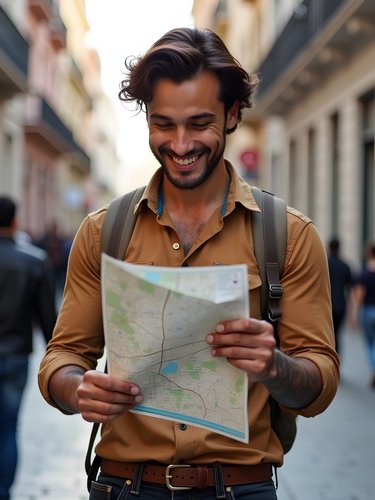
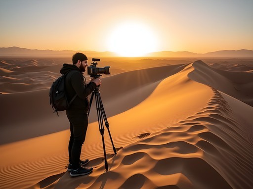
There's something about mountains that speaks to the engineer in me. The way their structural integrity has withstood millions of years of geological forces, the natural load distribution across their slopes, the way water systems carve their own efficient paths downward—it's all a masterclass in design without a human hand involved. When I found myself in Argentina's northwest for a stadium consultation in San Miguel de Tucumán, I couldn't resist the siren call of the nearby Aconquija Mountains. This impressive range, part of the Sierras Pampeanas, rises dramatically from the plains and offers some of the most rewarding day hiking I've experienced in South America. What follows is my structural analysis (so to speak) of five spectacular day trips you can take from Tucumán, complete with the kind of practical details I wish I'd known before lacing up my boots and hitting these magnificent trails.

Getting Your Bearings: The Aconquija Range
Before we dive into specific hikes, let's establish some context—or as we'd say in engineering, let's review the site conditions.
The Aconquija Mountains form part of the Sierras Pampeanas system, running north-south along Argentina's northwest. What makes this range fascinating from a technical perspective is its formation: unlike the Andes (which were pushed up by tectonic plate collision), the Aconquijas rose through a process called block faulting. Imagine massive chunks of earth's crust being forced upward like pistons—that's essentially what happened here over millions of years.
From San Miguel de Tucumán, the provincial capital, you're looking at a 30-60 minute drive to various trailheads. The range creates its own microclimate, acting as a barrier that catches moisture from the east, resulting in lush forests on the eastern slopes (where most of our hikes will be) and dramatically drier conditions on the western side.
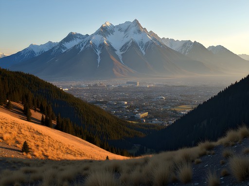
What struck me immediately was the elevation gradient. Within a relatively short horizontal distance, you can move from around 400m above sea level in Tucumán to peaks over 5,000m. That's an impressive structural rise that creates distinct ecological zones you'll pass through on most hikes—from yungas (cloud forests) to high alpine environments. It's like walking through several different climate systems in a single day.
For orientation, I relied heavily on my Garmin GPSMAP 66i, which proved invaluable when trail markings became sparse at higher elevations. The satellite communication feature gave me peace of mind while hiking solo, especially when cell service disappeared (which happens frequently above 2,000m).

💡 Pro Tips
- Download offline maps before heading out as cell service is unreliable
- The weather changes rapidly at higher elevations—always check forecasts the morning of your hike
- Register your hiking plans with your accommodation in Tucumán as a safety precaution
Day Hike 1: San Javier and Villa Nougués
My first foray into the Aconquijas was the perfect calibration hike—a gentle introduction to the region's terrain and conditions. The San Javier and Villa Nougués circuit begins just 12km west of Tucumán, making it the most accessible day trip on this list.
The engineering elegance of this trail is its graduated difficulty. You start with a paved road winding up to the Christ statue at Cerro San Javier (a popular tourist spot), but then branch off onto forest trails that feel remarkably remote despite their proximity to the city. The trail system here functions like a well-designed transportation network, with clear main routes and interesting optional spurs.
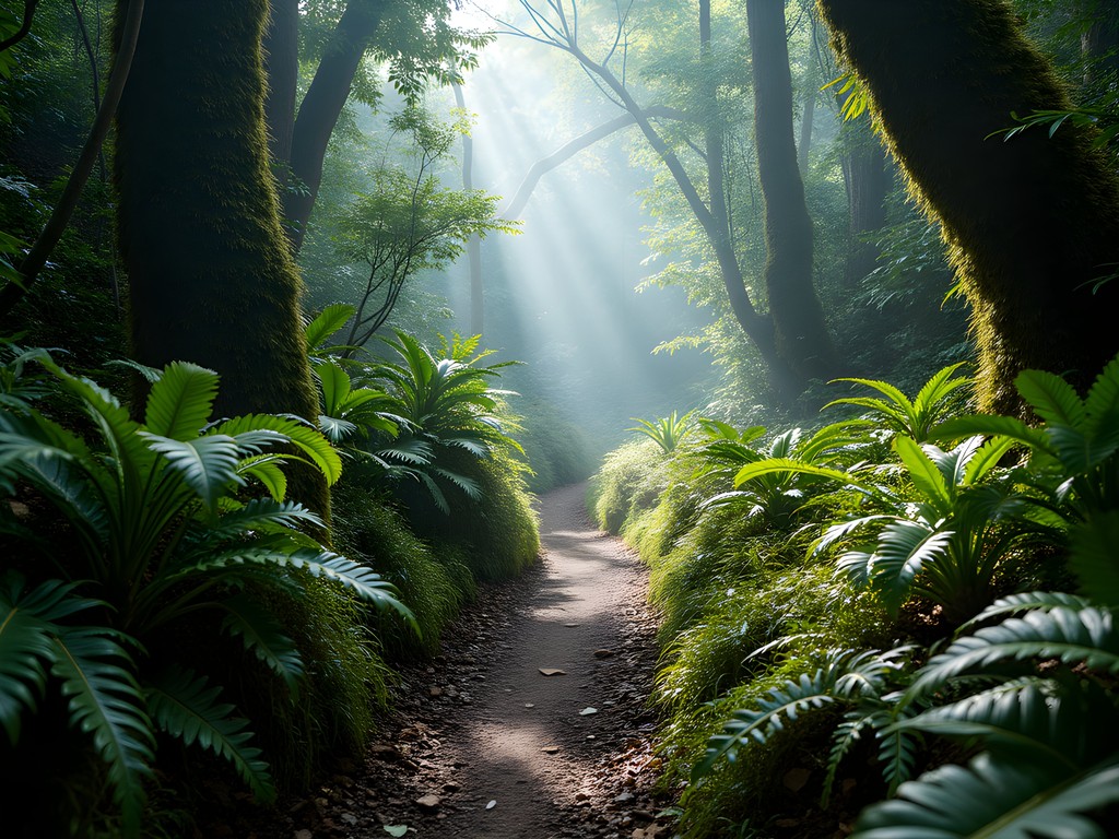
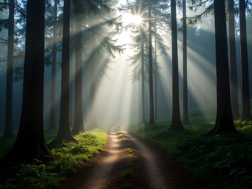
I started early (7:30am) to beat both the heat and weekend crowds. From the Christ statue viewpoint at 1,200m, I followed the trail markers toward Villa Nougués, a charming mountain village that feels transplanted from the European Alps. The trail between these points traverses a beautiful yungas forest—a type of cloud forest ecosystem that's increasingly rare globally.
What fascinated me was how the forest itself acts as a natural climate control system. As I hiked through, the temperature regulation was remarkable—cooler than the city by at least 10°C, with a natural humidity that creates perfect growing conditions for the ferns and bromeliads that carpet the forest floor and hang from trees.
Villa Nougués itself offers a perfect lunch stop at about the halfway point. The village dates to the early 20th century when it served as a summer retreat for wealthy Tucumán families escaping the lowland heat. Several small restaurants serve empanadas tucumanas—the local variation with a slightly sweeter dough than you'll find elsewhere in Argentina.
The return loop takes you through denser forest sections with several streams crossing the path. During spring (September-November), these can be running high, so I was glad I'd packed my quick-dry hiking shoes which handled the occasional water crossing without issue.
💡 Pro Tips
- Start before 9am to enjoy wildlife—I spotted several colorful bird species in the early morning
- Bring cash for lunch in Villa Nougués as card payment can be unreliable
- The full loop is about 12km with 400m elevation gain—suitable for most fitness levels
Day Hike 2: El Siambón and the Monastery Trail
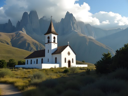
If San Javier was my calibration hike, the El Siambón trail was where I really started to appreciate the Aconquija's unique character. This trail begins about 25km from Tucumán near the Benedictine monastery of El Siambón—a structure that's fascinating in its own right, having been built in 1955 with remarkable adaptation to the mountain environment.
From an engineering perspective, what makes this trail notable is its excellent water management design. Unlike many mountain trails I've hiked globally, the path here has been thoughtfully constructed to handle the significant seasonal rainfall without excessive erosion. Small drainage channels cross the trail at regular intervals, diverting water away from the main path—a simple but effective system that more trail designers should implement.
The hike begins at around 1,300m elevation and climbs steadily through changing forest zones. The first section passes through cultivated yerba mate plantations, where you can observe the systematic layout of this important regional crop. As you gain elevation, the vegetation transitions to native yungas forest and eventually to highland grasslands above 1,800m.
About two hours in, you'll reach a natural viewpoint that offers what engineers might call a 'sectional perspective' of the mountain range—you can clearly see the different ecological zones layered across the mountainside like a natural version of a building cross-section. The panoramic view extends back toward Tucumán and across to the higher peaks of the Aconquijas.
What I particularly appreciated about this trail was its modularity—you can make it as challenging as you want by continuing higher or turning back at several natural stopping points. I pushed on to reach a small mountain stream at about 2,100m where the water quality was exceptional—crystal clear and cold. My water filter bottle made quick work of refilling my supply, though the water here is generally considered safe for drinking directly from fast-flowing sources above human habitation levels.

💡 Pro Tips
- Visit the monastery before or after your hike—the monks produce excellent honey and cheese available for purchase
- The trail can be muddy after rain, so proper footwear is essential
- Look for the rare Tucumán Mountain Finch above 1,800m—its blue-gray plumage is distinctive against the grasslands

Day Hike 3: Raco Valley and Cerro Pelao
For those seeking a more challenging day hike with substantial elevation gain, the trail to Cerro Pelao from Raco Valley offers precisely that. Located about 40 minutes from Tucumán, this hike presents what I'd call an 'efficient vertical design'—maximizing elevation gain through a series of well-placed switchbacks that minimize trail erosion while making the ascent manageable.
The trailhead begins in the picturesque Raco Valley at approximately 1,100m. Unlike the previous hikes, this one wastes no time in gaining elevation. Within the first hour, you'll climb nearly 500m through a transition zone between yungas forest and higher altitude vegetation. The trail itself reminds me of stadium stairway design—it finds the optimal balance between steepness and user comfort.
At around 1,800m, you'll emerge from the forest cover into a landscape dominated by highland grasses and scattered rock formations. This transition point offers your first expansive views of the valley below and is a perfect spot for a brief rest. I found myself analyzing the valley's formation—a textbook example of glacial widening followed by fluvial deposition creating the flat, fertile valley floor now used for agriculture.
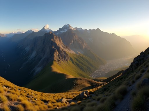
The final push to Cerro Pelao's summit at 2,200m involves some light scrambling over rocky terrain, but nothing requiring technical skills. The trail becomes less defined here, which is where my hiking poles proved invaluable for stability on loose scree sections.
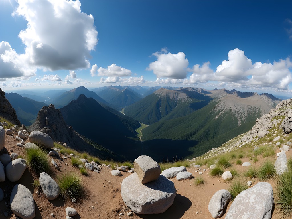
The summit rewards you with a 360-degree panorama that includes the full extent of the Aconquija range to the west and north, while the eastern view stretches across the plains of Tucumán province. On clear days, you can see the transition between the lush eastern slopes and the dramatically drier western side of the range—a perfect illustration of the rain shadow effect that would make any meteorology professor proud.
This hike requires good fitness and proper preparation. The full round trip covers approximately 14km with over 1,100m of elevation gain. I started at 7am and returned to my car by 3pm, including a leisurely lunch at the summit and multiple photography stops.
💡 Pro Tips
- Sign the summit logbook stored in the small cairn at the top—it's a tradition dating back decades
- Weather changes rapidly at higher elevations; pack layers even on sunny days
- The final kilometer has limited shade—plan to reach this section before midday heat or after the hottest part of the afternoon
Day Hike 4: Los Sosa River Valley
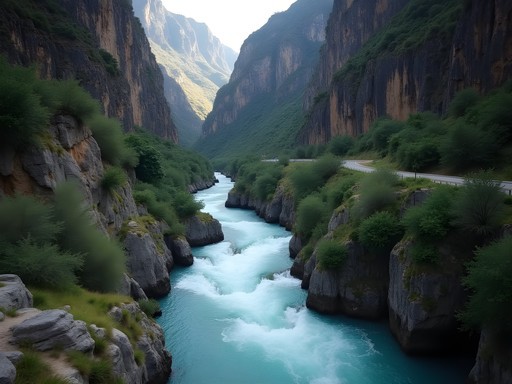
If you're interested in witnessing some impressive natural hydraulic engineering, the Los Sosa River Valley hike should be high on your list. This trail follows portions of the historic Route 307 as it winds through a dramatic river canyon about 50km west of Tucumán.
What makes this hike particularly interesting from my perspective is how it showcases the power of water as a landscape architect. The Los Sosa River has carved an impressive canyon through the mountains, creating a natural water management system that's both beautiful and functionally elegant.
This is less of a traditional trail and more of a combined driving and hiking experience. The old sections of Route 307 (parts have been replaced by modern tunnels and bridges) now serve as excellent hiking paths that parallel the river. You can park at several viewpoints along the new road and explore these abandoned road sections on foot.
I focused my exploration on the section between El Indio and El Fin del Mundo (aptly named 'The End of the World'), where the canyon walls rise nearly vertically on both sides. The old road clings to the canyon wall in a remarkable feat of early 20th-century engineering, with hand-built stone retaining walls still holding firm against the mountain's pressure.
The river below has created a series of natural pools and waterfalls that demonstrate perfect hydraulic jump formations—where fast-flowing water abruptly slows and deepens. During spring, when I visited, the water volume was impressive, creating a constant ambient soundtrack of rushing water that echoed off the canyon walls.
For those interested in both natural and human engineering, look for the sections where the old road builders had to tunnel directly through rock outcroppings. These tunnels, built without modern equipment, show remarkable precision in their construction.
This hike offers excellent flexibility—you can make it as long or short as you prefer by choosing different sections of the old road to explore. I spent about 4 hours covering approximately 8km, with frequent stops to photograph the river dynamics and examine the historic road construction. My waterproof camera was perfect for capturing shots near the waterfalls, where spray was constant and the lighting conditions challenging.

💡 Pro Tips
- Bring a rain jacket regardless of forecast—the canyon creates its own microclimate and sudden showers are common
- The best light for photography is early morning when sunlight reaches the canyon floor
- Look for the remains of the original telegraph poles that once ran alongside the historic road—some wooden crossbeams are still visible
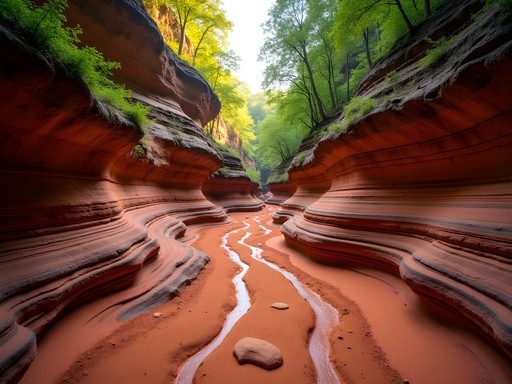
Day Hike 5: Quebrada del Portugués
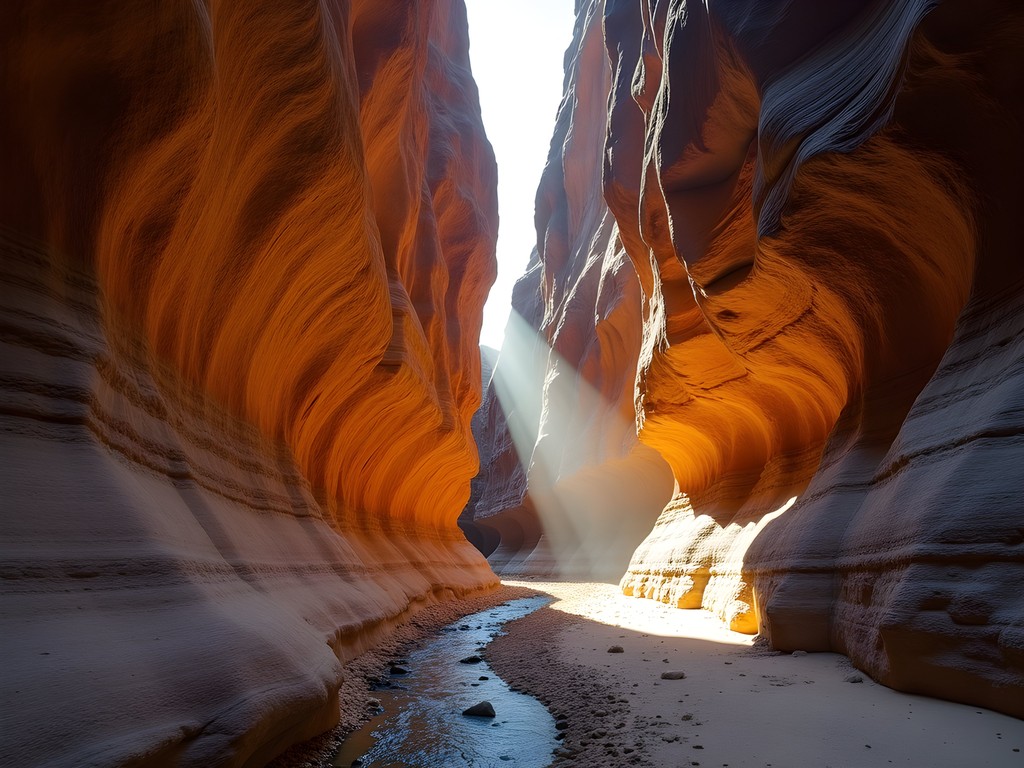
For my final and perhaps most rewarding day hike from Tucumán, I ventured to Quebrada del Portugués—a lesser-known gem that offers some of the most dramatic geological features in the region. Located about 35km southwest of the city near the town of Yerba Buena, this hike follows a narrow quebrada (ravine) that cuts deeply into the mountain flanks.
From an engineering standpoint, this hike is fascinating because it essentially takes you through a natural cross-section of the mountain's internal structure. The ravine walls expose layer after layer of different rock formations, creating what geologists call an 'unconformity'—where you can see millions of years of geological history written in stone.
The trail begins innocuously enough, following a small stream through relatively open terrain. But about 2km in, the walls begin to narrow dramatically, and you enter the true quebrada. At points, the ravine narrows to just a few meters wide, with walls soaring 50+ meters overhead—creating a natural version of the 'urban canyon' effect we sometimes intentionally design in stadium approaches to create drama and control crowd flow.
What makes this hike unique is its progression. Rather than a simple out-and-back, the quebrada presents a series of distinct sections, each with its own character. You'll encounter several small waterfalls that require basic scrambling to navigate—nothing technical, but enough to add a sense of adventure. My dry bag proved essential for protecting camera gear during these water crossings.
About 4km in, the quebrada opens into a hidden valley that feels completely isolated from the outside world. This natural amphitheater is surrounded by peaks on all sides and features a larger waterfall at its head. The acoustics here are remarkable—another reminder that nature often creates perfect sound design without human intervention.
The full hike to the upper waterfall and back covers about 10km with moderate elevation gain (roughly 500m). What makes it challenging isn't the distance or elevation but the terrain—you'll be rock-hopping, wading through shallow water, and navigating uneven surfaces throughout. I spent about 6 hours on this trail, though at least an hour of that was dedicated to photographing the incredible rock formations and working out the geological history they represent.
💡 Pro Tips
- This hike is best avoided during or immediately after heavy rain due to flash flood danger
- Wear shoes you don't mind getting wet—there are multiple unavoidable water crossings
- Pack a headlamp even for day hikes—if you get delayed in the quebrada, the high walls make it get dark much earlier than the official sunset time
Practical Planning: Logistics and Base Camp
Now for the nuts and bolts of your Aconquija adventure—the structural elements that will support your hiking experiences.
Base Camp: San Miguel de Tucumán
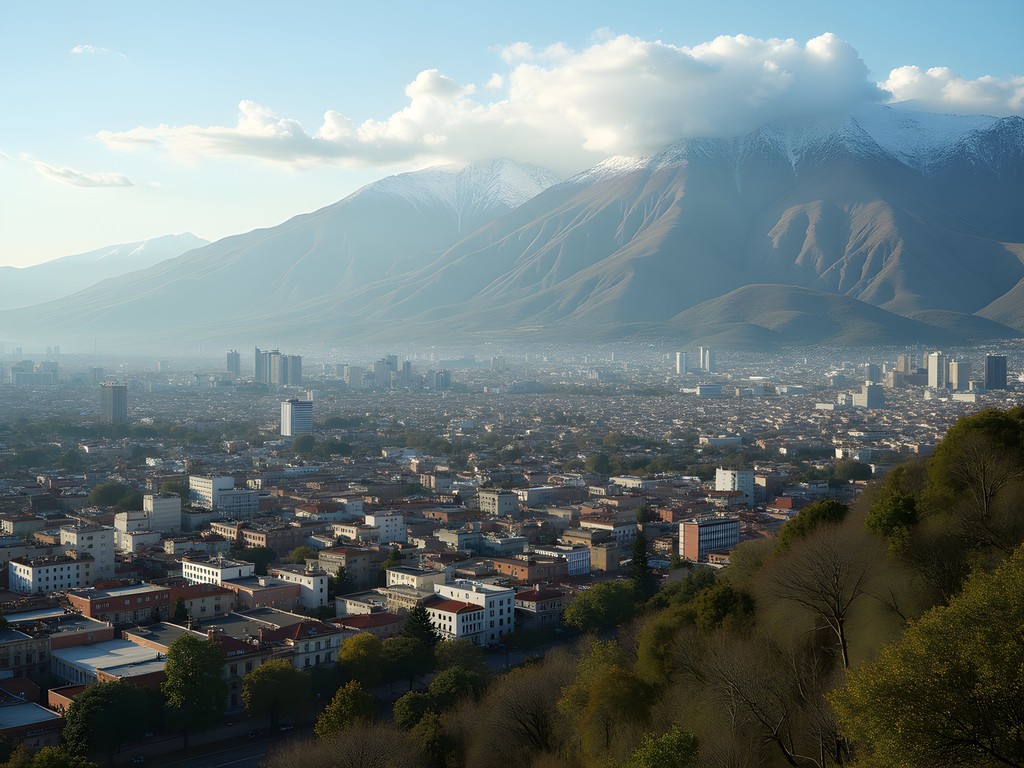
Tucumán makes an ideal base for these day hikes. As Argentina's smallest province by area but one of its most densely populated, the infrastructure here is well-developed. The city itself sits at around 450m elevation, making it a perfect acclimatization point before heading higher into the mountains.
I stayed at Hotel Tucumán Center, which offered reasonable rates (about $50 USD/night) and—crucially for hikers—early breakfast service starting at 6am. This allowed me to fuel up properly before hitting the trails at first light. Several other mid-range hotels in the city center offer similar amenities.
Transportation
While local buses reach some trailheads (particularly San Javier), I found renting a car to be the most efficient solution. Rental rates were surprisingly affordable at around $30-40 USD/day for a basic compact car. Most of the roads to trailheads are paved or well-maintained gravel, so a 4x4 isn't necessary outside rainy season.
If you prefer not to drive, several local tour operators offer hiking excursions to the more popular trails. Tucumán Adventure and Yungas Expediciones both came recommended by locals, with day trips starting around $40-60 USD per person including transportation.
Maps and Navigation
Paper maps of the region are surprisingly difficult to find. Your best bet is to download offline maps before arriving. I used a combination of Gaia GPS and Maps.me, both of which allowed me to download detailed topographic maps of the region. Cell service is spotty at best once you leave the main valleys.
Safety Considerations
The Aconquija Mountains are not extremely high by Andean standards, but they still demand respect. Weather can change rapidly, particularly in spring when afternoon thunderstorms are common. Always check the forecast before setting out, and be prepared to turn back if conditions deteriorate.
Snakes are present in the region, including the occasionally venomous yarará, though encounters are rare. More common are the large golden orb-weaver spiders whose webs often span trails in the yungas forest—harmless but startling when you walk face-first into them at 7am (trust me on this one).
💡 Pro Tips
- Register your hiking plans with your hotel or with local tourism office
- Carry more water than you think you'll need—the humidity makes you sweat more than you might realize
- Learn basic Spanish phrases for emergencies—English is not widely spoken outside tourist areas
Final Thoughts
The Aconquija Mountains represent what engineers like me appreciate most about natural systems—elegant solutions to complex problems, developed over millions of years of evolutionary and geological processes. Each trail I've described offers a different perspective on these mountains, from the accessible forests of San Javier to the dramatic geology of Quebrada del Portugués.
What makes this region special is its accessibility combined with diversity. Within an hour's drive from Tucumán, you can experience ecosystems ranging from subtropical yungas to alpine environments above 2,000m. For the solo traveler on a budget, it offers tremendous value—affordable accommodation, reasonable food costs, and trails that are entirely free to access.
As I packed my hiking gear for the flight back to Galway, I couldn't help but think about how these mountains have influenced the human settlements around them—from the indigenous peoples who first navigated these valleys to the modern city of Tucumán that thrives in their shadow. Like any well-designed structure, the Aconquijas serve multiple functions: watershed protector, biodiversity haven, climate regulator, and now, increasingly, adventure playground.
So lace up your boots, fill your water bottles, and set out to discover your own perfect day hike in the Aconquijas. The mountains are waiting, and they have much to teach those willing to listen.
✨ Key Takeaways
- The Aconquija Mountains offer diverse day hiking options all within an hour of San Miguel de Tucumán
- Spring (September-November) provides ideal hiking conditions with moderate temperatures and blooming vegetation
- Each trail showcases different ecosystems, from yungas cloud forests to high alpine environments
- Most trails can be completed without technical equipment, making them accessible to intermediate hikers
📋 Practical Information
Best Time to Visit
Spring (September-November)
Budget Estimate
$40-60 USD per day excluding accommodation
Recommended Duration
5-7 days to experience multiple trails
Difficulty Level
Intermediate

Comments
coolvibes
This looks amazing but I'm not super experienced with mountain hiking. Would you say the San Javier trail is okay for beginners? I can handle a few hours but nothing too intense. Also is altitude sickness a thing there?
Alex Fisher
San Javier is perfect for beginners! It's more of a steep walk than a technical hike. The altitude tops out around 1,600m so you shouldn't have issues. Just take it slow and bring plenty of water.
sunsetexplorer
Love the monastery photo! So peaceful
Marco Flores
I did the Raco Valley hike last year and it completely blew me away. What you didn't mention is the cloud forest section near the top - it's like walking through a different world. The vegetation changes so dramatically with altitude. I spent three days camping up there and saw condors every morning. The locals in Raco village were incredibly welcoming too. One family invited me for empanadas and told me stories about the old trails. If anyone goes, bring layers - the temperature swings are wild!
coolvibes
Did you need a guide or is it easy to navigate on your own?
Marco Flores
The main trails are well marked, but I'd recommend downloading offline maps. I used Maps.me app and it saved me a couple times when trails split unexpectedly.
exploreking
How's the public transport to San Javier? Thinking of going without a car
Alex Fisher
Pretty reliable actually! Buses run every hour from the main terminal in Tucumán. Takes about 45 minutes. Just check the schedule ahead on weekends.
exploreking
Perfect, thanks!
Timothy Jenkins
Excellent write-up, Alex. I particularly appreciate your engineering perspective on the geological formations - it adds a unique dimension to typical hiking content. I visited the Aconquija Range two years ago and found the cultural aspects equally fascinating. The communities around Villa Nougués have such rich histories tied to the railway development. Did you get a chance to explore any of the old railway infrastructure? The abandoned stations make for compelling photography and tell an interesting story about Argentina's industrial past.
Alex Fisher
Thanks Timothy! I did see some of the old railway bits but didn't explore them thoroughly. That's definitely on my list for next time - the engineering history there must be fascinating.
wanderlustnomad
I was in Tucumán last year and totally missed this! Wish I'd seen your post earlier. We only did the touristy stuff in the city center. The monastery trail sounds really peaceful. Did you need a guide or are the trails pretty well marked? I'm not super experienced with hiking but this looks doable for someone like me.
Timothy Jenkins
Not Alex, but I've done the monastery trail - it's very well marked and perfect for beginners. The monks maintain it quite well. Just bring plenty of water!
nomadphotographer
Those sunset shots from Cerro Pelao are incredible!
skygal
This looks amazing! Quick question - how's the altitude on these trails? I'm planning a trip in July and wondering if I need to worry about acclimatization coming from sea level. Also, how long did the San Javier hike actually take you? The engineering perspective is cool btw, never thought about mountains that way!
Alex Fisher
Great question! San Javier sits around 1,200m so it's pretty gentle. The hike took me about 3.5 hours round trip with photo stops. You shouldn't need much acclimatization for these day hikes. July will be cooler which is nice for hiking!
skygal
Perfect, thanks so much!
argentinafan
Just got back from doing the El Siambón trail you recommended! The monastery was such a peaceful spot for a break. We started early (7am) which I'd definitely recommend to anyone going - by midday the sun was pretty intense. The trail markers were a bit faded in some spots, but we managed with the Maps.me app as backup. Also spotted some amazing birds - bring binoculars if you're into birdwatching!
wanderlustclimber5024
Thanks for the tip about starting early! Planning to go in two weeks.
hikingfan42
Did you feel safe hiking solo? Planning to visit alone next month.
Alex Fisher
I felt very safe on these trails. They're fairly well-marked and popular enough that you'll encounter other hikers, especially on weekends. Just follow standard hiking safety - tell someone your route, bring enough water, and start early.
hikingfan42
Thanks for the reassurance! Looking forward to it.
Venture X
Premium card with 2X miles, $300 travel credit, Priority Pass