

Disclosure: This article contains affiliate links. We may earn a commission from purchases at no extra cost to you, which helps our travel content.
There's something alchemical about the Blue Ridge Mountains in autumn. The transformation happens gradually, then suddenly—like the perfect reduction sauce simmering on a back burner while you're distracted by other things. One moment, you're squinting through summer haze at uniform green slopes; the next, you're standing slack-jawed before a canvas of crimson, amber, and gold that would make even the most jaded photographer fumble for their camera. After fifteen years documenting alpine terrain across three continents, I've developed a particular fondness for Asheville's corner of Appalachia. The trails here offer a democratic kind of wilderness—challenging enough for seasoned hikers but accessible enough for those still breaking in their first pair of proper boots. Last October, my longtime friend Greg and I spent a week based in Asheville, rising early each day to tackle a different trail, returning each evening to the city's exceptional craft breweries and farm-to-table restaurants. What follows is my curated list of seven trails that showcase the region's spectacular autumn display without requiring technical climbing skills or depleting your savings account.

Art Loeb Trail: The Ridge Walker's Dream
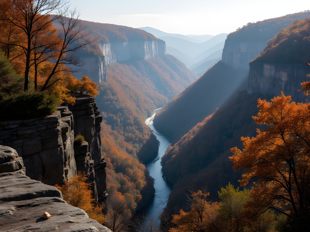
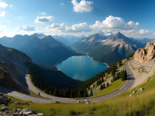
The Art Loeb Trail isn't just a hike; it's a 30.1-mile masterpiece cutting through the spine of Pisgah National Forest. Don't let the total distance intimidate you—the beauty of this trail lies in its segmentation. For our purposes, the Black Balsam Knob to Shining Rock section delivers the quintessential Blue Ridge experience in a manageable 5-mile out-and-back format.
What distinguishes this section is its remarkable ridge walking. Unlike many Appalachian trails that wind through dense forest, Art Loeb treats you to extensive stretches above treeline, where 360-degree views unfold with each step. The balds—natural mountaintop meadows—create an alpine feel more reminiscent of New Zealand's tussock highlands than what you'd expect in the American Southeast.
We hit the trail at 7:30 AM, early enough to catch the morning light raking across the landscape but late enough to avoid fumbling with headlamps. The initial climb from the Black Balsam parking area is moderately steep but mercifully brief. Within 20 minutes, we emerged onto the first bald, where the temperature dropped noticeably and the wind picked up. My windproof jacket earned its keep immediately, blocking the persistent gusts without causing overheating during ascents.
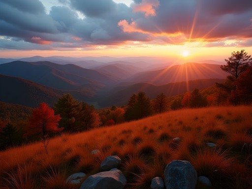
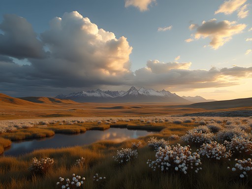
The trail's high point comes at 6,214-foot Black Balsam Knob, where we lingered to photograph the waves of mountains receding into the blue distance. The composition practically creates itself here—layers of ridgelines stacked like theater backdrops, each one progressively hazier than the last. The distinctive Blue Ridge phenomenon for which these mountains are named is most pronounced at dawn and dusk when particulate matter in the air scatters blue light wavelengths.

💡 Pro Tips
- Start early to catch the golden morning light and avoid afternoon thunderstorms that frequently develop in fall.
- Bring extra layers—the exposed ridges can be 10-15°F colder than Asheville with significant wind chill.
- Water sources are limited on the balds; carry at least 2 liters per person.
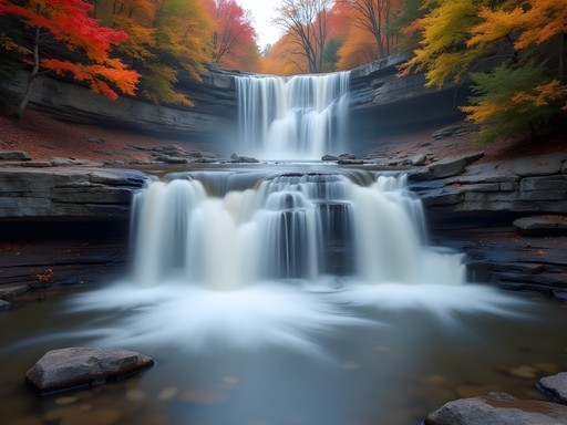
Catawba Falls: The Accessible Cascade
Not every worthwhile hike demands quad-burning climbs. Catawba Falls offers a moderate 3-mile round trip that delivers one of Western North Carolina's most photogenic waterfalls without requiring technical skills or exceptional fitness. Located just 25 minutes east of Asheville, it's an ideal morning excursion before the afternoon crowds arrive.
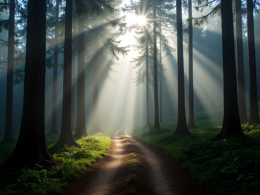
The trail follows the Catawba River upstream through a lush forest of rhododendron, hemlock, and hardwoods. In autumn, the canopy creates a kaleidoscope of color reflected in the clear pools along the path. The relatively flat terrain makes this suitable for mixed-ability groups, though several creek crossings require careful footing on slippery rocks.
Photographing waterfalls presents unique challenges that reward preparation. I've learned through countless soggy mishaps that a lightweight tripod is non-negotiable for achieving those silky water exposures without sacrificing sharpness. The aluminum version offers an excellent balance of stability and portability for hikers watching both weight and budget.
When we visited in late October, the morning mist still clung to the valley, diffusing the light perfectly for long-exposure shots. The waterfall itself cascades over multiple tiers, dropping about 100 feet in total. What makes it particularly photogenic is the way it splits and rejoins across a broad rock face, creating numerous compositional possibilities.
While many hikers snap a few quick photos and head back, I recommend spending time exploring different vantage points. The lower section offers classic frontal views, but climbing carefully to mid-level provides a more intimate perspective where you can frame sections of the falls against the colorful forest backdrop. Just remember that wet rocks and expensive camera equipment make for a potentially costly combination—step thoughtfully.
💡 Pro Tips
- Visit on weekdays or before 9 AM on weekends to avoid crowds.
- Bring microfiber cloths to wipe spray from your lens when shooting close to the falls.
- Wear shoes with good traction; the rocks around the falls are perpetually slick.
Mount Mitchell Trail: The Elevation Champion
For those seeking bragging rights, the Mount Mitchell Trail delivers you to the highest point east of the Mississippi (6,684 feet). This 12-mile out-and-back route from Black Mountain Campground represents the most challenging day hike on my list, with over 3,600 feet of elevation gain. The effort, however, yields rewards proportionate to its difficulty.
What makes this trail particularly fascinating is its demonstration of ecological zonation—essentially traveling from Tennessee to Canada in a single day. As you climb, you'll pass through distinct forest types, culminating in the spruce-fir zone that resembles boreal forests found 1,000 miles north. This ecological progression becomes especially dramatic in autumn when the deciduous trees create bands of color that change with elevation.
We began our ascent at 6:30 AM with headlamps illuminating the first mile. The trail wastes no time gaining elevation, climbing steadily through hardwood forest. By mile three, our breathing had deepened considerably, and we'd shed our outer layers despite the cool morning air. The middle section offers brief reprieves with gentler grades before steepening again for the final push.
At around 5,500 feet, the forest composition shifts dramatically. Deciduous trees give way to Fraser firs and red spruce, their dark green needles creating stark contrast against the occasional flame-orange maple or yellow birch. Near the summit, these conifers become increasingly stunted and weather-beaten, their gnarled forms telling stories of countless winter storms.
The summit itself feels otherworldly—a stone observation platform perched above a sea of mountains stretching to the horizon. On clear days, visibility extends over 100 miles. We lucked out with exceptional conditions, though I've heard from rangers that the peak is cloud-covered roughly 60% of the time.
For this strenuous route, proper footwear is essential. My hiking boots provided the ankle support and traction needed for both the steep ascent and the sometimes treacherous descent, particularly on sections where fallen leaves concealed uneven terrain.
💡 Pro Tips
- Start early—this trail typically takes 6-8 hours for intermediate hikers.
- Check the summit weather forecast before starting; conditions can differ dramatically from those in Asheville.
- Pack layers for the summit, which can be 15-20°F colder than the trailhead.

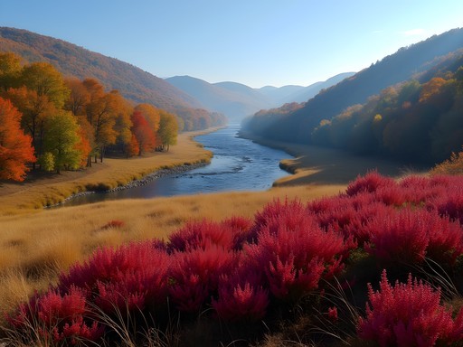
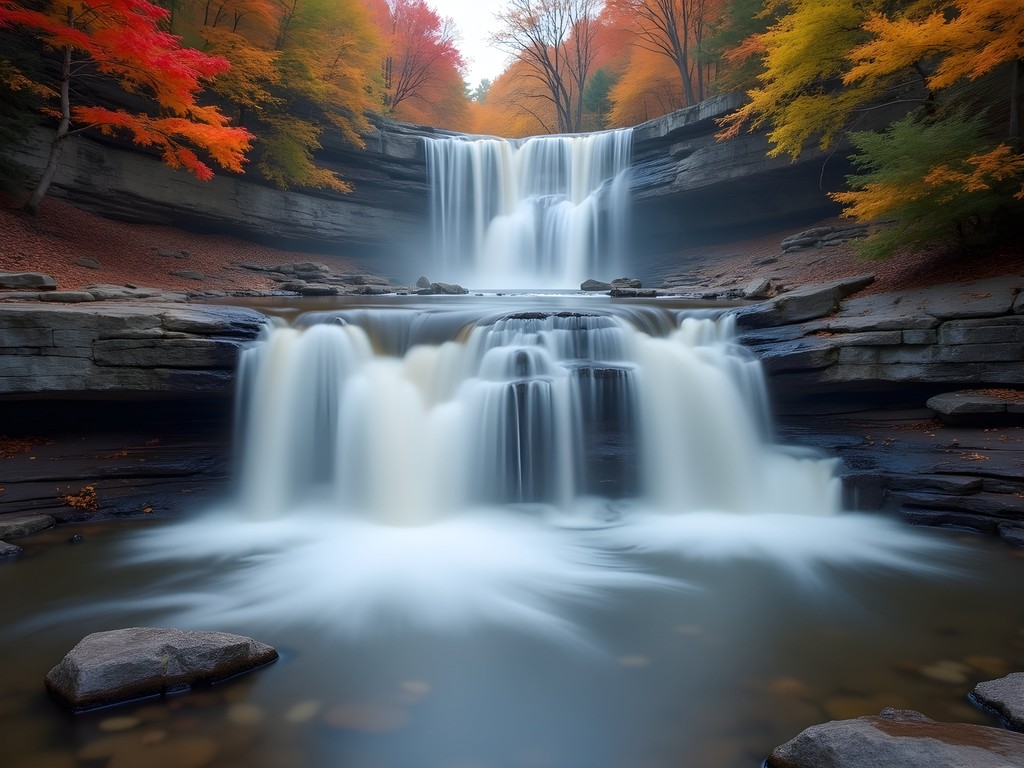
Graveyard Fields Loop: The Family-Friendly Color Explosion
With a name like Graveyard Fields, you might expect something macabre, but this relatively flat 3.2-mile loop offers one of the most accessible and visually rewarding autumn hikes in the region. The unusual name derives from the landscape's appearance after a massive logging operation and subsequent fire left behind tree stumps resembling gravestones—long since disappeared, but the name endured.
What makes this trail exceptional is its unique ecology. Unlike most areas in the Blue Ridge that feature mature forests, Graveyard Fields is a high-elevation valley (around 5,000 feet) dominated by open meadows, dense thickets of blueberry bushes, and young trees. This vegetation profile creates one of the earliest and most spectacular fall color displays in the region, typically peaking 1-2 weeks before lower elevations.
The loop incorporates two notable waterfalls—Upper and Lower Falls—with the latter accessible via a short spur trail just 0.3 miles from the parking area. While photographing the Lower Falls, I discovered that a polarizing filter makes a substantial difference in cutting glare from wet rocks and saturating the autumn colors. My camera filter has become an essential tool for waterfall photography, particularly when fall foliage is reflected in the pools below.
Beyond the waterfalls, the trail winds through meadows filled with blueberry and blackberry bushes that turn brilliant red in autumn. The Yellowstone Prong (stream) cuts through the center of the valley, creating numerous opportunities for water crossings via stepping stones and wooden bridges. These crossings can become challenging after heavy rain, so check conditions before bringing young children.
Despite its accessibility, Graveyard Fields can become disorienting in sections where the trail crosses open areas. Yellow blazes mark the main loop, but they can be easy to miss when distracted by the surrounding beauty. We briefly lost the trail while photographing the valley with late afternoon light streaming through the trees, only to realize we'd wandered into one of the many social paths created by other confused hikers seeking blueberries in summer.

💡 Pro Tips
- Visit at sunrise for the best light and fewest people.
- Pack extra water—despite the moderate terrain, the exposed meadows can be surprisingly hot on sunny days.
- Wear waterproof hiking shoes for stream crossings, especially after rainfall.
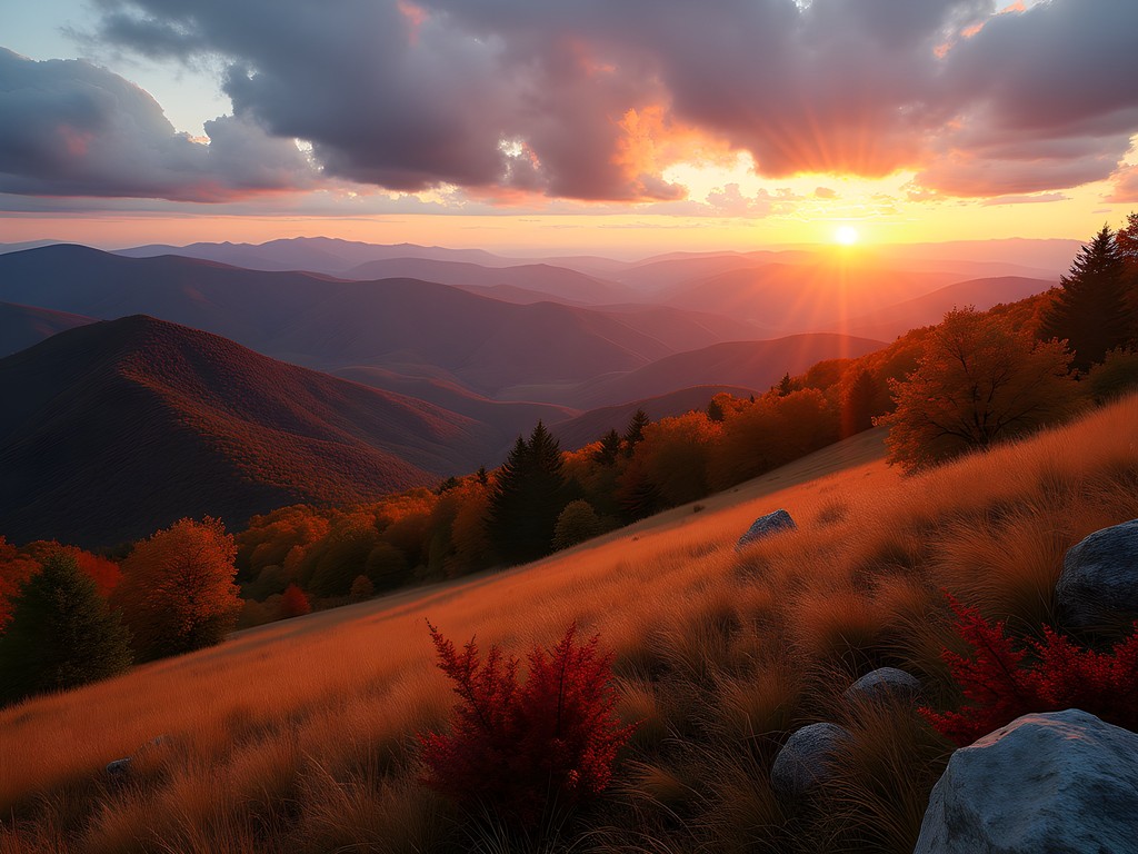
Craggy Gardens Trail: The Sunset Specialist
Some trails are morning trails, best hiked as dawn breaks. Others reveal their magic as the day wanes. Craggy Gardens falls firmly in the latter category, offering perhaps the most spectacular sunset views accessible via a short hike (1.4 miles round trip) anywhere in the Blue Ridge.
Located at Milepost 364.4 on the Blue Ridge Parkway, about 20 miles northeast of Asheville, this trail begins at the Craggy Gardens Visitor Center and climbs gently through a tunnel-like rhododendron forest before opening onto a subalpine meadow. In June, these rhododendrons explode with pink and purple blooms, but in autumn, the meadow itself becomes the star as grasses turn golden and blueberry bushes shift to deep burgundy.
We timed our visit for the golden hour before sunset, arriving at the meadow about 45 minutes before the sun dipped below the horizon. The trail culminates at a sheltered picnic area that provides 360-degree views of the surrounding mountains. The western vista offers the classic sunset shot, but don't neglect the eastern view, where the setting sun paints the ridges in warm light while the valleys fall into purple shadow.
For sunset photography in changing light conditions, a good camera strap proved invaluable, allowing me to quickly transition between handheld and tripod shooting as the light faded. The quick-adjust feature meant I could secure the camera close to my body while navigating the sometimes uneven terrain, then extend it for shooting without removing the strap.
The real magic of Craggy Gardens happens after most visitors have departed. As the direct light fades, the Blue Ridge lives up to its name, with successive mountain ridges appearing in progressively deeper shades of blue. We lingered for the blue hour—that period after sunset but before complete darkness—when the landscape takes on an ethereal quality perfect for moody, atmospheric photographs.
The return hike requires headlamps in autumn when daylight ends early, but the short distance makes this manageable even for those uncomfortable with extensive night hiking. Just be sure to follow the clearly marked trail rather than venturing onto one of several game paths that branch off into the rhododendron thickets.
💡 Pro Tips
- Check Blue Ridge Parkway closures before heading out—sections often close in fall due to weather or maintenance.
- Bring layers for rapidly dropping temperatures after sunset.
- Pack a headlamp even if you plan to return before dark—autumn sunsets can be so captivating you'll likely stay longer than intended.
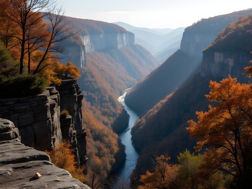
Linville Gorge: The Wilderness Experience
Often called the Grand Canyon of the East, Linville Gorge offers the most rugged and remote experience on this list. The 2,000-foot-deep canyon carved by the Linville River contains numerous trails of varying difficulty, but the Babel Tower Trail provides the best introduction to the gorge's dramatic character within a manageable 2.6-mile round trip.
Don't be fooled by the modest distance—this trail drops 1,000 feet in just over a mile, meaning your knees will feel every step of the return journey. The path begins on the western rim of the gorge and descends steeply through hardwood forest that explodes with color in mid-to-late October. Oak and hickory dominate here, creating a palette of russet and gold different from the more vivid maples found at higher elevations.
About halfway down, the trail emerges onto a series of rock outcroppings that provide sweeping views across the gorge. These natural platforms make perfect spots for photography or simply absorbing the scale of the landscape. The sheer walls of the opposite rim appear to change color throughout the day as light and shadow play across their faces.
The trail ends at the Linville River, where Babel Tower—a distinctive rock formation—rises from the water's edge. The river itself offers excellent opportunities for both landscape and detail photography. I spent nearly an hour capturing the interplay of swirling water, smooth river stones, and fallen leaves carried downstream from the forest above.
Due to its wilderness designation, Linville Gorge trails receive minimal maintenance and blazes are sparse. Navigation requires attention, particularly where autumn leaves obscure the path. A trail map is essential here—don't rely solely on electronic devices as cell service is non-existent throughout most of the gorge.
The wilderness character of Linville extends to its wildlife. During our descent, we spotted a black bear foraging about 100 yards off-trail—a thrilling but important reminder to maintain appropriate distance and practice proper food storage if backpacking. The gorge hosts one of the densest black bear populations in the region, making it both exciting and worthy of respect.
💡 Pro Tips
- Allow twice as much time as you think you'll need—the climb out is strenuous.
- Pack extra water; the steep terrain and lack of services make dehydration a real concern.
- Check weather forecasts carefully; the gorge can become dangerous during heavy rain when the river rises rapidly.
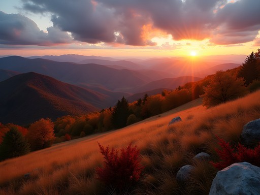
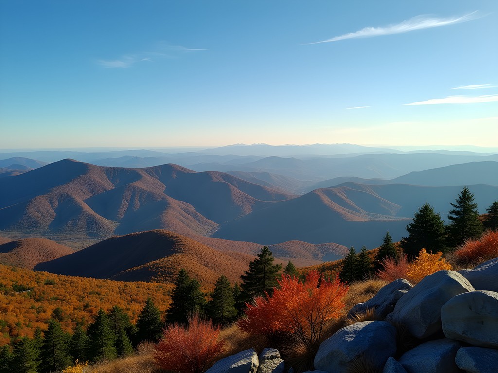
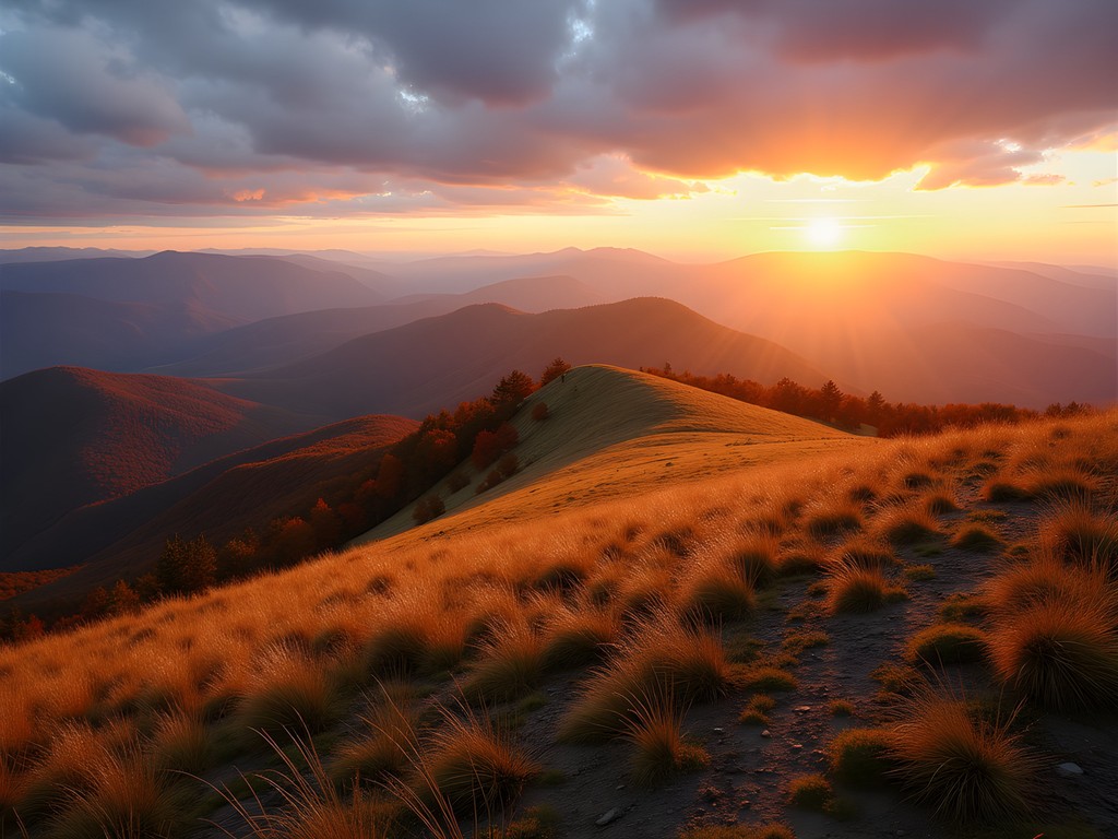
Max Patch: The Appalachian Trail Highlight
Some mountains demand hours of strenuous climbing to reach their summits. Max Patch is not one of them. This 4,600-foot bald mountain, located about an hour's drive from Asheville, offers a rare combination of spectacular 360-degree views and remarkable accessibility. A short 1.4-mile loop trail circles the summit, with several spurs leading to the very top.
What makes Max Patch extraordinary is its status as a 'bald'—a naturally occurring mountain meadow whose origins continue to puzzle ecologists. These open spaces were historically maintained by grazing livestock but are now preserved through periodic mowing. The result is an alpine meadow reminiscent of European landscapes rather than typical Appalachian terrain.
The Appalachian Trail crosses directly over Max Patch, making this an excellent spot for a brief taste of America's most famous long-distance footpath. During our visit, we chatted with several through-hikers nearing the end of their 2,190-mile journey from Georgia to Maine. Their weather-beaten faces and trail-hardened physiques contrasted sharply with the day-hikers who'd driven up for sunset photos.
Photographically, Max Patch offers endless possibilities. The open summit provides unobstructed views in all directions, with layer upon layer of mountains extending to the horizon. In autumn, these ridges display a gradient of color that shifts from peak to valley. The grassy summit itself turns golden in fall, creating a warm foreground for wide-angle landscape compositions.
For our sunset visit, I brought a lightweight blanket to sit comfortably while waiting for the perfect light. This proved essential as temperatures dropped quickly with the sun, and the exposed summit offers no natural shelter from the wind that frequently sweeps across the bald.
While Max Patch's accessibility makes it popular, its vast open space prevents the crowded feeling found at many scenic overlooks. There's room for everyone to find their own private corner of the mountain, especially if you're willing to wander a short distance from the main trail. We found a perfect spot on the eastern side, where the setting sun illuminated distant ridges while casting the valleys into deepening shadow.
💡 Pro Tips
- Visit on weekdays if possible—weekends bring significant crowds, especially during peak fall color.
- Bring wind protection; the exposed summit can experience strong gusts even on otherwise calm days.
- Plan to stay from late afternoon through sunset for the most dramatic lighting conditions.
Final Thoughts
The Blue Ridge Mountains surrounding Asheville offer a remarkable concentration of hiking experiences accessible to intermediate adventurers operating on modest budgets. What distinguishes this region isn't just the quality of individual trails but their proximity to one another—and to Asheville itself. In a single week, you can summit the highest peak east of the Mississippi, photograph multiple waterfalls, traverse alpine-like meadows, and descend into one of the East's most dramatic gorges—all while returning each evening to hot showers and craft beer. The autumn transformation elevates these experiences from merely scenic to truly spectacular, as the landscape becomes a living color wheel that changes daily. If you're planning your own Blue Ridge adventure, consider scheduling your visit for mid-to-late October when colors typically peak at middle elevations. Just remember that flexibility is essential—fall color progression depends on factors ranging from summer rainfall patterns to early frost timing. Most importantly, pack your sense of wonder alongside your hiking boots. Even after decades photographing mountain landscapes worldwide, I find myself repeatedly drawn back to these ancient, rounded summits and their seasonal metamorphosis—a reminder that sometimes the most profound wilderness experiences aren't found in the most remote locations, but in places where natural beauty and accessibility create perfect harmony.
✨ Key Takeaways
- Mid-to-late October typically offers peak fall colors at middle elevations near Asheville.
- Trails range from accessible 1-mile loops to challenging 12-mile summit climbs, accommodating various fitness levels.
- Early morning and late afternoon provide the best lighting conditions for photography and the clearest views.
- Weather can change rapidly in the mountains—always pack layers regardless of valley forecasts.
📋 Practical Information
Best Time to Visit
Mid-October to early November for peak fall colors
Budget Estimate
$500-$800 for a week (accommodation, food, transportation)
Recommended Duration
5-7 days
Difficulty Level
Intermediate (With Options For Beginners)

Comments
Bryce Diaz
The Art Loeb Trail has been on my list forever and this post finally pushed me to commit. I'm planning a solo overnight trip for early October. The way you described that ridge walk—"like the perfect reduction sauce"—that's exactly the kind of poetic hiking experience I'm after. Question though: how's the camping situation along Art Loeb? Are there established sites or is it more dispersed camping?
winterphotographer
There are some established sites but dispersed is allowed too. Just follow Leave No Trace principles!
vacationhero
Really useful guide. One thing I'd add is to download offline maps before you go. Cell service is spotty on a lot of these trails. I use Gaia GPS app and it saved me more than once when the trail markers got confusing.
moonclimber
Going there next month! Can't wait
beachhero
Just got back from Asheville last week and did three of these trails. Graveyard Fields was our favorite—the blueberry bushes were turning red and it was gorgeous. Quick tip: parking fills up FAST at Graveyard Fields on weekends. We got there at 8:30am on Saturday and barely got a spot. Also bring bug spray for Catawba Falls, the mosquitoes were intense near the water.
travelzone
Are these trails doable for someone with moderate fitness? I hike regularly but nothing too intense. Catawba Falls looks perfect for my level.
Bryce Diaz
Catawba Falls is definitely your best bet—it's only about 2.5 miles round trip with manageable elevation. I did it solo last spring and saw families with kids handling it fine. Graveyard Fields Loop is another good moderate option. Save Art Loeb and Mitchell for when you want more of a challenge.
travelzone
Perfect, thanks! That's really helpful.
Sage Dixon
Lars, great roundup! I tackled Art Loeb last fall and it completely changed my perspective on what Carolina hiking offers. The exposed ridgeline sections around Black Balsam are otherworldly—felt like hiking through a watercolor painting. One tip I'd add: start early on Mount Mitchell. We got there at 6am and had the summit practically to ourselves for sunrise. By 10am it was packed. Also, the weather shifts FAST up there, so layers are essential even in summer.
vacationhero
6am start is solid advice. The crowds at Mitchell can be brutal on weekends.
winterninja
Graveyard Fields is amazing! Thanks for sharing
winterphotographer
The fall colors in your photos are absolutely stunning! Did you catch these at peak season? I'm trying to time my visit just right.
moonclimber
Late October is usually the sweet spot for peak colors!
sunnyvibes
OMG the photos don't even do these trails justice!! Just finished the Catawba Falls hike yesterday and it was MAGICAL! The water was running strong after the rain last week. Definitely one of the prettiest waterfalls I've seen on the east coast. Thanks Lars for the recommendation! 😍
sunnylife1970
Planning a trip to Asheville in September. Is that too early for fall colors on these trails? Catawba Falls looks perfect for my skill level!
Lars Berry
September is usually just the beginning of color change at higher elevations. For peak colors, mid-October through early November is your best bet. But Catawba is beautiful year-round - the waterfall makes it worth visiting anytime!
sunnylife1970
Thanks Lars! Maybe I'll do Catawba in September and come back in October for the others. Is the path to the falls well-marked?
globetime
Just did Catawba last week! The trail is super well-marked and maintained. There's a slightly tricky crossing over some rocks near the end but nothing major. The falls are STUNNING right now with all the recent rain!
Venture X
Premium card with 2X miles, $300 travel credit, Priority Pass