

Disclosure: This article contains affiliate links. We may earn a commission from purchases at no extra cost to you, which helps our travel content.
The first time my boots touched Bozeman soil, I felt that familiar tingle of discovery – the same sensation I experienced years ago in the Himalayas. Montana's mountain town revealed itself as a canvas of contradictions: rugged yet gentle, wild yet welcoming. Having traversed mountain trails across four continents, I can confidently say that Bozeman's network of paths offers something truly special – accessibility without sacrificing authenticity. After spending a week exploring the region's diverse terrain last summer, I've curated seven trails that showcase the soul of this magnificent landscape, each one a different brushstroke in Bozeman's natural masterpiece.

The M Trail: Bozeman's Iconic Gateway Hike
Every mountain town has that one signature trail – the one locals recommend first and visitors return to repeatedly. In Bozeman, it's the M Trail. This 1.7-mile round trip climb to the white 'M' emblazoned on Bridger Mountain's flank is both ritual and initiation.
The path zigzags through sagebrush and wildflowers, offering increasingly spectacular views with each switchback. I began my ascent at golden hour, when the valley below was bathed in honey-colored light that transformed ordinary farmland into a patchwork quilt of amber and gold. Though relatively short, the trail gains 850 feet in elevation – enough to make your lungs burn pleasantly if you're still adjusting to Montana's altitude.
What struck me most was the trail's democratic nature. I passed young families with toddlers, university students with their trail running shoes, and elderly couples moving slowly but steadily upward. At the 'M' itself, I pulled out my sketchbook and captured the valley's expanse while chatting with a third-generation Bozeman resident who pointed out landmarks with the pride of someone showing off family heirlooms.
💡 Pro Tips
- Hike at sunrise or sunset for the most dramatic lighting and cooler temperatures
- Pack extra water – the exposed trail offers little shade
- Look for the alternative route down – the steeper path offers different views
Drinking Horse Mountain Trail: The Perfect Balance
Directly across from the M Trail parking lot stands another Bozeman gem – Drinking Horse Mountain. This 2.4-mile loop offers what I consider the perfect balance of accessibility and challenge. The trail's figure-eight design allows hikers to choose between a gentler ascent or a more direct climb to the 5,582-foot summit.
What captivated me about Drinking Horse was its diversity of ecosystems. The path meanders alongside Bridger Creek before climbing through dense forests of Douglas fir and lodgepole pine. Unlike the exposed M Trail, Drinking Horse offers welcome shade and the constant melody of moving water.
Halfway up, I encountered a small meadow bursting with wildflowers – a natural garden that demanded I stop to photograph the delicate blooms. My macro lens attachment transformed my phone into a tool for capturing the intricate details of Indian paintbrush and lupine that carpeted the clearing.
At the summit, a simple wooden bench invites contemplation. I spent nearly an hour there, sketching the ridge lines of the Bridger Range while mountain bluebirds darted between trees – nature's own blue brushstrokes against the green canvas.

💡 Pro Tips
- Take the bridge route up and creek route down for a balanced experience
- Bring trekking poles for the steeper sections if you have knee issues
- Look for the small meditation bench about two-thirds up the mountain
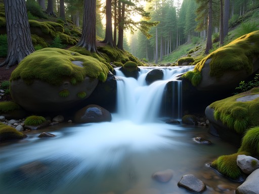
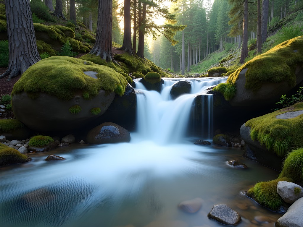
Hyalite Creek Trail: A Symphony of Waterfalls
If I were to translate Hyalite Creek Trail into music, it would be a symphony – one where the recurring motif is falling water. This 11-mile round trip journey takes hikers past eleven distinct waterfalls, each with its own character and voice.
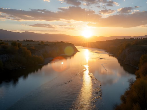
The trail begins in the popular Hyalite Canyon recreation area, about 30 minutes south of Bozeman. I started early, my insulated water bottle filled with ice-cold water that would prove essential as the day warmed. The first miles wind gently through lodgepole forest alongside Hyalite Creek, with periodic breaks in the trees revealing glimpses of the dramatic canyon walls.
What makes this trail special is its accessibility despite the reward-to-effort ratio being extraordinarily high. The path is well-maintained and the elevation gain is gradual enough that moderately fit hikers can comfortably reach even the furthest falls. I passed families with children enjoying the lower cascades, while more determined hikers continued upward.
About four miles in, I reached Apex Falls – a multi-tiered cascade that demanded I unpack my waterproof hiking blanket and spend time simply absorbing the scene. The sound of water striking stone created a natural meditation soundtrack as I sketched the interplay of light through mist and across the moving surface.
💡 Pro Tips
- Start early to secure parking – Hyalite Canyon gets crowded on summer weekends
- Bring a waterproof layer as the mist from falls can soak you unexpectedly
- Pack a lunch to enjoy at Apex Falls before returning

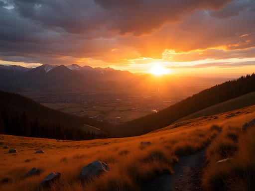
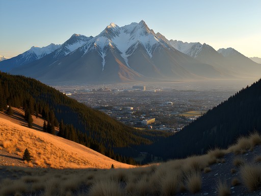
Baldy Mountain: The Challenging Summit Experience
For those seeking a proper mountain challenge, Mount Baldy delivers both the difficulty and the rewards. Rising to 8,914 feet, this prominent peak in the Bridger Range offers a true alpine experience just minutes from downtown Bozeman.
I tackled Baldy on my fourth day in Bozeman, after my legs had acclimated to the altitude. The trail ascends over 4,000 vertical feet in just 4.5 miles (one way), making it a genuine test of endurance. After the initial forest section, the path emerges above treeline where the mountain earns its 'baldy' moniker – a rounded, grassy summit dome exposed to the elements.
The higher I climbed, the more the landscape transformed into something reminiscent of the Himalayan foothills that first kindled my love for mountain journeys. Alpine wildflowers clung to rocky outcroppings, while marmots whistled warnings of my approach. Near the summit, I encountered a mountain goat family traversing a seemingly impassable cliff face with balletic grace.
The summit itself is a place of perspective – both visual and philosophical. The 360-degree panorama encompasses the entire Gallatin Valley, neighboring mountain ranges, and on clear days, even glimpses of Yellowstone. I pulled my down jacket tight against the summit winds and spent an hour absorbing the vastness, sketching ridge lines that seemed to extend to infinity.

💡 Pro Tips
- Start very early – afternoon thunderstorms are common in summer months
- Bring layers for the summit, which can be 10-15 degrees cooler than the trailhead
- Pack extra food and water – this hike demands more energy than its distance suggests
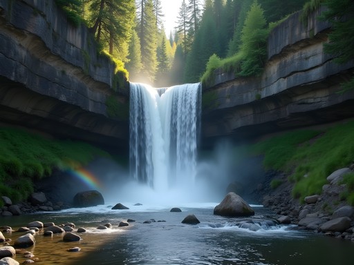
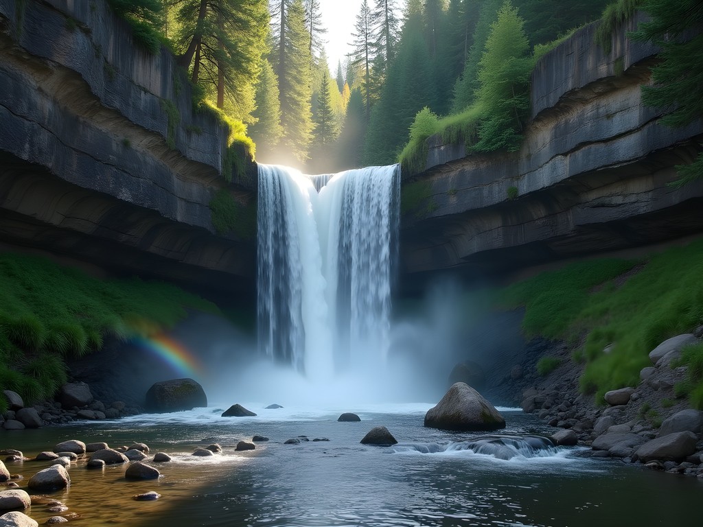
Palisade Falls: Nature's Accessible Masterpiece
Not every meaningful outdoor experience requires an epic journey. Palisade Falls proves this beautifully – offering spectacular scenery via a paved quarter-mile trail that's accessible to almost everyone, including those with mobility challenges or families with strollers.
Located in Hyalite Canyon (the same recreation area as Hyalite Creek Trail), Palisade Falls showcases an 80-foot waterfall cascading over a dramatic volcanic rock wall. The contrast between the dark basalt columns and the white water creates a natural composition that speaks to my artist's sensibility.
What makes this trail special isn't just its accessibility but the quality of the destination. Unlike many 'easy' hikes that sacrifice drama for convenience, Palisade delivers a genuinely spectacular scene. I visited mid-morning when sunlight created rainbows in the mist at the fall's base – a phenomenon I captured with my polarizing filter to enhance the vibrant colors.
After photographing the falls from various angles, I found a quiet spot away from other visitors and pulled out my watercolors. The interplay of shadow and light on the columnar basalt presented a delightful challenge – how to capture something simultaneously geometric and organic, powerful yet delicate.
This trail reminded me that nature's most profound experiences aren't always hidden behind miles of difficult terrain. Sometimes, they're deliberately placed where more people can access them – a democratic approach to natural wonder that I deeply appreciate.
💡 Pro Tips
- Visit on weekdays to avoid crowds – this is one of Bozeman's most popular short hikes
- Bring a spray jacket if you want to approach the base of the falls
- Look for interpretive signs explaining the volcanic geology of the area
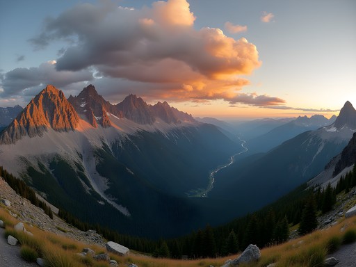
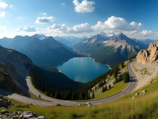
Lava Lake: The Alpine Jewel
Some landscapes feel like they were created specifically to be painted or photographed. Lava Lake is precisely such a place – an alpine jewel nestled in a rocky cirque that rewards hikers with a scene straight from a mountain fantasy.
The trail to Lava Lake begins in Gallatin Canyon, about 30 minutes south of Bozeman. The 6-mile round trip follows Cascade Creek through dense forest, gaining 1,600 feet of elevation. While moderately challenging, the trail is well-maintained and suitable for intermediate hikers who can handle steady climbing.
What makes this hike memorable is the dramatic reveal. After miles of forest hiking with limited views, the trail suddenly emerges at the lake's edge, where the landscape opens into a spectacular alpine cirque. The first time I saw it, I actually gasped audibly – the vibrant blue water reflecting the surrounding peaks created a mirror world that doubled the visual impact.
I spent hours circumnavigating the lake, finding different perspectives to sketch and photograph. My ultralight camp chair proved invaluable, allowing me to sit comfortably at various vantage points rather than perching on rocks or damp ground.
As afternoon clouds gathered, creating dramatic light patterns across the water, I understood why this lake has become something of a pilgrimage for Bozeman locals and visitors alike. It embodies the essence of Montana's mountain character – not the highest or largest, but perfectly formed and positioned to create maximum visual impact.

💡 Pro Tips
- Bring insect repellent – mosquitoes can be intense near the lake in early summer
- Pack a water filter to refill bottles from the lake for the return journey
- Allow extra time at the lake – you'll want to linger longer than planned
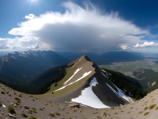
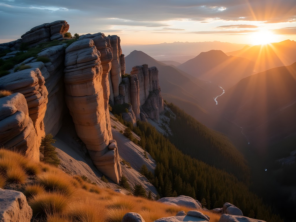
Storm Castle Peak: The Panoramic Throne
My final recommendation is perhaps my personal favorite – a trail that combines reasonable difficulty with extraordinary rewards. Storm Castle Peak rises dramatically from Gallatin Canyon, its distinctive profile visible from miles away. The trail to its summit is a 5-mile round trip adventure that gains 2,000 feet in elevation.
What distinguishes this hike is the continuous unfolding of views. Unlike trails that save all their scenic rewards for the summit, Storm Castle offers increasingly spectacular vistas with each switchback. The path winds through changing ecosystems – starting in sagebrush, transitioning through pine forest, and finally emerging onto exposed limestone ridges.
I began my ascent at dawn, my headlamp lighting the way through the lower sections. This early start allowed me to witness the sunrise from halfway up the mountain – a moment when the entire Gallatin Canyon was filled with golden light while the western slopes remained in purple shadow.
The final approach to the summit involves a brief scramble up limestone formations that give the peak its castle-like appearance. Standing atop the summit feels like occupying a throne overlooking a vast mountain kingdom. The 360-degree panorama encompasses the Gallatin Range, Madison Range, and Spanish Peaks – a geography lesson written in stone and sky.
I spent three hours at the summit, alternating between sketching, photography, and simply sitting in contemplation. A golden eagle soared on thermals below my perch – a moment that crystallized why I travel thousands of miles to experience these wild places. Some views change you permanently, and Storm Castle's is among them.
💡 Pro Tips
- Wear sturdy footwear with good traction for the final scramble to the summit
- Start early to catch morning light and avoid afternoon heat on exposed sections
- Bring wind protection – the summit can experience strong gusts even on calm days
Final Thoughts
As I packed my sketchbooks and hiking boots at the end of my week in Bozeman, I realized that these seven trails had offered me something beyond mere exercise or scenic views. They had provided a complete portrait of Montana's mountain character – from accessible paths that welcome everyone to challenging summits that demand proper preparation and respect.
What struck me most was how the Bozeman community has maintained these trails with evident care, creating infrastructure that enables connection to wilderness without diminishing its essential wildness. This balance – between access and preservation – reminds me of the best mountain regions I've visited worldwide.
Whether you have a single afternoon or a full week, Bozeman's trail network offers adventures scaled to your ability and ambition. Each path reveals a different facet of this remarkable landscape, from thundering waterfalls to serene alpine lakes, from wildflower meadows to panoramic summits. In a world where true wilderness becomes increasingly precious, Bozeman stands as a gateway to experiences that remain transformative in their beauty and power. The mountains are calling – and Bozeman's trails provide the perfect answer.
✨ Key Takeaways
- Bozeman offers exceptional hiking diversity within minutes of downtown
- Trails range from accessible paved paths to challenging mountain summits
- Summer brings ideal hiking conditions, though early starts avoid afternoon storms
- The region balances recreational access with wilderness preservation beautifully
📋 Practical Information
Best Time to Visit
June through September, with July-August offering most reliable weather
Budget Estimate
$500-800 for a week (lodging, food, transportation)
Recommended Duration
4-7 days to experience a variety of trails
Difficulty Level
Options Range From Easy To Challenging, Most Trails Intermediate

Comments
tripgal
Beautiful photos! Definitely adding this to my bucket list
Jean Wells
Excellent guide, Amit. I've hiked extensively in Montana and your trail selections cover the spectrum well. One addition for readers: the Drinking Horse Mountain Trail offers superior wildflower displays in late June through mid-July. I've documented over 40 species there. Also worth noting that cell service is nonexistent on most of these trails, so download offline maps beforehand. The Bridger Range weather patterns are notoriously unpredictable - afternoon thunderstorms are common from July through August.
wildblogger
Baldy Mountain kicked my butt last year but totally worth it. Started at 6am to beat the heat and the sunrise from halfway up was incredible. The last mile is brutal - loose rocks and serious elevation gain. Took me about 5 hours round trip. Pro tip: the weather changes FAST up there, I got caught in a surprise hailstorm on the descent. Bring layers even if it looks sunny.
skyperson
Going in September - is that too late in the season? Worried about weather and trail conditions. Also saw a bear warning sign last time I was in Montana, should I be concerned on these trails?
Jean Wells
September is actually ideal - fewer crowds and the fall colors are stunning. Bears are present but encounters are rare if you make noise and carry bear spray. I always hike with my bear spray attached to my pack belt for quick access.
skyperson
thanks! definitely getting bear spray now
Claire Hawkins
Amit, your description of Hyalite Creek Trail brought back memories! We took our kids (7 and 10) there last summer and they absolutely loved the waterfalls. It became this magical treasure hunt for them, counting each cascade. The trail is gentle enough that our youngest managed the whole thing without complaining once - which is basically a miracle! We packed sandwiches and ate by the creek. Fair warning though, the mosquitoes in July were intense, so bug spray is essential. Would love to go back and try Drinking Horse Mountain next time.
tripgal
This is so helpful! I'm bringing my nephew so good to know it's kid friendly
tripchamp
M Trail is no joke! Great views tho
tripgal
How hard is it really? I'm not super experienced but want to try it when I visit in August
tripchamp
steep at parts but doable if you take breaks. bring lots of water
freevibes
Just got back from Bozeman and used this guide for our hiking plans - spot on descriptions! The Hyalite Creek Trail was magical, even with a light rain. Saw a moose near the third waterfall! One thing to add - the parking at The M fills up SUPER early on weekends. We arrived at 9am and had to wait for a spot.
skyguy
Been hiking Bozeman trails for years and this is a solid list. One tip for Baldy Mountain - the false summit tricks a lot of first-timers. When you think you're at the top, you've still got about 20 minutes to go! The views from the actual summit are much better, so don't turn around early.
skybackpacker
Planning a trip to Bozeman in October - will these trails still be accessible or should I worry about snow by then?
Kimberly Murphy
October can be hit or miss in Bozeman! The lower trails like The M and Drinking Horse should be fine, but Baldy might get early snow. Always check trail conditions before heading out and bring microspikes just in case!
skybackpacker
Thanks Kimberly! Appreciate the advice. Will definitely pack those microspikes.
Adam Nichols
Interesting selection of trails, Amit. I appreciate how you've structured this by difficulty level - it's something I always look for in hiking guides. Having done extensive hiking across Montana last summer, I'd note that trail conditions on Baldy Mountain can deteriorate quickly after rain. The soil composition there makes for surprisingly slippery conditions even a day after precipitation. For those planning to tackle multiple trails, the elevation differences between these hikes provide excellent acclimatization progression. The M Trail serves as perfect preparation for Drinking Horse, which then readies you for the more demanding trails. Well-considered guide.
Venture X
Premium card with 2X miles, $300 travel credit, Priority Pass