


Disclosure: This article contains affiliate links. We may earn a commission from purchases at no extra cost to you, which helps our travel content.
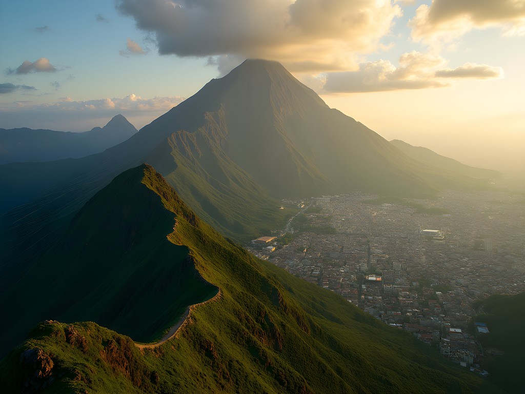
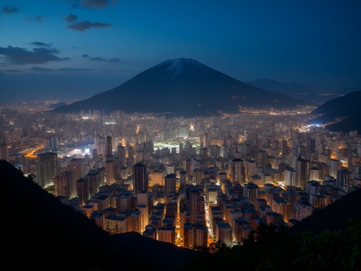
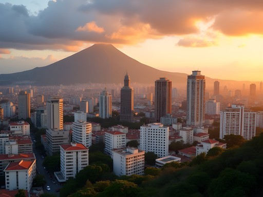
The first time I stood beneath the imposing silhouette of El Ávila, I felt that familiar tug of curiosity that has pulled me toward mountains across five continents. This massive green guardian of Caracas rises like a verdant wall between city and sea, creating one of the most dramatic urban-mountain interfaces I've encountered. Locally known as Waraira Repano in indigenous Caribe language, meaning 'Sierra Grande', this mountain isn't just a geographical landmark—it's the soul of Caracas, a constant presence visible from nearly every corner of the city. Having tackled it during three separate visits to Venezuela, I've compiled this guide to help fellow adventurers experience what I consider one of South America's most underrated urban hiking experiences. Pack your boots and prepare for a journey that balances challenging terrain with breathtaking rewards.

Understanding El Ávila: Geography and Significance
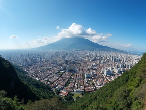
El Ávila National Park spans approximately 85,000 hectares, with the mountain itself reaching 2,640 meters (8,661 feet) at Pico Naiguatá, its highest point. What makes this mountain particularly special is its dramatic rise from near sea level to alpine heights within such proximity to a major metropolis. The locals call it El Pulmón de Caracas—the lung of Caracas—and this isn't mere poetic license. The mountain creates its own microclimate, trapping clouds on its northern face while providing critical ecological services to the city below.
During my first visit in 2014, a local botanist explained that El Ávila hosts over 1,800 plant species, many endemic to this mountain system. The ecological zones transition dramatically as you ascend: from dry forest at the base through cloud forest at mid-elevations to páramo (high-altitude tropical alpine grasslands) near the summit. This biodiversity hotspot represents Venezuela's remarkable ecological wealth in miniature.
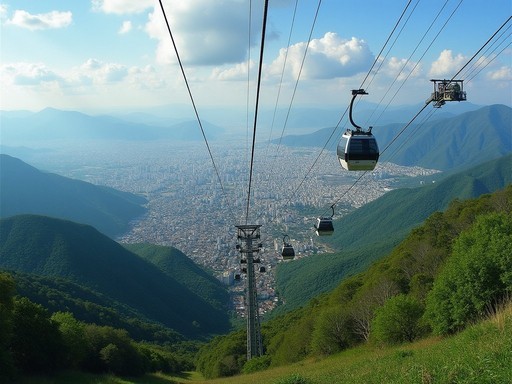
Culturally, El Ávila is woven into the identity of Caraqueños. When sketching the city's skyline from various vantage points, I've observed how the mountain serves as both backdrop and character in Caracas' urban story. On weekends, the mountain transforms into a social space where families, athletes, and nature lovers escape the city's intensity. The cable car (teleférico) that connects Caracas to the coastal region of Macuto further emphasizes the mountain's role in connecting disparate Venezuelan landscapes.
💡 Pro Tips
- The mountain is officially called Waraira Repano National Park, though most locals still refer to it as El Ávila
- The park contains over 200 bird species—bring binoculars if you're interested in birdwatching
- Visit the small museum at the teleférico station to learn about the mountain's ecological and cultural significance
Choosing Your Route: The Three Classic Ascents
Over my three visits to Caracas, I've tackled each of the primary routes up El Ávila, each offering distinct experiences and challenges. Your choice should depend on your fitness level, available time, and what aspects of the mountain you most want to experience.
1. La Sabana to Pico Ávila (Teleférico Route)
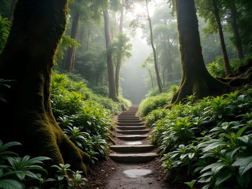
This is the most popular and accessible route, beginning at the entrance near the neighborhood of San Bernardino. The trail follows a well-maintained path that zigzags up the mountain's southern face. What makes this route special is how quickly you transition from urban noise to forest serenity—within 30 minutes, the city sounds fade entirely.
On my first ascent via this route, I was struck by how the vegetation changes with elevation—from cacti and dry-adapted plants near the base to increasingly lush cloud forest as you climb. The hike takes approximately 3-4 hours to reach the upper teleférico station at 2,135m, where a small complex offers restaurants and viewpoints.
2. Quebrada Quintero (The Adventurer's Route)
For those seeking a more challenging experience, Quebrada Quintero offers a steeper, less trafficked alternative. This route begins in the eastern part of Caracas and follows a stream bed before ascending more dramatically. The trail is less maintained, requiring occasional scrambling over rocks and roots—perfect for those seeking a more authentic wilderness experience.
During my ascent via this route, I relied heavily on my trekking poles to navigate the steeper sections. The extra stability they provided proved invaluable on the loose terrain. This route takes 4-5 hours and rewards hikers with more solitude and wilder landscapes.
3. Sabas Nieves to Los Venados (The Local's Favorite)
Beginning at the Sabas Nieves entrance in Altamira, this route offers perhaps the best balance of accessibility and wilderness experience. The lower section is quite popular with local fitness enthusiasts, but as you climb beyond the second refuge (Sabas Nieves II), the crowds thin considerably. The path to Los Venados station offers spectacular views of both the city and the Caribbean on clear days.
This was the route I took during my most recent visit, and I found the well-spaced refugios (small shelters) perfect for pacing the ascent. My hydration pack proved essential on this 5-6 hour journey, as water sources are limited and the Venezuelan sun can be unforgiving even in winter months.

💡 Pro Tips
- The Sabas Nieves route has two refuges with bathrooms and water points
- Quebrada Quintero requires better navigation skills—download offline maps before attempting
- All routes become significantly more challenging in rainy conditions—check weather forecasts carefully
Essential Preparation: Safety and Logistics
Hiking El Ávila requires thoughtful preparation, particularly for international visitors unfamiliar with Venezuelan conditions. Having made some mistakes during my first visit that I corrected in subsequent trips, I can offer guidance that goes beyond the typical advice.
Security Considerations
Let's address the elephant in the room: Caracas has security challenges that travelers should acknowledge. However, El Ávila itself is generally considered safe for hiking, particularly if you follow some basic precautions. Hike in groups when possible, start early (I recommend beginning no later than 8:00 AM), and avoid carrying obviously valuable items. On all three of my visits, I encountered nothing but friendly locals eager to share their mountain with visitors.
I've found that hiring a local guide for your first ascent provides both security and enriches the experience through local knowledge. The Asociación Venezolana de Guías de Montaña can connect you with certified guides who know the mountain intimately.
Weather and Timing
El Ávila creates its own weather patterns, with the northern slope often cloud-covered while the southern side facing Caracas remains clear. The dry season (December to April) offers the most reliable conditions, with January and February providing particularly clear views. Even in winter, however, afternoon thunderstorms can develop rapidly.
On my second visit, I learned the hard way that starting too late can mean encountering afternoon fog that obscures the spectacular views that make the climb worthwhile. For photography enthusiasts like myself, early morning starts (around 6:00 AM) provide the best light for capturing both the mountain and city vistas.
Essential Gear
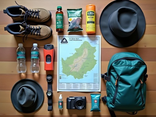
Despite being close to a major city, El Ávila demands proper hiking equipment. The temperature difference between Caracas and the upper elevations can be substantial—I've experienced drops of 10-15°C (18-27°F).
My essential gear list includes:
- Sturdy hiking boots with ankle support
- Layered clothing (I always pack a lightweight but warm fleece jacket even on seemingly warm days)
- Minimum 2 liters of water
- High-energy snacks (local markets sell delicious panelas - raw sugar blocks - that provide excellent energy)
- Rain shell (afternoon showers can develop quickly)
- Sun protection (the Venezuelan sun is intense, even in winter)
- Basic first aid supplies
- Fully charged mobile phone (there is surprisingly good coverage on most of the mountain)
For serious photographers, I recommend bringing a lightweight tripod for capturing the dramatic city lights if you plan to descend near sunset, though this requires careful timing and preferably a guide familiar with night descents.

💡 Pro Tips
- Register with park officials at the entrance—this safety measure ensures someone knows you're on the mountain
- Carry some local currency for emergencies or refreshments at the refugios
- The national park officially opens at 7:00 AM, but locals often start hiking earlier—arriving at entrance points before official opening can allow earlier access

Summit Experiences: What Awaits at the Top
After hours of ascent through changing ecosystems, reaching El Ávila's higher elevations delivers experiences that make every step worthwhile. The summit areas offer distinctly different rewards depending on which destination you choose.
Pico Ávila and the Teleférico Complex
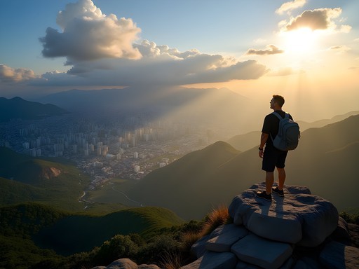
Reaching the upper teleférico station at Pico Ávila (2,135m) feels like arriving at an island in the sky. The contrast between the physical exertion of the climb and the suddenly civilized environment—complete with restaurants and souvenir shops—creates an almost surreal transition. On weekends, this area bustles with both hikers who have made the ascent and day-trippers who have taken the cable car from below.
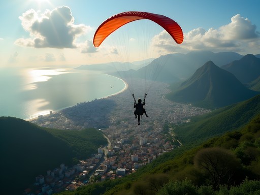
During my first visit, I was initially disappointed by the commercial development at the top—until I walked just 15 minutes away from the main complex. The crowds quickly thin, and you can find spectacular viewpoints in relative solitude. One of my favorite spots lies along the trail toward the Hotel Humboldt, where a natural rock outcropping provides panoramic views of both Caracas and the Caribbean coast.
The historic Hotel Humboldt itself deserves exploration—this mid-century architectural gem has a fascinating history tied to Venezuela's boom years. Though it has gone through periods of abandonment and restoration, its retro-futuristic design remains captivating. I spent an hour sketching its distinctive silhouette against the mountain backdrop.
Los Venados: The Wilderness Experience
For those seeking a more natural summit experience, the Los Venados station offers a perfect alternative. Located at approximately 1,800m, this area features a small refuge rather than commercial development. The surrounding cloud forest here is enchanting, often shrouded in mist that parts occasionally to reveal spectacular views.
During my visit to Los Venados, I encountered several species of hummingbirds darting among flowering plants. My compact binoculars proved invaluable for wildlife observation here—the mountain hosts over 100 bird species, many endemic to the region.
Pico Naiguatá: For the True Adventurer
At 2,640m (8,661ft), Pico Naiguatá represents the ultimate El Ávila challenge. This summit requires significantly more preparation, typically involves an overnight stay, and should only be attempted with experienced guides. Though I haven't personally reached this summit, fellow hikers I met described the terrain as increasingly alpine, with páramo vegetation and rock scrambling required near the top.
The views from Naiguatá are reportedly unparalleled, offering vistas that stretch far along the Caribbean coast and deep into the Venezuelan interior on clear days. This remains on my list for a future visit, when I can allocate the necessary 2-3 days for a proper attempt.

💡 Pro Tips
- At the teleférico complex, food prices are significantly higher than in the city—bring your own lunch to save money
- The early morning hours (before 10 AM) and late afternoon (after 4 PM) offer the best photography light and clearest views
- Carry an extra layer even on clear days—cloud and fog can envelop the summit quickly, dropping temperatures dramatically
Cultural Encounters: The Human Side of El Ávila
What makes El Ávila truly special isn't just its natural splendor but the human connections and cultural dimensions that unfold along its slopes. As an artist drawn to cultural intersections, these aspects of the mountain have fascinated me across multiple visits.
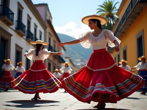
The Sunday Pilgrimage
Visit El Ávila on a Sunday morning and you'll witness what amounts to a cultural institution for Caraqueños. Families, fitness enthusiasts, elderly couples, and youth groups all make their way up the mountain in a weekly ritual that transcends mere exercise. During my Sunday hike on the Sabas Nieves route, I joined this multi-generational procession and found myself welcomed into conversations despite my obviously foreign appearance.
One memorable encounter was with an elderly gentleman in his 70s who told me he had hiked the mountain every Sunday for over 40 years. "El Ávila knows more about me than any priest," he joked as we shared a rest stop. These weekly pilgrimages represent a fascinating cultural resilience—even during Venezuela's most challenging economic periods, this tradition has continued unabated.
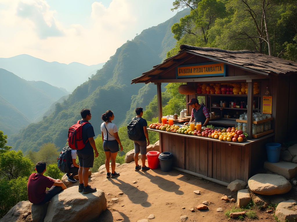
Mountain Vendors and Local Flavors
Along popular routes, especially on weekends, you'll encounter local vendors selling everything from fresh fruit to traditional Venezuelan snacks. At Sabas Nieves I, a woman has sold fresh jugo de caña (sugarcane juice) from the same spot for decades. The sweet, refreshing drink costs little but delivers perfect natural energy for the climb.
Near Los Venados, I met a man selling tequeños (Venezuelan cheese sticks) that he carried up in an insulated container. These fresh, warm cheese-filled pastries tasted infinitely better at altitude after hours of hiking than any energy bar could hope to match.
These micro-economies represent important income sources for local families while enhancing the hiking experience. Bringing small denominations of local currency allows you to support these traditions.
Artistic Heritage
As an artist, I was drawn to the creative expressions that appear throughout the mountain. Near the Quebrada Quintero route, local artists have created small installations using natural materials—stone arrangements and sculptural interventions that complement rather than intrude upon the landscape.
The mountain has also inspired generations of Venezuelan painters, poets, and musicians. During my most recent visit, I was fortunate to meet a local watercolorist capturing the interplay of light through the cloud forest. We exchanged techniques and perspectives on how mountains shape creative vision across cultures.
For those interested in this artistic heritage, the small museum at the teleférico station displays works inspired by El Ávila throughout Venezuelan art history, providing cultural context that deepens appreciation of the landscape.
💡 Pro Tips
- Learn a few basic Spanish phrases—locals appreciate the effort and are often more willing to share their mountain knowledge
- Sunday mornings see the mountain at its most social—go then if you want cultural immersion, or weekdays if you prefer solitude
- Ask vendors about their history with the mountain—many have fascinating stories that span decades of El Ávila's changing circumstances
Final Thoughts
El Ávila stands as a testament to the extraordinary relationship between a city and its mountain—a relationship I've rarely seen matched in my travels across five continents. More than just a hiking destination, it represents the resilience of both nature and Venezuelan culture through changing times. As I sketched the mountain's profile from my hotel room on my final morning in Caracas, I reflected on how El Ávila offers something increasingly rare in our hyperconnected world: an authentic wilderness experience accessible by public transportation from a major metropolitan center.
Whether you're drawn to challenging hikes, cultural connections, or simply the need to find perspective above the urban rhythm, El Ávila delivers with a distinctly Venezuelan character. As the locals say, "No conoces Caracas hasta que conoces El Ávila"—you don't know Caracas until you know El Ávila. I invite you to discover both.
✨ Key Takeaways
- El Ávila offers world-class hiking with multiple route options suitable for different experience levels
- Proper preparation regarding timing, security, and equipment ensures a safe and rewarding experience
- The mountain represents both an ecological treasure and a cultural institution for Caracas
- Winter months (December-April) provide the most reliable weather conditions for summit attempts
📋 Practical Information
Best Time to Visit
December to April (dry season), with January and February offering the clearest views
Budget Estimate
$10-30 USD per day (excluding accommodations) depending on transportation and guide needs
Recommended Duration
Full day (7-9 hours) for most summit routes; 2-3 days for Pico Naiguatá
Difficulty Level
Moderate To Challenging Depending On Route Choice And Fitness Level

Comments
oceanstar
is the cable car still running? heard mixed things about it being open or closed
oceanbuddy
love the photos!
Marco Flores
Excellent guide, Amit! I tackled the Pico Oriental route last spring and it was hands down one of my favorite urban mountain experiences. The biodiversity is insane - I spotted three different hummingbird species in one morning. For anyone planning this: the trail markers aren't always obvious, so download an offline map beforehand. I used my GPS device and it saved me from taking a wrong turn near the ridge. Also, the arepas at the top station are simple but hit different after that climb!
adventurenomad7118
going next month!! any tips?
oceanbuddy
start early. like 6am early. gets hot fast
happyfan
YES!! El Ávila is absolutely incredible! Did this last year and still thinking about it. The sunrise from the top is unreal!!!
Sophia Gomez
Amit, this brought back so many memories! I hiked El Ávila during a business trip to Caracas in 2019 and it completely changed my perception of the city. I took the cable car up (I'll admit it!) but hiked down via one of the trails. The contrast between the urban sprawl below and the cloud forest ecosystem on the mountain is just surreal. One thing I'd add - the weather can change FAST up there. I started in sunshine and ended up in thick fog within an hour. Layer up and bring a rain jacket even if it looks clear!
oceanstar
did you feel safe hiking alone there? planning a solo trip
Sophia Gomez
I went with colleagues, but there were plenty of groups on the trails. I'd recommend going on weekends when it's busier and sticking to the main routes. Check current safety conditions before you go.
wavelegend
how hard is this for someone whos never really hiked before? looks amazing but kinda intimidating lol
Marco Flores
Start with Sabas Nieves route if you're new to hiking - it's the most gradual. Take your time, bring lots of water, and maybe go with a local guide your first time. The views make every step worth it!
wavelegend
thanks! gonna look into guides
bluetime
Thanks for this! I did the Sabas Nieves route last week and it was tougher than I expected but totally worth it. The section through the forest was my favorite part - felt like being in a different world. Pro tip: bring some snacks for the capuchin monkeys at the top, they're super friendly but don't feed them anything unhealthy. Also my hiking boots were perfect for the rocky sections. The trail can be slippery after rain so good grip is essential!
sunsetwanderer
Omg monkeys!! Now I definitely have to go
freediver
Going there next month! Super excited
Taylor Moreau
Excellent comprehensive guide. I've hiked El Ávila twice during business trips to Caracas and it's become a must-do for me when I'm in the city. The cable car option is convenient if you're short on time, though the hiking experience is far more rewarding. I'd emphasize the importance of proper hydration - the combination of altitude and tropical sun can be deceptive. I always carry at least 2 liters of water. The Hotel Humboldt at the top makes for an interesting photo opportunity, even if it's not fully operational. Worth noting that weekends can be quite busy with local families.
Venture X
Premium card with 2X miles, $300 travel credit, Priority Pass