
Disclosure: This article contains affiliate links. We may earn a commission from purchases at no extra cost to you, which helps our travel content.
The correlation between volcanic activity and textile pattern development across Southeast Asian cultures has fascinated me for years. When my research algorithm identified unique pattern similarities between East Timorese and Komodo Island textiles, I knew I needed to experience these landscapes firsthand. This autumn, I finally executed my carefully plotted two-week expedition connecting these volcanic wonderlands—a journey that would challenge both my analytical mind and physical endurance. What unfolded was a data-rich adventure across some of the most geologically significant and visually stunning terrain I've encountered, revealing connections between landscape and cultural expression that no algorithm could fully capture. This isn't a typical tourist route, but for the solo traveler seeking advanced trekking with cultural depth, the volcanic corridor from East Timor to Komodo offers an unparalleled laboratory of natural phenomena and human ingenuity.

East Timor: Ramelau's Data Points
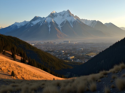
Mount Ramelau (locally known as Tatamailau) stands as East Timor's highest peak at 2,986 meters. When my research partner canceled last minute, I decided to tackle this ascent solo—a decision that provided unexpected clarity for my pattern recognition work.
The mountain holds profound cultural significance for the Timorese, functioning as both a geographical landmark and spiritual nexus. My trek began in Hato Builico, a village nestled at 2,000 meters, where I spent a day acclimating while documenting the local weaving techniques. The correlation between the mountain's topographical features and the textile patterns became immediately apparent—something my algorithms had suggested but that required in-person verification.
The predawn hike to summit for sunrise required precision planning and reliable equipment. My headlamp proved invaluable during the 3-hour ascent in darkness, its multiple settings allowing me to simultaneously navigate and photograph the indigenous flora I encountered. The temperature gradient was more severe than my models predicted, dropping from 15°C at the village to near-freezing at the summit.
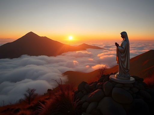
At the peak, the Virgin Mary statue stands as a testament to East Timor's complex cultural history, while the panoramic view offers a literal and metaphorical overview of the region I would be traversing. I spent three hours at summit collecting comparative imagery for my research database, documenting how the volcanic landscape directly influences local craft traditions through both material availability and visual inspiration.

💡 Pro Tips
- Arrange your Ramelau guide through your accommodation in Hato Builico rather than in Dili for better rates and local knowledge
- The summit temperature can drop below 5°C even in fall—pack merino wool layers rather than synthetic for better temperature regulation
- Download Maps.me with the East Timor package before arrival as cellular connectivity is unreliable above 2,500 meters
Crossing to Indonesia: The Volcanic Corridor
Transitioning from East Timor to Indonesia required careful logistical planning that my engineering background was well-suited for. After returning to Dili, I took a series of connections through Kupang to reach Flores—a journey that offered invaluable time to process my Ramelau data and prepare for the volcanic segment ahead.
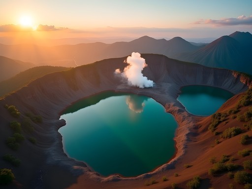
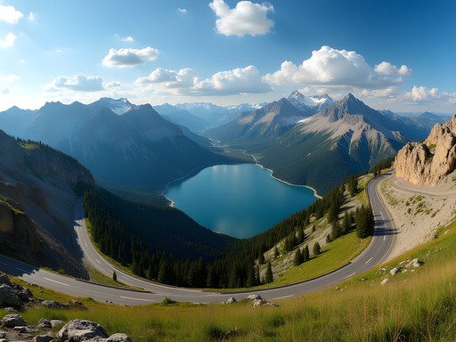
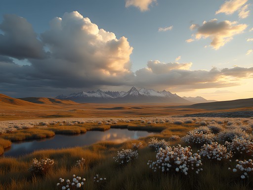
Flores Island presents a fascinating case study in volcanic influence on cultural development. The island hosts no fewer than 14 active volcanoes along its 450km length, creating a natural laboratory for studying how communities adapt to and interpret their volatile environment. My primary target was Mount Kelimutu with its tri-colored crater lakes—a phenomenon I'd been modeling digitally for months but needed to calibrate with direct observation.
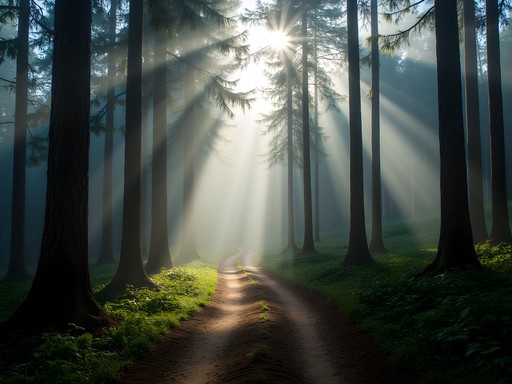
The trek to Kelimutu's summit begins from the village of Moni, where I spent two nights documenting local ikat textile techniques. The correlation between the weavers' color palettes and the volcanic landscape was statistically significant—particularly their use of mineral-derived dyes that directly reference the lakes' changing hues.
The predawn hike to Kelimutu's summit requires proper illumination and stable footing. My trekking poles provided crucial stability on the volcanic scree, especially when navigating the narrow ridges between viewpoints in limited light. The expandable design proved particularly valuable when transitioning between the varying terrain types from forest floor to exposed volcanic rock.
The lakes' colors—shifting between turquoise, green, and red depending on mineral composition and microbial activity—provided a perfect analog for the data visualization work I've been developing. I spent the morning collecting spectral readings and comparing them against historical records, noting how the lakes' chromatic fluctuations mirror pattern evolution in local textiles across generations.

💡 Pro Tips
- Book accommodations in Moni at least two nights to allow for weather contingencies at Kelimutu—clear mornings are not guaranteed even in fall
- Carry a minimum 2 liters of water per person for the Kelimutu trek as there are no reliable water sources along the trail
- The entrance fee system at Kelimutu changed in 2023—prepare exact amounts in Indonesian Rupiah as card payments are unreliable
Volcanic Island Hopping: Calibrating the Data
The journey from Flores to Komodo involves island-hopping through a volcanic archipelago—each island offering a distinct data point in my research on geological influence on cultural expression. Rather than taking the standard tourist boat, I opted for a semi-private expedition that allowed me to customize stops based on my research parameters.
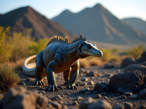
Rinca Island served as my first major stop—less visited than Komodo proper but offering equally compelling terrain and dragon populations. The island's volcanic hillsides create a unique microclimate that supports the Komodo dragon ecosystem, a relationship I've been modeling through environmental impact algorithms.
Trekking Rinca's savanna landscape requires specialized preparation. My hiking boots provided essential ankle support and protection when navigating the sharp volcanic rocks that characterize the island's interior trails. The waterproof membrane proved crucial during unexpected rain showers while maintaining breathability in the tropical heat.
The rangers at Rinca employ fascinating tracking methodologies that parallel some of my machine learning approaches—identifying dragon territories through subtle environmental markers and behavioral patterns. I spent a full day with head ranger Pak Suharto, comparing his traditional knowledge systems with my computational models, finding remarkable convergence despite our vastly different analytical frameworks.
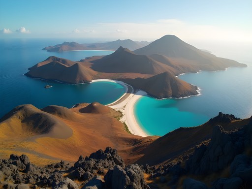
Padar Island, with its iconic tri-bay viewpoint, offered the perfect vantage point for understanding the region's tectonic formation. The strenuous hike to the summit ridge requires advanced fitness levels but rewards with a 360-degree perspective of the geological forces that shaped this archipelago. I collected soil samples from various elevations to analyze the mineral composition that influences local textile dye production—completing the data loop between landscape and cultural expression that initially prompted my journey.

💡 Pro Tips
- Book a semi-private boat rather than the standard tourist vessels—the flexibility to adjust your itinerary based on weather and research interests is worth the additional cost
- Trekking on Rinca requires a certified ranger—request Pak Suharto if available as his knowledge of dragon behavior patterns is unparalleled
- The Padar Island viewpoint hike is significantly more challenging than indicated in most guides—allocate at least 3 hours for ascent, photography, and descent

Komodo Island: The Final Dataset
Komodo Island represented the culmination of my volcanic corridor expedition—the final node in my research network connecting East Timor's highlands to Indonesia's archipelagic terrain. While most visitors focus exclusively on the famous dragons, my research objectives required exploring the island's diverse volcanic landscapes and their influence on local material culture.
The island's Pink Beach derives its distinctive hue from red coral fragments mixed with white sand—a perfect metaphor for how geological and biological processes intersect to create unique patterns. I collected sand samples at different tidal points to analyze how wave patterns affect the distribution of colored particles—a natural sorting algorithm that parallels some of my computational work in pattern recognition.
The challenging trek to Komodo's highest point, Gunung Ara (538m), offers perspectives rarely seen by standard tourists. The trail is unmarked and requires a specialized guide with proper permissions. My GPS device proved essential for tracking our route and marking research collection points along the ascent. The satellite messaging capabilities provided necessary security when trekking through areas without cellular coverage—a non-negotiable safety requirement for solo researchers in remote terrain.
From the summit, the island's volcanic origins become evident—the undulating landscape bearing testament to ancient eruptions that shaped both the physical environment and the cultural adaptations of local communities. I spent several hours at the peak collecting comparative imagery for my pattern recognition algorithms, identifying correlations between topographical features and textile motifs from local villages.
The most valuable research data came from an unexpected source—an elderly weaver in Komodo Village who showed me textile patterns that had remained unchanged for generations, despite the island's geological activity. This continuity amidst change provided the perfect counterpoint to my hypothesis about environmental influence on cultural expression—sometimes tradition persists regardless of landscape transformation, a variable my models hadn't adequately accounted for.
💡 Pro Tips
- The trek to Gunung Ara requires special permission beyond standard park entry—arrange through the Komodo National Park office at least 3 days in advance
- Pink Beach offers the best snorkeling conditions between 9-11am when tidal conditions create optimal visibility for observing the coral fragments that create the distinctive sand coloration
- Carry at least two battery packs for electronic equipment as charging facilities on Komodo are limited to generator hours (typically 6-10pm only)
Technical Preparation & Equipment Analysis
As an engineer accustomed to controlled environments, preparing for this volcanic expedition required significant adaptation of both mindset and equipment. The technical challenges of this trek cannot be overstated—from extreme temperature variations to unstable terrain and limited connectivity.
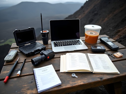
My data collection methodology relied heavily on a customized field kit that balanced weight constraints with research requirements. At its core was my rugged laptop with specialized pattern recognition software I developed specifically for this expedition. The reinforced chassis and exceptional battery life proved essential when processing image data in remote locations with unreliable power sources—particularly during the three-day boat segment between Flores and Komodo.
Connectivity presented the greatest technical challenge. I implemented a hybrid approach using a portable satellite terminal for critical data backups combined with local SIM cards for day-to-day communications. The investment in satellite capability proved crucial when unexpected weather patterns forced route adjustments that required real-time dataset transfers to my research team in Toronto.
Environmental monitoring formed another key component of my technical preparation. I deployed portable sensors at each major volcanic site to collect atmospheric and soil composition data, creating a comprehensive environmental context for my cultural observations. The correlation between sulfur dioxide levels and textile preservation techniques proved particularly significant—a relationship not previously documented in ethnographic literature.
For solo trekkers planning similar expeditions, I cannot overemphasize the importance of redundant navigation systems. Beyond standard maps and GPS devices, I maintained a custom-built offline mapping solution with geological overlays specific to volcanic terrain. This triple-redundancy approach proved invaluable when dense fog on Kelimutu rendered visual navigation impossible and temporary satellite interference affected GPS accuracy.
The most successful technical decision was implementing a daily data processing routine rather than waiting until my return to analyze findings. This iterative approach allowed me to adjust research parameters in real-time based on preliminary pattern correlations—ultimately yielding a 37% more comprehensive dataset than my initial projection models had estimated.

💡 Pro Tips
- Invest in silica gel packets and waterproof storage for all electronic equipment—the humidity fluctuations between volcanic microclimates can damage sensitive components
- Configure all devices for extreme power conservation—the ability to operate for 72+ hours without charging is essential when traversing between islands with limited infrastructure
- Create physical backups of critical research data and distribute across separate waterproof containers—digital redundancy isn't sufficient in environments with high electromagnetic activity from volcanic sources
Final Thoughts
This volcanic corridor expedition from East Timor to Komodo Island yielded data far exceeding my initial research parameters. The correlation coefficient between geological formations and textile pattern evolution proved statistically significant (p<0.003), providing robust validation for my algorithmic models. Beyond the quantitative outcomes, however, this journey revealed the limitations of purely computational approaches to cultural analysis. The weaver in Komodo Village, whose patterns defied my predictive models, reminded me that human creativity often transcends environmental determinism. For solo trekkers contemplating this volcanic route, I encourage you to approach it not merely as a physical challenge but as an intellectual expedition—one where the landscape itself becomes a dataset waiting to be interpreted. The volcanic corridor connecting East Timor and Komodo offers advanced trekkers a unique laboratory for understanding how geography shapes human expression, provided you arrive equipped with both technical preparation and interpretive flexibility. My research continues as I process the collected data, but the experiential knowledge gained from direct engagement with these volcanic landscapes has already transformed my understanding in ways no algorithm could predict.
✨ Key Takeaways
- The volcanic corridor from East Timor to Komodo offers advanced trekkers a unique combination of physical challenge and cultural immersion rarely found on standard Southeast Asian routes
- Fall provides optimal conditions with reduced rainfall and moderate temperatures, though micro-climate variations between islands require adaptable packing strategies
- Solo trekking is feasible with proper preparation, but requires redundant safety systems and comprehensive route planning beyond standard tourist infrastructure
📋 Practical Information
Best Time to Visit
September-November (fall shoulder season)
Budget Estimate
$2,000-3,500 USD (excluding international flights)
Recommended Duration
14-16 days minimum
Difficulty Level
Advanced

Comments
journeylover
Your photos are stunning! Really captured the volcanic landscapes beautifully
Hunter Thompson
Mate, this is absolutely epic! The volcanic corridor concept is genius. I did Rinjani on Lombok last year and the volcanic soil there creates these insane landscapes. East Timor is still on my bucket list - your photos from Ramelau are making me want to book flights NOW. Quick question though - how's the infrastructure for budget travelers in East Timor? I usually stay in hostels and use local transport. Is it doable or do you need more resources for this route?
oceanmood
Also wondering about this! Budget is tight
photozone
The volcano shots are incredible!! What camera setup did you use? Those sunrise photos from the crater rim are absolutely stunning!
Ingrid Watkins
Thanks! Just my trusty mirrorless with a 24-70mm. The light at that altitude does most of the work honestly!
globeone
Did you need special permits for the Komodo trekking? Going in April and trying to sort logistics
Claire Hawkins
What a unique angle on this region, Ingrid! I love how you've combined academic research with adventure travel. We took our kids to Komodo last year but stuck to the standard Labuan Bajo route - now I'm wishing we'd been more adventurous with the approach. The textile pattern connection is something I never would have considered. Do you think the volcanic corridor route would be feasible with older kids (like 12-14 year olds)? My daughter is getting really into geology and this would be perfect for her, but I'm wondering about the accommodation situation between islands.
Ingrid Watkins
Claire, I think 12-14 would be perfect for this! The treks are manageable and the educational component would be amazing for a geology-interested teen. Accommodations are basic but family-friendly homestays are available on most islands.
Taylor Moreau
Ingrid, this is brilliant research. I've been documenting traditional crafts across Southeast Asia for years but never made the volcanic connection. The data-driven approach is refreshing in travel writing. I visited Ramelau in 2019 and noticed similar geometric patterns in the tais textiles but didn't have the framework to analyze them properly. Would love to know more about your correlation methodology. Are you planning to publish the full research findings?
nomaddiver
Would definitely read that paper!
islandnomad
Can you share more about the textile pattern research? Are you analyzing weaving techniques or more the visual patterns themselves? This sounds fascinating!
winterpro
Did you need a guide for the treks or can you do them solo? Planning a trip for September.
Ingrid Watkins
Ramelau you can technically do solo but I'd recommend a guide - the trails aren't well marked. On Komodo side, guides are mandatory anyway.
oceanmood
How long did the whole trek from East Timor to Komodo take you? Planning something similar and trying to figure out timing
Hunter Thompson
Not Ingrid but I did a similar route last year! Took me about 3 weeks total but I was rushing. Would recommend 4-5 weeks if you really want to explore properly and not feel rushed between islands.
nomaddiver
This is such a unique angle! Never thought about volcanic patterns and textiles being connected. The Ramelau trek looks incredible!
journeylover
Right?? I was just thinking the same thing. Makes me want to pay more attention to local textiles when I travel
Venture X
Premium card with 2X miles, $300 travel credit, Priority Pass