
Disclosure: This article contains affiliate links. We may earn a commission from purchases at no extra cost to you, which helps our travel content.
When most travelers think of Iceland's Golden Circle, they envision tour buses pulling up to Gullfoss waterfall, crowds gathering around Geysir's predictable eruptions, and the obligatory selfie at Þingvellir National Park. But having just returned from my third visit to this geological wonderland—this time extending a manufacturing conference in Reykjavík into a week of solo exploration—I'm here to tell you that Iceland's most famous tourist route harbors alpine secrets that most visitors never discover. As someone who's built a career finding efficiency in manufacturing processes, I've applied the same strategic thinking to uncovering mountain trails that parallel the Golden Circle's popular attractions but offer solitude, challenge, and perspectives that simply can't be experienced from the designated viewing platforms.

Planning Your Golden Circle Hiking Extension
My approach to Iceland has always been methodical, balancing the efficiency I value in my professional life with the authenticity I seek in travel. After three visits, I've refined a strategy that allows you to experience both the iconic sights and the hidden alpine trails without a rental car—crucial for solo travelers looking to minimize expenses while maximizing experiences.
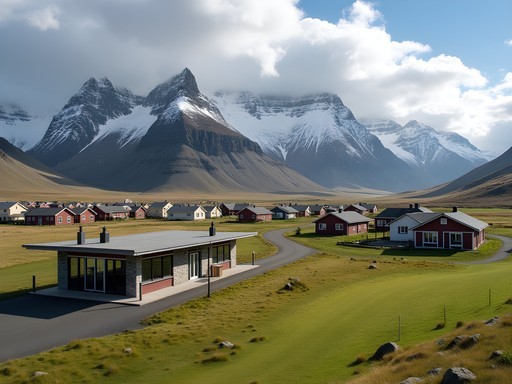
The conventional Golden Circle can be completed in a day, but to properly explore its mountain trails, allocate at least 4-5 additional days. I based myself in Selfoss, a practical hub with regular bus connections to key trailheads and significantly more affordable accommodation than Reykjavík.
For transportation, Iceland's public bus network is surprisingly comprehensive in summer. I purchased the Iceland Travel Card which covers most regional buses and proved to be excellent value compared to guided tours or rentals. For trail navigation, cell service is unreliable in the highlands, so I relied heavily on my Garmin GPSMAP which doubles as a satellite communicator—essential safety equipment when hiking solo in remote areas.
Accommodation-wise, I discovered that mountain huts managed by the Iceland Touring Association (Ferðafélag Íslands) offer the perfect balance of comfort, authenticity, and strategic locations for multi-day hikes. Book these months in advance, especially for summer visits.

💡 Pro Tips
- Book mountain huts 6-8 months in advance for summer hiking
- The Iceland Travel Card saves approximately 30% compared to individual bus tickets
- Download offline maps from the Icelandic Hiking Association before departure
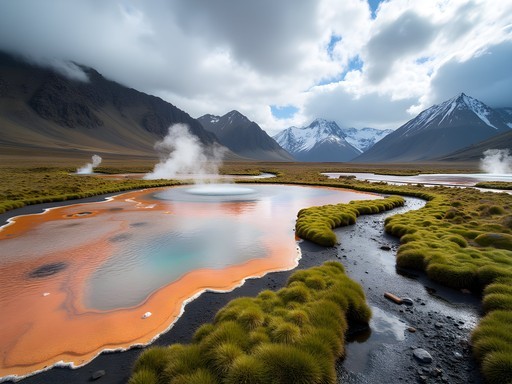
Hengill Geothermal Area: The Hidden Alpine Alternative to Geysir
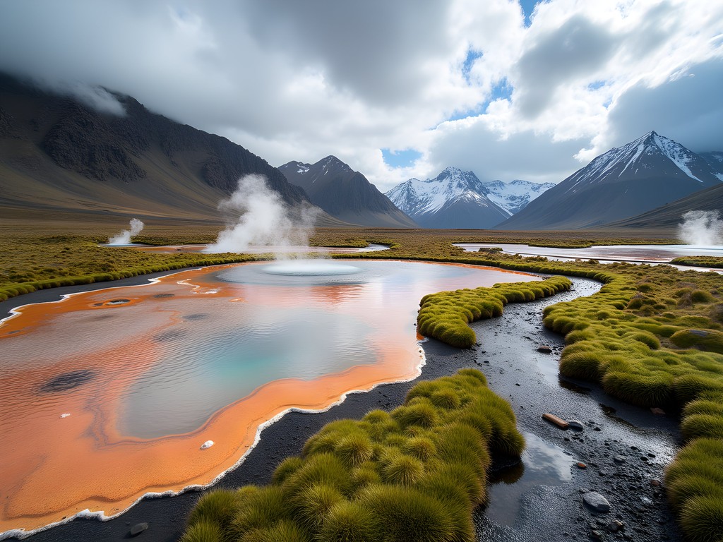
While tourists flock to the predictable eruptions of Strokkur geyser, I spent a challenging but rewarding day hiking the Hengill volcanic area, an active geothermal landscape that offers a more immersive experience with fewer crowds. The 18 km circular route from Hellisheiði Power Plant through the Reykjadalur valley presents technical terrain with nearly 800m of elevation gain, but rewards hikers with steaming fumaroles, multicolored mineral deposits, and hot springs you can actually bathe in—all without the tour bus crowds.
The trail begins deceptively easy but quickly ascends into alpine territory with loose scree and occasional scrambling sections. Having tackled similar terrain in the Canadian Rockies, I was prepared with my trusty trekking poles which proved invaluable on the steep descents and stream crossings.
The highlight came midway through the hike when I discovered a secluded hot spring creek where the temperature gradually increases as you move upstream. After checking with my thermometer, I found a perfect 39°C (102°F) spot to soak my hiking-weary muscles while gazing across the valley at the steam vents dotting the mountainside—a far cry from the shoulder-to-shoulder experience at the Blue Lagoon.
What makes this hike special is the combination of alpine challenge and geothermal wonder. The constantly changing landscape—from mossy lava fields to rocky mountain passes to steaming valleys—creates a microcosm of Iceland's diverse terrain in a single day hike.
💡 Pro Tips
- Start early (before 8 am) to ensure you have time for a hot spring soak mid-hike
- Pack quick-dry towel and swimwear for the natural hot springs
- The eastern section has limited trail markings—GPS navigation is essential
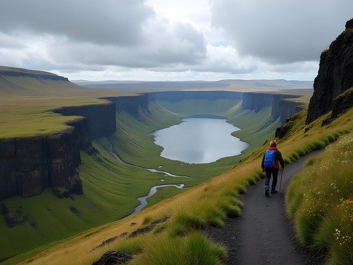
The Þingvellir Highland Traverse
Þingvellir National Park is justifiably famous as the site where the North American and Eurasian tectonic plates visibly separate and where Iceland's first parliament was established. Most visitors stick to the wooden boardwalks along the main fault line, but my manufacturing background has taught me to look for the less obvious, more efficient paths—in this case, a spectacular highland traverse that provides context for the geological formations below.
The 14 km one-way route begins at the official visitor center but immediately climbs away from the crowds to the highland plateau above the rift valley. The trail is marked with occasional cairns but requires confident navigation skills. What struck me immediately was the dramatic perspective—from above, you can clearly see the massive fissures and fault lines that are less apparent from within the valley.
The terrain alternates between exposed rocky sections and delicate alpine meadows filled with Arctic wildflowers. In late June, I hiked through patches of mountain avens, Arctic thyme, and moss campion that transformed the otherwise austere landscape into a subtle tapestry of whites, purples, and pinks.
The final descent brings you to Lake Þingvallavatn's northern shore, where arrangements for pickup are necessary (I scheduled a local taxi from Laugarvatn, as public transportation options are limited from this endpoint).
What makes this traverse special is the profound solitude—despite hiking on a clear summer day in high season, I encountered only two other hiking parties over seven hours. The silence allows for a deeper connection with this historically and geologically significant landscape than possible on the crowded main paths.

💡 Pro Tips
- Arrange transportation from the endpoint in advance—cell service is unreliable
- The route is exposed with no shelter—only attempt in good weather
- Bring binoculars to spot Arctic foxes and nesting birds on the cliffs

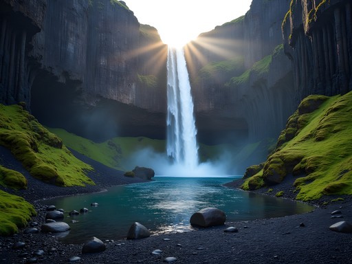
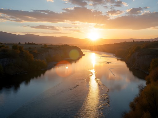
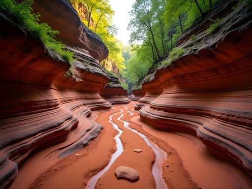
Beyond Gullfoss: The Hvítá River Canyon Trek
While thousands daily visit the viewing platforms at Gullfoss waterfall, few realize that the river feeding this famous cascade cuts through a spectacular canyon accessible via a challenging but rewarding full-day hike. As a production manager accustomed to seeing beyond the obvious to identify hidden efficiencies, I was drawn to this less-traveled path that delivers a more complete understanding of Iceland's hydrology.
The 16 km out-and-back route begins inconspicuously from the Gullfoss parking area, heading upstream along the Hvítá river. The first kilometer follows a faint sheep path before the trail becomes more established as it enters the canyon. The terrain is demanding—requiring several river crossings where the water shoes I packed proved invaluable. Summer water levels typically reach mid-thigh at the deepest crossing points, with surprisingly strong currents.
What makes this hike exceptional is the progression of the landscape. The canyon gradually narrows and deepens, revealing layer upon layer of ancient lava flows in its walls. About 6 km in, you'll discover a series of smaller but more intimate waterfalls that few tourists ever see, with perfect natural pools for a (very) brief dip if you're brave enough to face the glacier-fed waters.
The ecological transitions along the route are fascinating—from the windswept plateau near the parking lot to the sheltered microclimate within the canyon where Arctic wildflowers and dwarf birch create surprising pockets of color and life.
This hike demands proper preparation. The weather can change dramatically, and the canyon offers few exit points. I monitored conditions carefully and carried my emergency shelter as a precaution against Iceland's notoriously changeable weather.

💡 Pro Tips
- Check with local rangers about water levels before attempting river crossings
- Start by 9 am at the latest to ensure completion before evening
- Pack a complete change of clothes in a waterproof bag for after the river crossings
Logistics: Accommodation and Supplies
The key to successfully hiking Iceland's Golden Circle region is strategic planning—something my manufacturing career has prepared me well for. Accommodation options vary widely, but I've found tremendous value in family-run guesthouses around Selfoss and Laugarvatn that cater to outdoor enthusiasts rather than tour groups.
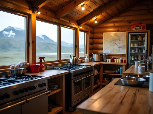
On this trip, I stayed at Héraðsskólinn Historic Guesthouse in Laugarvatn, a converted boarding school with dormitory-style and private rooms that attracts serious hikers. The communal kitchen allowed me to prepare trail lunches and dinners, significantly reducing costs in a country where restaurant meals easily exceed $30 for simple fare. The guesthouse also maintains a hiker's exchange shelf where guests leave unused supplies—I benefited from free stove fuel left by previous guests.
For supplies, the Krónan supermarket in Selfoss offers the best selection and prices for trail food. I stocked up on local flatbread, smoked lamb, and skyr (Icelandic yogurt)—high-energy foods that withstand a day in a backpack.
Gear considerations for Iceland's mountain trails are serious business. Even in summer, weather conditions change rapidly. I layer with merino wool base layers, a reliable mid-layer fleece, and my essential rain shell which has protected me through unexpected mountain storms from Colorado to the Alps. The waterproof breathable membrane has proven its worth repeatedly in Iceland's combination of precipitation and wind.
For footwear, the volcanic terrain demands sturdy hiking boots with aggressive tread patterns. After three Iceland trips, I've found that quick-drying materials are more practical than full waterproofing, as your feet will inevitably get wet during stream crossings.

💡 Pro Tips
- Book guesthouses with kitchen access to save 50-60% on food costs
- The Vinbudin state alcohol store in Selfoss has limited hours—plan accordingly if you want evening beverages
- Pack microspikes even in summer—unexpected snow patches remain on higher trails
Final Thoughts
Iceland's Golden Circle deserves its reputation, but the true alpine magic happens when you step beyond the designated viewpoints and into the surrounding mountains. As a business traveler who's learned to maximize limited time in extraordinary places, I've found these trails offer the perfect balance of challenge, solitude, and connection to Iceland's geological wonders. Whether you're extending a Reykjavík conference as I did or planning a dedicated hiking trip, these routes transform the Golden Circle from a tourist checklist into a profound mountain experience. The preparation demands are significant, but the rewards—having geothermal hot springs entirely to yourself or witnessing the midnight sun cast shadows across ancient lava fields—create the kind of authentic travel memories that no tour bus can deliver.
✨ Key Takeaways
- Public transportation can effectively connect most Golden Circle hiking trails with proper planning
- The summer hiking season (mid-June through August) offers the most accessible conditions for alpine trails
- Mountain huts require advance booking but provide strategic overnight options for multi-day hikes
- Weather preparedness is essential—conditions in Iceland's highlands change rapidly even in summer
📋 Practical Information
Best Time to Visit
Mid-June through August for optimal hiking conditions
Budget Estimate
$1,500-2,000 for one week including accommodation, food, and transportation
Recommended Duration
7 days (2 days for traditional sights, 5 days for mountain trails)
Difficulty Level
Challenging

Comments
dreamstar9069
Thanks for sharing! Definitely adding these to my itinerary.
islandchamp
Really cool! Didn't know about these trails
islandlife
Going there next month! Can you do these hikes without a guide?
Abigail Matthews
Yes! The trails I mention are all well-marked. Just download offline maps and check weather before you go.
Sage Dixon
Yes! The Hvítá River Canyon trek is criminally underrated. I did this last summer and had the entire trail to myself while literally thousands of people were crammed at the Gullfoss viewing platform a few kilometers away. The perspective you get from below the falls is just stunning. Fair warning though - the descent into the canyon is pretty steep and can be slippery. I was really glad I had my trekking poles with me. The scramble back up after a full day had my legs burning! Worth every step though.
photonomad
How long did the canyon hike take you?
Sage Dixon
About 5 hours round trip with lots of photo stops. Could probably do it in 3-4 if you're moving steadily.
Taylor Moreau
Excellent post, Abigail. I've been advocating for years that travelers should venture beyond the standard Golden Circle route. The Hvítá River Canyon trek you mentioned is particularly spectacular - I covered it in my Nordic hiking series last year. One additional tip for readers: if you're doing multiple day hikes in the highlands, invest in proper waterproof hiking boots. The terrain can be quite boggy even in summer, and the volcanic rock is unforgiving on standard trainers.
hikingvibes
Good call on the boots! Any specific recommendations?
wandergal
Love the photos! That canyon shot is incredible.
tripguide1882
Love the photos! Adding this to my list
hikingvibes
This is exactly what I needed! Did the Golden Circle last summer and honestly felt a bit underwhelmed with all the crowds. The Hengill area sounds incredible - how difficult would you say those trails are? I'm reasonably fit but not like hardcore mountaineer level haha. Also curious about weather in late May, thinking of going back to do these hikes properly this time.
islandchamp
Late May is good! Still some snow on higher trails tho
Abigail Matthews
The Hengill trails are moderate - definitely doable if you're reasonably fit! Late May can be unpredictable weather-wise, so just pack layers and waterproofs. The trails are well-marked and you'll have way fewer people than the main stops.
dreamstar9069
Going in May! Is it too early for these trails?
Sage Dixon
May should be fine but expect snow patches at higher elevations. Check SafeTravel.is before you go!
Fatima Sims
Abigail, this brings back memories! I did the Hengill area back in 2019 and it was absolutely magical. We started early morning from Nesjavellir and the steam rising from the geothermal vents with the sunrise was surreal. One tip I'd add - the weather can turn SO quickly up there. We went from sunshine to sideways rain in about 15 minutes. Also, the trail markers aren't always obvious once you get into the highland sections, so having offline maps downloaded was crucial. Did you camp up there or day hike it?
photonomad
How hard is the Hengill trail? I'm moderately fit but not super experienced.
Fatima Sims
I'd say moderate! The elevation gain is steady but not too steep. Main challenge is the terrain - lots of loose volcanic rock. Good boots are essential.
Venture X
Premium card with 2X miles, $300 travel credit, Priority Pass