


Disclosure: This article contains affiliate links. We may earn a commission from purchases at no extra cost to you, which helps our travel content.
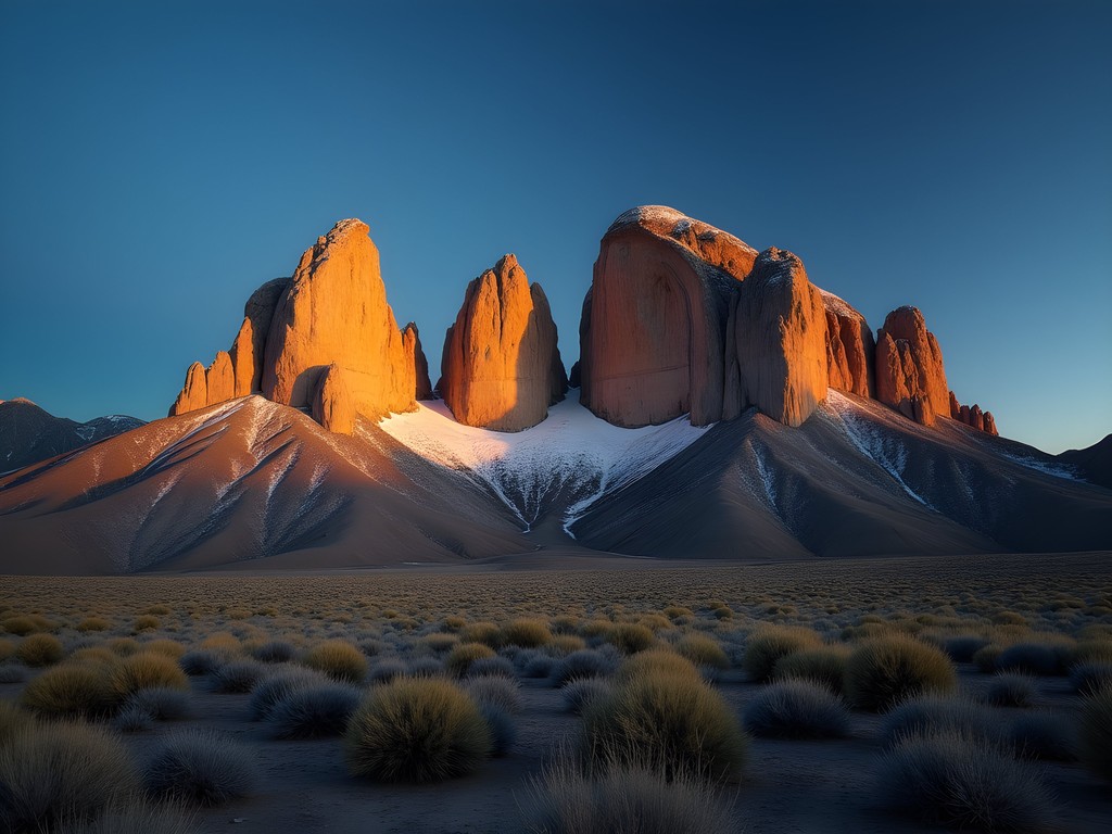
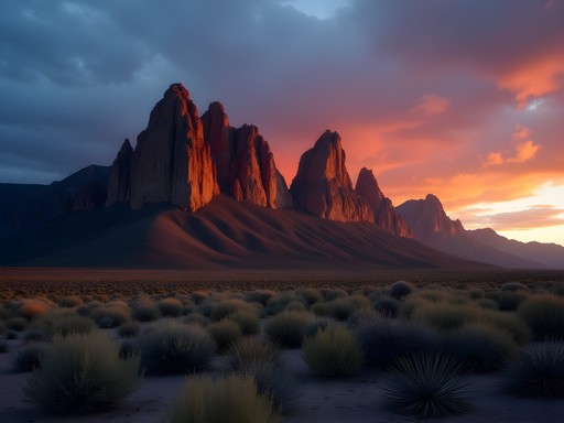
The first time I saw the Organ Mountains rising abruptly from the Chihuahuan Desert floor, I was reminded of nature's engineering prowess. These jagged granite spires—named for their resemblance to pipe organs—represent a geological masterpiece some 32 million years in the making. As someone who's hiked across three continents, I can confidently say this national monument offers some of North America's most dramatic and underappreciated terrain, all within a surprisingly accessible weekend adventure framework.

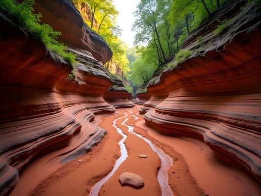
The Geological Marvel of the Organ Mountains
From an engineer's perspective, the Organ Mountains represent a fascinating case study in volcanic formation and erosion dynamics. These mountains weren't simply pushed up from the earth—they're the exposed magma chambers of an ancient volcanic field, revealed through millions of years of erosion. The prominent 'needles' that give the range its name reach heights of 9,000 feet, creating a 4,000-foot elevation differential from the desert floor.
During my first reconnaissance hike along the Dripping Springs Trail, I measured a temperature drop of nearly 15°F between the desert basin and the mountain slopes—a microclimate effect that creates surprisingly diverse ecological zones within short distances. This makes fall the perfect season to visit; daytime temperatures hover in the comfortable 65-75°F range, while the characteristic New Mexican blue skies provide exceptional visibility across the basin.
What makes these mountains particularly special is how they stand in isolation, rising dramatically from the surrounding landscape rather than forming part of a continuous range. It's a testament to the power of geological forces and creates a visual impact that even the most technically-minded hiker can appreciate on a purely aesthetic level.
💡 Pro Tips
- Bring a geological field guide to appreciate the unique formations you'll encounter
- The mountains are visible from almost everywhere in Las Cruces—use them as a natural compass
- Temperature differences between desert floor and mountain slopes can exceed 15°F—layer accordingly
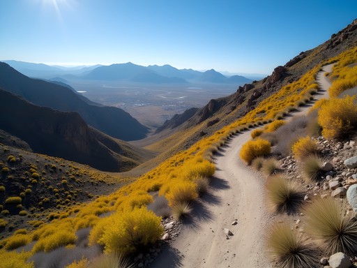
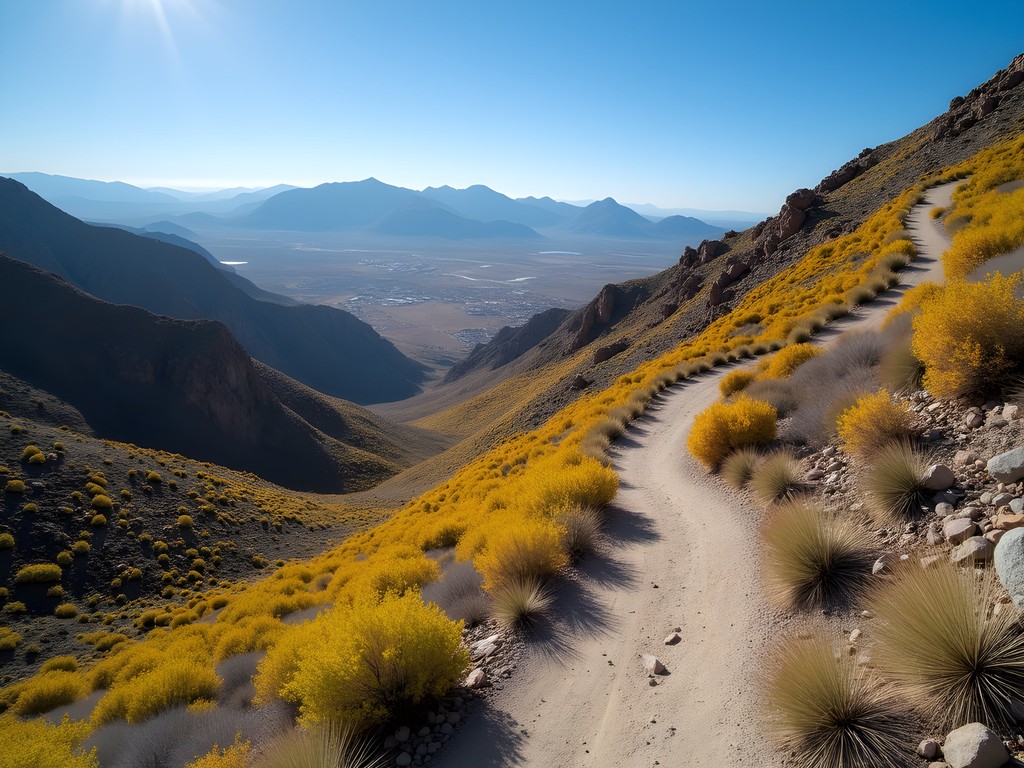
Baylor Pass Trail: The Engineering-Minded Approach
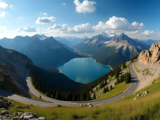
As someone who appreciates efficient design, I'm drawn to the Baylor Pass Trail for its remarkable engineering. This 4.4-mile one-way route (8.8 miles round-trip) offers the most direct traverse through the range, connecting the east and west sides through a natural saddle at 6,780 feet. With approximately 1,800 feet of elevation gain, the trail presents a moderate challenge that rewards hikers with panoramic views in both directions.
The western approach begins in desert scrubland dominated by creosote and ocotillo. I tracked my ascent using my trusty GPS hiking watch, which recorded a steady 9.7% average grade—steep enough to elevate the heart rate but engineered with enough switchbacks to remain sustainable. The trail's construction demonstrates thoughtful water management, with strategic drainage channels that minimize erosion while preserving the natural terrain.
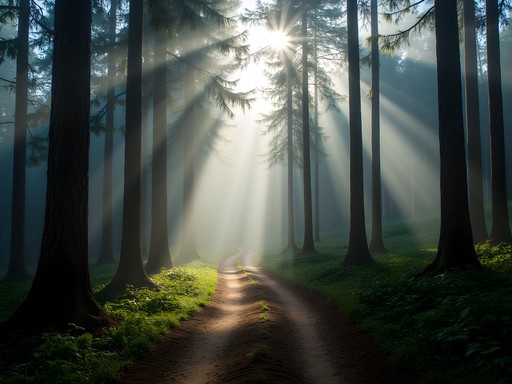
At the pass itself, the environmental transition becomes most apparent. The eastern slopes receive significantly more moisture, supporting juniper and piñon pine woodlands. This microclimate variation within a single hike exemplifies why these mountains host over 870 plant species—remarkable biodiversity for such a compact range.
During my October hike, I encountered only three other hikers over five hours, making this an ideal route for solitude-seeking solo travelers who appreciate both natural beauty and intelligent trail design.
💡 Pro Tips
- Start from the west side for a more gradual ascent profile
- Carry at least 3 liters of water—the exposed sections can be deceptively dehydrating even in cooler weather
- Allow extra time at the pass to appreciate the contrasting views of the Tularosa Basin and Mesilla Valley
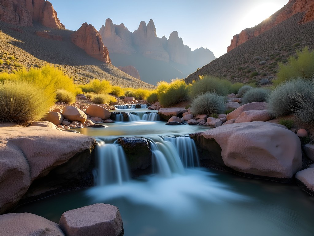
Soledad Canyon: Budget-Friendly Desert Immersion
For the budget-conscious weekend hiker, Soledad Canyon offers exceptional value with minimal resource investment. The Bar Canyon Loop (3.4 miles) and Soledad Canyon Trail (3.5 miles round-trip) provide accessible options with impressive scenery-to-effort ratios. Both trailheads are located just 15 minutes from Las Cruces, eliminating the need for extensive travel or accommodation costs.
What fascinates me about this area is the water resource engineering. Despite the arid environment, a spring-fed waterfall operates year-round in Soledad Canyon—a testament to the complex hydrogeology beneath the surface. During my fall visit, the waterfall was modest but persistent, creating a microhabitat for riparian species that contrast sharply with the surrounding desert.
I set out before dawn to capture the changing light conditions, packing my hiking headlamp which provided ample illumination for the pre-dawn approach. This timing strategy allowed me to observe the thermal dynamics of the canyon as it warmed, creating subtle air currents that wildlife seemed to navigate with precision.
The terrain here is surprisingly varied for a shorter trail system. Smooth sections of decomposed granite alternate with technical rocky passages, providing a sampling of the range's geological diversity without requiring specialized equipment or advanced skills. For those testing new hiking gear or techniques before more ambitious expeditions, these trails offer an ideal proving ground with minimal financial commitment.
💡 Pro Tips
- Visit on weekdays for maximum solitude—weekends can bring local families to the more accessible sections
- The seasonal waterfall is most impressive after monsoon rains (July-September), but flows year-round
- Bring cash for the $5 day-use fee at some trailheads (exact change recommended)

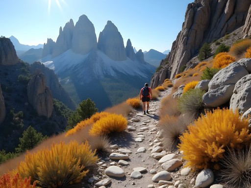
Aguirre Spring and The Needle: Technical Challenge for Solo Hikers
For those seeking a more technical challenge, the Pine Tree Trail (4.3-mile loop) and Needle Trail (4.5 miles one-way) from Aguirre Spring Campground offer significant elevation gain and more complex terrain. As a solo hiker with extensive mountain experience, I found these routes provided the perfect balance of accessibility and challenge.
The Needle Trail particularly stands out as an engineering marvel of trail construction. Ascending nearly 3,000 feet to the base of The Needle formation, the trail navigates through complex terrain with strategic use of natural features to maintain stability. Having hiked similar granite environments in the Sierra Nevada and Swiss Alps, I was impressed by how this trail achieves technical difficulty while remaining accessible to intermediate hikers.
For this more demanding route, proper gear becomes essential. My trekking poles proved invaluable on the steeper sections, providing stability and reducing impact on my knees during the descent. Additionally, I relied heavily on my trail map as cellular reception is unreliable in the more remote sections.
What makes these trails particularly suitable for solo hikers is the combination of challenge and safety. Despite the technical nature, the trails remain well-marked and receive enough traffic that help would be available in an emergency—though I always carry my satellite messenger when hiking alone in remote areas.

💡 Pro Tips
- Start the Needle Trail early (by 8 AM) to complete the round trip with ample daylight buffer
- The Aguirre Spring Campground makes an excellent base camp at just $7 per night
- High winds are common near the summit—bring a windproof layer even on calm days in the valley
Sustainable Exploration and Conservation Considerations
As both an engineer focused on sustainability and an outdoor enthusiast, I approach these landscapes with particular attention to their ecological vulnerability. The Organ Mountains-Desert Peaks National Monument was only established in 2014, representing a recent recognition of this ecosystem's importance. The area hosts several endemic species found nowhere else on Earth, including the Organ Mountains evening primrose and the Organ Mountains giant hissing cockroach (admittedly less charming but equally important ecologically).
Water conservation becomes particularly critical in this desert environment. I've adopted the practice of carrying a water filter to utilize natural water sources when available, reducing the need to carry excessive water weight while ensuring proper hydration. This approach minimizes impact while maximizing safety.
Trail erosion presents another sustainability challenge in this fragile desert ecosystem. I've observed how seasonal monsoon rains can dramatically reshape trail surfaces, making proper technique essential. Staying centered on established paths and avoiding social trails helps preserve the landscape's integrity for future visitors.
For overnight adventures, I recommend the bear canister not for bears (which are rare in this ecosystem) but to protect food from the numerous small mammals and to prevent microtrash dispersal that can harm wildlife. This leave-no-trace approach ensures we're minimizing our footprint on this remarkable landscape.

💡 Pro Tips
- Follow strict Leave No Trace principles—pack out all waste including organic material like apple cores and orange peels
- Stay on established trails to protect the fragile desert crust that can take decades to recover from footprints
- Consider visiting during weekdays to reduce cumulative impact on popular trails
Final Thoughts
The Organ Mountains-Desert Peaks National Monument represents a perfect synthesis of what I seek in weekend adventures: technical challenge, environmental diversity, budget accessibility, and relative solitude. As an engineer, I appreciate how these mountains demonstrate nature's structural principles—the granite spires standing in defiance of gravity through perfectly balanced forces and materials.
What makes this destination particularly valuable for solo travelers is the combination of accessibility and wilderness experience. Within 30 minutes of Las Cruces (a city with affordable accommodation and amenities), you can be standing in terrain that feels genuinely remote and untamed.
As climate patterns shift across North America, these desert mountain ecosystems provide important insights into resilience and adaptation—lessons I carry back to my renewable energy work. I encourage fellow adventure-minded travelers to explore these landscapes with both technical curiosity and environmental reverence. The Organ Mountains aren't merely a backdrop for adventure; they're a complex system worthy of our understanding and protection.
✨ Key Takeaways
- The Organ Mountains offer world-class hiking with minimal crowds just minutes from Las Cruces
- Fall provides the optimal balance of comfortable temperatures, clear visibility, and accessible trails
- Budget-conscious solo travelers can experience remarkable terrain without extensive financial investment
📋 Practical Information
Best Time to Visit
September through November
Budget Estimate
$150-300 for a weekend (including accommodation, food, and transportation)
Recommended Duration
2-3 days
Difficulty Level
Moderate

Comments
roampro
Going in March, will it still be too hot?
citylife
March is perfect! That's prime hiking season there. You'll have great weather
Megan Martin
Excellent writeup, Brian. I appreciate your engineering perspective on the trail construction at Baylor Pass - I hadn't considered the switchback design in that context before. For business travelers passing through El Paso, the Organ Mountains make an excellent half-day excursion. I've recommended Aguirre Spring to several colleagues who had layovers, and the proximity to Las Cruces (about 20 minutes) makes it very accessible. The camping facilities at Aguirre Spring are also well-maintained if anyone wants to extend their visit.
citylife
YES!! I hiked The Needle last October and it was INCREDIBLE! Definitely the most challenging hike I've done in New Mexico but so worth it. The views from the top are absolutely mind-blowing. Pro tip: go in fall or early spring because summer is brutal. Also the scrambling near the top is no joke - wear proper hiking boots with good ankle support!
Stephanie Romano
We took our kids (8 and 11) to Soledad Canyon last spring and it was perfect for families! The trail is relatively flat and the canyon walls kept us shaded for most of the hike. We packed a picnic and spent about 3 hours there total. My daughter loved exploring the rock formations. Just be aware there's no water on the trail, so we brought our hydration packs which made it so much easier than carrying bottles. The visitor center at the base has clean restrooms which was a lifesaver with kids!
roampro
good to know about the water situation!
bluemood
How hard is Baylor Pass for someone who doesn't hike much? The photos look amazing but I'm kinda nervous about the elevation
Megan Martin
Baylor Pass is moderate but doable if you pace yourself. Start early to avoid heat and bring plenty of water. The elevation gain is gradual for most of it.
bluemood
thanks! that helps a lot
wanderlustblogger
Those spires look insane! Adding to my list
backpackperson
Going next month! Can't wait.
Jean Wells
Brian, excellent breakdown of the trail options. I appreciate your engineering perspective on the Baylor Pass switchbacks - that's exactly the kind of detail that helps with route planning. I hiked solo there in March 2024 and found the exposure on The Needle quite significant for anyone uncomfortable with heights. The granite formations are geologically fascinating, similar to some formations I've studied in the Japanese Alps but with distinctly different weathering patterns due to the arid climate. One consideration: cell service is nonexistent in most canyons, so offline maps are essential.
vacationone
Did Aguirre Spring last April and it was perfect weather. The wildflowers were insane - ocotillo blooming everywhere. Camped at the campground there which was pretty basic but clean. Only $7/night I think. The Needle trail kicked my butt but worth every step. Pro tip: there's basically zero shade so plan accordingly. Also saw some bighorn sheep near the upper ridge which was incredible.
escapevibes
Bighorn sheep?? That's so cool!
escapevibes
How much water should I bring for Soledad Canyon? Planning my first desert hike and kinda nervous about the heat.
backpackperson
minimum 3 liters, more if it's summer. desert doesn't mess around
vacationone
Agree with backpackperson. Also start super early, like 6am. Makes a huge difference.
Venture X
Premium card with 2X miles, $300 travel credit, Priority Pass