


Disclosure: This article contains affiliate links. We may earn a commission from purchases at no extra cost to you, which helps our travel content.
The first time I stood atop Mount Sentinel overlooking Missoula, my nurse's instinct to monitor vital signs kicked in – but it was my own heart racing from the panoramic beauty that caught my attention. Having spent countless nights observing stars during hospital breaks, finding this perfect combination of accessible trails, dark skies, and diverse ecosystems felt like discovering medicine for the soul. As someone who's hiked everywhere from Patagonia to the Australian Outback, I can confidently say Missoula's mountains offer something truly special for families seeking both adventure and educational opportunities in nature.

Day 1-2: Acclimating with Beginner-Friendly Trails
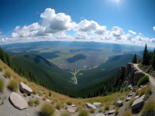
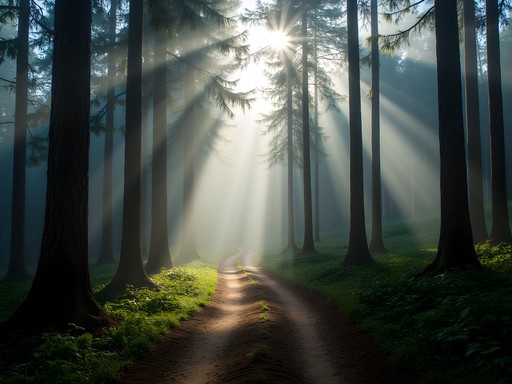
When traveling with kids or those new to mountain terrain, I've learned that a gradual introduction prevents both physical and emotional meltdowns. Begin your Missoula adventure with the 'M' Trail on Mount Sentinel – a 3/4 mile switchback path with 620 feet of elevation gain that rewards hikers with expansive valley views. The geological formations visible from this vantage point tell a 12,000-year story of ancient Lake Missoula.
On day two, venture to Greenough Park, a 42-acre urban sanctuary along Rattlesnake Creek with flat, shaded trails perfect for observing riparian ecosystems. I've spent hours here with my daughter identifying native plants and watching osprey dive for trout. These gentle introductions allow your body to adjust while building confidence for more challenging hikes.
Before heading out, I always prepare a small day pack with essentials. My hydration reservoir has been indispensable for keeping everyone hydrated without constant water bottle refills. For families with younger children, I recommend packing a field microscope to transform an ordinary hike into a scientific expedition by examining leaf structures and insect life up close.

💡 Pro Tips
- Start early morning (before 9am) to avoid afternoon thunderstorms common in summer
- The 'M' Trail has benches at switchbacks – perfect rest spots for discussing the valley's formation with kids
- Greenough Park has restrooms and picnic areas, making it ideal for a packed lunch break
Day 3-4: Intermediate Adventures in the Rattlesnake National Recreation Area
The Rattlesnake National Recreation Area offers the perfect progression in difficulty while showcasing some of Montana's most diverse ecosystems. Begin with the Main Rattlesnake Trail to Stuart Peak – you don't need to complete the entire 16-mile round trip to experience its beauty. The first 4 miles provide spectacular creek crossings, dense pine forests, and occasional wildlife sightings including white-tailed deer and black bears.
During my last visit, we hiked to Strawberry Lake (a 7-mile round trip) and witnessed three distinct weather systems collide above the ridge – a meteorological spectacle that had my weather-enthusiast heart racing. The trail gains elevation gradually, making it manageable for older children and adults with moderate fitness levels.
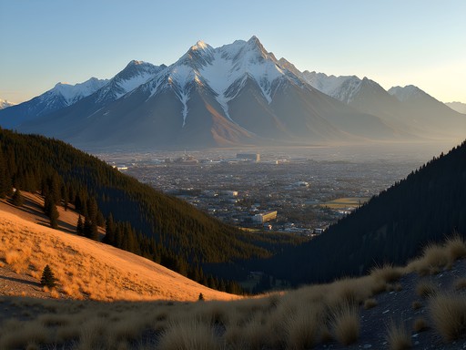
For day four, I recommend the Ch-paa-qn Peak Trail (formerly known as Squaw Peak). This 8-mile round trip with 2,100 feet of elevation gain offers subalpine meadows bursting with wildflowers in July and August. The 360-degree summit views extend to the Bitterroot Mountains and Mission Range – perfect for teaching kids about mountain formation and identifying distant peaks.
Safety becomes increasingly important at these elevations. My satellite messenger provides peace of mind when cell service disappears. And after years of trial and error, I've found nothing beats a quality pair of trekking poles for maintaining stability on steeper sections while reducing knee strain on descents.

💡 Pro Tips
- Check trail conditions at the Rattlesnake Recreation Area trailhead – stream crossings can be high in early summer
- Pack layers! Temperature variations of 20+ degrees are common between valley floor and higher elevations
- Bring bear spray and know how to use it – black bears are common in the Rattlesnake area
Day 5-6: Advanced Trails and Alpine Experiences
For experienced hikers seeking greater challenges, days five and six elevate both the difficulty and the rewards. The Blodgett Canyon Overlook Trail in the Bitterroot Mountains (about 45 minutes from Missoula) offers a moderately challenging 3-mile round trip hike with breathtaking views of a glacially carved canyon that rivals Yosemite in grandeur. The trail's exposure and steeper sections demand proper footwear and attention to footing.
As a nurse who's treated countless blisters and ankle injuries, I can't emphasize enough the importance of proper footwear. After trying numerous brands, my hiking boots have proven themselves on everything from scree fields to wet granite slabs.
Day six brings the crown jewel: Lolo Peak. This challenging 14-mile round trip with 3,800 feet of elevation gain takes you through multiple ecological zones to an alpine summit offering views into Idaho and across much of western Montana. The trail passes Carlton Lake, providing a perfect lunch spot and swimming opportunity (though be prepared for bracingly cold water).
The meteorological patterns visible from Lolo Peak are fascinating – you can often see weather systems developing and moving through different valleys simultaneously. During my last summit, we witnessed three distinct thunderstorms tracking across different regions while standing in perfect sunshine – a powerful reminder of mountain weather's localized nature.

💡 Pro Tips
- Start Lolo Peak hikes no later than 7am to avoid afternoon thunderstorms and ensure adequate return time
- The final approach to Lolo Peak involves some route-finding – download offline maps before your hike
- Pack microspikes even in summer – snow patches can persist on north-facing aspects into July

Day 7: Recovery and Stargazing at Blue Mountain Observatory
After six days of progressive hiking, I always recommend a gentler finale that combines light activity with one of Missoula's hidden treasures – its dark skies. The Blue Mountain Nature Trail offers an easy 1.5-mile loop perfect for tired legs while still delivering beautiful forest immersion and wildlife viewing opportunities.
But the real magic happens after sunset. Blue Mountain Observatory, operated by the University of Montana, sits at 6,300 feet and offers public stargazing events throughout summer (check their schedule in advance). As someone who's found solace in the night sky during countless hospital night shifts, I can attest that few experiences compare to seeing Saturn's rings or Jupiter's moons through a quality telescope while an astronomer explains what you're viewing.
The plateau location provides exceptional viewing conditions away from city light pollution. I've witnessed meteor showers, tracked satellites, and identified constellations from this vantage point that have left both adults and children speechless with wonder.
For nighttime comfort, I never visit without my rechargeable headlamp which features a red light mode that preserves night vision. And since mountain evenings get chilly even in summer, my packable down blanket has created countless cozy stargazing setups while adding minimal weight to my pack.

💡 Pro Tips
- Bring binoculars even if attending an observatory event – they're perfect for scanning the Milky Way while waiting for telescope turns
- Temperatures drop rapidly after sunset – pack extra layers beyond what daytime temperatures suggest
- Download a star chart app to your phone for self-guided constellation identification
Final Thoughts
Missoula's mountain trails have offered my family not just physical challenges, but living laboratories where weather patterns, geological forces, and celestial wonders become tangible educational experiences. What makes this region truly special is its accessibility – within a single week, hikers of all abilities can progress from gentle nature walks to challenging alpine summits, all while experiencing Montana's legendary big sky and pristine wilderness.
As both a healthcare professional and father, I've found few destinations that combine physical wellness opportunities with mental rejuvenation so perfectly. The gradual progression outlined in this itinerary allows families to build confidence while creating memories that transcend typical vacations. Whether you're identifying constellations from Blue Mountain Observatory or watching thunderheads build over distant peaks, Missoula's mountains offer constant reminders that we're part of something much larger than ourselves.
I encourage you to use this guide as a framework rather than a rigid schedule – allow weather conditions, energy levels, and unexpected discoveries to shape your journey. The mountains have been here for millions of years; they invite us to slow down and experience them on their terms, with curious minds and open hearts.
✨ Key Takeaways
- Start with easier trails and progressively build to more challenging hikes to prevent injuries and build confidence
- Missoula offers exceptional educational opportunities combining geology, meteorology, and astronomy in one destination
- Summer afternoons frequently bring thunderstorms – plan morning hikes and monitor weather patterns carefully
- The combination of mountain trails and dark sky viewing makes Missoula ideal for families seeking both adventure and educational experiences
📋 Practical Information
Best Time to Visit
Mid-June through mid-September
Budget Estimate
$1,200-1,800 for a family of four for one week (excluding flights)
Recommended Duration
7 days minimum, 10 days ideal
Difficulty Level
Progressive From Easy To Challenging


Comments
Bryce Diaz
Nathan, this resonates so much with my own Missoula experience. That moment on Mount Sentinel - I know exactly what you mean. I was there during a September afternoon when the larch trees were turning gold, and the whole valley looked like it was on fire with color. What struck me most was how accessible these trails are. You can literally walk from downtown Missoula to the M Trail trailhead. No long drives, no complicated logistics. Just you and the mountain. The progression you've laid out here is perfect - I've seen too many visitors try to tackle the advanced trails on day one and end up miserable. That acclimation period isn't just smart, it's essential. Did you catch any of the wildlife up in Rattlesnake? I had a moose encounter that still gives me chills.
islandmaster
Blue Mountain Observatory tip - the stargazing is incredible but it gets COLD at night even in summer. Learned that the hard way. Also the road up can be rough, high clearance vehicle recommended.
Bryce Diaz
Yes! I brought my puffy jacket on what I thought would be a warm August night and still froze. Montana nights are no joke.
islandmaster
exactly. but so worth it
escapezone
how hard is the rattlesnake area really? never hiked montana before
Bryce Diaz
The Rattlesnake has options for everyone! I spent three days there last fall, and the main corridor trail is pretty mellow - wide, well-maintained, perfect for easing into Montana hiking. But here's what I learned: the elevation gain sneaks up on you. Even the "intermediate" trails can feel advanced if you're coming from sea level. Start early, bring way more water than you think you need, and give yourself that acclimation time Nathan mentions. The views up Stuart Peak made every huffing breath worth it.
escapezone
thanks! coming from florida so yeah sea level lol
Savannah Walker
Nathan, this is such a well-planned itinerary! I love that you built in a recovery day at the end. I did a similar trip in Missoula two years ago and made the mistake of going hard all seven days - by day 6 my knees were screaming. The Blue Mountain Observatory is such a perfect way to end the week. The stargazing there is phenomenal because there's almost zero light pollution. I actually met a ranger who gave us an impromptu lesson on constellations. Did you get to see the Milky Way clearly when you were there?
roamninja
Did the Rattlesnake area last summer and it was incredible. Saw a moose on the trail near Stuart Peak! One tip - bring way more water than you think you need. The elevation gain sneaks up on you and there aren't many water sources once you're up high. Also the wildflowers in July are insane. Great guide Nathan!
cooltime
whoa a moose! did you get pics?
roamninja
yeah but from way back lol. gave it plenty of space. they're huge up close
cooltime
Going there next spring! How crowded is Mount Sentinel on weekends?
Savannah Walker
Mount Sentinel gets pretty busy on Saturday mornings - locals love their sunrise hikes! I'd recommend going midweek or hitting the trail before 7am on weekends. The M trail is the most popular route but totally worth it for those views.
cooltime
awesome thanks!
greenqueen157
Has anyone done the Blue Mountain Observatory stargazing? Wondering if it's worth planning our trip around their open house nights or if the regular night sky views are good enough from other spots?
Marco Flores
The open house is definitely worth it! They have telescopes set up and astronomers explaining what you're seeing. But if you can't make those dates, the regular views from Blue Mountain are still incredible on clear nights.
wanderlustninja
Love the recovery day idea! Always skip that and regret it later.
wanderlustmaster
Those Day 5-6 advanced trails look intense! Anyone done Ch-paa-qn Peak?
greenqueen157
Did it last summer! Tough but worth it. Bring more water than you think you need and start EARLY. The last mile is no joke but the views are incredible.
Sophia Gomez
Nathan, I can't thank you enough for this guide! I was in Missoula for a conference last month and used your Day 1-2 recommendations during my limited free time. The Kim Williams Nature Trail was perfect after sitting in sessions all day. What surprised me most was how accessible these trails are from downtown - I literally walked from my hotel to the trailhead! I found my hiking poles essential on the steeper sections of the 'M' Trail. For business travelers with limited time, I'd add that sunrise hikes are magical and still get you back in time for morning meetings!
Venture X
Premium card with 2X miles, $300 travel credit, Priority Pass