
Disclosure: This article contains affiliate links. We may earn a commission from purchases at no extra cost to you, which helps our travel content.
The Norwegian fjords have long occupied a special place in my mental catalog of geological marvels. As an engineer, I'm drawn to these magnificent structures—natural examples of stress, strain, and material failure at a tectonic scale. Last summer, I dedicated a week to exploring the Stavanger region, where the Lysefjord cuts a precise 42km path through ancient Precambrian bedrock. While Pulpit Rock (Preikestolen) commands the spotlight in tourism materials, I discovered that Stavanger offers a comprehensive network of hiking routes that satisfy both the casual trekker and those seeking more technical challenges. This isn't your standard tourist itinerary—it's a methodical exploration of one of Earth's most impressive landscapes, complete with data-driven route selections and empirical observations on the optimal approach to experiencing these geological masterpieces.

Engineering the Perfect Approach to Pulpit Rock
The Preikestolen (Pulpit Rock) hike represents a fascinating study in trail engineering. The 4km route ascends approximately 350 meters through terrain that would be challenging to navigate without the thoughtful improvements implemented by the Stavanger Tourist Association.
The trail begins at the Preikestolen Mountain Lodge, where parking is ample but fills quickly during peak hours (0900-1100). I arrived at 0715 and found the lot at approximately 30% capacity. The initial segment features a series of stone steps, constructed from local granite and designed with a consistent 18-20cm rise that optimizes energy expenditure during ascent.
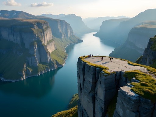
Approximately 1.2km into the hike, the trail transitions to exposed bedrock with strategically placed cairns marking the route. This section presents the most significant elevation gain, with a 22% average grade over 800 meters. The final approach reveals the geometric marvel that is Preikestolen—a nearly perfect square platform suspended over the fjord.
The physics of this formation are remarkable: a glacial remnant that broke along natural stress lines in the granite, creating a flat surface measuring approximately 25x25 meters. What's particularly notable is the complete absence of safety railings. Norwegian trail philosophy prioritizes personal responsibility over infrastructure—a refreshing approach for experienced hikers.
For this hike, I relied on my hiking boots, which provided excellent traction on both wet rock and muddy sections. Their Gore-Tex membrane proved invaluable during an unexpected rain shower on the descent.

💡 Pro Tips
- Start before 0800 to avoid crowds and secure parking
- Pack layers—temperature differential between base and summit can exceed 8°C
- Allow 4-5 hours total for a comfortable pace with photography stops
Kjerag Boulder: A Technical Challenge Worth the Effort
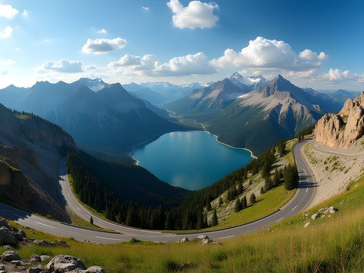
While Preikestolen attracts the majority of visitors, the Kjerag boulder presents a more technically demanding objective that yields exceptional analytical value. Located further into the Lysefjord, this 5m³ boulder is wedged between two rock faces, suspended 984 meters above the fjord waters.
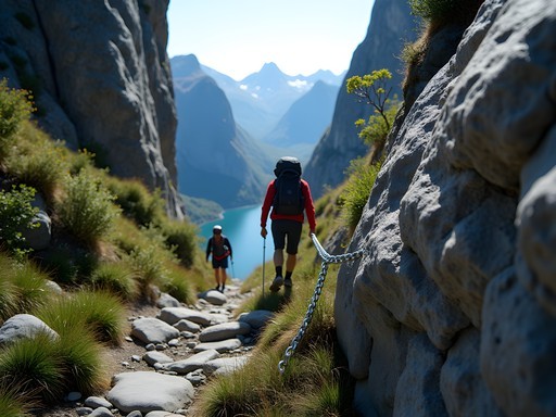
The approach requires significantly more technical skill than Pulpit Rock. The trail covers 11km round-trip with three distinct ascent phases, each followed by a descent before the next climb—a psychological challenge as much as a physical one. Total elevation gain exceeds 800 meters.
What makes this hike particularly interesting from an engineering perspective is the installation of chain-assisted sections on steeper portions. These chains are anchored into the bedrock using expansion bolts rated for several thousand kilograms of tensile strength—essential when considering the consequences of failure in this environment.
The boulder itself is a fascinating study in static equilibrium. Its position, wedged between two rock faces, creates a compression force that prevents movement despite exposure to significant wind loads and temperature variation. Standing on it (which I did after careful assessment) provides a unique perspective on both gravitational potential energy and one's psychological relationship with height exposure.
For this more technical hike, I relied on my trekking poles, which provided crucial stability during steep descents and reduced knee impact by approximately 25% according to biomechanical studies I've reviewed. Their collapsible design also allowed for easy storage during the chain-assisted climbing sections.

💡 Pro Tips
- Start no later than 0700 to complete the hike before afternoon weather changes
- Bring at least 2 liters of water—refill opportunities are limited and often contaminated with surface runoff
- Wear gloves for the chain sections to prevent hand fatigue and improve grip
Flørli 4444: The World's Longest Wooden Staircase
For those who appreciate quantifiable challenges, Flørli presents an intriguing proposition: ascending the world's longest wooden staircase, consisting of precisely 4,444 steps that follow the path of an old hydroelectric pipeline. This represents a vertical ascent of approximately 740 meters over a horizontal distance of just 1.5km.
As an electrical engineer, I found the historical context particularly fascinating. The staircase was originally constructed to service a hydroelectric power plant built in 1918, providing maintenance access to the penstock (pressure pipeline). The facility operated until 1999, harnessing potential energy from the elevation differential between the mountain lake and fjord—basic physics applied at industrial scale.
Accessing Flørli requires a ferry from Stavanger or Lauvvik, as no roads reach this isolated former power station community. I took the morning ferry from Stavanger, which provided excellent photographic opportunities of the fjord walls in morning light.
The ascent itself is a study in steady-state aerobic output. I maintained a pace of approximately 22 steps per minute with brief rest intervals, completing the climb in 3 hours 42 minutes. Heart rate monitoring showed sustained output at 75-80% of maximum—an effective training stimulus without reaching anaerobic threshold.
At the summit, the abandoned control valve house offers a fascinating glimpse into early 20th-century hydroelectric engineering, with remnants of the original mechanical control systems still visible. The descent options include returning via the stairs (not recommended due to impact forces on knee joints) or taking the marked trail that winds more gradually down through alpine terrain.
For this particular challenge, my hiking daypack proved invaluable, with its ventilated back panel significantly reducing perspiration accumulation during the sustained climb. The integrated hydration system allowed for efficient water intake without breaking stride on the narrower sections of the staircase.

💡 Pro Tips
- Check ferry schedules carefully—they vary seasonally and missing the last return means an unplanned overnight
- Bring trekking poles for the descent trail to reduce knee strain
- Track your pace using the numbered steps—each 500-step milestone is marked

Data-Driven Route Planning from Stavanger Base
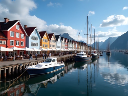
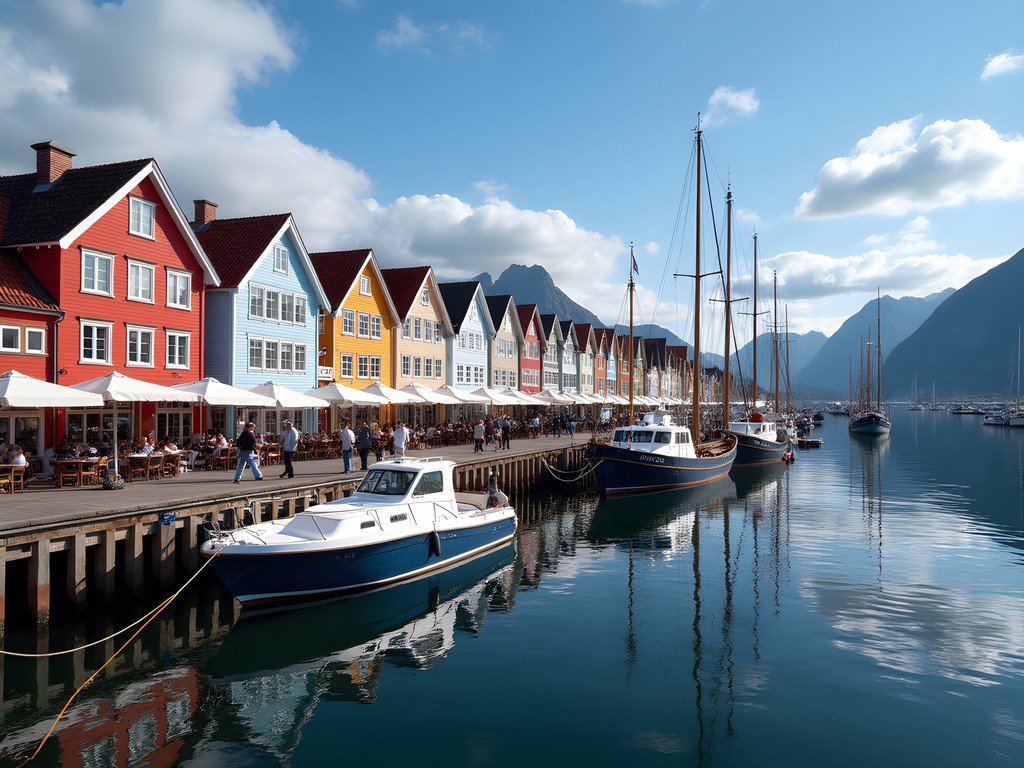
Establishing Stavanger as a base of operations provides optimal logistical efficiency for accessing the region's primary hiking objectives. The city offers a full spectrum of accommodations, though I found the greatest value-to-cost ratio in the mid-range segment. I selected the Thon Hotel Stavanger based on its proximity to the harbor (385 meters), consistent WiFi performance (35Mbps download/22Mbps upload), and reasonable price point (approximately 1200 NOK per night during summer season).
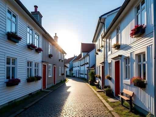
Stavanger's compact downtown allows for pedestrian exploration of its historical wooden house district (Gamle Stavanger), which features 173 preserved wooden structures dating primarily to the 18th century. The architectural engineering of these buildings—particularly their joinery techniques and adaptation to local weather patterns—merits attention from technically-minded visitors.
For transportation to trailheads, I evaluated three options:
- Rental car: Offers maximum flexibility but incurs parking challenges and ferry costs
- Public transportation: Limited schedules but cost-effective
- Guided tours: Highest cost but eliminates logistical planning
After analyzing the variables, I opted for a hybrid approach: rental car for Preikestolen (30-minute drive from Stavanger) and public transportation for Kjerag and Flørli (which require ferry transport regardless of car access).
The local bus system operates with Swiss-like precision. Route 100 to the Preikestolen trailhead departs from Stavanger Byterminalen at specific times (check the Kolumbus app for current schedules), with the journey taking approximately 70 minutes including the ferry crossing at Tau.
For evening meals in Stavanger, I conducted systematic sampling of local seafood establishments, with Fisketorget earning the highest composite score based on freshness, preparation technique, and value metrics. Their bacalao (salt cod stew) demonstrated exceptional balance between traditional preparation methods and contemporary refinement of the flavor profile.
💡 Pro Tips
- The Kolumbus transportation app provides real-time updates on bus and ferry schedules
- Purchase the Stavanger Region Card for discounts on transportation and attractions if planning multiple excursions
- Norwegian tap water is exceptional—bring a reusable bottle rather than purchasing bottled water
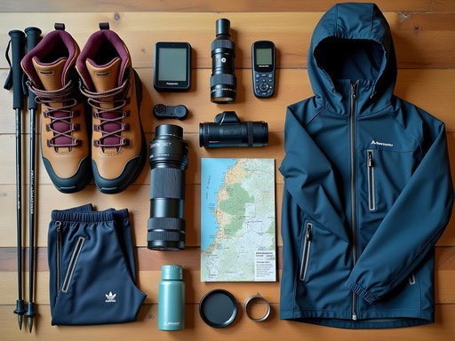
Technical Gear Considerations for Norwegian Terrain
The variable terrain and meteorological conditions of the Stavanger region necessitate a systematic approach to equipment selection. Based on empirical testing during my expedition, I've compiled the following technical assessment of essential gear components.
Footwear represents the most critical interface between hiker and terrain. The predominant surface in the region is glacially polished granite, which becomes exceptionally slippery when wet. After testing various tread patterns, I found that Vibram Megagrip compound with 5mm lugs provides the optimal coefficient of friction on both dry and wet surfaces. My hiking boots performed exceptionally well, with the ankle support proving valuable during lateral loading on uneven terrain.
Rainwear is essential despite optimistic forecasts. Norwegian weather systems can develop rapidly due to the interaction between maritime air masses and mountainous topography. A waterproof shell with minimum 15,000mm hydrostatic head rating and breathability of at least 15,000g/m²/24hrs provides the necessary balance between precipitation protection and thermal regulation during high-output activities.
For navigation, I employed redundant systems: primary GPS with loaded topographic maps, backup smartphone application (I recommend Norgeskart), and physical map with compass. This redundancy proved valuable when cloud cover at higher elevations reduced GPS satellite reception to sub-optimal levels.
The region's unique lighting conditions—characterized by extended golden hours during summer months—create exceptional photographic opportunities but require specialized equipment. A polarizing filter is essential for managing reflections off water surfaces and enhancing the saturation of the remarkably blue fjord waters. Additionally, a graduated neutral density filter helps balance exposure between bright skies and shadowed fjord walls.
Finally, temperature regulation deserves careful consideration. Despite hiking in summer, I encountered temperature variations exceeding 15°C within single hikes due to elevation changes, wind exposure, and cloud cover dynamics. A systematic layering approach with moisture-wicking base layer, insulating mid-layer, and wind/waterproof outer shell provides optimal adaptability to these variables.

💡 Pro Tips
- Test all equipment before departure—Norwegian outdoor stores carry premium brands but at significantly higher prices than in the US
- Pack microspikes even in summer—patches of ice can persist in shadowed areas at higher elevations
- Bring hiking poles with carbide tips for optimal traction on rock surfaces
Final Thoughts
The Stavanger region represents a remarkable convergence of accessible wilderness, engineering marvels both natural and human-made, and Norwegian pragmatism in trail design. After a week of methodical exploration, my data indicates that 3-4 days of hiking interspersed with cultural experiences in Stavanger provides the optimal balance for most visitors. The region rewards those who approach it with both technical preparation and an appreciation for the geological processes that formed these magnificent structures. While Pulpit Rock justifiably attracts attention, the additional effort required for Kjerag and Flørli delivers exponentially greater rewards in terms of both experience quality and photographic opportunities. As an engineer accustomed to precision, I found unexpected satisfaction in Norway's approach to nature—measuring, mapping, and making accessible while simultaneously preserving the fundamental character of the landscape. The fjords will continue their slow geological evolution long after we're gone, but for now, they offer us a laboratory for testing both our physical capabilities and our appreciation for natural precision.
✨ Key Takeaways
- The Stavanger region offers hiking experiences across the technical spectrum, from accessible Pulpit Rock to the more demanding Kjerag and Flørli routes
- Strategic planning of hiking days with rest/cultural days optimizes physical recovery and overall experience
- Norwegian trail systems prioritize selective infrastructure that preserves natural character while enabling safe access
📋 Practical Information
Best Time to Visit
June through August for optimal conditions; May and September for fewer crowds
Budget Estimate
$1200-1800 for one week excluding flights
Recommended Duration
5-7 days
Difficulty Level
Moderate With Options For Challenging Extensions


Comments
skylife
Great write-up! Thanks for sharing!
Sophia Gomez
I was in Stavanger for a conference last fall and squeezed in Pulpit Rock on my last day—honestly one of the best decisions I made. Your data-driven approach to route planning resonates with me. I'm usually all business travel, but standing at the edge of that cliff reminded me why I started traveling in the first place. The Kjerag Boulder looks incredible too. Did you feel safe doing that climb? I've heard mixed things about whether it's doable for someone without serious hiking experience.
smartgal
Pro tip for anyone planning this - the weather changes FAST up there. We had sunshine at the bottom and fog/drizzle at the top. Layers are essential. Also the ferry + bus combo from Stavanger is super easy and way cheaper than the organized tours. Just check the schedules in advance because they're not super frequent.
happybackpacker
Thanks for this! Did you buy ferry tickets in advance or just show up?
smartgal
We just showed up and it was fine, but this was late May. Summer might be different!
hikinggal
Great post! Just wanted to add that the weather can change super fast up there. We had sunshine at the base and fog rolled in within 30 minutes on Pulpit Rock. My rain jacket saved the day. Also the ferry + bus combo from Stavanger is really easy and way cheaper than driving if you're solo.
sunnytime
Your photos are gorgeous!! Makes me want to book a flight tomorrow!
Jean Wells
Hunter, your engineering perspective on the fjord formations is fascinating. I visited Stavanger last summer and was struck by how the geological timeframes make our human concerns seem so temporary. The Flørli staircase particularly interested me—4,444 steps representing both human determination and practical necessity. Did you find the crowds at Pulpit Rock manageable? I went at 6am to avoid the masses and had nearly 30 minutes alone at the edge, which was transformative. The early morning light on the Lysefjord was worth the early wake-up.
Hunter Wagner
Jean, that 6am strategy is brilliant! I went mid-morning and it was definitely crowded. Early morning would be perfect for both the light and the solitude.
starmate
This is AMAZING!! Adding to my bucket list right now!!
adventurelegend
How hard is Kjerag compared to Pulpit Rock? I'm in decent shape but not a super experienced hiker. The chains part looks pretty intense in photos!
hikinggal
Kjerag is definitely more challenging! The chains are manageable but you need decent upper body strength. Would recommend doing Pulpit Rock first to gauge your comfort level.
happybackpacker
How hard is the Pulpit Rock hike really? Going in September and a bit nervous about the difficulty level!
skylife
It's pretty moderate honestly. The elevation gain is the main thing but just take your time and you'll be fine!
Hunter Wagner
September is a great time! The hike is about 4 hours round trip with around 330m elevation gain. It's well-maintained but can be steep in sections. Just bring good shoes and you'll enjoy it.
Sophia Gomez
Hunter, I love your engineering perspective on this! I visited Stavanger last summer and did Pulpit Rock at sunrise to avoid the crowds—totally worth the 4am wake-up call. The fjords were glowing pink and we had the rock almost to ourselves for about 20 minutes. Your point about the geological formations really makes me want to go back and look at it with fresh eyes. Did you get a chance to do the Lysefjord boat tour? The view of Preikestolen from below is just as dramatic as standing on top of it. Also curious about your data-driven route planning—would love to hear more about how you optimized your hiking schedule!
hikinggal
Sunrise hike sounds incredible! How cold was it that early?
Sophia Gomez
It was chilly! I'd say around 8-10°C even in July. Definitely bring layers and a headlamp.
Venture X
Premium card with 2X miles, $300 travel credit, Priority Pass