

Disclosure: This article contains affiliate links. We may earn a commission from purchases at no extra cost to you, which helps our travel content.
The first time I gazed upon a Norwegian fjord, I was reminded of those quiet moments during night shifts in Calgary, where the vastness of the night sky would momentarily make me forget the chaos of urban policing. Norway's landscapes have that same humbling effect. After visiting Olympic venues in Lillehammer, I found myself drawn to Alesund, a picturesque art nouveau town serving as the perfect gateway to some of Norway's most spectacular hiking terrain. The region combines everything I love about travel: breathtaking natural phenomena, rich cultural history, and the kind of clear night skies that make a former rookie cop turned amateur astronomer weak in the knees. Over seven summer days, my hiking boots covered terrain that ranged from moderate coastal paths to challenging mountain ascents, each rewarding me with views that no photograph could truly capture. If you and your partner are seeking an active adventure with unforgettable scenery, these seven hikes near Alesund deliver Nordic magic in spades.

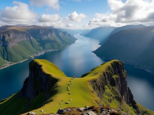
Sukkertoppen: The Perfect Introduction to Alesund's Landscapes
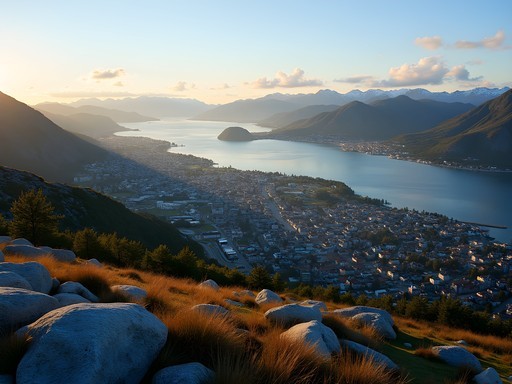
If you're fresh off the plane and eager to stretch your legs without committing to a full-day excursion, Sukkertoppen (Sugar Top) is your answer. This 314-meter hill sits like a sentinel overlooking Alesund, offering the perfect orientation to the region's geography.
The trail begins just 20 minutes from downtown, making it accessible even with jet lag clouding your judgment (something I know all too well from my Olympic security days when shift changes wreaked havoc on my sleep schedule). The path winds through residential neighborhoods before transitioning to a well-marked but increasingly steep rocky trail.
About halfway up, I encountered a Norwegian couple in their 70s who passed me with casual ease, a humbling reminder that my police fitness training back home might need some adjustments. The final push requires some light scrambling over rocks, but nothing that demands technical skills.
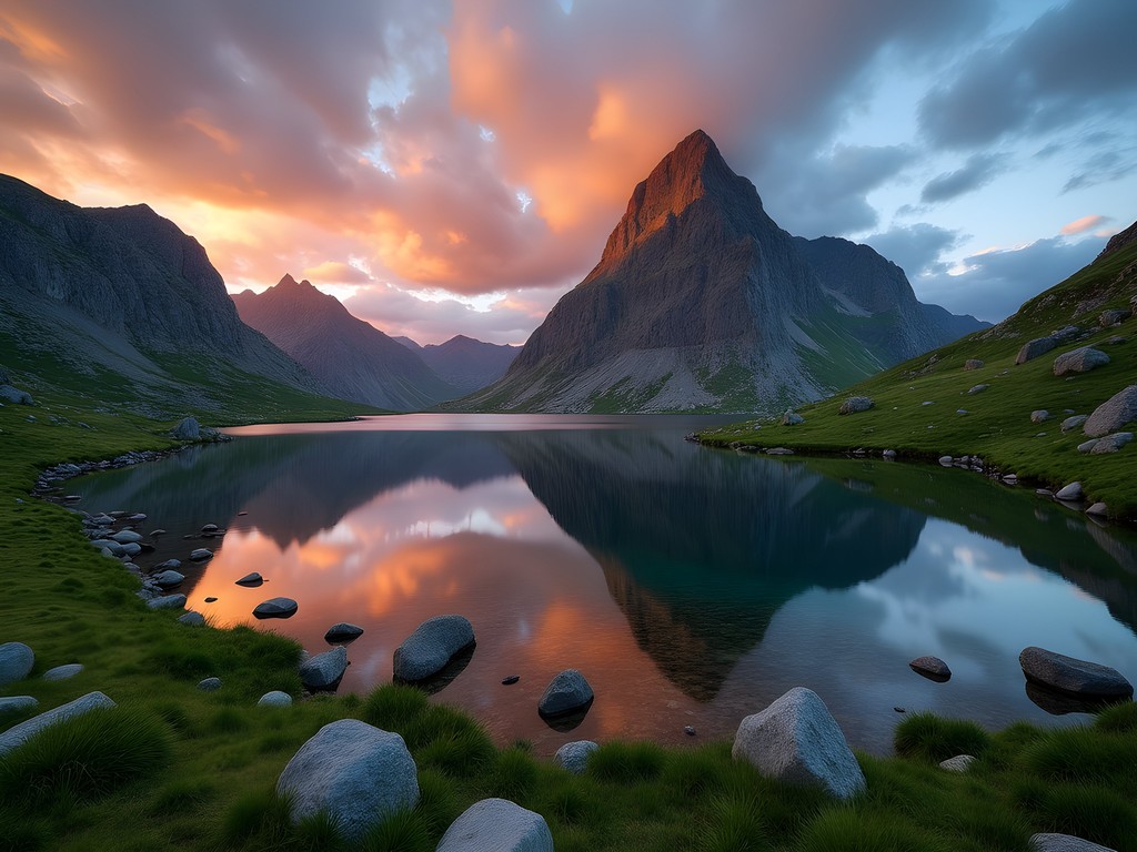
The panorama from the summit is what Norwegians might call 'praktfull' (magnificent) – Alesund's distinctive art nouveau architecture spreads below like a colorful Lego set, while the surrounding islands create a mosaic in the sea. On clear days, the distant peaks of the Sunnmøre Alps create a jagged horizon that had me reaching for my compact binoculars, which proved invaluable throughout my Norwegian adventures.
I timed my hike for sunset, bringing along a thermos of coffee and my stargazing journal. As twilight descended, the city lights began twinkling below, creating an interesting counterpoint to the emerging stars above – though Norway's summer brings such extended daylight that serious astronomy had to wait for another season.

💡 Pro Tips
- Start late afternoon for the best lighting conditions for photography
- Pack a windbreaker – the summit can be significantly cooler and windier than the town below
- Bring headlamps if descending after sunset as parts of the trail can be tricky in low light
Alnes Lighthouse Trail: Coastal Charm on Godøy Island
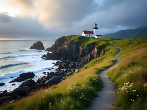
Sometimes the best hikes aren't about conquering imposing peaks but experiencing the raw power of nature at sea level. The coastal trail around Alnes Lighthouse on Godøy Island offers precisely this kind of intimate connection with Norway's maritime heritage.
Reaching the trailhead requires a scenic 30-minute drive from Alesund through the undersea tunnel to Godøy Island. As a police officer accustomed to maintaining situational awareness, I couldn't help but marvel at the engineering feat of these tunnels – a reminder of Norway's commitment to connecting its communities despite formidable geographical barriers.
The lighthouse itself dates back to 1876 and stands as a stoic sentinel against the often-turbulent Norwegian Sea. Before hitting the trail, I recommend climbing the lighthouse tower for orientation (and some historical context from the small museum inside).
The hiking path follows the rugged coastline, with waves crashing dramatically against weather-worn rocks below. Unlike many of Norway's more famous hikes, this route rarely sees crowds, allowing for moments of peaceful contemplation. During my visit, I encountered only a local fisherman who pointed out a colony of seals lounging on distant rocks – a sight I might have missed without my zoom lens, which proved invaluable for wildlife spotting throughout my Norwegian adventures.
The terrain alternates between grassy paths and rocky sections, requiring sturdy footwear but minimal technical skill. What makes this hike special is the ever-changing interplay between land and sea, punctuated by small sandy beaches that appear like golden surprises amid the rocky shoreline.
After completing the roughly 5km loop, I treated myself to fresh waffles at the lighthouse café, where the owner shared stories of winter storms so powerful they sent spray over the top of the lighthouse – a humbling reminder of nature's force in this seemingly peaceful summer setting.

💡 Pro Tips
- Check lighthouse opening hours in advance if you want to climb the tower
- Bring a windproof layer – coastal breezes can be deceptively chilly even on sunny days
- Time your visit with low tide to explore tidal pools teeming with marine life
Geiranger Skageflå Farm Hike: A Journey Through UNESCO Heritage
Some hikes tell stories that span centuries, and the trail to abandoned Skageflå Farm does exactly that while offering some of the most iconic views of Geirangerfjord, a UNESCO World Heritage site. This was the hike that made me understand why Norwegians have such a profound connection to their landscape – it's not just beautiful; it's embedded in their cultural identity.
Getting to the trailhead requires a two-hour drive from Alesund to Geiranger village, followed by a ferry ride into the fjord. This approach alone is worth the journey, as the ferry provides spectacular views of the Seven Sisters and Bridal Veil waterfalls cascading down near-vertical cliff faces.
The hike begins at Skagehola, where you disembark from the ferry. The trail immediately asserts its challenging nature with a steep ascent through dense forest. My years of police fitness training proved useful here, but I still found myself stopping frequently – ostensibly to photograph wildflowers, but really to catch my breath.
After about an hour of steady climbing, the forest gives way to increasingly dramatic views of the fjord below. The trail hugs the mountainside, occasionally protected by cables in exposed sections. It's during these moments, with the fjord waters glistening 270 meters below, that I felt most alive – that perfect balance of exhilaration and focus that comes with moderate risk.
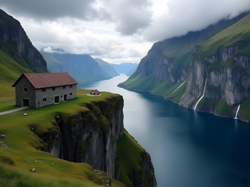
Skageflå Farm itself is a powerful testament to human determination. Perched on a mountain ledge, this farm was inhabited until 1916, with generations of Norwegians carving out an existence in what seems like an impossible location. Sitting among the preserved stone structures, I pulled out my insulated water bottle (which had kept my coffee miraculously hot despite hours on the trail) and tried to imagine daily life in such an isolated yet breathtaking setting.
The return journey offers two options: retrace your steps to catch the ferry back or continue climbing to the summit and descend to Geiranger by the Hole-Homlongsætra trail. I chose the latter for variety, though my quads protested the additional 400 meters of elevation gain before the welcome descent.
💡 Pro Tips
- Book ferry tickets in advance during peak season (June-August)
- Start early to avoid afternoon crowds and ensure you don't miss the last return ferry
- Pack more water than you think you'll need – the exposed sections can be surprisingly hot in summer

Trollstigen to Bispevatnet Lake: Engineering Marvel Meets Natural Wonder
Some hiking experiences begin before you even lace up your boots. The drive to Trollstigen (Troll's Ladder) is itself an adventure – a masterpiece of engineering featuring 11 hairpin turns ascending a steep mountainside. As someone who's navigated plenty of challenging roads during police pursuits back home, I still found myself white-knuckling the steering wheel at certain points.
The Trollstigen visitor center, perched dramatically at the top of the pass, serves as the trailhead for this hike. Before setting out, take time to appreciate the architectural marvel of the viewing platforms that jut out over the valley, offering vertigo-inducing perspectives of the road you've just conquered.
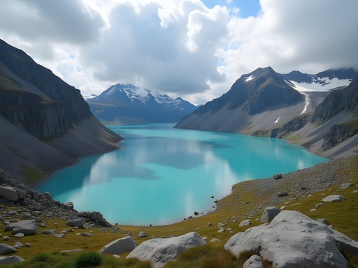
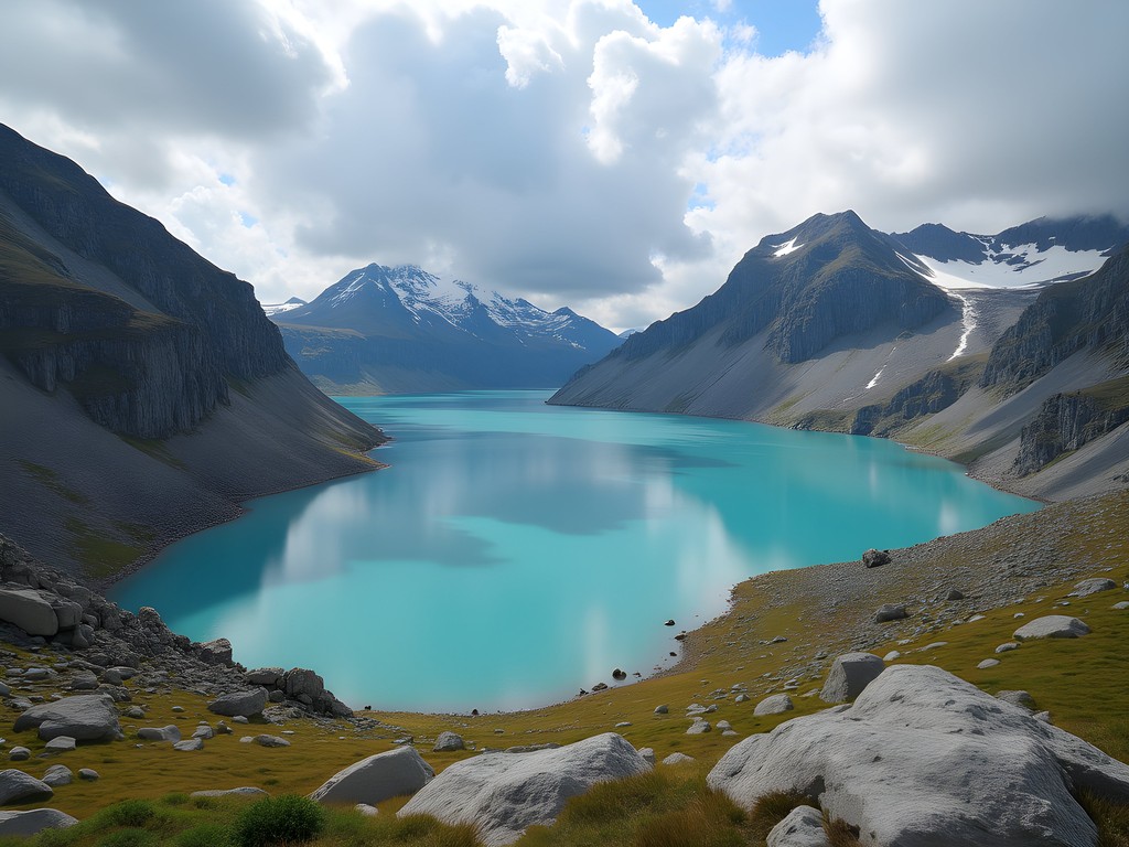
The trail to Bispevatnet Lake begins behind the visitor center, quickly leaving the crowds behind as it ascends through rocky terrain marked by cairns (stone stacks marking the path). This is quintessential Norwegian high mountain landscape – stark, dramatic, and utterly captivating.
As the path climbs, the vegetation becomes increasingly sparse, creating an almost lunar landscape punctuated by small patches of resilient alpine flowers. About 45 minutes into the hike, you'll reach a ridge offering the first glimpse of Bispevatnet Lake, its waters often appearing an otherworldly blue due to glacial minerals.
The final approach to the lake involves some light scrambling over rocks, but the reward is a tranquil alpine setting that feels worlds away from the tourist bustle at Trollstigen. I spent nearly an hour at the lakeshore, using my packable camping chair (one of my best travel investments for moments precisely like this) while watching clouds cast moving shadows across the surrounding peaks.
If weather permits and you're feeling energetic, you can extend this hike by continuing to Bisperonden peak for even more expansive views. I opted for this extension and was rewarded with a perspective that included multiple valleys, distant fjords, and even a glimpse of the Atlantic on the clearest of days.
The descent offers constantly changing angles on the dramatic landscape, with late afternoon light creating shadow play that transforms the scenery hour by hour. By the time I returned to the visitor center, the day tourists had largely departed, allowing for a peaceful sunset viewing from the platforms.
💡 Pro Tips
- Start this hike early or late in the day to avoid the midday tourist crowds at Trollstigen
- Weather changes rapidly at this elevation – pack layers and rain protection regardless of the forecast
- Bring extra camera batteries – the photographic opportunities are endless and drain power quickly
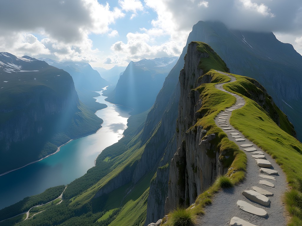
Romsdalseggen Ridge: The Ultimate Panoramic Challenge
When Norwegians themselves rank a hike among their country's most beautiful, you know it's special. Romsdalseggen Ridge lives up to this reputation, offering what might be the most dramatic mountain panorama in a country famous for dramatic mountain panoramas. This is not a hike for beginners or the faint-hearted – it demands respect, preparation, and a reasonable level of fitness.
The logistics require some planning: most hikers take the early morning shuttle bus from Åndalsnes to the Vengedalen starting point, then hike one-way back to town. This arrangement allows you to tackle the ridge from its most approachable angle while ending with a spectacular descent into the Romsdalen Valley.
The initial ascent from Vengedalen is steep but straightforward, with a well-maintained path through forest that eventually gives way to open mountainside. As you gain elevation, the views begin to unfold – first of the immediate valleys, then, as you approach the ridge itself, the full panorama of the Romsdalen mountains.
The ridge section presents three route options of varying difficulty. Having assessed conditions and my comfort level (my police training has instilled a perhaps excessive risk assessment habit), I chose the middle route, which offers plenty of exposure and drama without requiring technical climbing skills.
The ridge walk is approximately 10km of continuous jaw-dropping scenery. To one side, the Romsdalen Valley plunges nearly 1,500 meters down to the valley floor where the Rauma River winds like a silver thread. To the other side, countless peaks stretch toward the horizon, including the imposing Trollveggen (Troll Wall) – Europe's tallest vertical rock face.
About halfway along the ridge, I encountered a perfect lunch spot sheltered from the wind. Here I deployed my lightweight stove to prepare what might have been the most scenic cup of mountain coffee in my life. The simple pleasure of warm beverage with such an extraordinary backdrop is something I've cherished since my stargazing nights back in Calgary.
The final descent into Åndalsnes is lengthy but rewards with constantly changing perspectives of the town and fjord below. By the time I reached the valley floor, my legs were trembling with fatigue, but the sense of accomplishment far outweighed the physical discomfort.
💡 Pro Tips
- Book the shuttle bus to Vengedalen at least a day in advance during peak season
- Check weather forecasts carefully – this is not a ridge to attempt in high winds or poor visibility
- Allow 7-9 hours for the complete hike, depending on your pace and how often you stop for photos
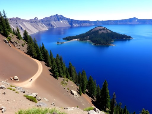
Hjørundfjord and Saksa Peak: The Local's Secret Fjord
While Geirangerfjord gets most of the international attention, many Norwegians consider Hjørundfjord to be even more beautiful – and significantly less crowded. This hidden gem, surrounded by the Sunnmøre Alps, offers what might be the perfect balance of accessibility and wilderness.
The most rewarding hike in the area is the ascent of Saksa peak, a distinctive mountain whose name means 'scissors' in Norwegian – a reference to its uniquely shaped double summit that resembles an open pair of scissors.
The journey begins with a ferry ride from Ålesund to the small village of Urke, a trip that offers a perfect introduction to Hjørundfjord's dramatic landscapes. In Urke, population approximately 40, I felt transported back in time – the kind of place where everyone knows everyone, and a stranger like me receives curious but friendly glances.
The trail starts gently enough, winding through farmland before beginning its serious ascent through forest. As a solo female hiker, I always maintain awareness of my surroundings (occupational habit from police work), but Norway's trails consistently feel safe and well-marked.
As the tree line recedes, the path becomes steeper and rockier, requiring occasional use of hands for balance. The compensation for this effort comes in the form of increasingly spectacular views of Hjørundfjord stretching below, its dark waters contrasting with the surrounding green mountainsides.
The final approach to Saksa's 1,073-meter summit involves some mild exposure but nothing technically challenging. Standing atop this peak offers what many consider the definitive Hjørundfjord panorama – a 360-degree spectacle of mountains plunging dramatically into fjord waters.
During my visit, I shared the summit with only two other hikers – a stark contrast to the tourist-heavy experiences at more famous Norwegian destinations. We exchanged knowing smiles, the universal language of those who've discovered something special off the beaten path.
The descent follows the same route, though with entirely different perspectives as you face the fjord throughout. Back in Urke, I highly recommend stopping at the historic Hotel Union Øye for their traditional Norwegian waffles – the perfect recovery meal with a side of cultural history. This hotel has hosted European royalty for generations and maintains an atmosphere of elegant nostalgia that perfectly complements the timeless landscape outside.

💡 Pro Tips
- Check ferry schedules carefully as services to Urke are limited, especially in shoulder seasons
- Start early to ensure you can complete the hike and catch an afternoon ferry back to Ålesund
- The summit can be windy even on calm days – pack an extra layer for comfort
Molladalen and Slogen: Norway's Most Beautiful Mountain Valley
When a mountain valley is described in Norwegian hiking literature as 'eventyrdalen' (the fairy tale valley), expectations run high. Molladalen doesn't just meet these expectations – it exceeds them, offering what might be the perfect synthesis of challenging hiking and reward-to-effort ratio.
The approach to Molladalen requires a drive to Øye, followed by a steadily ascending forest trail that initially gives little hint of the grandeur to come. The first two hours of hiking might seem pleasant but unremarkable – a green tunnel through pine and birch with occasional glimpses of the valley below.
It's when you finally break through the tree line that Molladalen reveals itself in a moment that literally stopped me in my tracks. The valley opens up like a perfect mountain amphitheater, surrounded by jagged peaks reflected in a series of small alpine lakes. The centerpiece of this natural cathedral is Slogen mountain (1,564m), its distinctive pyramid shape drawing the eye like a siren call.
Though reaching Slogen's summit adds considerable challenge to the day, it's well worth the effort if weather and fitness permit. The final approach requires some scrambling and comfort with exposure, but the 360-degree panorama from the top encompasses countless peaks, several fjords, and on clear days, a glimpse of the open Atlantic.
During my ascent, I encountered a Norwegian family spanning three generations – including an 11-year-old girl and her 72-year-old grandfather – all making their way confidently up terrain that would be considered challenging in most countries. It was a powerful reminder of Norway's deeply ingrained outdoor culture and the intergenerational transmission of mountain skills.
For those not inclined to tackle Slogen, simply exploring Molladalen offers a full day of wonder. The valley floor features a network of trails connecting several crystal-clear lakes, each offering perfect reflections of the surrounding peaks when wind conditions cooperate.
I spent my evening watching sunset transform the mountain walls from gray to gold while testing out my new ultralight tent, which proved ideal for the variable conditions Norwegian mountains can present. As darkness finally fell around midnight (summer nights in Norway are magically extended), I enjoyed some of the best stargazing of my trip, with the surrounding peaks creating a perfect natural observatory.
💡 Pro Tips
- This is a full-day commitment – start early and bring headlamps in case your return extends into evening
- The trail can be boggy in sections after rain – waterproof hiking boots are essential
- Consider camping in Molladalen to fully experience the changing light on the mountain walls
Final Thoughts
As I packed my hiking boots for the return journey to Cleveland, I couldn't help but reflect on how Norway's landscapes had affected me. Like the night sky that first captured my imagination during those quiet police shifts in Calgary, the fjords and mountains around Alesund possess a magnitude that puts human concerns into perspective. Each of these seven hikes offers something unique – from the accessible panorama of Sukkertoppen to the fairy tale valley of Molladalen – yet all share that quintessential Norwegian blend of dramatic beauty and thoughtful trail design. Whether you and your partner are experienced hikers or simply outdoor enthusiasts seeking memorable views, Alesund's surrounding terrain delivers experiences that will linger in your memory long after your plane touches down at home. Just remember to look up from the trail occasionally – not just at the mountains, but at the person sharing these moments with you. In landscapes this magnificent, connections deepen and everyday worries fade away. Isn't that what travel is truly about?
✨ Key Takeaways
- The Alesund region offers hikes for various skill levels, from the moderate Sukkertoppen to the challenging Romsdalseggen Ridge
- Less-visited areas like Hjørundfjord provide equally stunning landscapes with fewer crowds than famous spots like Geirangerfjord
- Summer offers extended daylight hours perfect for hiking, but also means popular trails can get crowded – start early or late for the best experience
- Public transportation can access many trailheads, but having a rental car provides maximum flexibility for exploring the region's diverse hiking options
📋 Practical Information
Best Time to Visit
June through August for optimal hiking conditions; late May and early September for fewer crowds
Budget Estimate
$150-200 per day per couple including accommodations, transportation, and meals
Recommended Duration
7-10 days to experience several hikes without rushing
Difficulty Level
Moderate To Challenging, With Options For Various Fitness Levels
Comments
AdventureCouple
These views are unreal! Thanks for sharing!
winternomad
Going there in August!! So excited. Did you rent a car or is public transport doable for most of these trails?
sunsetlife
I'd love to know this too! Planning my first Norway trip
beachguy
Really like your photos! The one from Trollstigen is incredible
SoloHiker88
Just got back from Alesund last week! Quick tip: the weather apps aren't always accurate there. I'd recommend checking with locals each morning before heading out. Saved me from getting caught in a storm on Sukkertoppen!
Bryce Diaz
Ana, this brought back so many memories! I did Sukkertoppen back in 2022 during a solo trip through Norway, and you're absolutely right about it being the perfect introduction. The 360-degree views at the top are unreal. One tip I'd add for anyone planning this - start early morning if you can. I went up around 6am and had the entire summit to myself for a solid hour. The light hitting the fjords at sunrise is something I'll never forget. Also packed my hiking poles which really helped on the steeper sections coming back down. The Alnes Lighthouse trail is next on my list!
beachguy
6am?? Wow you're dedicated lol. But yeah those sunrise pics are always worth it
journeyperson
Great post Ana! Quick question - what time of year did you do these hikes? I'm trying to figure out if late June would work or if it's too crowded. Also curious about the difficulty level on the Geiranger Skageflå Farm hike - is it doable for someone with moderate fitness?
winternomad
Not Ana but I went in early July last year and it was busy but manageable! Definitely worth it for the weather.
journeyperson
Thanks! That's helpful to know
sunsetlife
Wow this looks absolutely amazing!! Adding to my bucket list right now 😍
escapediver
Your photos are gorgeous! Really inspired me to finally book Norway
Gregory Boyd
Excellent write-up, Ana. I did the Trollstigen to Bispevatnet hike last summer and completely agree about the engineering marvel aspect. What struck me most was how the trail transitions from the dramatic roadside viewpoints to the serene alpine lake environment. One tip for readers: start early morning (before 8am) to avoid the tour bus crowds at Trollstigen itself. The trail gets much quieter once you're 20 minutes in. The weather can shift rapidly up there, so layering is essential even in summer. Did you make it to Stigrøra waterfall on your way down?
escapediver
Good to know about the crowds! Definitely doing the early start
sunnyexplorer
Going in July!! How hard is the Geiranger hike? I'm not super experienced but in decent shape
Gregory Boyd
It's moderate - the elevation gain is steady but manageable if you take your time. Just pace yourself and bring plenty of water!
sunnyexplorer
Thanks!! Super helpful
Venture X
Premium card with 2X miles, $300 travel credit, Priority Pass