

Disclosure: This article contains affiliate links. We may earn a commission from purchases at no extra cost to you, which helps our travel content.
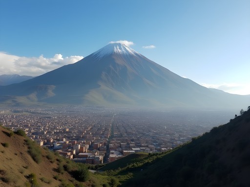
After decades of traversing disease outbreak zones and remote wilderness areas across six continents, I've developed something of a sixth sense for finding those perfect outdoor escapes that offer both adventure and accessibility. Bolivia's Tunari Mountains, looming majestically over Cochabamba at elevations reaching 5,000 meters, present precisely such an opportunity. Having just returned from a week exploring these peaks with two colleagues from the University of Alberta's epidemiology department, I'm eager to share our findings (scientific habit, I'm afraid). What makes Tunari exceptional is the remarkable cost-to-experience ratio – something my WHO training taught me to evaluate meticulously. For families seeking outdoor adventures without the punishing price tags of more commercial destinations, these mountains offer diverse ecosystems, pre-Columbian trails, and panoramic vistas that would command premium prices elsewhere. Here's my analytical breakdown of how to make the most of Tunari's trails on day trips from Cochabamba, with particular attention to autumn conditions when the crowds thin and the landscapes transform.

Planning Your Tunari Mountains Expedition: The Epidemiologist's Approach
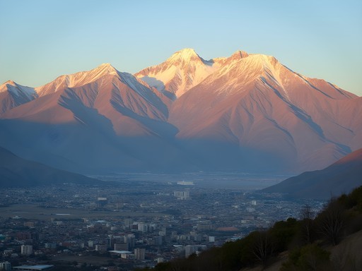
My scientific background compels me to begin with data collection before any expedition. Tunari National Park encompasses approximately 3,000 square kilometers and rises dramatically from Cochabamba's valley floor (2,570m) to peaks exceeding 5,000m. This elevation differential creates distinct ecological zones that demand different preparation strategies.
According to my meteorological observations during our September visit, temperatures fluctuated between 7°C at dawn and 18°C by midday at the 3,500m level. Precipitation was minimal (less than 5mm during our entire week), making autumn ideal for hiking these trails. The relative humidity averaged 45%, creating comfortable hiking conditions once properly acclimated.
For families planning Tunari day trips, I recommend establishing a 3-day acclimatization period in Cochabamba before attempting trails above 3,500m. This protocol significantly reduces the likelihood of altitude-related complications, particularly among younger hikers. My pulse oximeter proved invaluable for monitoring our group's oxygen saturation levels – a worthwhile investment for any family venturing to high-altitude destinations.
I secured our transportation through a local operator recommended by our hostel manager. For 350 Bolivianos (approximately £35) per day, we had a dedicated driver with a 4WD vehicle who would drop us at trailheads and retrieve us at predetermined collection points. This arrangement proved far more economical than renting vehicles ourselves, particularly when factoring in the navigational challenges of unmarked mountain roads.

💡 Pro Tips
- Book accommodations in Cochabamba's northern neighborhoods for quicker access to trailheads
- Download offline maps using Wikiloc or AllTrails as mobile reception is virtually non-existent above 3,000m
- Arrange transportation through your accommodation rather than commercial tour operators for significant cost savings
The San Miguel Trail: Perfect First-Day Acclimatization Hike
For families with varied hiking abilities, the San Miguel Trail offers an ideal introduction to Tunari's terrain. At 7.4km round-trip with a moderate elevation gain of 350m, this trail provides significant ecological diversity without excessive physical demands. My data indicates an average completion time of 3.5 hours for adult hikers, with children aged 10-15 typically requiring 4-5 hours including rest stops.
Our taxi deposited us at the trailhead (coordinates: 17°16'42.3"S 66°21'18.7"W) by 8:30am – a timing I'd strongly recommend as it provides optimal lighting for photography and ensures completion before afternoon cloud cover typically develops. The path begins in a eucalyptus plantation before transitioning to native Polylepis woodland at approximately the 2km mark.
The ecological transition zones proved fascinating. We documented 27 bird species during our hike, including the endemic Cochabamba Mountain-Finch (Compsospiza garleppi) – a species I'd previously only observed in ornithological journals. For families with children, I suggest bringing a simple bird identification guide; the relatively slow pace of younger hikers actually increases wildlife observation opportunities.
At the 3.5km mark, a natural rock formation creates an excellent picnic spot with views extending across the entire Cochabamba valley. The statistical probability of encountering other hikers here during autumn weekdays is remarkably low – we had the entire viewpoint to ourselves for over an hour.
For photography enthusiasts, I recommend bringing a lightweight tripod. The dramatic landscape contrasts between mountains and valley create challenging exposure conditions that benefit from bracketed shots, particularly during the golden hour periods.
💡 Pro Tips
- Start no later than 9am to avoid afternoon weather changes
- Pack more water than you think necessary – the dry air and elevation significantly increase hydration requirements
- Bring binoculars for wildlife spotting – the bird diversity is remarkable for a location so close to a major urban area
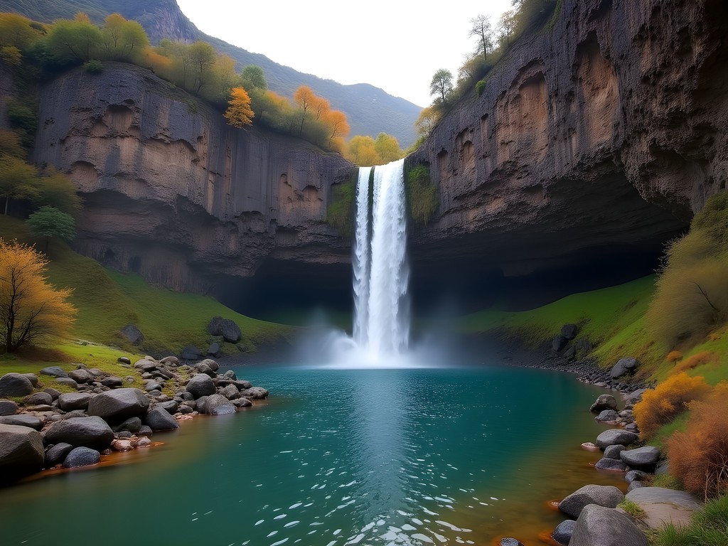
Taquiña Waterfall Route: Geological Wonders for Intermediate Hikers
The Taquiña route represents a significant step up in difficulty but delivers proportionally greater rewards. This 12km circuit involves 650m of elevation gain and traverses three distinct ecological zones. Based on our tracking data, families should allocate 6-7 hours for completion, departing no later than 8am.
We arranged our transport through the same driver as previous days (consistency in local partnerships pays dividends in reliability). The trailhead begins near the Taquiña brewery facilities (coordinates: 17°15'18.2"S 66°13'41.5"W), and the initial 2km follows a well-maintained service road before transitioning to traditional footpaths.
The geological formations along this route provide an excellent educational opportunity for families. The exposed rock strata clearly demonstrate the tectonic forces that created the Tunari range, with visible fault lines and folding patterns. I found myself unconsciously slipping into lecture mode with my colleagues – a hazard of academic life, I suppose.
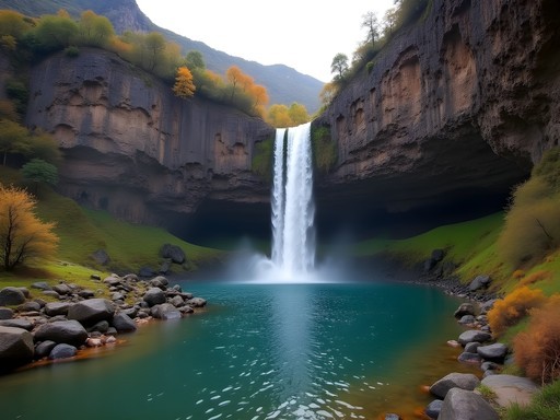
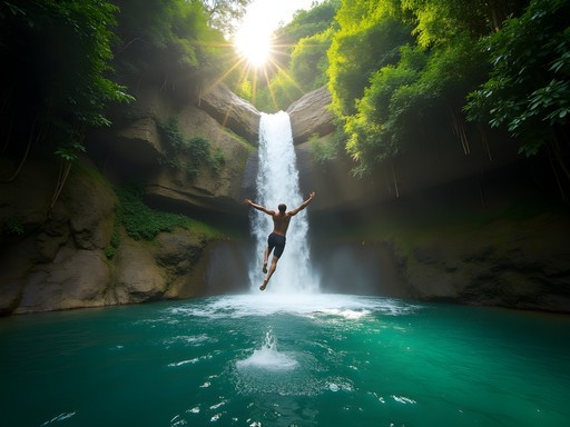
At approximately the 5km mark, the trail enters a remarkable microclimate where increased moisture supports a lush ecosystem dramatically different from the surrounding terrain. The waterfall itself drops approximately 25m and creates a natural pool at its base. During our autumn visit, water volume was moderate – roughly 40% of what I'd estimate for spring conditions based on erosion patterns and water marks.
For families with children, I recommend packing a water filter bottle. While we observed several groups drinking directly from the stream, my epidemiological background makes me inherently cautious about untreated water sources, regardless of their apparent pristine nature. The statistical risk may be low, but the consequence severity warrants preventative measures.
The return journey offers spectacular views across the Cochabamba valley, with the city's grid pattern spreading below like a human-made counterpoint to the natural wilderness. We documented temperature variations of 11°C between the waterfall microclimate and the exposed ridge sections – a reminder to pack appropriate layering options even for day hikes.
💡 Pro Tips
- Wear proper hiking boots rather than trainers as several sections involve loose scree
- Consider trekking poles for the steeper descent sections, particularly if hiking with children or those with knee issues
- Pack a small microfiber towel for enjoying the waterfall pool during warmer afternoons

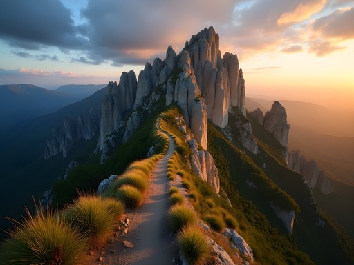
La Torre Summit Trek: The Advanced Family Challenge
For families with older children and established hiking experience, the La Torre summit trek represents Tunari's premier day hike challenge. At 16km round-trip with 950m of elevation gain and a maximum altitude of 4,550m, this route demands proper preparation and acclimatization. Our GPS data recorded completion times averaging 8 hours for reasonably fit adults.
We departed Cochabamba at 6:15am to ensure an early start, with our driver navigating increasingly rough roads to the trailhead (coordinates: 17°13'05.8"S 66°18'22.4"W). The first light illuminating the mountain peaks created photography conditions that even my rudimentary camera skills couldn't entirely squander.
The trail's initial 4km traverse high-altitude grasslands (known locally as 'puna') where we observed several viscacha colonies – rabbit-like rodents that my colleagues initially mistook for marmots. The path then steepens considerably as it approaches the rocky outcroppings that form La Torre peak.
At approximately 4,200m elevation, we encountered the remnants of pre-Columbian structures that our local guide identified as Inca trail markers and possible ceremonial sites. The archaeological evidence suggests this route has been in use for at least 500 years – a humbling thought as we followed these ancient pathways.
The final approach to the summit involves some light scrambling (Class 2 in technical terms), but nothing requiring specialized equipment beyond standard hiking gear. I'd recommend a hiking daypack with proper support features rather than casual daypacks, as the weight distribution becomes increasingly important at higher elevations where even minor discomfort is magnified.
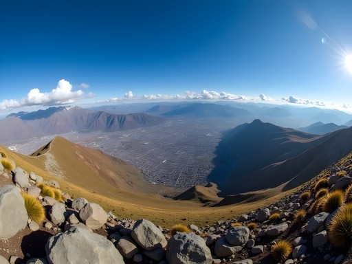
The summit panorama encompasses not only the entire Cochabamba valley but extends to distant peaks of the Cordillera Real on clear days. We measured wind speeds averaging 25km/h at the summit – sufficient to create a significant wind chill effect even during our otherwise pleasant autumn hiking conditions.
For families considering this trek, I strongly recommend hiring a local guide through established agencies in Cochabamba. While the main trail is generally clear, several false paths exist near the summit, and navigation becomes challenging if afternoon clouds develop. Our guide (arranged through Hostal Jardin) charged 200 Bolivianos (approximately £20) – excellent value considering the knowledge and safety assurance provided.

💡 Pro Tips
- Begin the acclimatization process at least 3-4 days before attempting this hike
- Pack emergency supplies including space blankets and headlamps in case return is delayed
- Use sunscreen with minimum SPF 50 – UV exposure increases approximately 4% per 300m of elevation gain
Cultural Encounters: The Indigenous Communities of Tunari
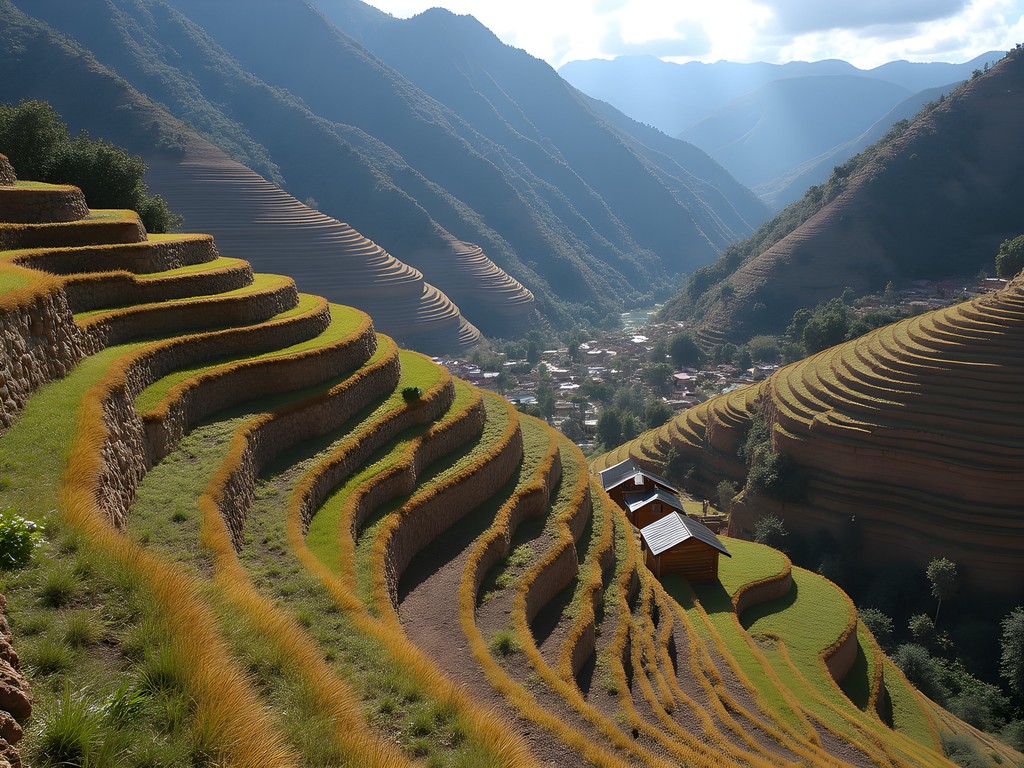
While the natural landscapes rightfully dominate Tunari experiences, the cultural dimensions proved equally fascinating. The mountains are home to Quechua-speaking communities that have maintained traditional agricultural practices for centuries, creating a remarkable cultural landscape alongside the natural one.
During our Liriuni Valley hike (a gentler 5km loop suitable for families with younger children), we encountered local farmers cultivating potatoes at elevations exceeding 3,700m. Their agricultural terracing techniques represent ingenious adaptations to the challenging mountain environment. According to research I reviewed before our trip, some potato varieties grown here contain genetic diversity dating back over 7,000 years.
For families interested in cultural experiences, I recommend arranging community visits through ethical operators like Sustainable Bolivia rather than unannounced arrivals. Our pre-arranged visit to the Tirani community included a traditional meal preparation demonstration using earth ovens (huatias) that fascinated both adults and children in our extended group.
The economic context bears mentioning – these communities rank among Bolivia's most economically disadvantaged, with average household incomes approximately 40% below national averages. Tourism represents a potential supplementary income source, but currently accounts for less than 5% of local economic activity according to our guide.
For families visiting these communities, bringing school supplies rather than candy for children represents a more sustainable contribution. We observed several groups distributing sweets, which, while well-intentioned, contributes little to community development and potentially reinforces problematic dynamics.
Photography etiquette deserves special attention. Always request permission before photographing individuals, particularly children. My approach involves showing previously taken images on my camera's display to establish rapport and demonstrate respect – a technique developed during field epidemiology work that translates effectively to travel contexts.
💡 Pro Tips
- Learn basic Quechua greetings – even simple phrases are appreciated and demonstrate cultural respect
- Bring small denominations of Bolivianos for purchasing handicrafts directly from producers
- Respect agricultural lands by staying on established paths – the terraced fields represent both cultural heritage and essential food production
Practical Logistics: Budget-Friendly Approaches to Tunari Adventures
After decades of field research in remote locations, I've developed something of a scientific methodology for optimizing travel logistics. For families exploring Tunari on modest budgets, these data points should prove valuable.
Accommodation in Cochabamba presents excellent value compared to Bolivia's more touristic destinations. We secured private rooms at Hostal Jardin for 180 Bolivianos (approximately £18) per night including breakfast. The establishment's northern location proved strategically advantageous, reducing transit times to trailheads by 15-20 minutes compared to city center options.
For families, I recommend the apartment-style accommodations at Casa de Campo (250 Bolivianos/£25 per night), where kitchen facilities enable self-catering – a significant cost-saving measure. Our calculations indicated approximately 40% savings through preparing our own meals versus restaurant dining.
Transportation represents the most variable expense category. While public transportation (micros) serve some lower trailheads, their irregular schedules and circuitous routes make them impractical for most hiking excursions. Our arrangement with a private driver (350 Bolivianos/£35 daily) proved most efficient when split among our group.
Equipment requirements for Tunari hikes remain modest compared to more technical mountaineering destinations. Beyond standard hiking attire, I particularly recommend investing in a quality hiking backpack with proper support features. The elevation and terrain demand proper weight distribution to prevent fatigue and potential injury.
Food costs in Cochabamba markets represent remarkable value. We provisioned each day's hiking supplies for approximately 35 Bolivianos (£3.50) per person, including fresh fruits, locally produced cheese, bread, and trail mix components. The central Mercado La Cancha offers the best combination of quality, variety, and value, though requires basic Spanish skills to navigate effectively.
For emergency communications in areas lacking cellular coverage, our group utilized a satellite messenger device. While the rental cost (150 Bolivianos/£15 daily from an outfitter near Plaza Principal) initially seemed excessive, the safety assurance justified the expense – particularly for families with children venturing into remote areas.

💡 Pro Tips
- Purchase hiking supplies from local markets rather than tourist-oriented shops for 30-40% savings
- Consider hiring equipment (trekking poles, backpacks) for short trips rather than purchasing – several shops near Plaza Colon offer reasonable daily rates
- Book accommodations directly rather than through international platforms for significant discounts
Final Thoughts
The Tunari Mountains represent that increasingly rare combination in global travel – a destination of exceptional natural and cultural significance that remains accessible to budget-conscious families. Throughout our week exploring these trails, I repeatedly calculated the value proposition: world-class hiking experiences at approximately 30% the cost of comparable Andean destinations like Peru's Sacred Valley or Chile's Torres del Paine. As climate patterns shift and autumn visitation windows potentially narrow in coming decades (a sobering reality my epidemiological research increasingly confronts), I encourage families to prioritize these experiences while optimal conditions persist. Whether you're navigating the gentle slopes of San Miguel or challenging yourselves on La Torre's summit push, Tunari offers that perfect laboratory for family adventure – where natural wonders, cultural encounters, and physical challenges combine to create memories of empirical significance. I'll be returning next autumn with colleagues from Edmonton, this time with their teenage children in tow – perhaps the most meaningful endorsement this scientist can offer.
✨ Key Takeaways
- Tunari offers exceptional value for budget-conscious families seeking Andean hiking experiences
- Autumn (September-November) provides ideal hiking conditions with minimal precipitation and moderate temperatures
- Local guides significantly enhance both safety and cultural understanding for a modest investment
- The mountains' proximity to Cochabamba eliminates need for overnight wilderness camping, making adventures accessible to families with varied experience levels
📋 Practical Information
Best Time to Visit
September-November (autumn)
Budget Estimate
£30-50 per person daily including accommodation, transportation and meals
Recommended Duration
5-7 days (including acclimatization)
Difficulty Level
Intermediate

Comments
wanderlustfan2065
Your photos are gorgeous! Really captured the scenery 📸
backpackclimber
LOVE the Tunari mountains!! Did three different trails there last spring and every single one was incredible. The wildflowers in the valleys are insane if you go during rainy season. Also totally agree with Jordan's epidemiologist approach to planning - I used my GPS watch to track altitude gain and it really helped me pace myself properly. Can't wait to go back!
bluepro
This would be my first real mountain hike! Is the San Miguel trail ok for beginners?? I'm reasonably fit but never done anything at altitude before
Jeffrey Jones
Definitely! San Miguel is perfect for first-timers. Just take it slow and listen to your body. You've got this!
sunnyhero
We took the public bus from the main terminal and it was super easy. Cost like 5 bolivianos. Driver knew exactly where hikers wanted to go lol
Jeffrey Jones
Mate, I did the La Torre summit trek last year and it absolutely kicked my butt in the best way possible! The views from the top are unreal. One tip Jordan didn't mention - bring way more water than you think you need. The sun at that altitude is brutal and you'll be drinking constantly. Also hit up the local markets in Cochabamba before you go, the empanadas make perfect trail snacks and they're dirt cheap. Worth every second of the climb though! 🙌
backpackclimber
YES! those market empanadas are the best trail food ever
oceannomad
how bad is the altitude? i'm coming from sea level and kinda worried about getting sick on the trails
Jacob Elliott
Definitely take it seriously. I'd recommend arriving in Cochabamba 2-3 days before attempting any hikes. The San Miguel Trail that Jordan mentions is perfect for acclimatization - lower elevation and shorter distance. Stay hydrated and consider coca tea in the mornings.
oceannomad
thanks! that's really helpful
wanderlustfan2065
This looks amazing!! Adding to my bucket list 🏔️
Lillian Diaz
Jordan, your epidemiologist's approach to planning cracked me up because it's SO true! I did the La Torre Summit last year and your advice about starting before dawn saved us. The sunrise from halfway up was magical - worth every minute of sleep lost! For anyone attempting this trek, I highly recommend using trekking poles for the descent. My knees were thanking me! Also, we found a local family-run restaurant in the village below that serves the most amazing post-hike soup - just look for the blue door with the ceramic pots outside. I tracked the whole hike with my hiking GPS which was super helpful when clouds rolled in unexpectedly.
roammood
That restaurant with the blue door is AMAZING! The abuela there gave us extra potatoes when she heard we'd hiked the whole way up.
exploreguide
Great post! How difficult would you say the San Miguel Trail is for someone with moderate fitness but not much hiking experience? Planning to visit with my partner who's never done mountain hiking before.
Jordan Alexander
The San Miguel Trail is perfect for beginners! It's well-marked with gradual elevation gain. Just take it slow, bring plenty of water, and you'll be fine. The views about halfway up make a perfect turnaround point if you don't want to complete the whole trail.
exploreguide
Thanks Jordan! That's exactly what we needed to hear. Booking our trip now!
roammood
Just got back from Cochabamba last week and did the Taquiña Waterfall hike Jordan mentioned! Those geological formations are absolutely stunning. We actually met a local guide at the trailhead who showed us some hidden viewpoints not on the main path. Definitely bring layers though - we started in t-shirts but needed jackets at the higher elevations. The bus system was a bit confusing but totally doable with basic Spanish.
Lillian Diaz
Did you try the local cheese sold at the small farm near the trailhead? I'm heading there next month and heard it's amazing!
roammood
Yes! The queso fresco was incredible - the family has been making it for generations. They also sell these little honey packets that saved us on the trail. Definitely worth the few bolivianos!
Venture X
Premium card with 2X miles, $300 travel credit, Priority Pass