


Disclosure: This article contains affiliate links. We may earn a commission from purchases at no extra cost to you, which helps our travel content.
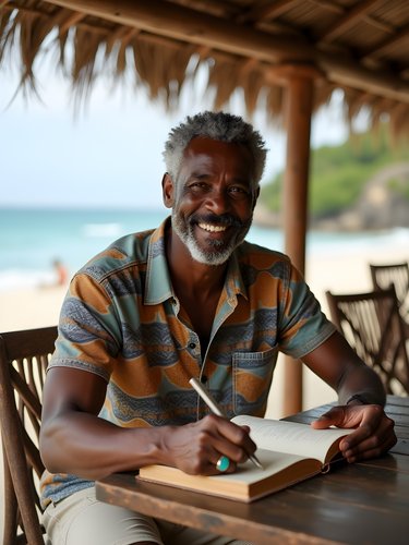
The name 'Guantánamo' often conjures images of a controversial naval base, but this easternmost Cuban province holds natural and cultural treasures that remain largely unexplored by international travelers. As someone who's spent decades studying how humans interact with landscapes across seasons, I found Guantánamo's mountains, caves, and coastal paths to be a living laboratory of both archaeological significance and breathtaking beauty. Join me as I share my winter expedition through trails that tell stories spanning centuries of human habitation, from Taíno indigenous settlements to colonial coffee plantations reclaimed by the wild.

Preparing for Cuba's Forgotten Province
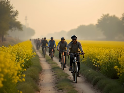
When planning this two-week expedition to Guantánamo's highlands and coastal regions, I quickly discovered that conventional guidebooks barely scratch the surface of what's available to serious hikers. The province's relative isolation—both politically and geographically—has preserved trail systems that remain wonderfully undeveloped yet accessible with proper preparation.
First, understand that this isn't resort Cuba. You'll need proper documentation beyond the standard tourist card, particularly for areas near (but not entering) the restricted zones around the naval base. I secured mine through the Cuban Embassy well in advance, specifying my interest in archaeological hiking.
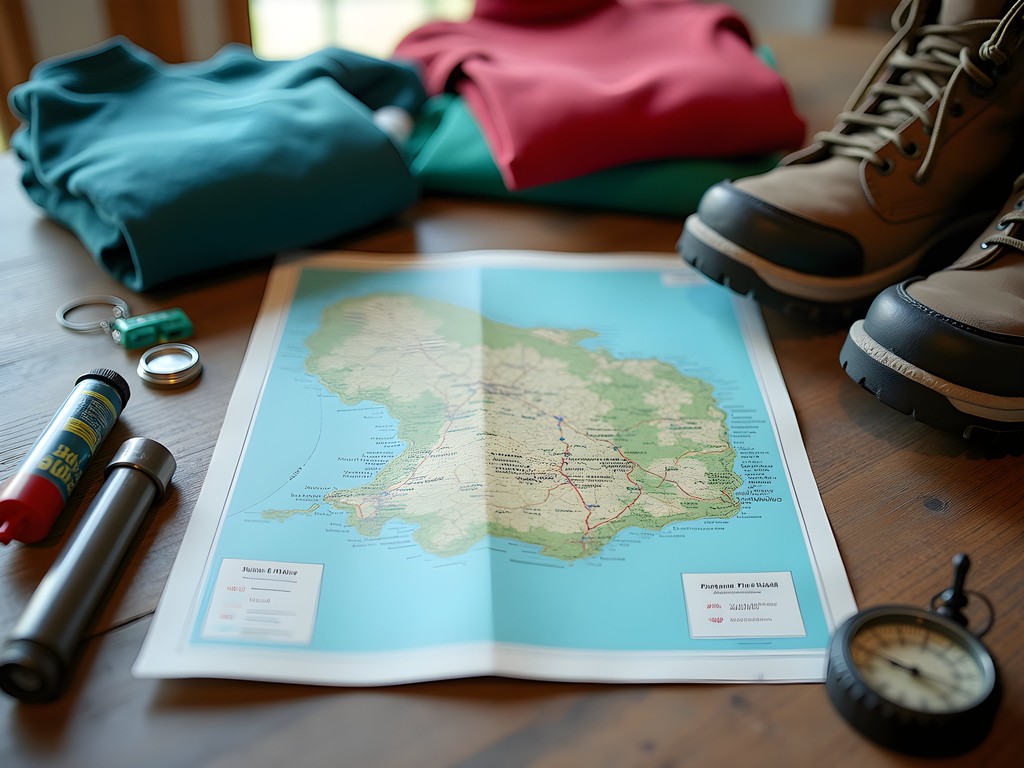
Equipment requirements here differ from what you might pack for the American Southwest or Andean trails. The combination of humidity, unexpected rainfall, and dense vegetation demands specialized gear. My water filter proved invaluable when exploring remote areas where potable water wasn't guaranteed. Similarly, the moisture-wicking shirts I packed performed admirably in the microclimate shifts between coastal paths and mountain ascents.
💡 Pro Tips
- Apply for specific hiking permits at least 3 months before your trip through the Cuban Ministry of Tourism
- Bring twice as much cash as you think you'll need—ATMs are scarce and often unreliable in remote areas
- Pack a physical Spanish-English dictionary; cellular service for translation apps is spotty at best
El Yunque: The Archaeological Ascent
The flat-topped mountain of El Yunque rises like a sentinel from the eastern landscape, visible for miles across Guantánamo Province. While technically part of neighboring Holguín Province, this UNESCO-protected site serves as the perfect starting point for understanding the region's archaeological significance.
The ascent begins gently enough, winding through former coffee plantations established by French colonists fleeing the Haitian Revolution. As a track coach, I've trained athletes to recognize how terrain affects pacing, and that principle applies perfectly to this hike. The initial 3 kilometers lull you with moderate inclines before the trail transforms into a challenging vertical puzzle of limestone outcroppings and exposed roots.
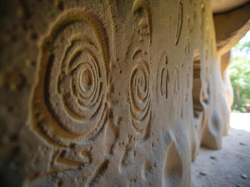
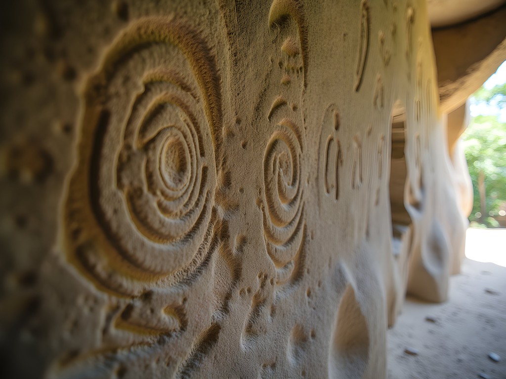
What makes El Yunque exceptional isn't just the physical challenge but the archaeological revelations along the way. Approximately two-thirds up the eastern face, a detour leads to a series of caves containing some of the best-preserved Taíno petroglyphs in the Caribbean. Having studied similar rock art in the American Southwest, I was struck by the symbolic parallels between cultures that never interacted—both using concentric circles to represent water sources and zigzag patterns for lightning or rain.
For this section, my headlamp proved essential for examining cave details while keeping hands free for climbing. The adjustable brightness settings allowed for examining fine petroglyph details without causing excessive light damage to sensitive archaeological features.
💡 Pro Tips
- Start the El Yunque hike no later than 7 AM to avoid afternoon heat and have adequate time for archaeological exploration
- Bring a small offering (flowers or fruit, never manufactured items) as a sign of respect when visiting Taíno sites
- Photograph petroglyphs using natural light when possible; if using artificial light, never use flash
The Coastal Coffee Trail: History Reclaimed by Nature
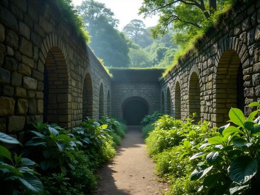
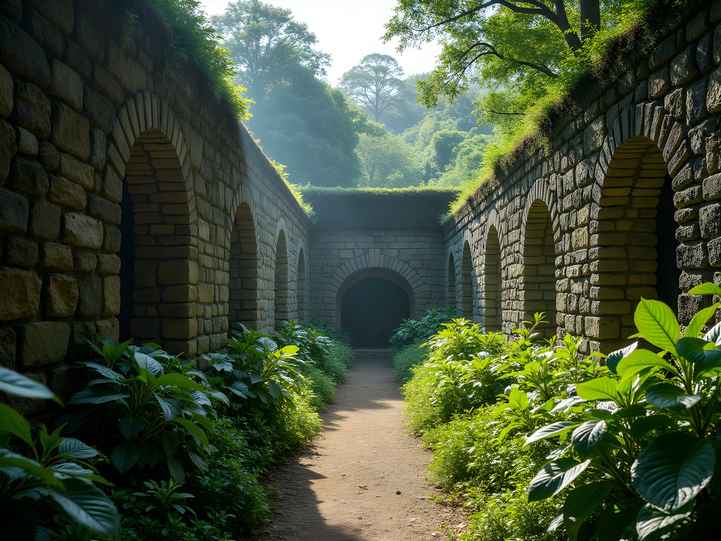
While most visitors to Cuba associate coffee plantations with the western regions around Viñales, Guantánamo Province holds the fascinating remnants of what was once called the Coffee Corridor—a network of French-owned plantations established in the late 18th century.
The 17-kilometer trail connecting these former plantations follows ancient trading routes that predate Columbus, winding through landscapes where nature has steadily reclaimed colonial infrastructure. As someone who studies how sites transform across seasons, I was particularly struck by how the winter dry season reveals architectural features that remain hidden during summer months when vegetation grows unchecked.
The hike begins at the partially restored Hacienda La Isabelica, where original coffee drying platforms provide an excellent vantage point for understanding the plantation's layout. From there, the trail becomes progressively wilder, with rusted processing equipment and crumbling stone walls appearing unexpectedly through the foliage.
The physical demands here differ from mountain hiking. The constant up-and-down of coastal hills combined with humidity requires different preparation. My cooling towel became my constant companion, providing remarkable relief when soaked in the occasional streams crossing the path. For tracking both the official trail and exploring off-shoot paths to hidden ruins, the offline GPS app proved invaluable in areas where cellular service disappeared completely.
💡 Pro Tips
- Hire a local guide from Baracoa who can identify edible plants along the trail—many are descendants of plantation workers with generational knowledge
- Carry at least 3 liters of water per person despite the coastal proximity; freshwater sources are unreliable
- Pack lightweight rain protection even in the dry season; coastal microclimates can bring sudden afternoon showers

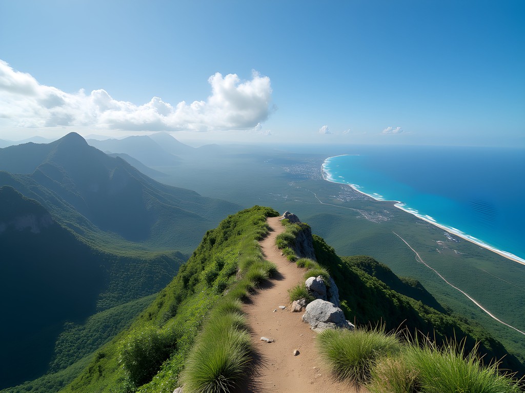
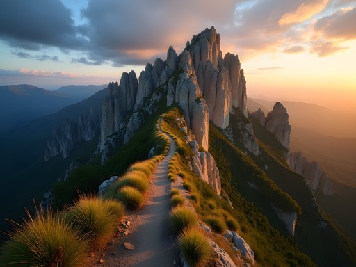
La Gran Piedra: Where Geology Meets History
The most physically demanding trail in Guantánamo Province leads to La Gran Piedra (The Great Rock), an enormous volcanic boulder perched improbably atop a mountain ridge. At 1,234 meters above sea level, the summit offers panoramic views extending from the Sierra Maestra mountains to the Caribbean Sea on clear winter days.
As a former track coach accustomed to analyzing terrain for training advantages, I approached this trail with professional interest. The path ascends through five distinct ecological zones, each requiring different hiking techniques. The initial tropical forest section features relatively gentle slopes but challenging root systems that demand careful foot placement. As you transition to pine forests at higher elevations, the trail steepens dramatically with loose volcanic soil creating treacherous footing.
What makes this hike archaeologically significant are the remnants of cimarron communities—settlements established by escaped enslaved people who fled plantations to create hidden mountain societies. These settlements were strategically positioned near natural caves that provided shelter while remaining invisible from the valleys below. The defensive positioning demonstrates sophisticated understanding of sightlines and natural camouflage.
For this challenging hike, proper footwear is non-negotiable. My hiking boots provided the ankle support and grip needed for the varied terrain. When temperatures dropped unexpectedly near the summit, my packable insulated jacket proved its worth despite adding weight to my pack.
💡 Pro Tips
- Allow a full day (8-10 hours) for the complete La Gran Piedra circuit to avoid dangerous night descents
- Pack layers regardless of valley temperatures; the summit can be 15°F cooler with strong winds
- Respect cimarron historical sites by observing but never removing artifacts—even small pottery shards have archaeological significance
Connecting with Local Communities: The Cultural Dimension
Any archaeological expedition that ignores living cultural contexts misses crucial dimensions of understanding. Throughout my two weeks in Guantánamo Province, I made deliberate efforts to connect with communities maintaining traditional relationships with these landscapes.
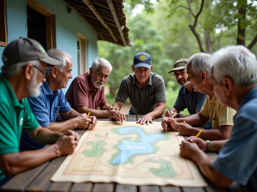
In the mountain village of Yateras, I participated in a community mapping project where elders identified trails used for generations but absent from official maps. These knowledge-keepers shared insights about seasonal changes that affect trail conditions—information no satellite imagery could provide. Their understanding of how water flows change between summer and winter seasons proved invaluable for planning safe river crossings.
Near the coastal areas, I spent two days with a local botanist who specializes in identifying medicinal plants used continuously since pre-Columbian times. This knowledge transmission represents living archaeology—practices maintained across centuries despite colonization and modernization pressures.
For respectful community engagement, communication tools matter. My solar charger kept my translation device powered during multi-day excursions away from electricity. When sharing meals with local families, my travel spice kit became an unexpected conversation starter, allowing me to contribute familiar flavors to communal cooking while learning about local culinary traditions.
💡 Pro Tips
- Learn at least 20 key Spanish phrases focused on asking permission and expressing gratitude before arriving
- Bring printed photographs from your home region to share—this creates reciprocal exchange rather than one-sided observation
- Offer to share meal preparation when staying with local families; participating in daily activities builds meaningful connections
Final Thoughts
Guantánamo Province represents what I've come to value most in my decades of archaeological exploration—landscapes where human history and natural environments remain in conversation across centuries. The trails I've described offer far more than physical challenges; they provide windows into complex cultural narratives that defy simplistic understandings.
As climate change accelerates and political situations evolve, these fragile archaeological contexts face uncertain futures. The coastal trails particularly show signs of erosion that threaten to erase evidence of both indigenous and colonial histories. My hope is that responsible travelers will contribute to preservation efforts by hiring local guides, respecting site boundaries, and supporting community-based tourism initiatives that value cultural heritage.
For those willing to venture beyond the familiar Cuban tourism circuits, Guantánamo's trails offer rewards that transcend typical travel experiences. The physical demands of these hikes create natural limitations that have, ironically, helped preserve their authenticity. In a world where overtourism threatens so many significant sites, these paths remain places where discovery still feels personal and meaningful. The question isn't whether you should explore Guantánamo's hidden trails, but rather: are you prepared for how they might change your understanding of Cuban history, archaeological preservation, and your own relationship with landscapes shaped by human hands across time?
✨ Key Takeaways
- Guantánamo Province offers archaeological hiking experiences that remain largely undiscovered by international tourists
- Winter provides optimal hiking conditions with clear visibility and access to sites that may be obscured by vegetation in other seasons
- Connecting with local communities enhances both the cultural understanding and practical safety of remote trail exploration
📋 Practical Information
Best Time to Visit
December through March (dry season)
Budget Estimate
$1,500-2,500 for two weeks (excluding international flights)
Recommended Duration
Minimum 10 days, ideally 14-16 days
Difficulty Level
Challenging


Comments
Casey Andersson
Jamie, this brought back so many memories! I visited Guantánamo Province last March and it was genuinely one of the most underrated places I've explored in the Caribbean. El Yunque was spectacular at sunrise—we started the hike at 5am to beat the heat and the views from the top were absolutely worth the early wake-up call. The archaeological sites along the trail were fascinating, and our local guide shared stories about the indigenous Taíno people that you just can't get from guidebooks. One tip for anyone planning this: bring plenty of water and snacks. There are no facilities on the trails and the humidity is intense. Also, hiring a local guide isn't just recommended, it's essential—the trails aren't well-marked and they know all the hidden viewpoints. Such an incredible adventure off the beaten path!
vacationmood
5am hike sounds brutal but those sunrise views must be incredible!
oceanphotographer
How hard is it to actually get to Guantánamo Province? Did you fly or take buses from Havana?
Casey Andersson
Not the author but I went last year! We flew from Havana to Santiago de Cuba then hired a driver. Takes about 2 hours by car. The roads are rough but totally worth it.
oceanphotographer
Thanks! How much did the driver cost roughly?
Casey Andersson
Around $80 USD for the day. We negotiated to have him wait while we hiked El Yunque too.
vacationmood
Never even thought about Cuba for hiking! This looks amazing
redqueen
These photos are stunning! Never knew this side of Cuba existed. The mountain shots especially are gorgeous.
Frank Carter
For anyone planning to visit, I'd recommend spending at least 4-5 days in the province. The distances are deceptive and roads can be challenging. I found the best approach was to base myself in Baracoa and take day trips from there. The local transportation is an adventure in itself - shared taxis and camiones give you a real sense of daily Cuban life. Also, brush up on your Spanish if possible. English is much less common here than in Havana or Varadero, but that's part of the authentic experience. The warmth of the people more than makes up for any language barriers.
Hayden Butler
Jamie, this is such an important piece. I visited Guantánamo Province three years ago and was blown away by how few travelers make it out there. The province has this raw, untouched quality that's increasingly rare in Caribbean destinations. I stayed at a beautifully restored colonial house in Baracoa and hired a private guide for La Gran Piedra - the sunrise from the top was one of those moments that reminds you why we travel. The French coffee plantation ruins scattered throughout the mountains tell such a poignant story of the Haitian revolution's ripple effects. It's encouraging to see more writers highlighting this region beyond the political narrative.
Jamie Owens
Completely agree, Hayden. Those plantation ruins are hauntingly beautiful. The way nature has reclaimed them over two centuries creates this incredible atmosphere.
backpackqueen1777
Going to Cuba in March!! Adding this to my list
skylover
I visited Baracoa last year and absolutely fell in love with the area! We did a shorter hike near the coast but didn't make it to the coffee trail you mentioned. The whole region feels so different from Havana and Viñales - way more lush and tropical. The people were incredibly welcoming too. Wish I'd had more time to explore properly.
Frank Carter
Baracoa has such a distinct culture! The blend of Taíno, African, and Spanish influences is really fascinating. Did you get to try the local chocolate?
skylover
Yes! The cacao tour was amazing
travelnomad
El Yunque is incredible. Did it back in 2019.
happypro4901
Wow never thought about Guantánamo as a travel spot! Do you need special permits to visit this area? I've heard eastern Cuba can be tricky to access for tourists. Also how did you arrange guides for the trails?
Jamie Owens
No special permits needed! You can travel freely throughout Guantánamo Province as a tourist. I arranged my guide through a casa particular in Baracoa - the host connected me with a local who knew El Yunque really well.
happypro4901
Thanks! That's really helpful
Venture X
Premium card with 2X miles, $300 travel credit, Priority Pass