


Disclosure: This article contains affiliate links. We may earn a commission from purchases at no extra cost to you, which helps our travel content.
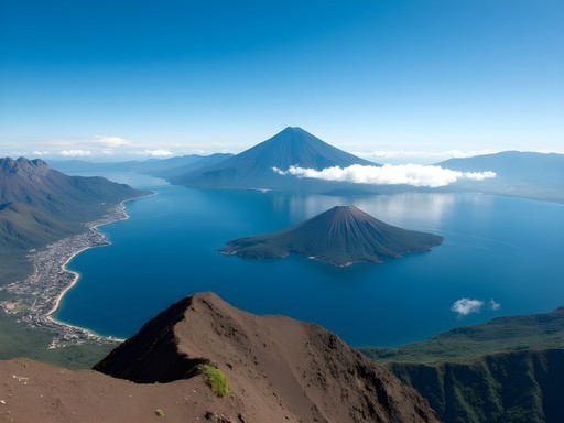
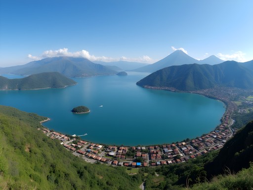
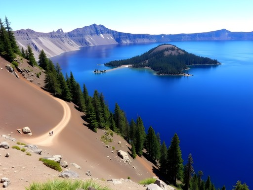
The first time I laid eyes on Lake Atitlan, I swear my soul did a little shimmy. Standing on that ridge after a dusty bus ride from Antigua, watching the late afternoon light dance across water so deeply blue it looked almost painted, with three perfect volcanoes standing sentinel—I knew I'd stumbled onto something special. Y'all, this ain't just any lake. The legendary writer Aldous Huxley called it 'the most beautiful lake in the world,' and after spending a week circumnavigating its shores on foot, documenting both its natural wonders and the vibrant Mayan communities that call it home, I'm inclined to agree. As someone who's hiked everywhere from the post-industrial ruins of Pittsburgh to the mountain lakes of Switzerland, I can tell you with absolute certainty: the trails around Lake Atitlan offer something truly unique—a perfect confluence of natural splendor, living indigenous culture, and the kind of vistas that make you question whether you're looking at reality or some fantastic painting come to life.

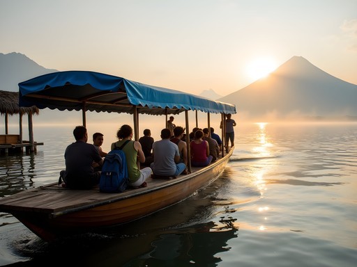
Indian Nose: The Sunrise Spectacle
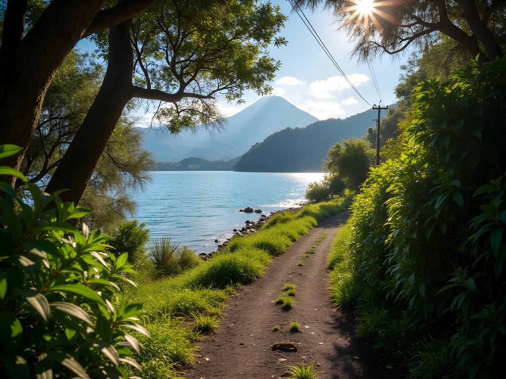
They call it the Indian Nose (or Rostro Maya) because the mountain ridge resembles the profile of a sleeping Mayan face looking skyward—something I wouldn't have noticed if my guide hadn't pointed it out at 4:30 AM as we began our ascent by headlamp. This pre-dawn hike from the village of Santa Clara La Laguna isn't particularly long (about 30-45 minutes of actual climbing), but what it lacks in distance it makes up for in pure magic.
The trail begins with a gentle incline through milpa fields—traditional Mayan agricultural plots where corn, beans, and squash grow together in beautiful symbiosis. As the path steepens, pine forests appear, filling the dark morning air with their resinous scent. I'd recommend bringing a reliable headlamp since you'll be navigating rocky sections in near darkness.
When I reached the summit just before 6 AM, I joined a handful of other travelers sitting in reverent silence. As the first light broke, the lake revealed itself—a mirror reflecting the perfect cones of the three volcanoes (San Pedro, Toliman, and Atitlan). The villages dotting the shoreline began to glow gold in the morning light, and wisps of fog danced across the water's surface.
What made this experience particularly special was watching my guide, a young Tz'utujil Maya man, perform a brief sunrise ceremony—a reminder that these landscapes aren't just pretty views but deeply sacred spaces that have shaped Mayan cosmology for millennia.
💡 Pro Tips
- Hire a local guide for safety and cultural context—prices range from Q100-150 ($13-20)
- Bring layers! The summit is chilly before sunrise, even in winter
- Pack a small breakfast to enjoy at the top while watching the light show
Volcano San Pedro: The Classic Challenge
If there's one hike that's on everybody's Lake Atitlan bucket list, it's climbing Volcano San Pedro. Standing at 9,908 feet (3,020 meters), this perfectly conical volcano dominates the southern shore of the lake and offers what might be the most spectacular panoramic view in all of Guatemala.
I started my ascent from the village of San Pedro La Laguna, where you'll need to pay an entrance fee (Q100/$13) at the nature reserve office. The trail begins deceptively gentle, winding through coffee plantations where farmers were harvesting the bright red cherries. The rich smell of soil and coffee mingled in the air as birds darted between the shade trees—a reminder that these working landscapes are also vibrant ecosystems.
About an hour in, things get serious. The trail transforms into a relentless upward climb through cloud forest that had me questioning my life choices. The vegetation shifts dramatically as you ascend—from the agricultural zone through dense, misty forest draped with orchids and bromeliads, and finally to pine forest near the summit.
After about 3-4 hours of climbing (I'm not too proud to admit I took frequent breaks), I emerged onto the summit ridge to find myself literally above the clouds. The entire lake spread out below me, with villages appearing like tiny model sets and the neighboring volcanoes of Toliman and Atitlan looming close enough to touch. The descent took me about 2.5 hours, and my knees were mighty grateful for my trekking poles which saved me from turning into a wobbly mess on the steep downhill sections.

💡 Pro Tips
- Start by 7 AM at the latest to avoid afternoon clouds obscuring the view
- Bring at least 2-3 liters of water—there's nowhere to refill on the trail
- Hiring a guide is recommended for safety (robberies have occurred on this trail)
Jaibalito to Santa Cruz: The Lakeside Ramble
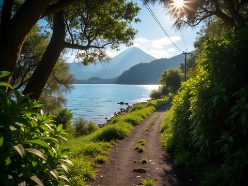
Not every worthwhile hike around Lake Atitlan requires scaling a volcano. One of my favorite days was spent walking the northern shore trail between the tiny village of Jaibalito and Santa Cruz La Laguna. This relatively flat 45-minute walk offers some of the most spectacular lakeside views you'll find anywhere.
I started in Jaibalito, a charming hamlet with no road access (you can only reach it by boat or on foot), where I fueled up with fresh coffee at Posada Jaibalito. The trail hugs the lakeshore, sometimes just feet from the water's edge, passing through private properties (don't worry, locals are accustomed to hikers passing through), small coffee plantations, and sections of lush vegetation.
What makes this hike special is how intimate it feels—you're walking through people's backyards, greeting local Maya women washing clothes at the lakeshore, passing fishermen mending their nets, and catching glimpses of hummingbirds darting between flowering bushes. The views across to the volcanoes remain constant companions.
Midway through the hike, I stumbled upon a small rocky beach where I couldn't resist taking a refreshing dip in the lake's cool waters. My quick-dry towel came in handy here—it's lightweight enough to carry on any day hike but absorbent enough to get you dry quickly.
Arriving in Santa Cruz, I treated myself to lunch at CECAP, a vocational training restaurant where local Maya youth learn culinary skills. The food was delicious, but the real reward was the satisfaction of having experienced the lake from a perspective most visitors miss—at water level, where daily life unfolds at its own unhurried pace.
💡 Pro Tips
- Wear water shoes or sandals with good grip—parts of the trail can be muddy or rocky
- Bring swimwear for impromptu lake dips along the way
- Time your hike to end in Santa Cruz for lunch at CECAP, which supports local education

Los Tarrales Reserve: The Birdwatcher's Dream
Sometimes you need to step away from the lake to truly appreciate its magnificence. Los Tarrales Nature Reserve, located on the southern slopes of Volcano Atitlan about an hour's drive from Panajachel, offers exactly that opportunity—plus some of the best bird watching in Central America.
As someone who's spent years documenting scientific collections, I found Los Tarrales to be a living museum of biodiversity. The reserve spans multiple ecological zones, from coffee plantations at lower elevations up through cloud forest. I arranged a guided hike through my hostel in Panajachel (though you can also contact the reserve directly), and it was worth every quetzal.
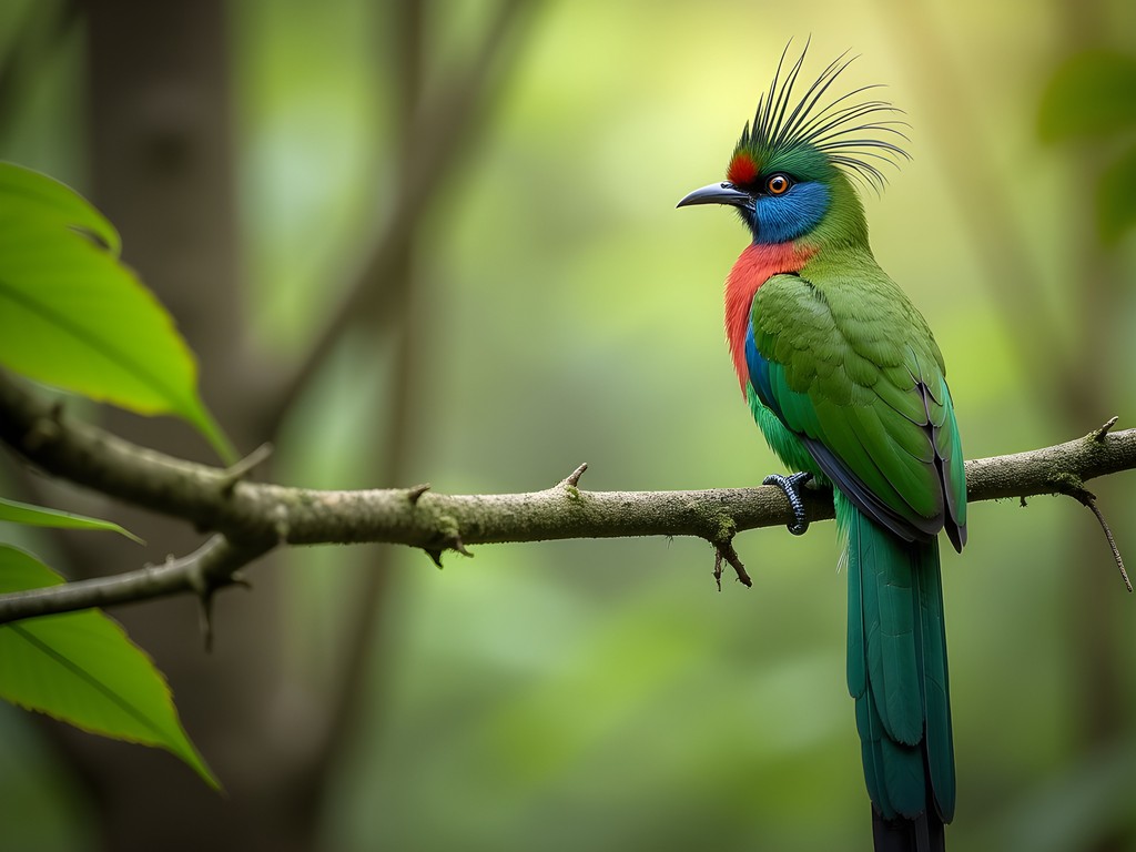
My guide, Don Chus, has been spotting birds here for over 30 years, and his eyes seemed supernaturally attuned to movement in the canopy. Within the first hour, we'd spotted resplendent quetzals (yes, the mythical bird that adorns Guatemala's currency), several species of toucans, and countless hummingbirds. I was grateful for my binoculars which offered crystal clear views even in the dappled forest light.
The hiking itself ranges from moderate to challenging, depending on which trail you choose. I opted for the mid-elevation route, which climbs through old-growth forest to a series of waterfalls. The real magic happened when we reached a clearing with a view back toward Lake Atitlan—the massive blue expanse framed by forest, with all three volcanoes visible in perfect alignment.
What struck me most was the contrast between the wild, untamed nature of Los Tarrales and the cultivated, village-dotted landscape around the lake itself. Both beautiful, but in completely different ways—like comparing a formal garden to a wilderness. This hike offered a critical piece of context for understanding the lake's ecosystem and the pressures it faces from development and agriculture.
💡 Pro Tips
- Book a guide in advance—their expertise in spotting wildlife is invaluable
- Start early (6-7 AM) when birds are most active
- Wear long pants and bring insect repellent—the lower elevations can have mosquitoes
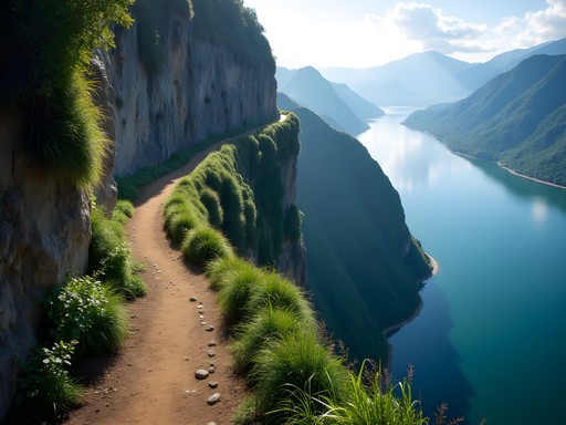
Tzununa to San Marcos: The Cliff-Hugging Adventure
For those seeking a bit of adrenaline with their lake views, the trail connecting Tzununa and San Marcos La Laguna delivers in spades. This section of the north shore trail is considerably more adventurous than the Jaibalito to Santa Cruz stretch, with portions literally carved into steep cliffs dropping straight into the lake.
I began in the small village of Tzununa (accessible by public boat from Panajachel) after enjoying breakfast at Bambu Guest House. The trail starts innocuously enough, passing through small farm plots and backyard gardens, but soon begins to climb above the lakeshore. About 15 minutes in, you reach the first of several narrow cliff-side passages where the path has been reinforced with concrete in some sections.
The views are absolutely spectacular—perhaps the best on the lake—as you're elevated just enough to take in the perfect panorama of water and volcanoes, but still close enough to hear the lapping of waves below. I passed several local Maya farmers carrying impossibly large bundles of firewood or produce on their backs, navigating the narrow paths with practiced ease while I hugged the mountain side of the trail.
About halfway through the hike, I discovered a series of small platforms built into the cliffside—meditation spaces created by spiritual seekers drawn to San Marcos' reputation as a healing center. I took a moment to sit, breathe, and simply absorb the majesty of the landscape. My travel journal came out here, as some views simply demand to be recorded in both images and words.
The trail eventually descends into San Marcos La Laguna, arguably the most picturesque village on the lake with its car-free pathways, spiritual centers, and stunning natural surroundings. The entire hike takes only about an hour, but packs in enough visual splendor for a full day. I celebrated my arrival with a fresh smoothie at Moonfish Café before exploring the village's hidden garden sanctuaries.

💡 Pro Tips
- Not recommended during or immediately after heavy rain when trails can be slippery
- Wear shoes with good grip—flip flops are a definite no-go here
- Consider hiring a local guide if you're uncomfortable with heights
Santa Catarina Palopó Loop: The Cultural Immersion
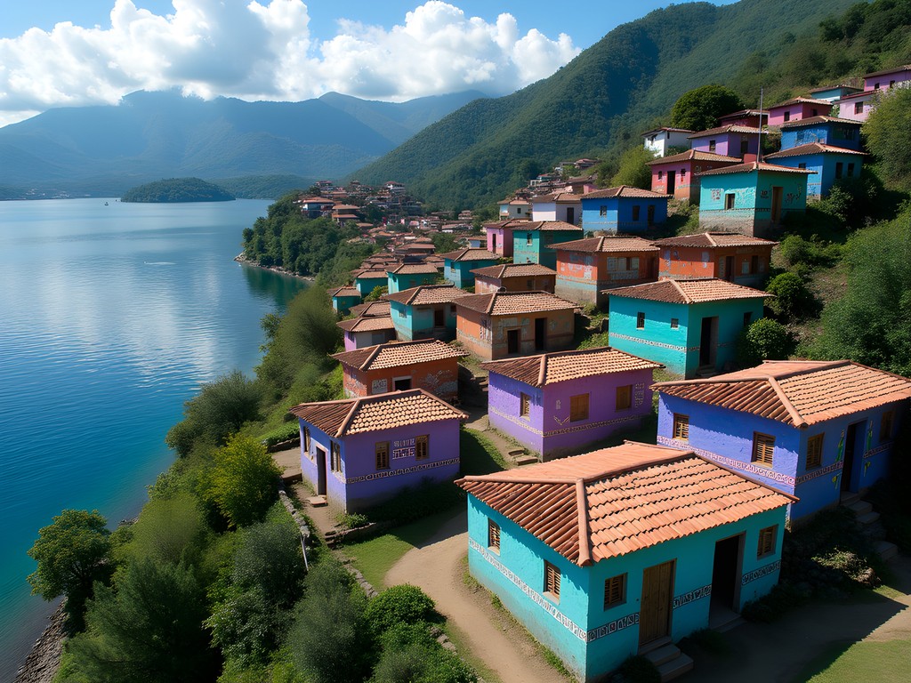
Not all memorable hikes need to be challenging wilderness adventures. One of my most rewarding days around Lake Atitlan was spent on a gentle loop hike through and above the village of Santa Catarina Palopó, famous for its houses painted in stunning geometric patterns inspired by traditional Kaqchikel Maya textiles.
I arrived in Santa Catarina by tuk-tuk from Panajachel (a quick 10-minute ride) and began by simply wandering the steep, narrow streets of the village. Every turn revealed new visual delights—buildings painted in vibrant blues, purples, and teals adorned with symbols representing elements of Maya cosmology. This community art project, called Pintando Santa Catarina Palopó, began as a way to attract tourism and has transformed the village into a living canvas.
After exploring the lower village, I followed a cobblestone path uphill, passing women weaving on backstrap looms in doorways and children playing with homemade kites. The path eventually turns into a dirt trail that loops above the village, offering spectacular views of the painted houses below with the lake and volcanoes beyond.
What makes this hike special isn't physical challenge but cultural immersion. I stopped frequently to chat with locals (my rudimentary Spanish supplemented by smiles and gestures), purchased a small textile directly from the woman I watched create it, and even got invited into a family compound to see how traditional blouses (huipiles) are made.
The loop eventually brought me back down to the lakeshore, where I relaxed at a small public beach. The entire walk took only about 2-3 hours, including all my stops and conversations, making it perfect for a morning excursion. This is the kind of experience that reminds me why I travel—not just to see beautiful landscapes, but to witness how communities express their identity and traditions through art and daily life.
💡 Pro Tips
- Bring small bills to purchase directly from artisans if something catches your eye
- Learn a few basic Kaqchikel Maya phrases (not just Spanish) for meaningful interactions
- Consider hiring a local guide for deeper cultural context about the painted symbols
Cerro de Oro: The Forgotten Pyramid
For my final Lake Atitlan hike, I wanted something off the typical tourist path. Cerro de Oro (Hill of Gold) delivered exactly that—an archaeological site-meets-natural-viewpoint that sees a fraction of the visitors of other lake attractions.
This distinctive rounded hill on the southeastern shore of the lake resembles a sleeping elephant (or a turtle, depending who you ask) and holds significant importance in Maya mythology. I took a public pickup truck from Santiago Atitlan to the small village of Cerro de Oro at the base of the hill, where I hired a local guide named Miguel.
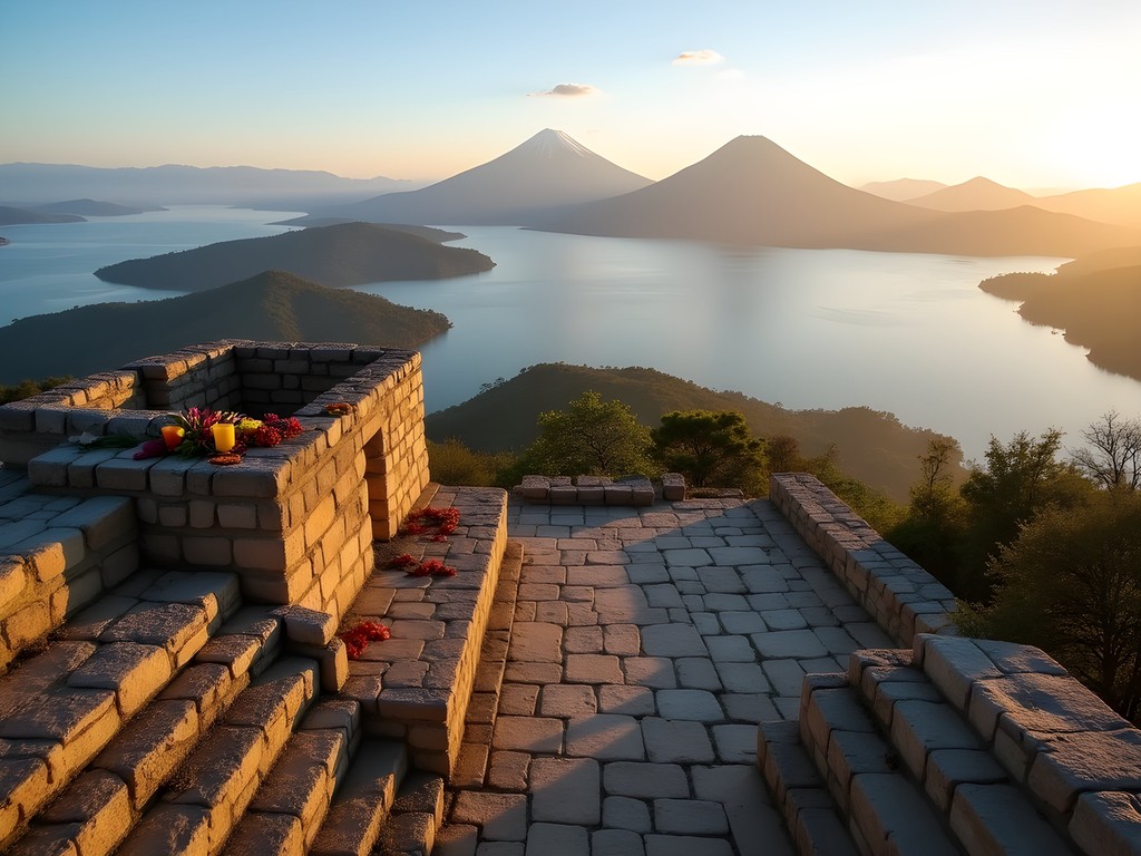
The trail begins by winding through cornfields and coffee plantations before starting a moderately steep ascent up ancient stone pathways. What makes this hike unique is that the entire hill contains the remains of a Maya ceremonial center, with terraces and platforms built into the hillside. Miguel pointed out architectural features I would have completely missed on my own—collapsed chambers, ceremonial platforms, and agricultural terraces dating back over a thousand years.
After about an hour of climbing, we reached the summit, which features the remains of a pyramid structure and several ceremonial platforms. The 360-degree views are nothing short of spectacular—the entire lake basin spreads out below, with all three main volcanoes visible plus the often-forgotten Volcano Tolimán. On clear days, you can even see the Pacific Ocean in the distance.
What struck me most was the profound silence. Unlike Indian Nose or San Pedro, I shared the summit with only my guide and the occasional soaring hawk. Miguel explained that the site remains actively used for Maya ceremonies, and indeed we saw evidence of recent offerings—flowers, candles, and the distinctive circular burn patterns of sacred fires.
The descent follows a different path down the northern face of the hill, completing a loop back to the village. The entire hike takes only about 2-3 hours, but delivers archaeological intrigue and panoramic views that rival much more challenging treks.
💡 Pro Tips
- Always hire a local guide—the site has cultural significance and guides share important historical context
- Bring extra water as there's little shade on the upper portions
- Visit in the morning for the clearest views before afternoon clouds roll in
Final Thoughts
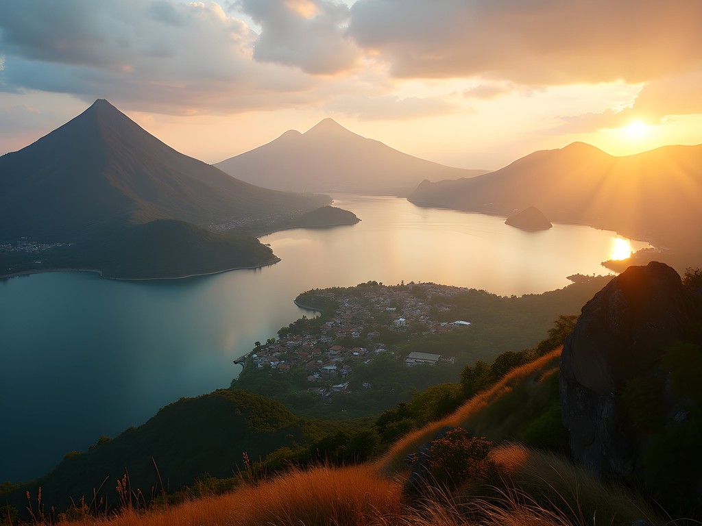
As I took my final lancha boat ride across Lake Atitlan, watching the late afternoon light turn the water to liquid gold, I found myself already plotting my return. Each hike around this magnificent crater lake offers something completely different—from heart-pumping volcano ascents to gentle cultural strolls, from bird-filled forests to ancient Maya ruins. What unites them all is the ever-present backdrop of what might truly be the most beautiful lake on earth. In my travels documenting natural and cultural heritage around the world, I've rarely encountered a place where landscape, indigenous culture, and accessible adventure converge so perfectly. Whether you're a serious trekker looking to bag volcanic peaks or a curious wanderer seeking cultural connection, Lake Atitlan's network of trails offers a journey for every spirit. Just remember to tread lightly, hire local guides when possible, and take the time to learn about the living Maya cultures that give this landscape its soul. The mountains are calling, y'all—and trust this Southern boy when I say, these highlands have stories worth hearing.
✨ Key Takeaways
- Lake Atitlan offers hikes for all ability levels, from challenging volcano climbs to gentle cultural walks
- Hiring local Maya guides provides crucial safety information and cultural context that transforms the experience
- The best views often come from less-visited spots like Cerro de Oro rather than the most popular tourist trails
📋 Practical Information
Best Time to Visit
November through February (dry season with clearest views)
Budget Estimate
$30-50/day including accommodations, food, and guides
Recommended Duration
5-7 days to experience multiple trails without rushing
Difficulty Level
Varies From Easy (Village Walks) To Challenging (Volcano Climbs)
Comments
Claire Hawkins
Beautiful post, Corey! Lake Atitlan holds such a special place in my heart. We spent two weeks there last summer and did most of these hikes. One thing I'd add about the Los Tarrales Reserve - if you're into birdwatching, go SUPER early! We arrived at 6am and saw quetzals, motmots, and dozens of hummingbirds. The biodiversity is incredible. For anyone planning a trip, I'd recommend staying in different villages around the lake. Each has its own personality! San Marcos was perfect for yoga and relaxation, while San Pedro had the best nightlife and food options. The lake has such magical energy - I'm already planning our return trip next year!
smartzone
Which of these hikes would be best with kids? We have a 7 and 10 year old and want something scenic but not too challenging.
Corey Kelly
The Jaibalito to Santa Cruz lakeside ramble would be perfect for kids! It's relatively flat, has beautiful views the whole way, and plenty of places to stop for snacks or a swim. My friend's kids (6 and 8) loved spotting different birds and butterflies along the path. Just bring good sun protection!
smartzone
Thanks Corey! That sounds perfect for us. Can't wait to visit!
hikingguy
Just got back from Lake Atitlan and did the Indian Nose sunrise hike. AMAZING experience but a word of warning - it gets cold up there in the early morning! I was shivering in just a light jacket. The sunrise was absolutely worth the 4am wake-up call though. I used my headlamp for the dark parts of the trail and it was perfect. One tip: arrange your transportation back to your hotel beforehand. We got stuck negotiating with tuk-tuk drivers in the dark!
smartzone
Thanks for the tip about the cold! Did you feel safe doing the hike? I've read mixed things about safety in the area.
hikingguy
We went with a local guide which is definitely recommended! Never felt unsafe but wouldn't do it alone. Our hotel in San Pedro arranged everything for us.
tripfan
How difficult is the San Pedro volcano hike? I'm planning to visit in November but I'm not super fit. Would I still be able to make it to the top?
Claire Hawkins
I did San Pedro last year with my husband and 12-year-old daughter! It's challenging but doable if you take it slow. Just start early (around 7am) to avoid the midday heat. The views are absolutely worth it! We took about 3 hours up and 2 down. Bring plenty of water and snacks!
tripfan
Thanks Claire! That's really helpful. Did you use a guide or is the trail well-marked?
Claire Hawkins
Definitely get a guide! It's required anyway for safety reasons. We paid about 150Q per person (around $20) which included the park entrance fee. Our guide Miguel was fantastic with the kids too!
sunnyzone
Great post! How did you get between the different trailheads? Did you base yourself in one town or move around? We'll have about 5 days at the lake in January.
Corey Kelly
For 5 days, I'd recommend splitting your time between Panajachel (good base for San Pedro volcano and Los Tarrales) and either San Marcos or Santa Cruz (for the lakeside trails and Indian Nose). The public lanchas (boats) are cheap and run frequently until about 5pm between all the lake villages. For Indian Nose, you'll need to arrange transportation from your hotel since it starts very early!
sunnyzone
Perfect, thanks so much! We'll probably do 2 nights in Pana and 3 in San Marcos then.
Amit Sullivan
Wonderful post that brought back such memories! I spent three weeks around Lake Atitlan in 2023, and the Los Tarrales Reserve was an unexpected highlight. For any birders reading this, I spotted 27 species in a single morning hike, including the elusive Resplendent Quetzal! The guide made all the difference - ask for Eduardo if he's still working there. He has ears like a bat and can identify birds by the faintest calls. One trail not mentioned that I'd add: the path from San Marcos up to the viewpoint above town. It's a short but steep 30-minute climb that gives you a completely different perspective of the lake's western basin. I went at sunset with my compact binoculars and watched the villages light up one by one as darkness fell. Pure magic!
roamlife
The San Marcos viewpoint sounds amazing! Adding that to my list for sure. How hard was the climb? I'm not super fit...
Amit Sullivan
It's steep but short - about 30 minutes up if you take it slow. There are a few spots to rest with benches. Definitely doable if you're not in top shape, just take your time!
nomadzone
How safe is it to hike these trails solo? Planning a trip for early next year and wondering if I need to join guided tours or if some are okay alone?
sunnyzone
I did the Jaibalito to Santa Cruz trail solo last year and felt completely safe. It's well-traveled and follows the lake. But for Volcano San Pedro and Indian Nose, definitely get a guide - both for safety and because finding the trailheads can be tricky.
Corey Kelly
Great question! I'd echo what sunnyzone said - the lakeside trails between villages are generally fine solo during daylight hours, but the volcano hikes and Indian Nose are better with guides. Local guides are affordable (around $15-25) and their knowledge really enhances the experience anyway!
nomadzone
Thanks both! That's super helpful. I'll plan to do the lakeside trails solo and budget for guides on the others.
roamlife
Those photos are STUNNING! Adding Lake Atitlan to my bucket list right now!
mountainbackpacker
Indian Nose sunrise was the highlight of my Guatemala trip last year! Got there super early (3:30am start) and it was absolutely worth the early wake-up call. The colors over the lake were unreal. One tip though - it gets COLD up there before sunrise, way colder than you'd expect in Guatemala. Bring layers! I made the mistake of just wearing a light jacket and was shivering the whole time.
Amit Sullivan
Couldn't agree more about the layers! When I hiked Indian Nose in 2023, I brought my trusty merino wool base layer and was so glad I did. The temperature swing from pre-dawn to mid-morning is dramatic.
mountainbackpacker
Wish I'd been that smart, Amit! Definitely learned my lesson for future sunrise hikes.
traveladventurer
Going to Guatemala in October! How hard is the San Pedro hike for someone with moderate fitness? And is it easy to find guides once you're there or should I book ahead?
bluemaster7641
Did it last year. It's tough but doable if you pace yourself. Plenty of guides in San Pedro town - just ask at your hostel.
Corey Kelly
Hey there! San Pedro is challenging but definitely doable with moderate fitness. Plan for 4-5 hours round trip and take plenty of breaks. You'll find guides easily in San Pedro town (around 100-150Q), no need to book ahead. October should have amazing weather too! Let me know if you have any other questions!
traveladventurer
Thanks so much! Can't wait to check it out!
Venture X
Premium card with 2X miles, $300 travel credit, Priority Pass