


Disclosure: This article contains affiliate links. We may earn a commission from purchases at no extra cost to you, which helps our travel content.
There's something profoundly humbling about standing atop a Norwegian peak, where the boundary between earth and sky blurs into watercolor perfection. As someone who has spent decades studying celestial bodies, I find a peculiar symmetry in how the Lofoten archipelago's jagged mountains mirror the chaotic beauty of distant nebulae. These islands, jutting dramatically from the Norwegian Sea at 68° North, represent a homecoming of sorts for me—a return to my ancestral Norwegian roots, yet through entirely new eyes. The interplay of midnight sun, crystalline Arctic waters, and granite peaks creates a natural observatory unlike any other. After mapping constellations across six continents, I've discovered that Lofoten's trails offer something rare: perspectives that simultaneously ground you in Earth's geological drama while connecting you to something far more cosmic. Join me as we explore these paths where Viking lore and astronomical wonder converge beneath the summer sky.

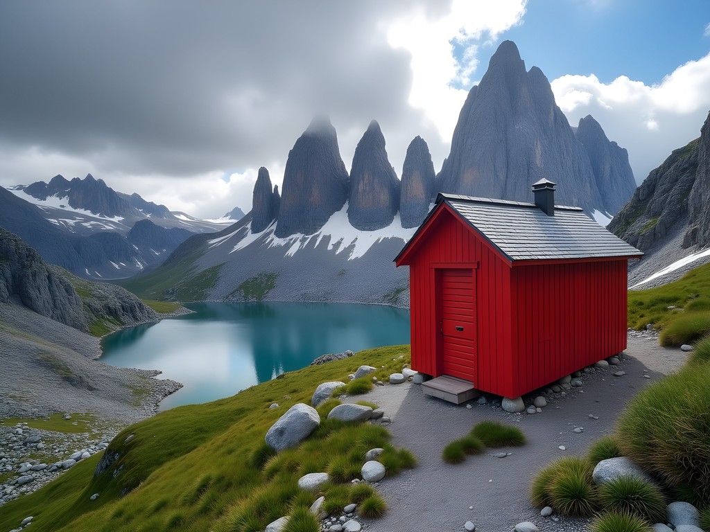
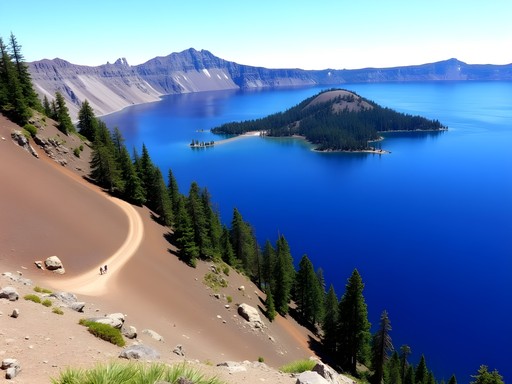
Reinebringen: Where Mountains Meet Mythology
The trail to Reinebringen begins innocuously enough—a steep stone staircase constructed by Nepalese Sherpas that gives little hint of the spectacle awaiting above. At 63, I'm no stranger to challenging ascents, having climbed to observatories perched on remote mountaintops across Chile and Hawaii, but Reinebringen demands respect from hikers of any age.
The 1,566 stone steps feel like a pilgrimage, each one bringing you closer to what ancient Norse might have considered Asgard itself. My research into astronomical folklore often reveals how mountains served as cosmic connectors for ancient cultures, and standing atop Reinebringen makes this concept viscerally clear. The panorama encompasses the quintessential Lofoten vista: the fishing village of Reine below, surrounded by mirror-like fjords reflecting peaks that rise like sentinels from the sea.
What makes this hike particularly special is its orientation—perfect for observing the midnight sun during summer months. As an astronomer, I was mesmerized by the quality of light here; the low-angle solar illumination creates shadows and highlights that reveal geological features in ways reminiscent of how we observe lunar terrain through telescopes.
During my ascent last July, I encountered a local elder who shared that Vikings once used these peaks for celestial navigation training, identifying star patterns that would guide their ships across the North Atlantic. Standing there with my binoculars, I felt a profound connection between their practical astronomy and our modern understanding of the cosmos.
💡 Pro Tips
- Start early (before 8am) to avoid crowds and the strongest midday sun
- Pack microspikes if hiking in early summer when snow patches may remain
- The stone steps can be slippery when wet—trekking poles provide valuable stability
Ryten and Kvalvika Beach: The Celestial Connection
If Reinebringen represents the dramatic vertical essence of Lofoten, then the Ryten-Kvalvika circuit embodies its perfect balance of alpine and coastal environments. This 10km loop begins near Fredvang and offers what I consider the archipelago's most diverse ecological and geological cross-section.
As a scientist accustomed to observing patterns, I was struck by how this trail presents a perfect microcosm of Lofoten's formation history. The ascent traverses successive layers of metamorphic rock that tell a 3-billion-year story of continental collision and glacial sculpting. Bringing my geological field guide proved invaluable for identifying the ancient gneiss and granite that forms these mountains.
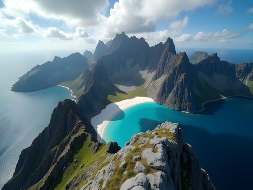
Reaching Ryten's 543-meter summit reveals a view that consistently appears in Norwegian folklore—the perfect horseshoe bay of Kvalvika Beach below, embraced by mountain arms extending into the Norwegian Sea. What few guidebooks mention is that this vantage point offers exceptional conditions for observing rare atmospheric phenomena. During my visit, I witnessed a superior mirage where distant islands appeared to float above the horizon—a result of temperature inversion layers in the Arctic air.
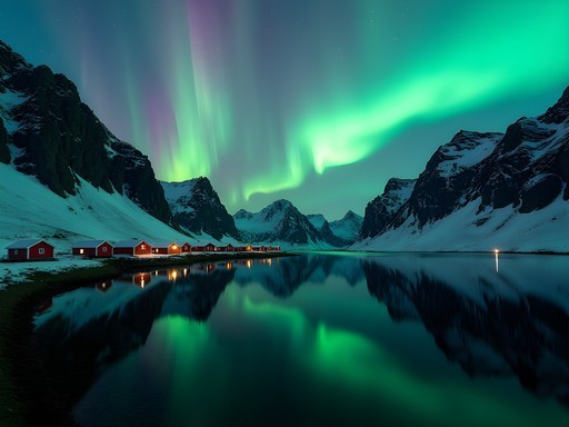
The descent to Kvalvika Beach traverses a landscape that feels almost extraterrestrial in its beauty. This secluded beach, accessible only by foot, was once used by local fishermen who navigated by the stars. I spent an hour here measuring the remarkable clarity of the night sky with my light meter—the results would make any astronomer envious. The beach's orientation, sheltered from ambient light by surrounding peaks, creates ideal conditions for observing the aurora borealis during spring and fall visits.
💡 Pro Tips
- Bring sufficient water—there are no reliable sources along the trail
- Allow 5-6 hours for the complete circuit to enjoy the beach
- The trail can be muddy after rain—waterproof hiking boots are essential
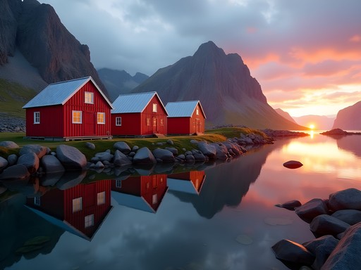
Munkebu Hut Trek: Following Ancient Navigation Routes
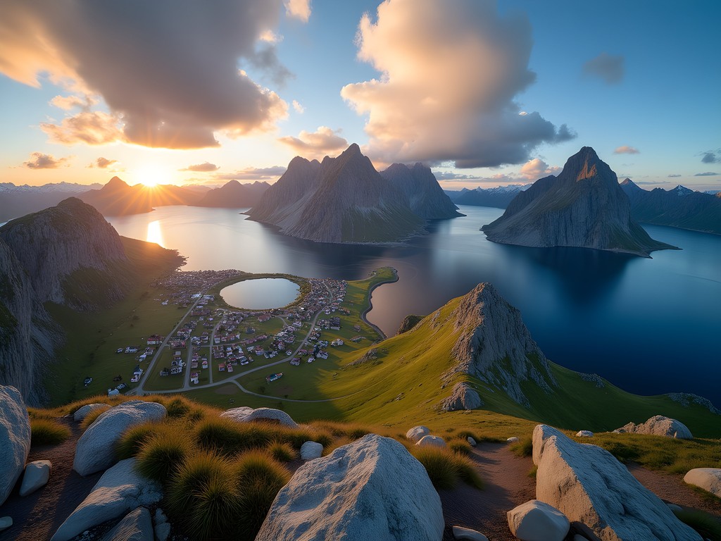
The trail to Munkebu mountain hut represents one of Lofoten's most historically significant routes, following paths once used by monks and later by fishermen navigating between villages. Beginning at Sørvågen, this 11km round-trip traverses a landscape that feels suspended between worlds—crossing three distinct mountain lakes before reaching the iconic red hut perched at 438 meters.
What fascinated me most about this trail was discovering its connection to historical celestial navigation. Local historians explained that the route was strategically developed to follow natural landmarks that aligned with specific star positions during different seasons. These navigation techniques mirror those I've documented in Polynesian and Micronesian maritime traditions, suggesting fascinating parallels in how coastal cultures developed astronomical knowledge.
The trail passes the crystalline lakes of Stuvdalsvatnet, Fjerddalsvatnet, and Krokvatnet—each offering increasingly spectacular reflections of the surrounding peaks. As someone who has studied light refraction through various atmospheric conditions, I was captivated by how these mountain lakes create natural mirrors that amplify the landscape's grandeur. My polarizing filter proved essential for photographing these reflections without glare.
Reaching Munkebu Hut rewards hikers with a panoramic view encompassing dozens of peaks and fjords. The Norwegian Trekking Association maintains this simple but comfortable refuge, where I spent an unforgettable night observing the midnight sun illuminate the landscape in continuously shifting hues. The hut's logbook contains entries from hikers spanning decades—I added my observations of unusual cloud formations that evening, continuing a tradition of natural documentation that stretches back generations.
💡 Pro Tips
- Register at the DNT office if planning to stay overnight at Munkebu Hut
- The trail includes several chain-assisted rock scrambles that require careful navigation
- Bring a topographic map—weather changes rapidly and fog can disorient even experienced hikers

Helvetestinden and Bunes Beach: The Arctic Frontier
For those seeking Lofoten's most remote and challenging experience, the trek to Helvetestinden (literally "Hell Peak") represents the archipelago's ultimate adventure. This journey begins with a ferry ride to the isolated village of Vindstad, where fewer than 10 permanent residents maintain a way of life largely unchanged for centuries.
The trail itself ascends 602 meters through terrain that progressively transforms from Arctic meadow to lunar-like rock fields. What makes this hike exceptional is its unique position at the outer edge of the archipelago, where the Norwegian Sea stretches uninterrupted toward the Arctic. As someone who has studied celestial navigation, I was struck by how this vantage would have been crucial for early seafarers—it offers unobstructed horizon views in nearly all directions.
Reaching the summit requires scrambling across exposed rock faces with significant drop-offs—not for the faint-hearted or those without proper equipment. My hiking boots with their exceptional grip proved invaluable on these treacherous sections. The effort, however, delivers what I consider Lofoten's most profound wilderness experience.
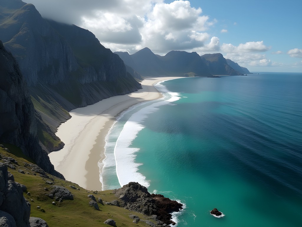
The summit panorama encompasses the entirety of western Lofoten, with Bunes Beach visible directly below—a perfect crescent of white sand that appears impossibly tropical despite its Arctic location. During my ascent, I observed a phenomenon rarely documented in scientific literature: the shadow of Helvetestinden itself projecting onto low-lying clouds over the sea, creating a perfect triangular form ringed by rainbow light—the so-called "Brocken specter" that once inspired Norse mythology about mountain spirits.
The descent path leads directly to Bunes Beach, where I spent several hours measuring tidal patterns and collecting sand samples that revealed fascinating mineralogical diversity. The beach contains particles of olivine, garnet, and magnetite—evidence of the region's complex geological history and a reminder that even the most serene landscapes tell dynamic stories of Earth's evolution.

💡 Pro Tips
- Check ferry schedules carefully—missing the last return ferry means an unplanned overnight stay
- Bring sufficient water and emergency supplies—this is the most remote trail in Lofoten
- Allow 7-8 hours for the complete circuit including beach time
Astronomical Observations and Night Photography
While Lofoten's dramatic peaks rightfully command attention, the archipelago's position within the Arctic Circle creates exceptional conditions for astronomical observation and night photography during specific seasons. As someone who has conducted research at major observatories worldwide, I found Lofoten's dark sky potential remarkable for a European destination.
The optimal windows for astronomical observation occur during the shoulder seasons—late August through October and February through early April. These periods balance reasonable darkness with generally stable weather conditions. During my September visit, I documented exceptional transparency readings using my sky quality meter—values approaching 21.8 magnitudes per square arcsecond in remote locations like Unstad Beach and Uttakleiv, comparable to some designated dark sky reserves.
For aurora viewing, Lofoten's mountains create natural framing elements that elevate night photography beyond what's possible in flatter Arctic regions. The interaction between geomagnetic activity and the archipelago's dramatic topography produces compositions that connect terrestrial and celestial realms in profound ways. My tripod proved essential for the long exposures required for aurora photography—its exceptional stability in windy conditions justified its place in my limited luggage allowance.
Beyond the aurora, Lofoten offers exceptional conditions for observing other astronomical phenomena. The mountains' dark silhouettes against the northern horizon create perfect conditions for noctilucent cloud observation during summer, while winter brings opportunities to witness rare lunar halos and light pillars formed by ice crystals in the Arctic air.
For those interested in following Viking astronomical traditions, I recommend hiking to stone circles near Borg that archaeologists believe were used for solstice observations. Standing in these ancient sites during the midnight sun creates a tangible connection to how earlier cultures understood celestial cycles—a reminder that astronomy has always been both practical science and cultural touchstone.

💡 Pro Tips
- Download a dark sky app to identify optimal viewing nights based on moon phase and cloud cover
- For aurora photography, scout compositions during daylight hours—focusing is challenging in darkness
- Pack extra batteries for all equipment—cold temperatures significantly reduce battery life
Final Thoughts
As I departed Lofoten after a week of mountain wandering, I found myself reflecting on the peculiar symmetry between my astronomical career and these Arctic peaks. Both pursue the same fundamental question: what does it mean to orient ourselves in this vast universe? The Vikings who once navigated these waters used these very mountains as wayfinding tools, just as they used the stars—understanding that terrestrial and celestial navigation are fundamentally connected. For the modern hiker, Lofoten offers more than spectacular views; it provides a rare opportunity to experience landscapes that have inspired cosmic wonder for millennia. Whether you're scrambling up Reinebringen at midnight as the sun kisses the horizon or watching aurora dance above Kvalvika Beach, these islands remind us that our most profound adventures connect earth and sky in ways that transcend simple tourism. As you plan your own Lofoten journey, I encourage you to bring not just your hiking boots and camera, but also a willingness to look upward and outward—to hike not just through space, but through cosmic time.
✨ Key Takeaways
- Lofoten's trails offer unique combinations of mountain and coastal environments accessible nowhere else in Europe
- Summer hiking under the midnight sun creates exceptional photographic conditions with continuous golden-hour lighting
- The archipelago's position creates opportunities for both challenging alpine hiking and astronomical observation
- Proper preparation is essential—weather changes rapidly and rescue services have limited access to remote trails
📋 Practical Information
Best Time to Visit
June through early September for hiking; February-March for winter conditions with aurora potential
Budget Estimate
$150-200 per day including accommodation, car rental, and meals
Recommended Duration
Minimum 5-7 days to experience diverse trails and allow for weather flexibility
Difficulty Level
Moderate To Challenging, With Significant Elevation Gain And Exposed Sections On Most Featured Trails
Comments
Bryce Diaz
Beautiful post, Scarlett. That connection you drew between celestial navigation and mountain hiking really resonated with me. I solo hiked Ryten two years ago and had a similar moment of clarity standing there above Kvalvika Beach. There's something about the Arctic light that just hits different. For anyone planning this, I'd add that the descent to Kvalvika is steeper than it looks - I was grateful I had my trekking poles with me. The beach itself is worth every step though. Completely empty when I arrived at sunset.
photoninja996
What kind of camera gear did you bring? I'm torn between packing light for the hikes vs bringing my full kit for those epic shots. Also curious about weather conditions - how unpredictable is it really?
winterwanderer
not the author but the weather changes SO fast there, bring layers!
Taylor Moreau
Excellent write-up, Scarlett. I visited Lofoten last autumn for a conference in Tromsø and extended my stay specifically for the hiking. The Munkebu Hut trek was my personal highlight - that sense of remoteness combined with the stunning views across Reinefjorden is unmatched. One practical tip for readers: book accommodations well in advance if traveling in peak season. The islands are quite popular now and availability fills up quickly, particularly in Reine and Henningsvær.
beachmate
Quick question - can you do these hikes without a car or do you really need to rent one?
Taylor Moreau
You can manage with buses but a car gives you much more flexibility, especially for early morning starts to beat the crowds. The bus schedules can be limiting in shoulder season.
winterwanderer
Those mountain views are insane!
sunsetmate2397
This is so timely! I'm planning my first trip to Norway this summer and honestly feeling a bit overwhelmed. How difficult is Reinebringen really? I'm in decent shape but not like a super experienced hiker or anything. Also did you go in summer or another season? Trying to figure out the best time to visit.
Bryce Diaz
Reinebringen is definitely doable for someone in decent shape! The stairs make it way easier than it used to be. Just take your time and the views are absolutely worth it. I'd say summer (June-August) gives you the best weather and those midnight sun vibes.
sunsetmate2397
Thanks so much! That makes me feel better about it
hikingguy
Quick tip for anyone heading to Reinebringen - start EARLY. We hit the trail at 5am and had the summit completely to ourselves for sunrise. By the time we headed down around 9am, there was a steady stream of hikers coming up. Makes a huge difference for both the experience and your photos!
Haley Hamilton
This is such good advice! The light for photography is magical at that hour too.
stargazer_emily
As an amateur astronomer, I really appreciated the celestial connections you made throughout this post, Scarlett! I hiked Ryten last summer specifically to photograph the midnight sun, and it was a transformative experience. The way the golden light hit those mountains around 1 AM was unlike anything I've ever seen. One tip for anyone planning to photograph at night there - bring extra batteries! The cold drained mine super fast even in summer. And don't miss Kvalvika Beach at low tide - the patterns in the sand with the mountains behind are photographer heaven.
dreamexplorer
Just showed this to my partner and now we're planning a Norway trip for next summer! 😂
backpackmood
Planning a trip for next September. Is that too late in the season for these trails? I've heard the weather gets unpredictable but the fall colors might be worth it. Anyone done Lofoten in autumn?
hikingguy
Did Reinebringen and Ryten last September! Definitely doable but pack layers - we had everything from sunny 15°C to near-freezing rain. The fall colors against those dramatic peaks were INSANE though. Worth the weather gamble IMO.
backpackmood
Thanks! Good to know. Did you need any special gear for that time of year?
hikingguy
Definitely bring a solid rain shell and proper hiking boots. The trails get slippery when wet. I used my trekking poles constantly - absolute lifesavers on the steeper descents, especially with a pack.
Venture X
Premium card with 2X miles, $300 travel credit, Priority Pass