


Disclosure: This article contains affiliate links. We may earn a commission from purchases at no extra cost to you, which helps our travel content.
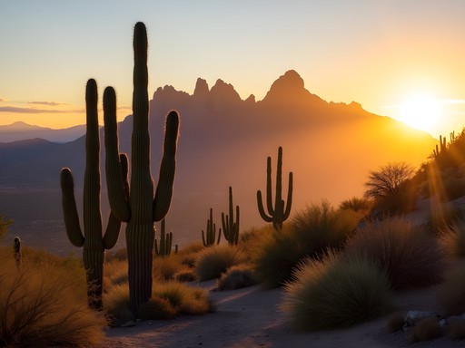
As someone who spends her professional life creating order from chaos, there's something deeply satisfying about the structured beauty of Arizona's desert landscapes. The geometric precision of cacti silhouetted against watercolor sunsets, the methodical layering of sedimentary rock formations, and the carefully evolved ecosystem that thrives in Mesa's arid climate – it all speaks to my organizer's soul. Last fall, while extending a business trip organizing an executive retreat in Phoenix, I discovered Mesa's network of trails offers the perfect balance of accessibility and adventure. Whether you're a solo traveler seeking solitude or looking to maximize a quick weekend escape, these ten hikes deliver breathtaking views, fascinating desert ecology, and that rare sense of both freedom and focus that only nature provides. Each trail has been meticulously researched and personally tested, because if there's one thing I've learned from years of professional organizing and travel planning – efficiency matters, especially when you've got limited time to experience something extraordinary.

Lost Dutchman State Park: Treasure Loop Trail
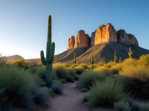
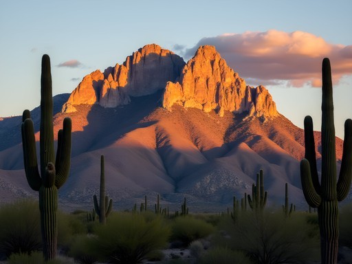
The Superstition Mountains have long captivated visitors with legends of hidden gold, but the real treasure here is the 2.4-mile Treasure Loop Trail that offers spectacular views without demanding extreme fitness. During my visit last October, I arrived at sunrise (a professional organizer's habit of maximizing daylight) and was rewarded with the Superstition Mountain's dramatic façade glowing amber in the morning light.
The trail begins with a gentle ascent through classic Sonoran Desert landscape, where saguaro cacti stand like sentinels against the sky. About halfway through, you'll reach a natural viewpoint that frames the valley floor perfectly – an ideal spot for contemplation or photography. The trail is exceptionally well-marked, a detail I particularly appreciate as someone who values efficiency in navigation.
I found myself completely alone for the first hour, with only the occasional jackrabbit and cactus wren for company. The silence was profound – a rare commodity in our hyper-connected world. By the time I completed the loop, the day's heat was just beginning to build, and I was grateful for my early start and the hydration pack that kept me properly hydrated without having to stop and fumble with water bottles.
For those interested in the area's history, the park's visitor center offers excellent exhibits on the legendary Lost Dutchman's gold mine and the geological forces that shaped this striking landscape.

💡 Pro Tips
- Start early (before 8 AM) to avoid heat and crowds
- The park entrance fee is $7 per vehicle – bring exact cash
- Look for the rare crested saguaro cactus about halfway through the loop
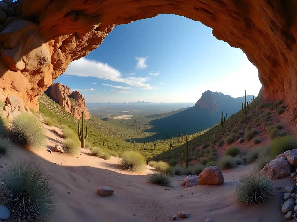
Usery Mountain Regional Park: Wind Cave Trail
If you're seeking the perfect balance between challenge and accessibility, Wind Cave Trail delivers with its 3.2-mile round-trip journey to a fascinating geological feature. The trail gradually ascends 800 feet along the eastern edge of Pass Mountain, offering increasingly expansive views of the valley below.
What makes this hike particularly special is the microclimate created at the wind cave itself – a concave depression in the mountain face where cooler air circulates, supporting unique plant life not found elsewhere on the trail. During my hike last November, the temperature dropped noticeably as I approached the cave, a welcome respite from the desert heat.
The trail's surface changes dramatically as you ascend – starting with packed earth and transitioning to more technical rocky sections near the top. I was thankful for my hiking boots which provided the ankle support and grip needed for the varied terrain.
As a professional organizer, I appreciate how well this trail maximizes the experience-to-effort ratio. In just under two hours of moderate hiking, you're rewarded with panoramic views of the entire East Valley, from the Goldfield Mountains to the distant Phoenix skyline. The geological storytelling is exceptional too – each layer of rock represents millions of years of Earth's history, organized in visible strata that satisfy my love for natural classification systems.
I timed my descent to coincide with the golden hour, when the valley below was bathed in warm light and the shadows created dramatic contrasts across the desert floor. If you're a photography enthusiast, this timing is absolutely worth planning for.
💡 Pro Tips
- The wind cave faces east, so afternoon visits offer shade and better photography lighting
- Bring binoculars to spot desert wildlife and distant landmarks
- The park's entrance fee ($7) is well worth it for the well-maintained facilities
San Tan Mountain Regional Park: Goldmine Trail
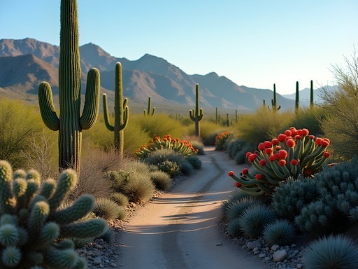
Some trails reveal their character gradually, and the Goldmine Trail is a perfect example of this slow-burning charm. Located in the less-frequented San Tan Mountain Regional Park, this 4.5-mile loop offers a quieter desert experience than some of Mesa's more popular hiking destinations.
What struck me immediately was the diversity of cacti along this route. Beyond the iconic saguaros, you'll encounter teddy bear cholla, barrel cacti, and my personal favorite – the ocotillo, which resembles a bouquet of slender stems reaching skyward. During my hike last October, many were crowned with brilliant red blooms, adding vibrant color to the desert palette.
The trail's name comes from an actual historic gold mining operation, and attentive hikers can spot evidence of this industrial past about halfway through the loop. I found myself fascinated by the resilience of nature reclaiming these human interventions – a reminder that our organizational systems are always temporary in the grand scheme of things.
The highlight comes at the trail's highest point, where a natural rock formation creates a perfect resting spot with 360-degree views. I spent nearly an hour here, organizing my thoughts in my travel journal, sketching the landscape, and enjoying the solitude that's increasingly rare in our connected world.
What makes Goldmine Trail particularly suitable for solo travelers is its moderate traffic – enough people that you don't feel isolated from a safety perspective, but sparse enough that you can enjoy extended periods of solitude and reflection. The trail is also exceptionally well-marked with frequent directional signs, making navigation straightforward even for those hiking alone.

💡 Pro Tips
- The park entrance is less obvious than others – use GPS coordinates rather than the park name
- Bring polarized sunglasses to fully appreciate the mineral variations in the rock formations
- Check at the visitor center for information about seasonal wildflower blooms

Hawes Trail System: Ridge Line Trail
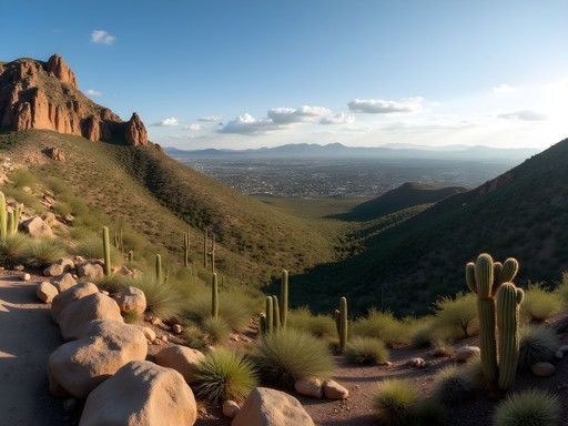
For intermediate hikers seeking a more technical experience, the Ridge Line Trail in the Hawes Trail System delivers both challenge and reward. Unlike the more developed parks, this network of trails on the northeastern edge of Mesa offers a rawer desert experience with fewer facilities but more adventure.
The Ridge Line Trail stretches approximately 4.8 miles along an elevated ridge of the Usery Mountains, providing continuous panoramic views that shift with every turn. What makes this trail particularly special is how it balances on the literal edge between wilderness and civilization – to one side stretches the undeveloped desert, while the other offers views of Mesa's urban landscape.
As someone who appreciates efficient systems, I was impressed by how this trail maximizes elevation gain through thoughtful routing rather than punishing climbs. The path undulates along the natural contours of the ridge, creating a rhythm of effort and recovery that feels sustainable even in the desert heat.
The trail surface here is primarily decomposed granite and rocky outcroppings, requiring more attention to foot placement than some of Mesa's more manicured paths. My trekking poles proved invaluable for maintaining balance on the occasional loose sections, especially during steep descents.
What truly distinguishes Ridge Line is the sense of immersion in the landscape. Without the infrastructure of state parks, you experience the desert in a more intimate way – from the subtle variations in rock coloration to the surprising diversity of desert plants adapting to microclimates along the ridge.
During my solo hike, I encountered several red-tailed hawks riding thermals along the ridge – a mesmerizing display of efficiency in motion that had me stopping repeatedly to watch their graceful navigation of invisible air currents.

💡 Pro Tips
- There's limited parking at the trailhead – arrive early or on weekdays
- No facilities are available, so bring all necessary water and supplies
- Download the trail map before you go as cell service can be spotty
Usery Mountain: Pass Mountain Trail
When I need to clear my mind and reset my organizational thinking, I seek out loop trails that offer a complete journey rather than an out-and-back experience. The Pass Mountain Trail delivers this perfectly with its 7.4-mile circuit around the mountain that shares its name.
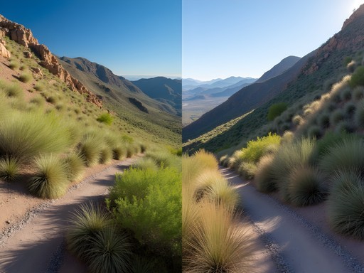
What makes this trail special is how it showcases the desert's surprising diversity. The north face of Pass Mountain harbors significantly different plant communities than the south face – a textbook example of how exposure and microclimate shape ecosystems. As someone who appreciates efficient natural systems, I found this variation fascinating.
The trail begins with a moderate climb through classic Sonoran Desert landscape, with saguaros and palo verde trees dominating the scene. As you curve around to the mountain's north side, the environment shifts dramatically – more moisture-loving plants appear, and the temperature can drop several degrees. This natural organization of plant life based on environmental factors resonates with my professional perspective on creating functional systems.
About halfway through the loop, the trail offers spectacular views of Four Peaks and the Superstition Mountains in the distance. I found a perfectly positioned boulder for a lunch break and spent nearly an hour absorbing the panorama while refueling with trail snacks I had meticulously packed in my hiking daypack – which has brilliantly designed compartments that keep everything accessible without unpacking.
The western portion of the loop provides views of Mesa and the greater Phoenix area, creating a satisfying contrast between wilderness and civilization. I completed the hike just before sunset, when the city lights began to twinkle in the distance while the desert was bathed in that magical golden hour light photographers chase.
What makes Pass Mountain ideal for solo hikers is its moderate popularity – you're never completely alone (a safety consideration), but the trail rarely feels crowded. The clearly marked path and reasonable difficulty level make it accessible for intermediate hikers looking for a substantial but not overwhelming challenge.

💡 Pro Tips
- Allow 4-5 hours to complete the full loop at a comfortable pace
- The north side offers welcome shade during midday heat
- Bring a wide-brimmed hat as much of the trail offers limited shade
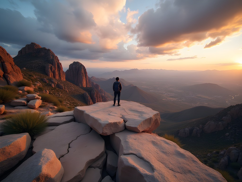
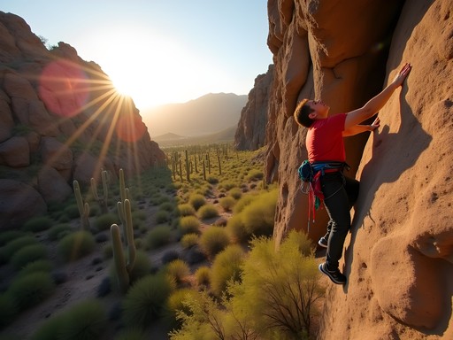
Siphon Draw to Flatiron Summit
I'm a firm believer in pushing boundaries – in business and in nature – which is why I've saved the most challenging hike for last. The Siphon Draw to Flatiron Summit trail is not for casual hikers, but for those with experience and determination, it delivers an experience that transcends the ordinary.
Beginning at the Lost Dutchman State Park, this 6-mile round-trip trail gains over 2,700 feet in elevation, much of it in steep, rocky sections that require careful navigation and occasional hand-over-foot scrambling. The trail begins innocuously enough on the well-maintained Siphon Draw Trail, but soon transitions into a more primitive path as it enters the dramatic canyon that gives the trail its name.
What makes this hike exceptional is the dramatic transformation of landscapes as you ascend. The journey begins in classic Sonoran Desert surroundings, transitions through a remarkable slickrock basin (the 'draw' itself), continues up increasingly steep terrain, and culminates at the massive Flatiron summit – a plateau that seems to have been cleaved from the mountain with a giant axe.
During my ascent last fall, I encountered several points where the trail required problem-solving rather than simple following – a mental exercise I found invigorating. The final approach to the summit involves navigating a near-vertical chute that demands concentration and proper technique. My hiking gloves proved essential for gripping the rough rock surfaces without abrasion – a small investment that significantly enhanced both safety and comfort.
The summit itself is otherworldly – a massive flat expanse of rock with 360-degree views that extend to distant mountain ranges on clear days. I spent nearly two hours exploring the summit plateau, finding quiet corners away from other hikers where I could absorb the magnitude of the landscape in solitude.
The descent demands as much attention as the ascent, particularly in the steeper sections where loose rock can create hazards. I was grateful for having researched proper downhill hiking techniques before attempting this trail – facing outward on the steepest sections and using controlled slides in some areas proved most effective.
💡 Pro Tips
- Start no later than 7AM to avoid dangerous afternoon heat and potential thunderstorms
- Bring at least 3 liters of water per person – there are no water sources on the trail
- Allow 6-8 hours for the complete journey including rest stops
Final Thoughts
Mesa's desert trails offer more than just exercise – they provide a masterclass in natural organization, resilience, and efficiency. From the perfectly adapted plant communities to the geological processes that shaped these landscapes over millions of years, each hike tells a story of systems working in harmony. As a professional organizer who's constantly seeking balance between structure and flexibility, I find these desert landscapes to be profound teachers. Whether you have a single morning or an entire weekend, Mesa's trails can accommodate your schedule while delivering experiences that will recalibrate your perspective. I encourage you to approach these hikes with both preparation and openness – plan your routes, bring appropriate gear, but also allow yourself to be surprised by the desert's subtle wonders. The trails will be waiting for you, organized by nature's patient hand, ready to reveal their secrets one step at a time.
✨ Key Takeaways
- Start hikes early in the morning to avoid heat and crowds
- Each trail offers unique geological and botanical features worth taking time to observe
- Mesa's variety of trails accommodates different fitness levels and time constraints
📋 Practical Information
Best Time to Visit
October through April, with November being ideal
Budget Estimate
$20-50 per day (park fees, transportation, and supplies)
Recommended Duration
2-3 day weekend
Difficulty Level
Intermediate


Comments
coolmaster
Going there next month with friends. Are these trails well marked? We're decent hikers but don't want to get lost in the desert lol. Also any recommendations for where to stay in Mesa?
globewanderer8156
They're all pretty well marked! Just download offline maps to be safe. Cell service can be spotty.
globewanderer8156
Just got back from Usery Mountain and the wildflowers are starting to pop! If you're going in the next few weeks, you might catch the desert bloom. Wind Cave Trail was busier than expected on a Saturday but totally worth it. The cave itself is more of an alcove but the views are stunning. Pro tip: park opens at 6am and the lot fills up fast on weekends. We got there at 6:15 and snagged one of the last spots.
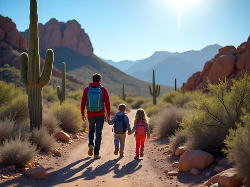
Savannah Torres
We discovered Lost Dutchman last spring with our two kids (ages 8 and 11), and it became our favorite family adventure of the year. The Treasure Loop Trail has this wonderful balance - challenging enough to feel like an accomplishment but manageable for younger hikers. My daughter collected different shaped rocks along the way and we turned it into a geology lesson. The ranger station has great educational materials too. We started at 6:30am to beat the heat and packed frozen water bottles that thawed as we hiked. By the time we finished around 10am, the bottles were perfectly cold. The views at the top made my son say it looked like a movie set. Definitely want to try Wind Cave next time!
coolmaster
The frozen water bottle trick is genius! Stealing that idea for our trip.
adventurephotographer
Been shooting in this area for years and you nailed the best trails. One tip for photographers - the Hawes system gets crowded on weekends but weekday mornings you'll have it almost to yourself. I always pack my hydration pack because temps can spike fast even in winter. The Ridge Line Trail has some killer composition opportunities where the trail curves around those rock formations. Anyone tried the full loop at San Tan? Thinking about tackling it next month.
globephotographer
Those saguaro shots are gorgeous!
beachmaster
Never hiked in the desert before - how hard is the Goldmine Trail for beginners? I'm used to coastal walks but this looks really different. Also is March too hot already?
Savannah Torres
March is actually perfect! We took our kids on Goldmine Trail in early April and it was great for beginners. Bring way more water than you think you need though - the dry air is deceptive.
beachmaster
Thanks! That's really helpful.
Sarah Powell
Ashley, I appreciate how you framed these trails through the lens of natural organization. I did the Treasure Loop Trail solo last fall and was struck by how the terrain naturally guides you through different ecosystems. The elevation gain is moderate but steady - took me about 3.5 hours with plenty of photo stops. One thing I'd add: the best light for photography is definitely that first hour after sunrise. The way the sun hits the Superstition Mountains is incredible. Did you encounter any wildlife on the Ridge Line Trail? I'm planning to return in late spring.
adventurephotographer
Totally agree on the sunrise timing! I've caught some roadrunners and a few desert cottontails on Ridge Line. Early morning is key for wildlife.
escapevibes7925
Wind Cave Trail is amazing! Did it last year.
nomadmate
Going there next month!! So excited after reading this!
vacationking
Same! Maybe we'll cross paths on the trails lol
Olivia Sanchez
Ashley, I love how you captured the 'structured beauty' of the desert - that's such a perfect description! I tackled the Hawes Ridge Line Trail last October during a Southwest adventure trip and the 360-degree views from the top were absolutely worth the climb. One thing I'd add for fellow adventurers: the trail markers can be sparse in some sections, so download an offline map beforehand. I use my GPS device on exposed trails like this where phone batteries drain fast in the heat. Also saw a roadrunner and three different types of lizards - the wildlife encounters alone made it memorable!
Venture X
Premium card with 2X miles, $300 travel credit, Priority Pass