


Disclosure: This article contains affiliate links. We may earn a commission from purchases at no extra cost to you, which helps our travel content.
There's something deeply satisfying about exploring a waterfront city without the constraints of a car. East Providence—Rhode Island's often overlooked gem—reveals itself differently when experienced at a human pace. After years of designing spaces that people rush through, I've developed an appreciation for slow travel that allows true connection with both built environments and natural landscapes. This past summer, I challenged myself to navigate East Providence exclusively by bike and ferry for a weekend, discovering how this industrial-turned-artistic waterfront city breathes when you move through it mindfully.

Planning Your Car-Free Adventure
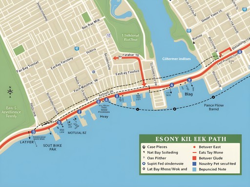
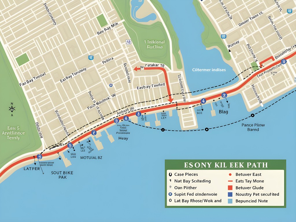
East Providence sits at the convergence of the Providence and Seekonk Rivers, making it uniquely positioned for water-based transportation. Before arriving, I mapped out my weekend using the Rhode Island Public Transit Authority (RIPTA) app and the seasonal ferry schedule.
The city's relatively compact waterfront district means most attractions fall within a 3-mile radius—perfect for cycling exploration. I opted to bring my own folding bike, but visitors can easily utilize the regional bike share program, which has several docking stations throughout East Providence and neighboring Providence.
For accommodation, I chose the historic Wannamoisett House B&B, a mid-19th century home within walking distance of both the ferry terminal and the East Bay Bike Path. At $105/night including breakfast, it offered both character and convenience without breaking my budget. If you're bringing your own bike, consider packing a lightweight bike lock that provides peace of mind when exploring the city's cafes and museums.
💡 Pro Tips
- Download the RIPTA app before arrival for real-time bus tracking
- Purchase a 3-day RIPTA pass ($10) if planning to use buses frequently
- Book accommodations within walking distance of the East Bay Bike Path for maximum flexibility
The East Bay Bike Path: Rhode Island's Waterfront Artery
The crown jewel of car-free travel in East Providence is undoubtedly the East Bay Bike Path. This 14.5-mile rail trail connects Providence to Bristol, with East Providence serving as the first major section. The path hugs the eastern shore of Narragansett Bay, offering continuous water views that shift between industrial heritage and natural beauty.
I spent my first morning cycling south from Watchemoket Square, where the path transitions from urban streetscape to dedicated trail. The section through India Point Park provides spectacular views of the Providence skyline across the water—a photographer's dream during golden hour.
Further south, Squantum Woods offers a shaded respite with access to small beaches perfect for a midday break. I found the collapsible water bottle invaluable for staying hydrated without taking up precious space in my daypack.
What struck me most was how the bike path serves as both transportation infrastructure and public space. Unlike the sterile retail environments I once designed in California, this linear park creates authentic community connections—I witnessed impromptu picnics, fishing expeditions, and watercolor painters all sharing the same space.

💡 Pro Tips
- Start early on summer weekends to avoid crowds
- The Riverside section offers the best sunset views over the water
- Pack snacks as food options are limited along the southern portions of the trail
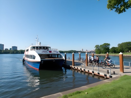
Ferry Connections: The Waterfront Perspective
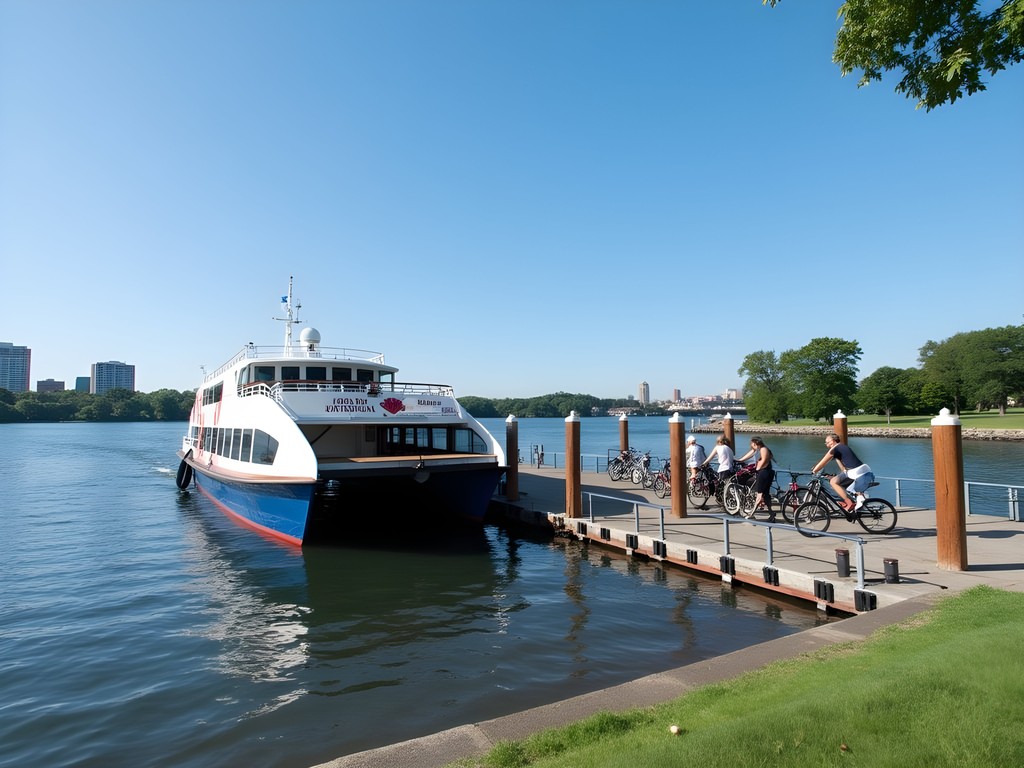
While bikes offer freedom on land, it's the seasonal ferry service that truly unlocks East Providence's connection to the wider Narragansett Bay. The Providence-Newport Ferry (with stops in East Providence during summer weekends) transformed my understanding of the region's geography and history.
The ferry terminal at Bold Point Park serves as the main departure point, with covered waiting areas and bike racks. I arrived early to secure a spot for my folding bike, though the ferry accommodates standard bicycles as well. The $11 one-way fare to Newport feels remarkably reasonable for the experience offered.
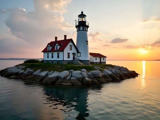
The 60-minute journey provides a water-level view of landmarks like the Crook Point Bascule Bridge and Conimicut Point Lighthouse that simply can't be appreciated from land. I found myself sketching architectural details in my waterproof notebook, inspired by how these structures dialogue with their natural surroundings.
For those sensitive to motion, I'd recommend a travel pillow to make the journey more comfortable, especially on windier days when the bay gets choppy. The pillow's memory foam conforms perfectly to your neck, providing support while you enjoy the scenic journey.
💡 Pro Tips
- Book ferry tickets online to guarantee space for your bicycle
- Arrive 20 minutes early during peak summer season
- Sit on the starboard (right) side when heading to Newport for the best views of East Providence's industrial waterfront

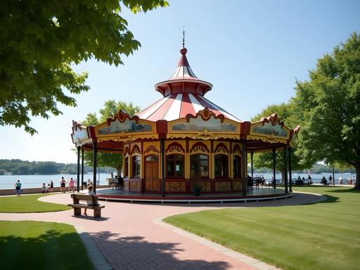
Crescent Park: A Historic Waterfront Sanctuary
No car-free exploration of East Providence would be complete without dedicating time to Crescent Park, home to the historic Looff Carousel. This waterfront green space represents what I find most compelling about American urban design—the preservation of recreational spaces along valuable waterfront property.
I cycled here on my second day, following the East Bay Bike Path to where it intersects with the park. The 1895 carousel building—a National Historic Landmark—stands as a testament to the area's past as a thriving amusement park. The detailed craftsmanship of the hand-carved horses reflects an era when public spaces were designed for both beauty and function.
The park offers expansive lawn areas perfect for spreading out a pocket blanket, which packs down to the size of a smartphone but unfolds to seat 2-4 people comfortably. I spent a peaceful afternoon here watching sailboats navigate the bay while sketching the carousel's architectural details.
What struck me most was how this public space serves multiple communities simultaneously—families enjoying the carousel, fishing enthusiasts along the shore, and cyclists passing through on longer journeys. This multi-use approach to public space design reflects the best principles of accessibility that I strive for in my own design work.

💡 Pro Tips
- Visit the carousel on weekday mornings to avoid lines
- The fishing pier offers excellent sunrise photography opportunities
- Bring cash for the carousel rides ($2 per ride)
Navigating the Urban Core: Buses and Walking Routes
While bikes and ferries form the backbone of car-free travel in East Providence, the RIPTA bus system effectively fills the gaps. Routes 32, 33, and 34 connect the waterfront areas to the more residential northern neighborhoods, operating with surprising frequency (every 20-30 minutes) during weekdays.
I utilized the bus system to reach the evolving Riverside Square district, where former industrial buildings now house studios, galleries, and craft breweries. The architecture here tells the story of Rhode Island's manufacturing past while its current uses point toward a creative future.
For exploring the urban core on foot, I found my trail running shoes provided the perfect balance of comfort and durability on mixed surfaces. Unlike the pristine retail environments I once designed, East Providence's sidewalks and streets have character—sometimes meaning uneven bricks and cobblestones in historic areas.
The most rewarding walking route connects Watchemoket Square to the Heritage Park waterfront via Veterans Memorial Parkway. This tree-lined boulevard was designed in the early 20th century as a scenic drive, but it's equally impressive experienced at walking pace, with its arching trees creating a natural cathedral effect that changes with the seasons.

💡 Pro Tips
- RIPTA buses all have bike racks, but they only accommodate two bikes at a time
- Download the Transit app for real-time bus arrivals
- The Watchemoket Square to Heritage Park walking route offers the best architecture viewing
Final Thoughts
Navigating East Providence without a car revealed layers of this waterfront city that would have remained invisible from behind a windshield. The industrial heritage, architectural details, and natural beauty come alive when experienced at human speed—whether pedaling along the East Bay Bike Path or watching the shoreline unfold from a ferry deck. As someone who has designed spaces for human experience, I found profound satisfaction in how East Providence balances preservation with accessibility, creating authentic connections between people and place.
This approach to car-free travel isn't just environmentally sustainable—it's emotionally sustainable too. The slower pace allowed me to sketch, photograph, and truly absorb the character of East Providence in ways that rushed tourism never permits. For fellow travelers seeking genuine connection with both built and natural environments, I can't recommend this approach highly enough. Pack light, stay flexible, and let the rhythm of pedals and ferry horns guide your exploration of this underrated Rhode Island gem.
✨ Key Takeaways
- The East Bay Bike Path provides the perfect spine for car-free exploration of East Providence's waterfront
- Seasonal ferry service connects East Providence to Newport, offering unique water-level perspectives of the region
- RIPTA buses effectively fill transportation gaps when biking distances are too great
- Historic sites like the Looff Carousel are more meaningfully experienced when approached at a human pace
- Car-free travel reveals architectural and natural details that would be missed when driving
📋 Practical Information
Best Time to Visit
Late May through September (ferry service operates seasonally)
Budget Estimate
$200-350 for a weekend (including accommodation, transportation, and meals)
Recommended Duration
2-3 days
Difficulty Level
Moderate


Comments
backpackguide
Just got back from RI. East Providence was way better than expected! That carousel is amazing.
Sage Dixon
Brandon, this brought back memories! I biked through East Providence last summer during my Boston-to-NYC coastal journey. For anyone planning this trip, don't miss the hidden gem of Sabin Point Park - it's a perfect spot to watch the sunset over Providence's skyline. Also, there's a little seafood shack near the Bold Point ferry landing that serves the most incredible clam cakes I've had in New England. One tip: the winds can pick up in the afternoon along the bay, so morning rides tend to be more pleasant. And if you're staying overnight, the historic homes near Watchemoket Square have some charming Airbnbs that put you right by the bike path.
wavechamp
Great post! Is it possible to do this trip with kids? My daughter is 8 and can ride but not super long distances.
coffeeace756
Not the author, but I've done the East Bay path with my 7-year-old! It's mostly flat and you can do just segments. The section near Crescent Park is perfect for kids with plenty of places to stop.
Jean Wells
Having explored over 30 car-free cities globally, I found East Providence offers a unique proposition. The integration of the bike path with waterfront access creates an experience that rivals many European cities. I particularly appreciated how the industrial history is preserved alongside natural spaces. One note: the section near Watchemoket Square can be confusing for first-timers - I'd recommend downloading offline maps before setting out. The ferry timing worked perfectly with my itinerary, though I'd caution that weekend schedules can be limited during shoulder season. Excellent documentation of an underappreciated destination.
wavechamp
Jean, any recommendations for accommodations that are bike-friendly in the area?
Jean Wells
I stayed at a small B&B near Watchemoket Square that had secure bike storage. Several hotels in downtown Providence also offer bike storage and are just a short ride from East Providence via the Washington Bridge crossing.
coffeemood
Brandon, you nailed it with this guide! We followed your advice last week and rented bikes from that shop near the East Providence Yacht Club. Spent the whole day cruising the East Bay path and then caught the sunset ferry back. Crescent Park was magical - that carousel is a trip back in time! The best part was stopping at those little waterfront cafes you mentioned. My foldable water bottle came in super handy since it was pretty warm that day.
journeywanderer4755
This looks amazing! I'm planning to visit in September without a car. How reliable is the ferry service? Is there a schedule posted somewhere?
backpackguide
The Providence-Newport ferry runs pretty regularly through September. Check out seastreak.com for schedules!
journeywanderer4755
Thanks for the tip! I'll check it out.
coffeeace756
Just did the East Bay Bike Path last weekend! Such an underrated gem in Rhode Island. The views of the bay are incredible.
Sage Dixon
Right?! I feel like East Providence doesn't get enough credit compared to Newport or Providence proper. The bike path is one of my favorites on the east coast!
coffeeace756
Totally agree! Way less crowded too, which is a huge plus in my book.
freemate
Just did the ferry ride yesterday - those sunset views of the Providence skyline are unreal!
RhodyLocal
Great post! Just want to add that the ferry schedule changes seasonally. If you're visiting between November and April, check the winter schedule as they run fewer trips. Also, Crescent Park has amazing events in the summer - worth planning around!
luckywalker
Thanks for the heads up on the ferry schedule! Would you say spring or fall is better for visiting?
RhodyLocal
Fall is magical - the bike path with all the foliage is unbeatable! But spring has fewer tourists. Can't really go wrong with either!
hikingway
Any recommendations for where to stay in East Providence that's bike-friendly and close to the path? Planning a weekend trip in October.
Jean Wells
I stayed at a B&B near Watchemoket Square that was excellent - about a 5-minute ride to the bike path. Several hotels along Waterfront Drive also offer bike storage and are practically on the path.
Venture X
Premium card with 2X miles, $300 travel credit, Priority Pass