


Disclosure: This article contains affiliate links. We may earn a commission from purchases at no extra cost to you, which helps our travel content.
The landscape unfolds like a case file waiting to be examined—stratified rock formations chronicling millions of years, abandoned mining towns holding secrets of frontier ambition, and vast expanses where the horizon seems infinitely distant. As someone who spent 15 years decoding art theft patterns, I find Wyoming's geological canvas offers similar intellectual satisfaction, albeit on a grander scale. Rock Springs, with its rugged terrain and rich history, presents the perfect basecamp for a detective of landscapes rather than crime scenes.

Preparing Your Investigative Vehicle
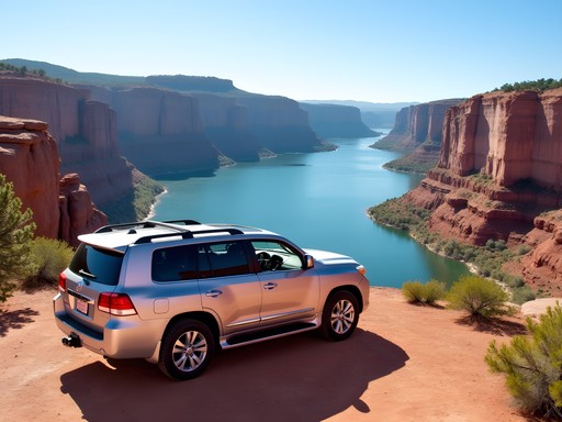
Before embarking on any Wyoming expedition, your vehicle requires meticulous preparation—not unlike assembling equipment for a stakeout. Rock Springs' surrounding terrain demands respect and forethought.
First, consider your vehicle choice carefully. While summer roads are generally well-maintained, many worthwhile destinations require high clearance. I opted for a mid-size SUV with 4WD capabilities, which proved invaluable when exploring the more remote sections of Flaming Gorge and the Adobe Town badlands. My Garmin GPS earned its keep repeatedly, particularly when cellular service disappeared in the high desert landscape.
Vehicle inspection is non-negotiable. The distances between service stations can be substantial, and summer temperatures regularly exceed 90°F (32°C). Have your cooling system, brakes, and tires thoroughly checked before departure. I carry a comprehensive roadside emergency kit that includes jumper cables, a compact air compressor, and basic tools—items that provide peace of mind when the nearest assistance might be hours away.

💡 Pro Tips
- Rent vehicles in Salt Lake City or Denver for better selection and rates than in Rock Springs itself
- Always keep your fuel tank at least half full—gas stations are sparse in many directions
- Download offline maps before departure—cellular connectivity is unreliable outside town centers
The Geological Cold Case: Flaming Gorge and Green River Formation
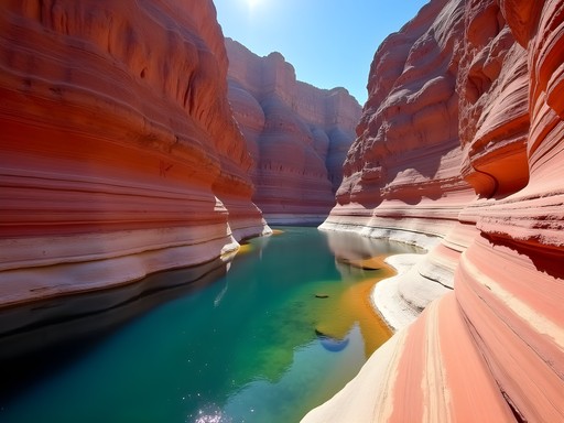
The Flaming Gorge National Recreation Area presents what I'd call a 'geological cold case'—evidence scattered across millions of years, waiting for the observant traveler to connect the dots. The 91-mile drive from Rock Springs to the reservoir offers a masterclass in reading landscapes.
Begin your investigation at the Flaming Gorge Dam Visitor Center, where interpretive displays provide crucial context for understanding the area's formation. The real revelations, however, come from taking the Sheep Creek Geological Loop, a 13-mile scenic byway that showcases nearly 2 billion years of Earth's history through tilted, folded, and fractured rock layers.
For those with archaeological interests similar to my partner's, the Green River Formation demands attention. This series of sedimentary deposits contains some of the world's best-preserved fossils. The Fossil Butte National Monument, though a 2-hour drive northwest, offers extraordinary specimens from an ancient lake ecosystem. I spent hours examining the intricacies of perfectly preserved fish, plants, and insects—each a snapshot of life from 52 million years ago.
Packing a quality binoculars enhances both wildlife spotting and distant geological feature examination. The clarity allowed me to study rock stratification patterns from viewpoints that would otherwise require technical climbing skills.

💡 Pro Tips
- Visit Firehole Canyon for swimming in summer—the water is surprisingly comfortable despite the reservoir's depth
- Early mornings offer the best light for photographing the red rock formations
- The Sheep Creek Geological Loop requires about 2 hours with stops—bring water and sun protection
Tracing Historical Evidence: The Oregon Trail and Mining Heritage
My investigative instincts are particularly engaged when examining historical sites—places where human narratives intertwine with landscape. Rock Springs sits at the crossroads of several significant Western migration routes, offering rich opportunities to trace America's westward expansion.
Begin at the Sweetwater County Historical Museum in Green River (just 15 minutes from Rock Springs), where period artifacts and photographs establish critical context. The museum's collection of Chinese artifacts tells the often-overlooked story of immigrant railroad workers who established one of Wyoming's earliest Chinatowns in Rock Springs.
For field investigation, drive north to South Pass City State Historic Site, a remarkably preserved gold mining town that feels suspended in time. Unlike many over-commercialized Western attractions, South Pass City maintains authentic structures and mining equipment. The site's isolation—nearly 60 miles from Rock Springs on Highway 28—has preserved its integrity.
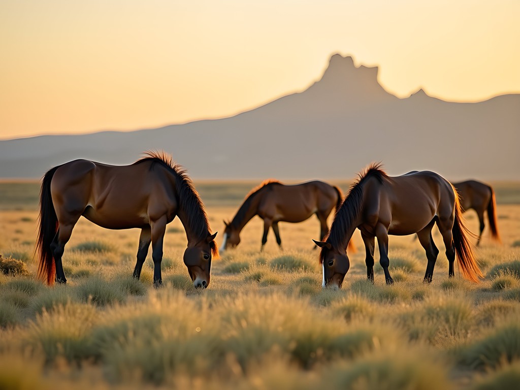
More accessible is the Pilot Butte Wild Horse Scenic Loop, a 24-mile gravel road where descendants of mining horses still roam free. I recommend using a telephoto lens for photographing these magnificent creatures without disturbing them. My morning expedition yielded exceptional photographs when the horses were most active and the light most dramatic.
To properly document these historical sites, I rely on my field notebook. Its water-resistant pages proved invaluable during an unexpected summer shower at Boar's Tusk, an ancient volcanic remnant sacred to Native American tribes.
💡 Pro Tips
- Visit South Pass City early in the day to avoid afternoon thunderstorms common in summer
- The Pilot Butte Wild Horse Loop is best driven slowly—plan for at least 2-3 hours to properly observe
- Bring cash for the donation-based museums in smaller communities like Superior and Granger

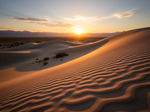
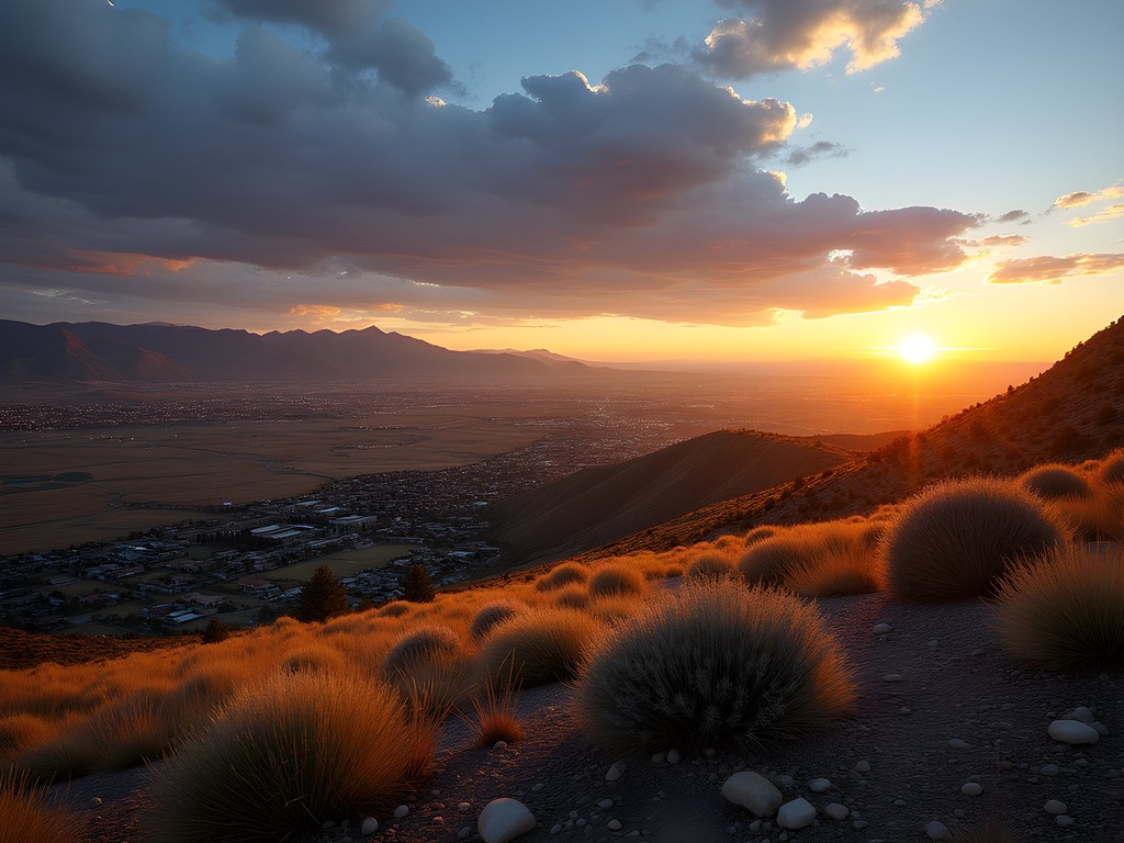
The Desolate Beauty: Adobe Town and Killpecker Sand Dunes
Some investigations require venturing beyond established pathways. The terrain surrounding Rock Springs offers two remarkable opportunities for such exploration: Adobe Town and the Killpecker Sand Dunes.
Adobe Town presents a landscape so otherworldly it resembles a distant planet rather than Wyoming. Located approximately 25 miles southeast of Rock Springs, this badlands area features eroded clay formations creating natural amphitheaters, arches, and hoodoos. The area demands four-wheel drive, substantial ground clearance, and serious navigation skills—I wouldn't attempt it without both a physical map and GPS coordinates, as roads are unmarked and cellular service nonexistent. My handheld GPS proved essential here, particularly when afternoon thunderclouds threatened and I needed to plot the most efficient route back to established roads.
More accessible but equally dramatic are the Killpecker Sand Dunes, one of North America's largest active dune fields. The public access area lies about 10 miles north of Rock Springs off Highway 191. The contrast between verdant sagebrush plains and towering sand mountains creates a photographer's paradise, particularly in early morning when the low-angle light accentuates the dunes' sculptural qualities.
For those seeking adventure, the Killpecker Dunes offer designated ATV areas, though I prefer exploring on foot, following the rippling patterns created by wind. Sturdy hiking boots are essential—summer sand temperatures regularly exceed 120°F (49°C). I recommend wearing desert hiking gaiters to prevent sand infiltration, a lesson I learned rather painfully on my first dune expedition.

💡 Pro Tips
- Adobe Town requires serious 4WD vehicles and navigation skills—don't attempt it solo or without proper preparation
- Visit Killpecker Dunes at sunrise for the most dramatic lighting and cooler temperatures
- Bring significantly more water than you think necessary—the dry air and exposed terrain accelerate dehydration
Basecamp Operations: Lodging and Dining in Rock Springs
After long days investigating Wyoming's geological and historical evidence, establishing a comfortable basecamp becomes essential. Rock Springs, while not known for luxury accommodations, offers several practical options for the discerning traveler.
I selected the Hampton Inn Rock Springs as my primary lodging—its reliable comfort, breakfast offerings, and central location made it ideal for daily excursions in different directions. For those seeking more character, the historic Outlaw Inn provides a glimpse into Rock Springs' more colorful past, though the amenities are less consistent.
For longer stays or groups, consider booking a vacation rental in the White Mountain area north of town. These properties often provide kitchen facilities and more space—valuable assets when preparing for early departures or processing the day's photographic evidence.
Regarding sustenance, Rock Springs offers surprisingly diverse options for a town its size. Broadway Burger Station serves exceptional bison burgers in a converted 1950s gas station—their house-made sauces merit particular attention. For more sophisticated fare, Bitter Creek Brewing offers craft beers and elevated pub cuisine; their trout almondine showcases local fish with European preparation techniques.
My investigative work always benefits from proper caffeination. Mug Shots Coffeehouse downtown provides excellent espresso and local insights—the baristas proved invaluable sources of information about road conditions and lesser-known viewpoints. Their recommendation led me to Firehole Canyon's hidden petroglyph panel, which wouldn't appear in standard guidebooks.
For field provisions, I recommend the insulated water bottle to keep water cool despite scorching temperatures. Similarly, a quality cooler allows you to pack substantial lunch provisions, critical when exploring areas without services.
💡 Pro Tips
- Book accommodations well in advance during summer months—limited options fill quickly
- Ask local servers and baristas about road conditions—they often have more current information than official sources
- Stock up on provisions at Smith's Food and Drug—their deli provides excellent portable lunch options
Final Thoughts
Rock Springs may appear unremarkable at first glance—a frontier outpost primarily serving as a refueling stop for interstate travelers. But as any good detective knows, the most revealing evidence often hides in plain sight. This corner of Wyoming rewards the investigative traveler with geological formations that read like ancient case files, historical sites that whisper stories of ambition and struggle, and landscapes so diverse they challenge conventional categorization.
What distinguishes this region is precisely its unpolished authenticity. Unlike the national parks with their choreographed experiences and crowds, the Rock Springs region demands self-sufficiency and rewards curiosity. You won't find tour buses or gift shops at Adobe Town's clay labyrinths or along the unmarked trails where wild horses graze at dawn.
As I pack my field notes and prepare to return to Ireland, I'm struck by how this landscape has revealed itself layer by layer—not unlike the stratified rocks of Flaming Gorge. For those willing to venture beyond the obvious, to examine the evidence presented by both nature and human history, Rock Springs offers an investigation worth pursuing. The case remains perpetually open, with new discoveries awaiting each return visit.
✨ Key Takeaways
- Rock Springs provides an ideal basecamp for exploring diverse Wyoming landscapes from sand dunes to red rock canyons
- Vehicle preparation is essential—many worthwhile destinations require high clearance and navigation skills
- The region rewards self-directed exploration rather than guided experiences
📋 Practical Information
Best Time to Visit
June through September
Budget Estimate
$75-150/day excluding vehicle rental
Recommended Duration
5-7 days
Difficulty Level
Moderate


Comments
exploreking
Those photos of the stratified rock formations are incredible! Nature's art gallery.
coffeelife
How many days would you recommend for exploring everything mentioned in this guide? Planning a road trip for next summer!
wanderadventurer
Not the author but we spent 4 days and it felt rushed. I'd say minimum 5 days, ideally a week if you want to properly explore the Flaming Gorge area and do some hiking.
Francesca Lopez
I love how you framed Rock Springs as a detective story, Kimberly! The mining heritage there is fascinating. When I visited last year, I stumbled upon a local historian at the Rock Springs Historical Museum who shared incredible stories about the Chinese massacre of 1885 - a dark chapter in the town's history that provides important context to the development of labor relations in the American West. For anyone interested in this aspect, I recommend setting aside at least 2 hours for the museum and asking specifically about these stories - they aren't prominently featured but are crucial to understanding the area's complex past.
Kimberly Morales
Thanks for highlighting this, Francesca. You're absolutely right - understanding the complete history, including its darkest chapters, gives so much more depth to the experience. I'll definitely include this perspective if I update the guide.
wanderadventurer
Just got back from Rock Springs last month! Your section on Adobe Town was spot on - it feels like being on another planet. We spent a full day hiking and photographing the formations. Pro tip for anyone going: the lighting for photography is absolutely magical during golden hour. Also, we encountered some wild horses near Killpecker Sand Dunes which wasn't mentioned in the post but was definitely a highlight!
exploreking
Wild horses?! That sounds amazing. How close were you able to get to them?
wanderadventurer
We kept a respectful distance (used a zoom lens for photos). They're wild animals after all. But it was incredible just watching them roam across the landscape!
Taylor Moreau
Excellent guide, Kimberly. I recently had to make an unexpected detour through Rock Springs during a business trip to Salt Lake City, and I was pleasantly surprised. The geological formations are truly spectacular - almost otherworldly. I particularly enjoyed the Flaming Gorge area which offered a welcome respite from conference calls. One suggestion for business travelers: cell reception can be spotty in the more remote areas, so download your important files beforehand and consider satellite communicator if venturing far from the main roads.
coffeelife
Was the road to Flaming Gorge okay for a standard rental car? Planning a trip but not sure if I need 4WD.
Taylor Moreau
The main roads to Flaming Gorge are well-maintained and fine for any vehicle. I was in a standard sedan rental. Only if you plan to explore the more remote trails would you need 4WD.
greenone
Never thought Wyoming would be on my bucket list but those sand dunes look incredible! Adding this to my travel plans.
Sophia Gomez
This post hits different! I've passed through Rock Springs probably a dozen times for work conferences in Salt Lake City, and I always thought of it as just... nothing. But you've completely reframed it. Last month I finally took a detour to Flaming Gorge based on a colleague's recommendation, and wow. The red rocks against that turquoise water? Unreal. Next time I'm definitely checking out Adobe Town. The way you weave the detective/investigation metaphor throughout really works - it makes you want to uncover these 'secrets' yourself.
travelseeker
Love the photos! Adding this to my bucket list
Jean Wells
Kimberly, your investigative approach to travel writing is refreshing. I've driven through Wyoming numerous times but never considered Rock Springs as a destination unto itself. The geological stratification you describe reminds me of similar formations I've studied in the Gobi Desert. One question: how accessible are the Oregon Trail remnants? I'm particularly interested in the less-visited historical sites that require more effort to reach. The juxtaposition of natural history and human history in this region deserves more attention than it receives.
Kimberly Morales
Jean, thank you! The Oregon Trail markers around South Pass are fairly accessible, but the real gems are the wagon ruts you can still see in remote areas. Some require hiking a few miles off-road. I'd recommend connecting with the local historical society - they have maps to lesser-known sites.
happyclimber
what's the best season to visit? trying to avoid extreme temps
Venture X
Premium card with 2X miles, $300 travel credit, Priority Pass