


Disclosure: This article contains affiliate links. We may earn a commission from purchases at no extra cost to you, which helps our travel content.
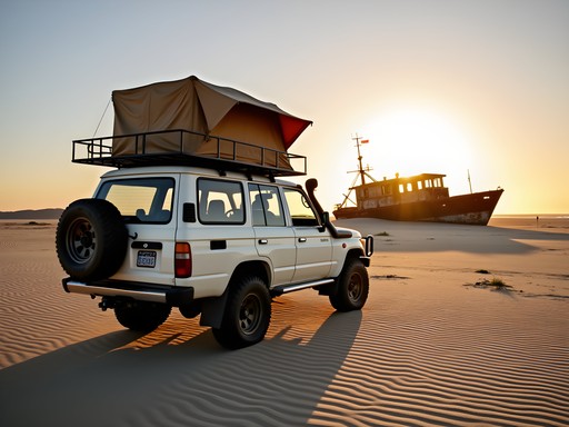
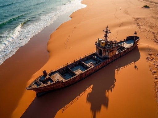
The Land Cruiser's tires crunched over the salt-crusted sand as I gazed at the skeletal remains of shipwrecks dotting Namibia's haunting coastline. This marked the beginning of my most ambitious African adventure yet—a 3,000+ kilometer overland journey from the desolate beauty of the Skeleton Coast to the vibrant shores of Lake Victoria. After five previous trips to the continent, I was finally tackling my dream route through Namibia, Zambia, and Tanzania, connecting some of Africa's most dramatic landscapes and diverse cultures by road. Grab your maps and join me on this epic month-long expedition that will challenge your driving skills, expand your cultural horizons, and deliver the adventure of a lifetime.

Preparing for Africa's Ultimate Road Trip
When my friend Lucia (a fellow legal assistant with an equally intense wanderlust) agreed to join this expedition, we spent three months meticulously planning our route. This isn't your typical holiday—crossing three countries by road requires serious preparation.
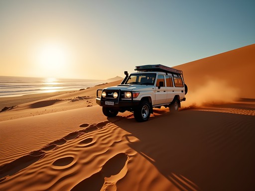
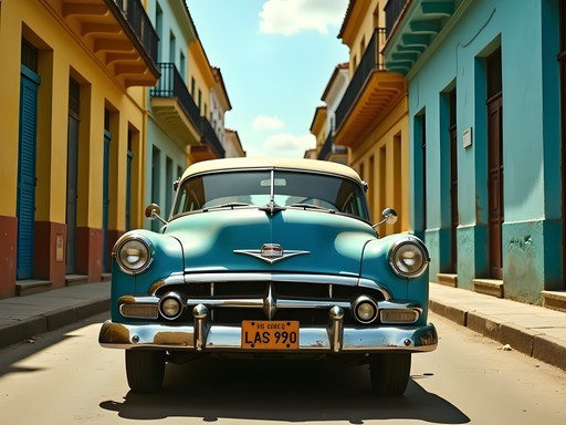
First, vehicle selection. After researching extensively, we opted for a Toyota Land Cruiser rental with roof tents, extra fuel tanks, and comprehensive insurance. While not cheap at roughly $120/day, this beast handled everything from deep sand to rocky mountain passes without complaint.
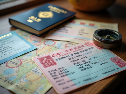
Documentation proved equally crucial. Beyond passports with at least 8 empty pages, we needed international driving permits, vehicle insurance covering all countries, carnet de passage (vehicle passport), and yellow fever certificates. Border crossings in Africa require patience and preparation—I kept all documents organized in a waterproof travel document organizer that proved invaluable during unexpected downpours.
For navigation, I downloaded offline maps on both Garmin inReach Explorer+ (which also served as our emergency satellite communicator) and Maps.me. Cell service exists mainly near towns, so don't rely solely on your phone.

💡 Pro Tips
- Book your 4x4 at least 3 months in advance during high season (June-October)
- Carry multiple copies of all vehicle documentation—officials often keep copies at border crossings
- Learn basic vehicle maintenance including changing tires and checking fluids before departure
Namibia's Skeleton Coast to Etosha: Desolation to Abundance
The journey's first leg took us through landscapes so contrasting they seemed from different planets. The Skeleton Coast—aptly named for its shipwrecks and whale bones—is a 500km stretch where the Namib Desert meets the Atlantic. Morning fog shrouded the beach as we drove northward from Swakopmund, creating an eerie backdrop for the rusted remains of vessels claimed by these treacherous waters.
After two days navigating this coastal wilderness (permits required and arranged in advance), we turned inland toward Damaraland. The transformation was gradual but stunning—ochre desert giving way to rocky outcrops where desert-adapted elephants roam. We spent a night wild camping near Twyfelfontein, falling asleep to distant lion roars after exploring ancient rock engravings by day.
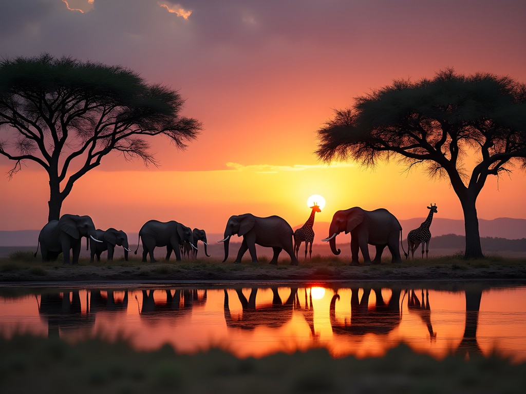
By day five, we reached Etosha National Park, where the landscape shifted dramatically again to vast salt pans and savanna teeming with wildlife. Self-driving through Etosha offers unparalleled freedom—we spent sunrise to sunset tracking herds of elephants, zebras, and witnessing three lionesses on a successful hunt. The Nikon Monarch 7 binoculars I brought proved invaluable for spotting distant wildlife while keeping a safe distance.
Camping inside Etosha at Okaukuejo provided the trip's most magical moment: watching rhinos, elephants and giraffes visit the floodlit waterhole just steps from our campsite as stars blanketed the African sky.
💡 Pro Tips
- Get your Skeleton Coast permit at least 2 months in advance—they limit daily entries
- Fill all fuel tanks before entering remote areas; stations can be 400+ km apart
- In Etosha, early morning (6-9am) and late afternoon (4-7pm) offer the best wildlife viewing
Crossing Borders: Navigating Zambia's Wilderness
Leaving Namibia, we faced our first major border crossing at Katima Mulilo. Despite arriving early, the process took nearly three hours—a lesson in African patience. Tip: bring small US dollar bills for various 'fees' that mysteriously appear during these crossings.
Zambia's roads marked a dramatic shift from Namibia's well-maintained network. Potholes became our constant companions as we navigated toward Livingstone, home to the magnificent Victoria Falls. Here, we splurged on two nights at a proper lodge to shower, recharge devices, and reorganize gear after a week of camping. The thundering 'Smoke that Thunders' lived up to its reputation—we spent a full day exploring viewpoints and getting drenched in the spray.
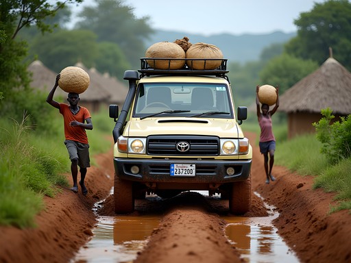
From Livingstone, we ventured northeast through Zambia's interior, where tourism infrastructure thins considerably. Villages replaced towns, and our progress slowed to sometimes just 200km daily. This region demanded our most crucial piece of equipment: a water purification system that converted river and borehole water into safe drinking supply.
The reward for these challenging roads? Pristine wilderness and authentic cultural exchanges. In a small village near Kasanka National Park, we were invited to a local gathering where I joined women pounding cassava—my pathetic attempts causing uproarious laughter that bridged any language barriers.
Kasanka itself offered a magical wildlife experience without Etosha's crowds. Though smaller, its wetlands host incredible birdlife and the world's largest fruit bat migration (October-December). Our campsite beside the Luwombwa River became my favorite overnight stop—hippos serenaded us with their distinctive honking laughs throughout the night.

💡 Pro Tips
- Budget extra time for border crossings—they rarely take less than 2 hours
- Carry printed copies of accommodation bookings; immigration often wants to see where you're staying
- Download iOverlander app for up-to-date road conditions and border crossing reports

Tanzania's Western Corridor: The Road to Lake Victoria
The Tanzania border crossing near Tunduma tested our patience further—six hours of shuffling between offices, filling forms, and negotiating various 'processing fees.' Pro tip: download and pre-fill Tanzania's visa application to save precious time.
Once through, Tanzania's southern highlands delivered breathtaking scenery and a welcome climate change. Cooler temperatures and verdant mountains replaced Zambia's heat as we wound our way toward Lake Victoria. We detoured to Ruaha National Park, where the compact safari camera I'd been testing captured incredible close-ups of leopards and elephants against dramatic kopje landscapes.
As we pushed northwest, roads deteriorated again. What Google Maps optimistically suggested would be a six-hour drive stretched to eleven bone-jarring hours. The compensation? Passing through regions few tourists ever see, where children ran alongside our vehicle in excitement and every stop attracted friendly crowds curious about our journey.
After three challenging weeks on the road, the first glimpse of Lake Victoria's vast blue expanse felt like a mirage. We'd traversed nearly the width of the African continent, from the Atlantic-kissed deserts of Namibia to this immense inland sea.
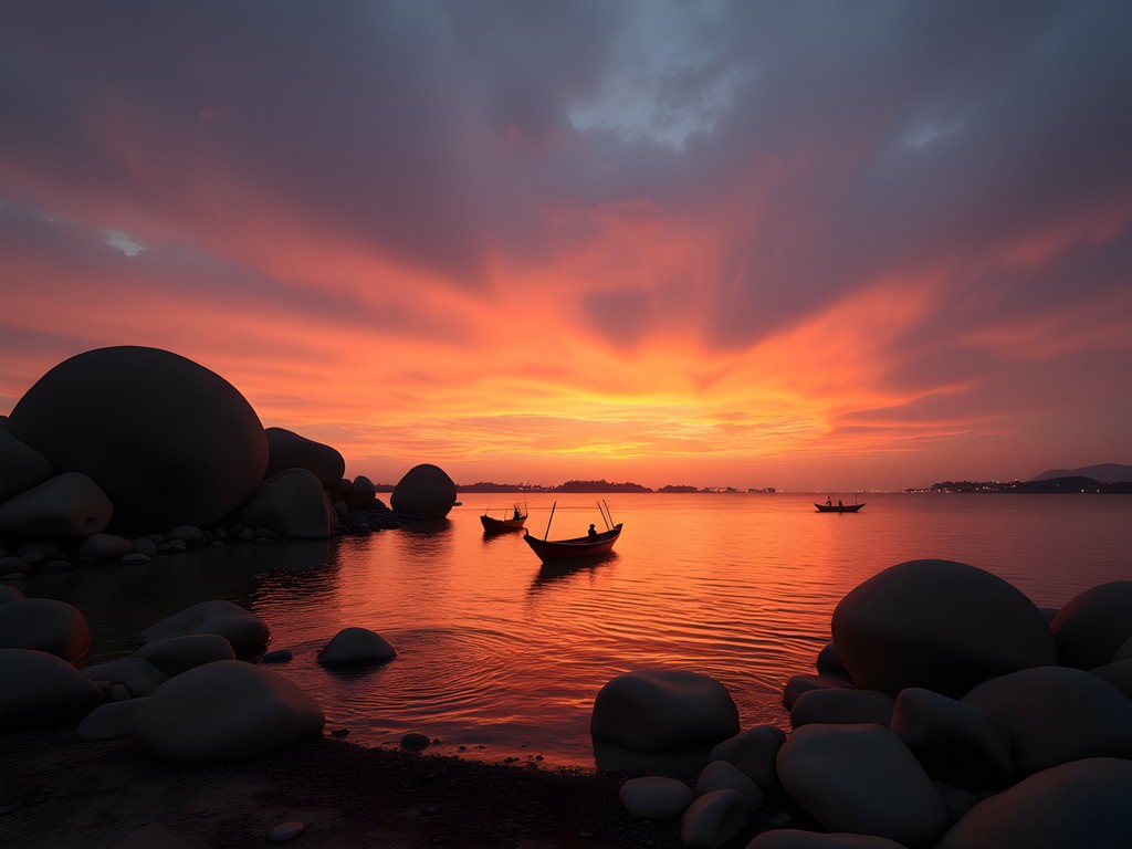
Our final destination, Mwanza, revealed a bustling lakeside city where we celebrated with fresh tilapia at a local restaurant overlooking the water. The distinctive rock formations jutting from the lake (inspiration for Pride Rock in The Lion King, according to locals) provided a perfect backdrop for reflection on our epic journey.
The final night, we splurged on a lakeside hotel in Mwanza, where I soaked my travel-weary body in a proper bath for the first time in weeks. From my balcony, fishing boats dotted the sunset-painted waters—a peaceful conclusion to our 3,000-kilometer adventure across three of Africa's most captivating countries.
💡 Pro Tips
- Tanzania's roads are notoriously rough—add 50% to Google Maps time estimates
- Carry a spare vehicle air filter; Tanzania's dusty roads clog them quickly
- Download Tanzanian shillings currency converter app—many remote areas don't accept cards or dollars
Practical Logistics: Fuel, Accommodation & Safety
Successfully completing this route requires careful logistical planning. Fuel management topped our daily priorities—I maintained a detailed log of kilometers traveled and fuel consumed, never letting our tank drop below half-full. The longest stretch without fuel was 380km in northern Namibia, though our auxiliary tank provided peace of mind.
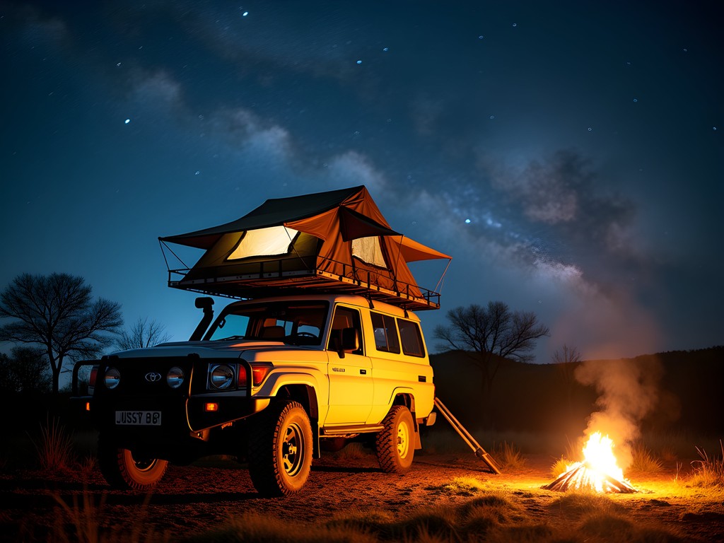
Accommodation varied wildly. We camped 22 of our 30 nights, alternating between established campgrounds with facilities and wild camping in remote areas (legal in many parts of these countries with proper permits). Our rooftop tent proved worth every penny—quick to set up and keeping us safely above ground in wildlife-rich areas. For the remaining nights, we chose mid-range lodges strategically placed for proper showers and rest.
Safety concerns often dominate conversations about African travel, but our experience was overwhelmingly positive. Common-sense precautions served us well: we never drove after dark, kept valuables hidden, and always informed someone of our route. The satellite communicator provided crucial emergency backup in areas without cell service.
Food planning required creativity. We carried a dual-zone portable refrigerator powered by the vehicle that kept essentials fresh. Local markets provided vegetables, fruits and bread, while we relied on longer-lasting staples (rice, pasta, canned goods) for remote stretches. Some of our best meals were simple pasta dishes cooked on our camp stove as elephants trumpeted in the distance.
💡 Pro Tips
- Never pass a fuel station without topping up, regardless of your current level
- Invest in good-quality camping gear—it's your home for a month in challenging conditions
- Learn key phrases in local languages—'hello,' 'thank you,' and 'beautiful country' open many doors
Final Thoughts
As our flight lifted off from Mwanza's small airport, I pressed my face against the window for a final glimpse of Lake Victoria shimmering below. This journey across southern Africa's vast wilderness had been more than just an adventure—it was a masterclass in patience, adaptability, and cultural connection. From the haunting shipwrecks of the Skeleton Coast to the vibrant fishing communities of Lake Victoria, we'd traversed environments so diverse they defied imagination.
This route isn't for everyone. It demands mechanical knowledge, comfort with uncertainty, and the ability to problem-solve far from help. Yet for experienced travelers willing to embrace the challenges, the rewards are immeasurable: nights under star-filled skies untouched by light pollution, conversations with villagers rarely visited by outsiders, and the profound sense of accomplishment that comes from navigating one of Earth's most magnificent continents on your own terms.
As I plan my next African adventure (the Western Africa coastal route is calling), I'm already nostalgic for those long, dusty days behind the wheel, where the journey itself—not just the destinations—created the most enduring memories. If you're ready for the ultimate self-drive adventure, this Skeleton Coast to Lake Victoria route offers a perfect blend of challenge, beauty, and transformation. Buon viaggio, fellow adventurers!
✨ Key Takeaways
- This 3,000km route requires extensive preparation but delivers unparalleled access to authentic Africa
- A reliable 4x4 vehicle with camping equipment is essential for the challenging terrain and remote locations
- Border crossings demand patience, preparation and extra documentation
- The dramatic landscape transitions—from desert to savanna to highlands to lakeshore—make this one of Africa's most diverse road trips
📋 Practical Information
Best Time to Visit
May-October (dry season)
Budget Estimate
$5,000-7,000 per person for 30 days (including vehicle rental)
Recommended Duration
Minimum 3-4 weeks
Difficulty Level
Advanced - Requires 4x4 Experience And Self-Sufficiency


Comments
Stephanie Romano
Skylar, this brought back so many memories! We did a similar route in 2023 but with our two kids in tow - definitely a different experience than solo travel. The Skeleton Coast was absolutely haunting, wasn't it? We stayed at Terrace Bay and my 8-year-old was obsessed with the seal colony. Quick question - how were the road conditions through western Zambia? We had to turn back at one point because the rainy season had washed out a bridge. Also curious what you did about vehicle insurance crossing all those borders? That was our biggest headache honestly.
vacationgal3415
Would love to know about the insurance too! Planning something similar for next year
Stephanie Romano
If Skylar doesn't respond - we ended up getting a Comesa Yellow Card at the Namibia-Zambia border. Covered us for most countries but still had to get separate coverage for Tanzania. Bit of a hassle but worth it!
vacationgal3415
Wow this is incredible!! Adding to my bucket list
happybackpacker
LOVE THIS!! Lake Victoria at sunset is something else. The whole journey sounds incredible. Definitely inspired to finally do an overland trip - been talking about it for years!
Hunter Thompson
Absolutely brilliant write-up! I've been planning a similar route for ages and this is super motivating. Quick question - how did you handle the border crossings? I've heard mixed things about the Zambia/Tanzania crossing at Tunduma. Also, did you need a carnet for the vehicle? I've been trying to sort out all the paperwork and it's doing my head in honestly. Your bit about Etosha was spot on too - the contrast between the Skeleton Coast and Etosha is just mad, isn't it? Went from total desolation to animals everywhere within a day's drive.
Skylar Bryant
The carnet saved us so much hassle! Tunduma was actually fine, just took a few hours. Bring patience and snacks. The paperwork is annoying upfront but worth it. DM me if you want specific docs info!
happybackpacker
Tunduma can be chaos but if you go early morning it's way better. We crossed at like 7am and breezed through
wavebackpacker
Did the Zambia section last year on public transport and it was wild. The roads can be rough but the people are so friendly. Your photos of the western corridor in Tanzania are stunning btw!
Casey Andersson
The Skeleton Coast is genuinely one of the most otherworldly places I've ever been. We did a fly-in safari there last year and seeing those shipwrecks from the air was haunting. Your overland route sounds incredible though - I imagine experiencing it at ground level over weeks gives you such a different perspective than our quick 3-day luxury trip. Did you camp most nights or mix it up with lodges? The logistics of an overland trip like this have always intimidated me but your post makes it seem totally achievable.
Skylar Bryant
We camped probably 70% of the time but treated ourselves to lodges every few days for proper showers and laundry! The fly-in safari sounds amazing too - different experiences for sure.
skylegend
How long did the whole journey take? And did you ship your own vehicle or rent one there?
Skylar Bryant
Took us 6 weeks total! We rented a Land Cruiser in Windhoek - way easier than shipping. There are some great overland rental companies that specialize in this kind of trip.
skylegend
Thanks! That's actually more doable than I thought
starchamp
This looks absolutely epic! Adding to my bucket list
Megan Martin
Skylar, this comprehensive analysis of the Skeleton Coast to Lake Victoria route provides exceptional value for serious Africa travelers. Having completed the northern portion of this journey last quarter, I can verify the accuracy of your border crossing documentation - particularly the often overlooked detail about vehicle insurance requirements changing at each border. One professional addition: the conservation fees at some of the smaller Tanzanian reserves have increased by approximately 15% since your journey, so readers should budget accordingly. The section on satellite communication options in remote areas was particularly valuable - maintaining connectivity is essential both for safety and for those of us who need to manage business communications while traveling. Excellent contribution to the overland literature.
nomadvibes
Those shipwreck photos are haunting! Love the moody atmosphere you captured.
Venture X
Premium card with 2X miles, $300 travel credit, Priority Pass