


Disclosure: This article contains affiliate links. We may earn a commission from purchases at no extra cost to you, which helps our travel content.
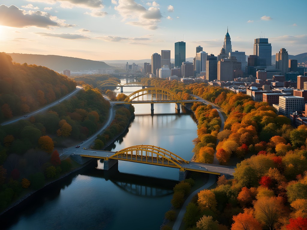
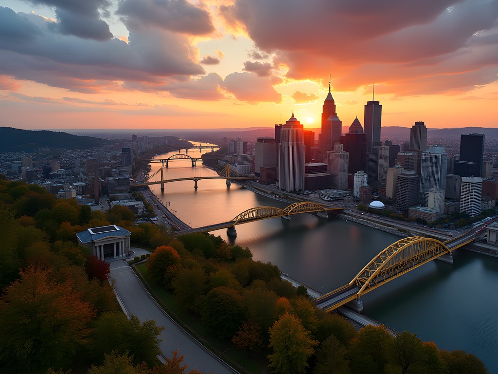
Standing at the confluence of three rivers, Pittsburgh unfolds like an urban forest—steel and glass structures rising alongside verdant hillsides, connected by a complex network of bridges spanning blue waterways. As someone who's spent years studying the delicate dance between built environments and natural systems, I found Pittsburgh to be one of America's most fascinating case studies in urban-nature coexistence. This former industrial powerhouse has transformed itself into a living laboratory of ecological resilience and urban reinvention that rewards the curious explorer.

The Urban Forest: Pittsburgh's Unique Topography
Pittsburgh defies the conventional urban grid with a topography that would make most city planners surrender. Built across steep hills, deep valleys, and three converging rivers (the Allegheny, Monongahela, and Ohio), the city evolved not according to an orderly plan but in response to the demands of its landscape.
What fascinates me as an environmental scientist is how the city's unusual geography created isolated pockets of development that evolved into distinct ecological and cultural microclimates. With over 40% tree canopy coverage—significantly higher than most American cities—Pittsburgh exists as a true urban forest.
During my week exploring the city, I relied heavily on my topographic map to navigate the dramatic elevation changes. Even with digital maps available, having a physical representation of the city's contours helped me understand neighborhood relationships and plan efficient routes that wouldn't leave me breathlessly scaling unexpected hills.
The city's famous inclines—essentially funiculars that climb the steepest slopes—aren't just tourist attractions but functional pieces of infrastructure that have shaped neighborhood development patterns for over a century. These mechanical ecosystems represent a brilliant adaptation to environmental constraints.
💡 Pro Tips
- Pittsburgh's hills can be deceptively steep - wear proper footwear with good traction
- The free InclineNow app provides real-time status updates on the Duquesne and Monongahela Inclines
- For the best views of the urban forest canopy, visit in late October when fall colors peak
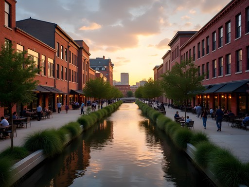
Bridge Ecology: Spanning Rivers and Connecting Communities
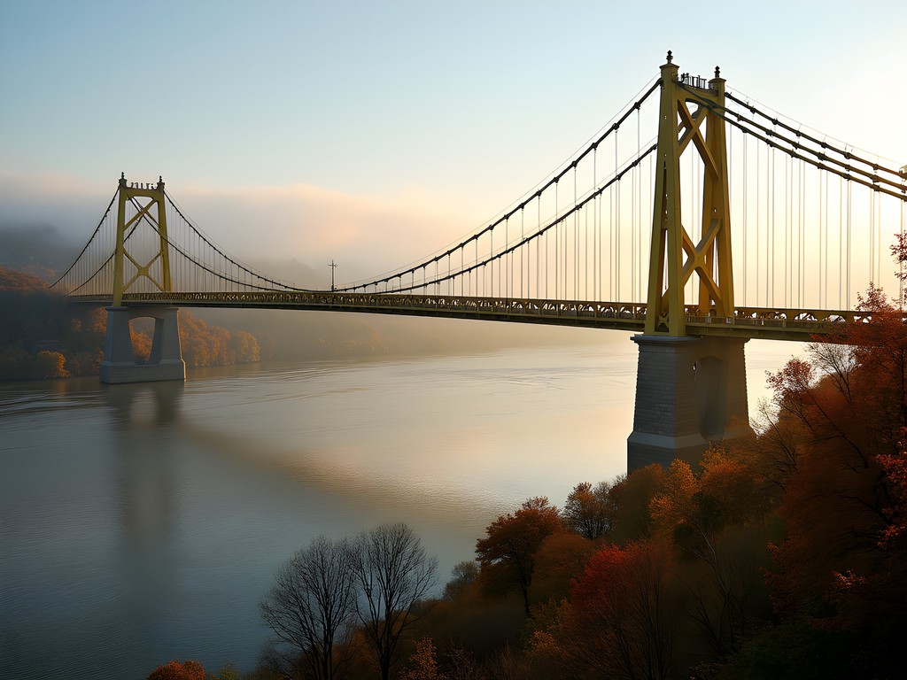
Few cities showcase the relationship between infrastructure and community formation better than Pittsburgh. With 446 bridges—more than Venice, Italy—these spans aren't merely transportation infrastructure but ecological corridors that facilitate human movement across natural barriers.
During my exploration, I developed a simple classification system for Pittsburgh's bridges based on their ecological function in the urban environment:
Keystone Bridges: Major spans like the yellow Three Sisters (Roberto Clemente, Andy Warhol, and Rachel Carson bridges) that serve as both physical and psychological connectors between distinct urban ecosystems.
Neighborhood Bridges: Smaller spans that create microconnections between adjacent communities, often developing their own distinct cultural identities.
Hidden Bridges: Forgotten spans, some now pedestrianized or abandoned, that offer quieter passages between neighborhoods and often harbor unexpected urban wildlife.
To document my bridge explorations, I used my trusty weatherproof notebook which proved invaluable during Pittsburgh's unpredictable fall weather. The ability to jot down observations even during light rain allowed me to maintain detailed field notes without retreating indoors.
My recommendation for serious urban explorers is to attempt a Three Rivers Bridge Walk—a self-guided tour crossing at least one span over each of Pittsburgh's rivers in a single day. This provides a comprehensive understanding of how water shaped the city's development patterns.
💡 Pro Tips
- The Hot Metal Bridge offers one of the best combinations of industrial history and river views
- Schedule bridge walks for early morning to avoid traffic and catch the fog rising from the rivers
- Download the Pittsburgh Bridges History app for self-guided tours with historical context
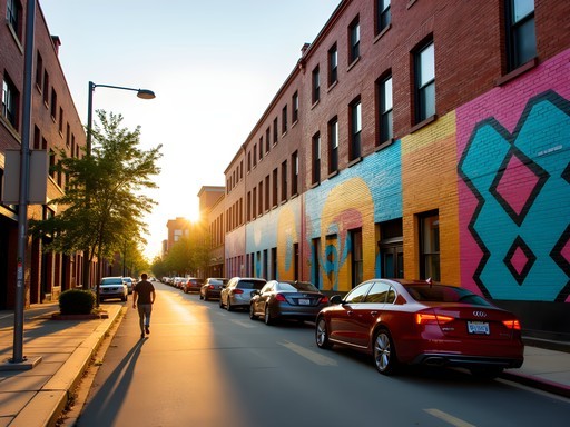
Hidden Neighborhoods: Pittsburgh's Micro-Ecosystems
Pittsburgh contains 90 officially recognized neighborhoods—an extraordinary number for a city its size—each functioning as a distinct micro-ecosystem with unique cultural and environmental characteristics. This neighborhood diversity stems directly from the city's fragmented topography, where hills and valleys naturally isolated communities and fostered independent development.
During my week of exploration, I focused on several neighborhoods that exemplify Pittsburgh's urban-nature interface:
Polish Hill: Wedged between larger neighborhoods and built on a steep incline, this former immigrant enclave features narrow streets, community gardens reclaiming vacant lots, and surprising pockets of urban wilderness.
Troy Hill: Perched above the Allegheny River, this hilltop neighborhood offers spectacular city views and contains Rosehill Street—one of Pittsburgh's steepest at a 24% grade.
Duck Hollow: A tiny riverside community accessible by just one road, this neighborhood exists in splendid isolation despite being within city limits. Its proximity to the Monongahela River creates a fascinating riparian ecosystem where urban and natural elements converge.
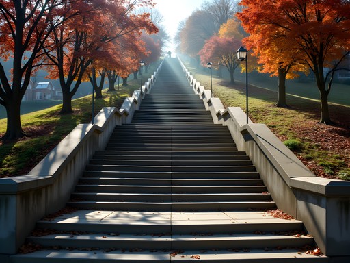
For my neighborhood explorations, my collapsible hiking poles proved surprisingly useful in navigating Pittsburgh's steepest streets and staircases. What might seem like overkill in other cities was genuinely practical here, especially when exploring the city's public staircases that climb hillsides at daunting angles.

💡 Pro Tips
- Use Pittsburgh's public staircases (there are over 800!) to discover hidden connections between neighborhoods
- Visit neighborhood business districts rather than downtown for authentic local experiences
- The South Side Slopes neighborhood contains the highest concentration of public staircases for urban hiking

The Inclines: Vertical Urban Exploration
No exploration of Pittsburgh's urban-nature interface would be complete without riding its two remaining historic inclines—the Duquesne and Monongahela Inclines. These funicular railways, built in the 1870s, remain functional pieces of public transportation while offering unparalleled perspectives on the city's relationship with its landscape.
As someone who studies how humans navigate challenging natural environments, I find these inclines fascinating. They represent a 19th-century solution to urban mobility that remains relevant today, predating modern conversations about sustainable transportation by over a century.
The Monongahela Incline ascends 367 feet at a 35-degree angle, delivering passengers to Mount Washington—a neighborhood perched high above the city offering Pittsburgh's definitive panorama. From this vantage point, the relationship between the built environment and natural topography becomes strikingly clear.
For capturing these dramatic elevation changes, my smartphone lens kit proved invaluable, allowing me to capture wide-angle shots of the cityscape that conventional smartphone photography couldn't achieve. The distinctive look of the anamorphic lens added a cinematic quality to my urban landscape photography.
I recommend visiting the inclines at different times of day—morning fog rising from the rivers creates an ethereal atmosphere, while evening views showcase the city lights reflecting on the water. Each perspective reveals different aspects of Pittsburgh's urban ecosystem.
💡 Pro Tips
- Purchase a round-trip ticket on the inclines to save money
- Visit on weekdays to avoid tourist crowds, especially during fall foliage season
- The upper stations of both inclines connect to interesting neighborhoods worth exploring beyond just the viewing platforms
Urban Trails: Pittsburgh's Green Network
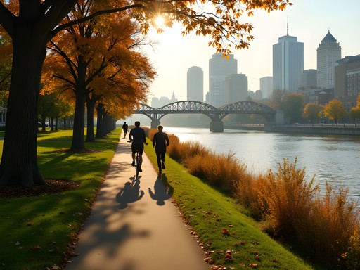
What surprised me most about Pittsburgh was its extensive network of urban trails—not just formal parks but linear green corridors that follow former industrial routes, abandoned rail lines, and riverfront paths. These trails form crucial habitat corridors in the urban environment while providing sustainable transportation alternatives.
The Three Rivers Heritage Trail system spans over 33 miles along all three rivers, connecting diverse neighborhoods through a continuous green corridor. As a forest ranger accustomed to more remote trails, I was impressed by how these urban pathways maintain ecological integrity despite their proximity to dense development.
The Eliza Furnace Trail (locally known as the 'Jail Trail') parallels a busy highway but creates a protected corridor for bike commuters and recreational users. The juxtaposition of speeding cars and peaceful trail users exemplifies Pittsburgh's ongoing negotiation between industrial legacy and environmental reclamation.
For early morning trail exploration, my insulated travel mug became an essential companion. Pittsburgh's fall mornings can be surprisingly chilly, and having hot coffee while watching the sunrise from riverside trails became my daily ritual. The mug's durability also withstood being repeatedly stashed in my pack during photography stops.
Don't miss the Duck Hollow Trail, which provides access to a fascinating post-industrial landscape where nature is actively reclaiming former industrial sites. The ecological succession visible here offers a living laboratory of urban rewilding that tells a hopeful story about environmental resilience.

💡 Pro Tips
- The Great Allegheny Passage connects to Pittsburgh's trail network, offering longer adventures extending all the way to Washington DC
- Download the TrailLink app for detailed maps of Pittsburgh's urban trail system
- Morning hours offer the best wildlife viewing opportunities on riverfront trails
Final Thoughts
As my week in Pittsburgh came to a close, I found myself reflecting on how this city represents a compelling case study in urban-nature coexistence. What began as a landscape that challenged conventional urban development has evolved into a place where those very challenges created something unique and resilient. Pittsburgh's bridges don't just span rivers—they connect distinct urban ecosystems. Its neighborhoods aren't just administrative districts—they're micro-environments shaped by topography and human adaptation. Its inclines and staircases aren't just transportation—they're ingenious solutions to environmental constraints.
For the urban explorer seeking to understand how cities and nature can coexist, Pittsburgh offers rich terrain for discovery. Beyond the familiar downtown skyline lies a complex network of communities, each with its own relationship to the surrounding landscape. As climate change forces cities everywhere to reconsider their environmental relationships, Pittsburgh's long history of adapting to challenging topography provides valuable lessons in urban resilience. I came seeking bridges and inclines but discovered a city that itself serves as a bridge between industrial history and a more sustainable urban future.
✨ Key Takeaways
- Pittsburgh's 446 bridges create a unique urban ecosystem where infrastructure and nature coexist in remarkable balance
- The city's steep topography produced distinct neighborhood micro-environments worth exploring beyond tourist districts
- Fall offers the ideal combination of comfortable temperatures and spectacular foliage for urban exploration
- Public staircases and historic inclines provide unique vertical perspectives on the city's development patterns
📋 Practical Information
Best Time to Visit
Mid-September to late October
Budget Estimate
$75-125 per day including accommodations
Recommended Duration
5-7 days
Difficulty Level
Moderate


Comments
wintervibes
That shot of downtown from Mt. Washington is incredible! Perfect timing with the sunset.
coolbuddy
Love the photos of the bridges! Pittsburgh has more bridges than Venice, right?
Gregory Boyd
That's correct! Pittsburgh has 446 bridges within city limits, which is more than Venice. It's often called the "City of Bridges" for good reason.
Sage Dixon
This post brought back so many memories! I grew up near Pittsburgh and recently returned after 15 years away. The transformation is incredible, but what I love is how the city has embraced its unique landscape rather than fighting against it. Last visit, I hiked from the South Side up to Grandview Avenue via public stairs - there are nearly 800 sets of public stairs throughout Pittsburgh! It's literally a vertical hiking city. The locals call them "city steps" and they're remnants from when workers needed to get down the hills to factories. I used my trail guide to find the most scenic routes. The Fineview neighborhood has one of my favorite sets with incredible city views most tourists never see.
vacationwanderer
Going to Pittsburgh in October! Which hidden neighborhoods would you recommend for someone with just 2 days?
Sage Dixon
Not Henry, but I'd recommend Lawrenceville for food/shops and Polish Hill for views. If you have time, the Strip District in the morning is a must for local flavor!
vacationwanderer
Thank you! Adding these to my itinerary right now.
Gregory Boyd
Henry, your analysis of Pittsburgh's topography is spot on. I visited last year and was struck by how the city's geography has shaped its development. The way neighborhoods are isolated yet connected is fascinating from an urban planning perspective. I spent three days just exploring different bridges and hillside communities. The contrast between the industrial history and the modern tech presence creates an interesting urban dynamic that's rare in American cities. Did you get a chance to explore the North Shore trail system? The bike paths there offer another perspective of the city's relationship with its rivers.
coolbuddy
North Shore trails are awesome! We rented bikes there last summer and loved it.
dreamexplorer
Pittsburgh has been on my list forever! Those inclines look amazing, definitely want to try them.
Gregory Boyd
The Duquesne Incline gives you the best view of the city skyline. Worth every penny!
dreamexplorer
Thanks for the tip! Adding it to my must-do list.
steelcityfan
As a Pittsburgh native, you really captured our city beautifully! Love seeing visitors appreciate our bridges and neighborhoods.
wanderlustadventurer
This is exactly what I needed! Been wanting to visit Pittsburgh but didn't know where to start. The way you described it as an urban forest really resonates - I love cities that blend nature and architecture. Definitely doing the Mount Washington incline for those views. Thanks for sharing this guide!
tripking
Going next month and SO PUMPED after reading this!! The inclines look amazing!
sunsetstar
The bridge photos are gorgeous! Really captured the vibe.
Venture X
Premium card with 2X miles, $300 travel credit, Priority Pass