
Disclosure: This article contains affiliate links. We may earn a commission from purchases at no extra cost to you, which helps our travel content.
Standing at 4,200 meters on the flanks of Chimborazo, watching Andean condors ride thermal currents above páramo grasslands, I realized why Ambato remains Ecuador's best-kept mountaineering secret. While tourists flock to Quito and Baños, this central highland city offers access to some of South America's most dramatic volcanic landscapes—without the crowds. My research on high-altitude ecosystems brought me here, but the raw beauty and technical challenges kept me returning with groups of experienced trampers eager for proper adventure.

Understanding Ambato's Volcanic Geography
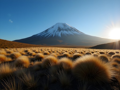
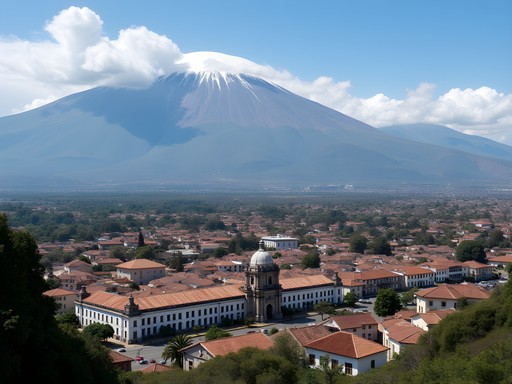
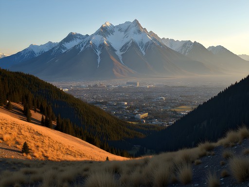
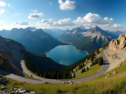
Ambato sits at 2,577 meters in a valley surrounded by five major volcanic peaks: Chimborazo (6,263m), Carihuairazo (5,020m), Tungurahua (5,023m), Altar (5,319m), and Sangay (5,230m). This isn't your casual weekend tramping—these mountains demand respect, proper acclimatization, and technical skills.
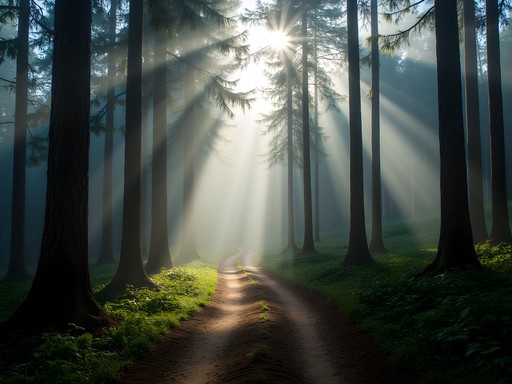
The region's geology fascinates me as a biologist. The volcanic soils create unique microclimates supporting endemic species found nowhere else. The páramo ecosystem—that high-altitude grassland between treeline and permanent snow—hosts specialized flora adapted to intense UV radiation, temperature extremes, and thin air. I've documented hummingbird species here feeding at elevations that would leave most birds gasping.
For groups tackling these peaks, understanding altitude physiology isn't optional. Your body needs time to produce additional red blood cells and adjust to reduced oxygen. I always recommend using a pulse oximeter to monitor your blood oxygen saturation during acclimatization days—it's saved more than one expedition I've guided from dangerous altitude sickness.

💡 Pro Tips
- Spend minimum three days acclimatizing in Ambato (2,577m) before attempting peaks above 4,500m
- Monitor symptoms of acute mountain sickness religiously: headache, nausea, dizziness warrant immediate descent
- Hire local guides from indigenous communities—their traditional knowledge of weather patterns and route conditions is invaluable
The Chimborazo Circuit: Ecuador's Ultimate Challenge
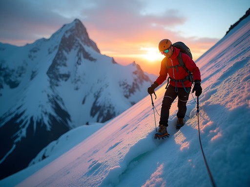
The three-to-four-day Chimborazo circuit remains the crown jewel for experienced groups. This isn't a guided tour—it's a proper mountaineering expedition requiring technical skills, self-sufficiency, and mental fortitude.
The standard route begins at the Carrel Refuge (4,850m), following the Whymper route toward the summit. Most groups attempt the summit push around midnight, navigating mixed snow, ice, and rock in the darkness. The final 300 meters involve technical climbing on 50-degree ice slopes. My Māori grandfather taught me that mountains demand humility—Chimborazo reinforces that lesson with every step.
Even if your group doesn't summit (weather, conditions, or acclimatization issues turn back 40% of attempts), the circuit offers extraordinary high-altitude trekking. The western flanks traverse lunar-like volcanic desert, while the northern route crosses glacial moraines and past ice caves.
Proper nutrition becomes critical above 4,000 meters. Your body burns calories at an accelerated rate while appetite often disappears. I've found that energy bars work brilliantly because they're palatable even when you're knackered and nauseous, plus they don't freeze solid like gels.

💡 Pro Tips
- Book Carrel Refuge accommodation weeks in advance during June-August peak season
- Bring crampons, ice axe, helmet, and harness—rental quality in Ambato is questionable
- Start summit attempts between midnight and 2am to ensure descent before afternoon weather deteriorates
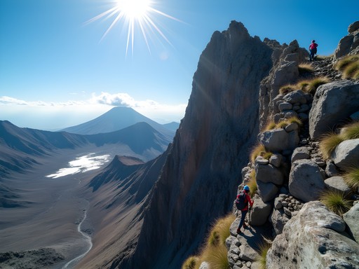
Carihuairazo: Technical Scrambling Paradise
While Chimborazo gets the glory, neighboring Carihuairazo offers equally spectacular climbing with less altitude stress. This extinct volcano's three peaks—Mocha Grande, Mocha Chico, and the Pollito—provide varied routes from moderate scrambles to technical rock climbing.
I particularly rate the northern route approaching from the Mechahuasca valley. The two-day expedition crosses pristine páramo, camps at 4,400 meters beside glacial tarns, then tackles the summit via mixed terrain requiring both rock scrambling and snow climbing skills. The views across to Chimborazo and down into the Amazon basin are absolutely gobsmacking.
The rock here is volcanic andesite—generally solid but requiring careful testing. Groups should include members comfortable with Class 3-4 scrambling and basic rope work. We typically bring a climbing rope for the steeper sections, particularly the final summit ridge where exposure increases dramatically.
What makes Carihuairazo special is the wildlife. I've documented Andean foxes, white-tailed deer, and once—memorably—a mountain tapir at dawn. The páramo ecosystem here remains relatively undisturbed, offering glimpses of how these highlands appeared before heavy agricultural pressure.

💡 Pro Tips
- Approach from Urbina village where local guides offer mule support to base camps
- The summit push involves 800m elevation gain over challenging terrain—start early
- Bring proper rock climbing gloves; the volcanic rock shreds standard hiking gloves within hours

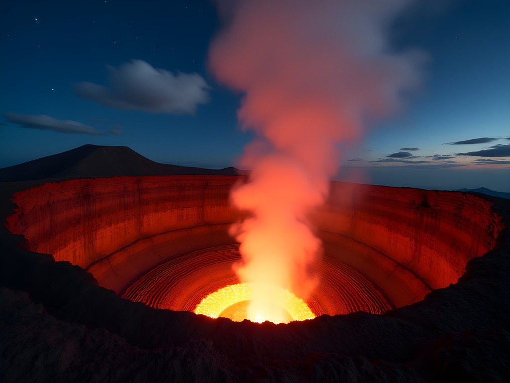
Tungurahua: Hiking an Active Volcano
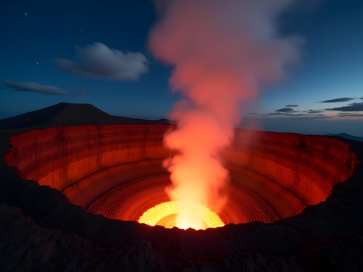
Here's where things get properly interesting. Tungurahua—'Throat of Fire' in Kichwa—has been continuously active since 1999. The volcano's status changes frequently, and summit access depends entirely on current activity levels. When I last guided a group in 2022, we reached the Refugio at 3,800m but couldn't proceed higher due to increased seismic activity.
Even without summiting, the approaches to Tungurahua offer spectacular hiking. The route from Baños through Pondoa and up to the refuge traverses cloud forest transitioning to páramo, with constant views of the smoking crater. Night hikes reveal the crater's incandescent glow—a humbling reminder of the massive geological forces beneath your boots.
Monitoring volcanic activity requires checking IGEPN (Ecuador's Geophysical Institute) daily reports. Don't rely solely on local tour operators—some prioritize profit over safety. A quality satellite communicator becomes essential here, as mobile coverage disappears above 3,000m and conditions can change rapidly.
The scientific side of me finds active volcanoes endlessly fascinating. The gas emissions, thermal features, and pioneer plant species colonizing recent lava flows provide real-time lessons in ecological succession and geological processes.
💡 Pro Tips
- Check IGEPN volcanic activity reports daily: www.igepn.edu.ec
- Hire guides from Baños who maintain radio contact with volcano monitoring stations
- Bring dust masks or buffs—volcanic ash can irritate respiratory systems even during quiet periods
Practical Logistics for Group Expeditions
Organizing advanced mountain expeditions in Ecuador requires more planning than your standard tramping trip. Ambato serves as the logical base—it's large enough for proper supplies but small enough to avoid Quito's chaos.
Accommodation ranges from budget hostels to mid-range hotels. I typically book groups into Hotel Ambato or Hotel Miraflores, both offering secure gear storage, early breakfast arrangements, and connections to reputable guide services. Budget $40-60 USD per night for decent digs.
For provisions, Supermaxi and Tía supermarkets stock adequate camping food, though I supplement with items brought from Canada—proper freeze-dried meals, energy foods, and water treatment supplies. The local markets offer fresh produce perfect for acclimatization days.
Guide services vary dramatically in quality. I work with indigenous-run cooperatives from the Chimborazo region whose traditional knowledge complements technical mountaineering skills. They charge $150-200 USD daily for experienced guides, but their weather prediction abilities and route knowledge justify every penny.
Transport to trailheads requires 4WD vehicles. Most hotels arrange this, or guides include it in packages. Budget $80-120 USD for return trips to major trailheads.

💡 Pro Tips
- Exchange currency in Ambato—Ecuador uses USD but remote areas may lack change for large bills
- Purchase comprehensive travel insurance covering mountaineering above 6,000m—many standard policies exclude this
- Arrange satellite communication before departure; rental options exist in Quito but not Ambato
Final Thoughts
Ambato's volcanic landscapes offer experienced groups something increasingly rare: genuine adventure in spectacular, uncrowded mountains. These aren't Instagram peaks where you queue for summit photos—they're serious objectives demanding technical skills, physical fitness, and proper respect for altitude and weather.
My research here continues revealing how specialized ecosystems adapt to volcanic disturbance and extreme altitude. But beyond the science, these mountains remind me why I fell in love with wild places. Standing on Chimborazo's summit, watching the curvature of the Earth become visible, feeling utterly insignificant yet deeply connected—that's what proper mountaineering delivers.
For groups seeking challenge, beauty, and the satisfaction of genuine achievement, Ambato's volcanic amphitheater rewards those willing to put in the effort. Just remember: the mountains will be here long after we're gone. Climb responsibly, support local communities, and leave nothing but crampon marks in the snow.
Kia kaha—stay strong out there.
✨ Key Takeaways
- Ambato provides access to five major volcanic peaks requiring advanced mountaineering skills and proper acclimatization
- The Chimborazo circuit represents Ecuador's ultimate high-altitude challenge, demanding technical ice climbing abilities
- Active volcano status changes frequently—monitor IGEPN reports daily and prioritize safety over summit fever
📋 Practical Information
Best Time to Visit
June through August (dry season), December-January secondary window
Budget Estimate
$1,200-1,800 USD per person for week-long expedition including guides, accommodation, transport, and permits
Recommended Duration
7-10 days minimum including acclimatization
Difficulty Level
Advanced—requires Technical Mountaineering Skills, High-Altitude Experience, Excellent Fitness


Comments
explorenomad6228
Is Tungurahua safe to hike right now?? I thought it was still active?
Claire Hawkins
It is active! You need to check with local authorities and go with certified guides. They monitor activity daily and some trails close depending on volcanic activity levels.
Claire Hawkins
Joshua, this post brings back so many memories! We visited Ambato last year with our two kids (8 and 10 at the time) and while we couldn't tackle Chimborazo, we did some lower altitude trails around the city. The views of Tungurahua were mesmerizing, especially at sunset. One thing I'd add for families - the Quinua market on Saturdays is wonderful for restocking supplies and the locals were so welcoming to our children. We stayed three days longer than planned because everyone fell in love with the páramo landscapes. Did you experience any altitude sickness at 4,200m? We struggled a bit even at 3,000m coming from sea level.
explorenomad6228
How long did you acclimate before going up? I'm planning a trip and worried about the altitude!
Claire Hawkins
We spent 3 days in Quito first (2,850m) then 2 days in Ambato before attempting any hikes. Coca tea helped a lot! Take it slow and listen to your body.
mountainlegend
This looks absolutely incredible! Adding to my bucket list!
Venture X
Premium card with 2X miles, $300 travel credit, Priority Pass