


Disclosure: This article contains affiliate links. We may earn a commission from purchases at no extra cost to you, which helps our travel content.
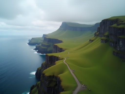
The first time I stood atop Slættaratindur—the highest peak in the Faroe Islands—I felt like I was perched on the edge of the world. Below me, emerald valleys carved by ancient glaciers tumbled toward a coastline where the restless North Atlantic hammered relentlessly against sheer cliffs. The archipelago's 18 islands, scattered like emerald shards across the sea between Iceland and Norway, have remained one of Europe's best-kept secrets for adventurous hikers. After spending years guiding craft-focused tours through the Andes, I found myself drawn to these remote Danish islands for their raw, untamed landscapes that seem crafted by some divine hand—much like the intricate woodwork my Lebanese father once taught me to appreciate. This past summer, I dedicated a week to exploring the archipelago's most dramatic trails, discovering that hiking the Faroes isn't just about conquering peaks—it's about experiencing a landscape where traditional shepherding paths have connected communities for centuries, weaving together nature and human craftsmanship in the most elemental way.

Preparing for Faroese Weather: The Fifth Season
Locals joke that the Faroe Islands have five seasons per day, not four per year. During my week-long hiking adventure in July, I experienced everything from brilliant sunshine to sideways rain within hours. This unpredictability isn't just folklore—it's essential knowledge for any serious hiker.
On my second morning, I woke to crystal clear skies in Tórshavn, the charming capital. By the time I reached the trailhead for Villingardalsfjall (an hour's drive away), fog had swallowed the mountain whole. Rather than turning back, I waited. My patience was rewarded when, 45 minutes later, the clouds lifted just enough to reveal the path forward.
This taught me the most valuable lesson about hiking in the Faroes: flexibility is non-negotiable. Never commit to a single trail on any given day. Instead, have 2-3 options mapped out across different parts of the islands, and make your decision based on where the weather cooperates.
Layering is absolutely essential here. I relied heavily on my waterproof hiking jacket which proved its worth repeatedly when sudden downpours appeared from seemingly clear skies. Unlike my experiences in the Andes where weather patterns follow more predictable rhythms, the Faroes demand constant readiness for dramatic shifts.
💡 Pro Tips
- Check weather forecasts for multiple locations across the islands each morning
- Always carry waterproof layers regardless of the forecast
- Consider booking accommodations in different parts of the archipelago to maximize hiking opportunities
Slættaratindur: The Crown Jewel
At 880 meters (2,887 feet), Slættaratindur isn't particularly imposing by international standards. Yet what it lacks in height, it makes up for in pure drama and panoramic payoff. The trail begins near the village of Eiði on Eysturoy island, and while the elevation gain is modest by mountaineering standards, the constantly shifting weather adds layers of complexity.
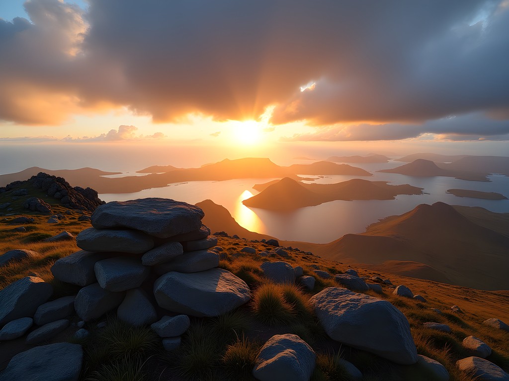
I started my ascent at 5:30 AM, hoping to catch the legendary summer sunrise where, on clear days, you can supposedly see all the way to Iceland. The lower portion of the trail meanders through sheep pastures, marked by cairns (stone stacks) that have guided travelers for centuries. These human-made markers reminded me of the artisanal trail markers I'd encountered in remote Chilean mountain passes—functional art born of necessity.
The final 300 meters involve some light scrambling over loose scree and larger boulders. Nothing technical, but definitely requiring attention, especially in wet conditions. I'd recommend wearing proper hiking boots with ankle support rather than trail runners here—the extra stability saved me from a twisted ankle at least twice on the descent.
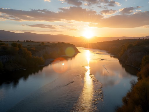
When I reached the summit plateau, the morning fog parted just enough to create what photographers call 'god rays'—shafts of golden light breaking through clouds to illuminate the patchwork of islands below. Though I didn't quite see Iceland (maybe next time!), the 360-degree views of virtually the entire archipelago justified every step of the climb. I shared the summit with only two local hikers who told me about the midsummer tradition where islanders climb Slættaratindur on the longest day of the year to watch the sun briefly set and immediately rise again.
💡 Pro Tips
- Start early (before 7 AM) to avoid afternoon fog that frequently obscures the summit
- Bring trekking poles for the descent, as the scree can be treacherous
- Pack a lightweight insulated jacket—even in summer, the summit temperatures can drop below 5°C (41°F)
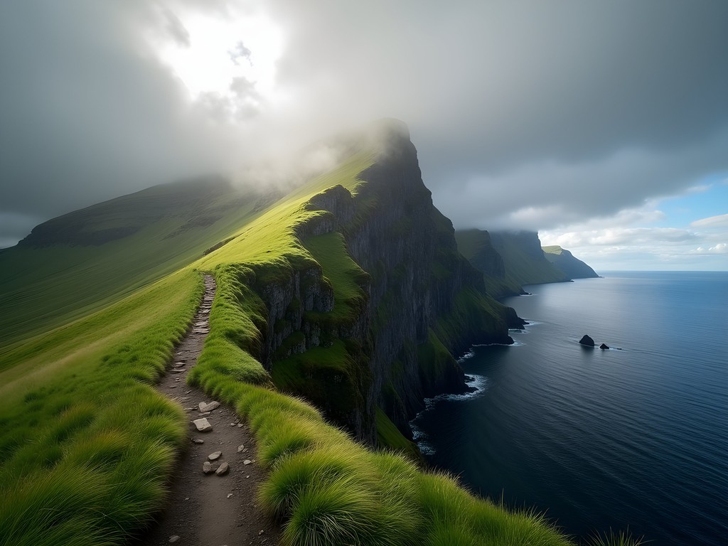
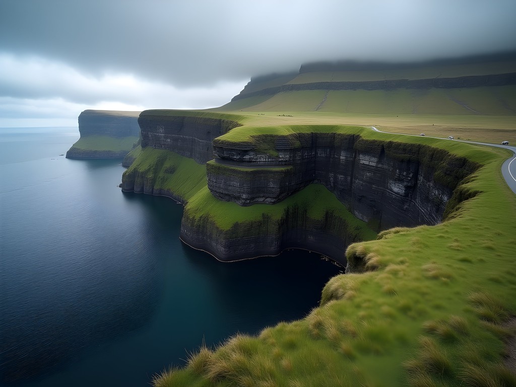
The Mythical Hike to Trælanípa (Slave Cliff) & Bøsdalafossur
Some landscapes feel so otherworldly they seem to exist between reality and legend. The hike to Trælanípa (Slave Cliff) and the waterfall Bøsdalafossur on Vágar island perfectly embodies this feeling. This moderate 3-4 hour roundtrip hike offers what might be the most photographed view in the Faroes: the optical illusion where Lake Leitisvatn appears to hover hundreds of meters above the ocean.
I began this hike from the small village of Miðvágur, though many visitors start from the closer parking area near the lake. The trail skirts the edge of Lake Leitisvatn, the largest lake in the Faroes, before gradually climbing toward the sea cliffs. What makes this hike unique is the juxtaposition of elements: to your left, a calm freshwater lake; ahead, the thundering North Atlantic; and between them, a narrow strip of land culminating in vertical cliffs.
As a craftsperson's daughter, I couldn't help but see the landscape as a masterful composition—the way the elements balance each other reminded me of my mother's woven tapestries, where contrasting colors and textures create harmony through opposition.
The most challenging aspect of this hike isn't the terrain but the exposure. The famous viewpoint requires standing near cliff edges with 300+ meter drops to the ocean below. There are no guardrails, and fierce winds can gust unexpectedly. My compact binoculars proved invaluable here, allowing me to spot puffins nesting on the cliffs and appreciate details of the landscape without venturing too close to the edges.
The trail continues to Bøsdalafossur, where Lake Leitisvatn spills directly into the ocean through a small waterfall. Standing at this intersection of freshwater and saltwater, with seabirds circling overhead, I felt I'd discovered the Faroes' true essence—a place where boundaries blur and natural elements converge in unexpected ways.
💡 Pro Tips
- Stay at least 2 meters back from cliff edges, especially in windy conditions
- Wear waterproof hiking pants—the grass is often wet even on sunny days
- Allow extra time for photography—the changing light creates dramatically different scenes throughout the day

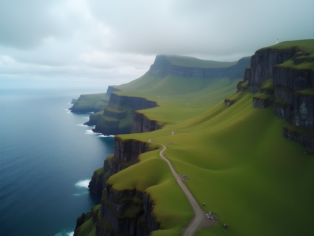
Navigating the Remote Trail to Kallur Lighthouse
My most adventurous day in the Faroes began with a ferry ride to Kalsoy, often called 'the flute' due to its long, narrow shape punctuated by tunnel 'holes.' This island has no hotels, just a handful of residents in four tiny villages, and one spectacular hiking destination: the Kallur Lighthouse.
The journey itself is part of the adventure. After catching the small car ferry from Klaksvík (book ahead in summer!), I drove north through four narrow single-lane tunnels carved through mountains to reach the northernmost village of Trøllanes. This remote hamlet of just a few houses serves as the trailhead.
The path to the lighthouse isn't technically difficult, but it's wonderfully wild. The trail crosses open moorland where sheep roam freely, then follows a narrowing ridge toward the island's northern tip. The constant presence of the ocean on both sides creates an extraordinary sense of exposure. About halfway through, I encountered a local shepherd repairing a stone wall using techniques that haven't changed for centuries—a perfect example of how traditional craftsmanship remains essential to daily life in the Faroes.
As the lighthouse came into view, so did the infamous 'secret viewpoint'—a narrow ridge with precipitous drops on both sides leading to a rocky outcrop. This spot recently gained fame as a filming location for a James Bond movie, but locals have known about it for generations. Accessing it requires a short but nerve-wracking traverse that I'd only recommend for experienced hikers comfortable with exposure. My hiking daypack with its close-fitting design and stability features proved essential here—the last thing you want on narrow ridges is a shifting pack throwing off your balance.
The view from the viewpoint is simply staggering—sheer cliffs plunging to the sea, the lighthouse perched precariously on its promontory, and on clear days, views to five other islands. It's the kind of wild, untamed landscape that reminds you of nature's raw power and beauty.
💡 Pro Tips
- Check ferry schedules carefully—missing the last ferry back means an unplanned overnight stay
- Bring a headlamp when hiking, as the single-lane tunnels have no lighting if you're walking through them
- Sign the guestbook at the lighthouse—it's become a tradition for hikers from around the world
Connecting with Local Craft: The Wool Route
Between my more strenuous hikes, I discovered what locals call 'The Wool Route'—a gentler walking path connecting the villages of Tórshavn and Kirkjubøur. This 7km coastal trail offers not just stunning scenery but a window into the Faroes' rich craft heritage.
The path follows ancient routes once used by villagers traveling between settlements, marked by cairns that shepherds have maintained for centuries. What makes this trail special is how it weaves together landscape and local craftsmanship. Along the way, you'll pass small stone shelters built by shepherds using dry-stack techniques passed down through generations—no mortar, just perfectly balanced stones creating structures that have withstood Atlantic gales for hundreds of years.
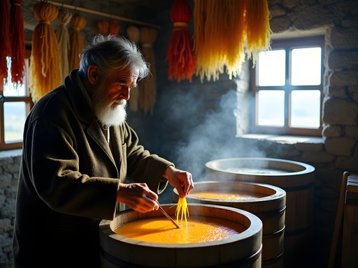
In Kirkjubøur, I visited the workshop of a traditional wool dyer who creates vibrant colors using local plant materials and lichen. The rich browns, yellows, and greens she produces echo the very landscape I'd been hiking through. As someone raised by a weaver mother, watching her work the wool with techniques virtually unchanged for centuries resonated deeply with me.
The famous Faroese sweaters (similar to their Icelandic cousins but with distinctive patterns) represent a perfect marriage of function and artistry. Knitted densely to repel the fierce weather, they feature patterns that often tell stories about island life or represent specific families. I couldn't resist purchasing a hand-knit hat made from local wool—both as a practical layer for my remaining hikes and as a meaningful souvenir connecting me to this landscape.
What struck me most was how the traditional crafts of the Faroes evolved in direct response to the mountains and weather I'd been experiencing. The wool from sheep grazing on these very slopes becomes the protection against the elements those same slopes create—a perfect circular economy that existed long before the term was coined.

💡 Pro Tips
- Visit the National Museum in Tórshavn before hiking the Wool Route to understand the historical context
- Bring cash for purchasing directly from artisans in smaller villages
- Learn a few phrases in Faroese—craftspeople appreciate the effort and often share more about their techniques
Final Thoughts
As my ferry pulled away from Tórshavn on my final day, the mountains of the Faroes seemed to rise from the mist like the backbone of some ancient creature—part of our world yet somehow separate, operating on their own rhythms and rules. What makes hiking in this archipelago so profound isn't just the dramatic landscapes or the technical challenges of the trails, but how deeply the mountains are woven into the cultural fabric of island life. Every path I walked felt like reading a story written in stone and grass, telling tales of how humans have moved through, respected, and adapted to these formidable peaks for a thousand years. The Faroe Islands offer something increasingly rare in our hyper-connected world: genuine wilderness that remains accessible yet untamed. For the solo hiker willing to embrace unpredictable weather and vertiginous trails, these islands provide not just adventure but perspective—a reminder that some landscapes still exist primarily on nature's terms, not ours. I'll be back, next time with more time to explore the outer islands and their even more remote trails.
✨ Key Takeaways
- The Faroe Islands offer world-class hiking with fraction of the crowds found in similar landscapes
- Weather dictates everything—flexibility in your hiking schedule is essential
- The most rewarding views often involve early starts and patience with changing conditions
- Local craft traditions provide deeper context for understanding the landscape and culture
📋 Practical Information
Best Time to Visit
June through August
Budget Estimate
$150-200 USD daily (including car rental)
Recommended Duration
7-10 days minimum
Difficulty Level
Moderate To Challenging

Comments
luckyvibes
Pro tip: the local wool sweaters aren't just souvenirs - they're perfect for Faroese hiking weather!
roamnomad
Just got back from the Faroes two weeks ago and followed your guide to Slættaratindur! The "fifth season" is NO JOKE! We experienced sunshine, rain, fog, and wind all within two hours. But that moment when the clouds parted at the summit and we could see five different islands... I literally cried it was so beautiful. Your tip about bringing layers saved us - I kept putting on and taking off my rain shell like a dozen times. THANK YOU for this amazing guide!!! Planning to try the Kallur Lighthouse hike next time!
vacationhero
Great post! I'm heading there in July. How many days would you recommend to do all these hikes? And is it possible to use public transport to reach most trailheads or should I rent a car?
Nova Perry
I'd allow at least 5-7 days for these hikes, especially considering weather delays. Public transport can get you to some trailheads, but a rental car gives you much more flexibility with the changeable weather. Some remote spots like Kallur Lighthouse require both driving and a ferry.
Sophia Gomez
Nova, this brought back so many memories! I'll never forget standing at Trælanípa watching that waterfall plunge straight into the ocean. The Faroes have this raw, untouched quality that's so rare nowadays. I actually met a local shepherd on the trail to Slættaratindur who told me stories about his grandfather herding sheep up there in winter - can you even imagine? The resilience of the Faroese people is as dramatic as the landscape itself. For anyone planning a trip: rent a car if you can. The buses run but having flexibility to chase good weather windows made all the difference for us.
coffeebuddy
Did the Kallur Lighthouse hike in 2024 and it was hands down one of the best trails I've ever done. That final ridge walk is no joke though - pretty exposed and windy. Started early morning and had the place completely to ourselves for about 30 minutes. The light hitting those cliffs was unreal. Pro tip: the trail from the parking area is muddy as hell, so waterproof boots are a must. Also grabbed a SIM card in Tórshavn which was clutch for navigation since some trails aren't super well marked.
mountainlover
omg the exposed ridge sounds scary but amazing! how long did the whole hike take you?
coffeebuddy
about 2 hours round trip with lots of photo stops. it's not super long but take your time on that ridge!
sunsetbuddy
how hard is the weather really? like do you need special gear or just normal rain jacket?
Sophia Gomez
Not Nova, but I hiked there last summer! The weather changes SO fast. I had sunshine, rain, and fog all in one hour on Slættaratindur. Definitely bring layers and a solid waterproof shell.
sunsetbuddy
ok good to know thanks!
mountainlover
This looks absolutely incredible!! Adding to my bucket list right now
Gregory Boyd
Excellent breakdown of the trails, Nova. I hiked most of these routes in 2021 and would emphasize your point about weather preparation. I tracked the conditions using three different weather apps and still got caught in unexpected fog on Slættaratindur. The visibility dropped to about 3 meters in minutes. My hiking GPS was absolutely essential that day. For those planning to visit, I'd recommend downloading offline maps for the entire archipelago before arrival as cell coverage can be spotty on the remote trails. The trail markers on some of the lesser-known paths can also be quite subtle - often just small cairns that are easy to miss in poor visibility.
luckyvibes
I got caught in that same fog situation last year! Paper map saved me.
wildway
That Kallur Lighthouse view is straight out of a fantasy movie! 😍
Riley Griffin
Nova, this brings back such memories! I took my family to the Faroes last summer and that hike to Trælanípa was a highlight for my kids (13 and 15). The local legend about slaves being pushed off the cliff was macabre but fascinating for them. One tip for families I'd add: the wind near Bøsdalafossur waterfall can be incredibly strong. We actually had our youngest hold hands with an adult when we got close to the edges. Also, we found having a picnic at Lake Leitisvatn was perfect timing halfway through the hike. The optical illusion of the lake appearing to hover above the ocean blew our minds!
Venture X
Premium card with 2X miles, $300 travel credit, Priority Pass