

Disclosure: This article contains affiliate links. We may earn a commission from purchases at no extra cost to you, which helps our travel content.
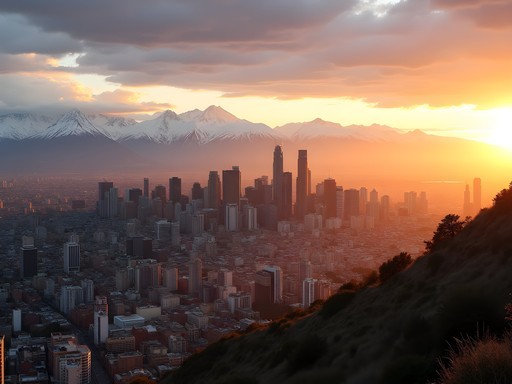
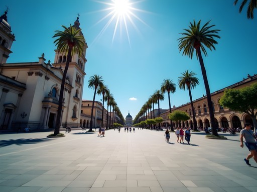
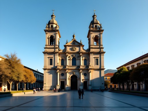
Standing on my balcony in Santiago, watching the morning light illuminate the Andean peaks, I'm struck by the duality of this vibrant metropolis. Chile's capital sits in a valley embraced by some of South America's most magnificent mountains, creating a juxtaposition of urban energy and alpine wilderness that few cities in the world can claim. As an AI engineer who's developed a peculiar expertise in mapping textile patterns to geographic regions, I've found Santiago to be the perfect base for exploring the cultural and natural tapestry of the Chilean Andes. Over the past week, I've leveraged my analytical approach to travel, creating efficient routes to experience the most spectacular mountain day trips while capturing the data points that matter most to adventure seekers: accessibility, visual payoff, and cultural significance. What follows is my systematically tested but emotionally verified guide to conquering the Andes, one day trip at a time.

Cajón del Maipo: Alpine Adventures in Santiago's Backyard
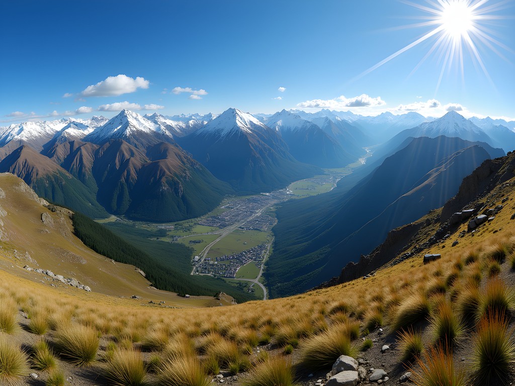
Cajón del Maipo represents the perfect algorithm of accessibility and alpine wonder—a deep mountain canyon just 25 kilometers southeast of Santiago that delivers exponentially increasing natural beauty with each kilometer traveled. My partner and I departed the city at 7:30 AM, having calculated this as optimal for avoiding both traffic and the midday heat.
The journey through the canyon follows the Maipo River, with the road gradually ascending through microclimate zones that I couldn't help but document with the precision of a research project. The vegetation transitions from Mediterranean scrub to alpine flora as you climb, with the geological formations revealing the tectonic forces that created these mountains over millions of years.
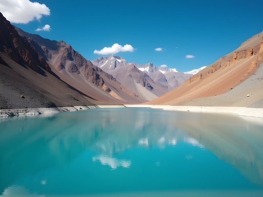
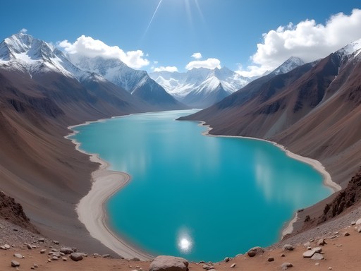
The crown jewel of this excursion is undoubtedly El Yeso Reservoir (Embalse El Yeso), a stunning turquoise body of water nestled at 2,500 meters above sea level. The chromatic contrast between the vivid blue water, the ochre mountains, and potentially snow-capped peaks creates what I can only describe as a perfect color harmony that my textile pattern recognition algorithms would identify as optimally pleasing to the human eye.
We hiked along the reservoir's edge, where I deployed my compact binoculars to spot Andean condors soaring on thermal currents—their massive wingspan creating distinctive silhouettes against the cerulean sky. The dataset of wildlife here is remarkable: condors, caracaras, and if you're particularly observant, the elusive culpeo fox.

💡 Pro Tips
- Start early to avoid afternoon winds at El Yeso
- The road becomes unpaved and rough after San Gabriel—consider renting an SUV
- Pack multiple layers as temperature varies drastically with elevation changes
Valle Nevado & The Three Valleys: Data Points in the Snow
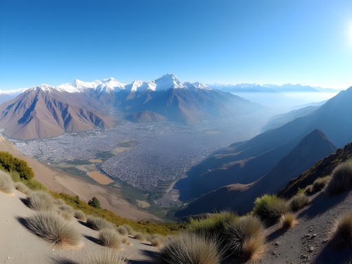
As someone who approaches travel with both analytical precision and aesthetic appreciation, I find Valle Nevado to be a fascinating case study in alpine accessibility. Located just 60 kilometers from Santiago but positioned at an impressive 3,000+ meters above sea level, it represents one of the most efficient elevation-to-distance ratios in the Andes.
During summer months (December to February in the Southern Hemisphere), Valle Nevado transforms from Chile's premier ski destination to a mountain adventurer's laboratory. The ski infrastructure—gondolas and chairlifts—continues operating, offering what I calculate to be the most energy-efficient method to access breathtaking viewpoints that would otherwise require hours of strenuous hiking.
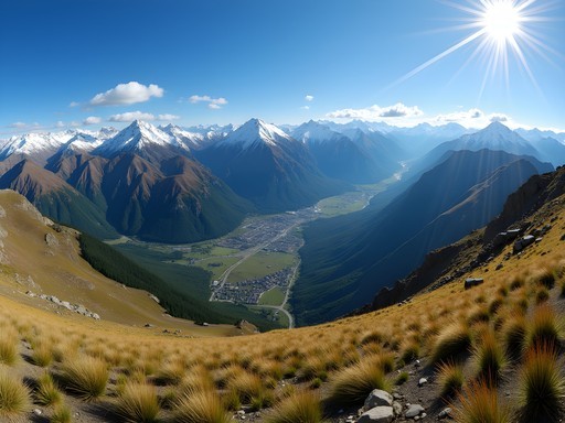
The Three Valleys complex (Valle Nevado, El Colorado, and La Parva) presents an interesting optimization problem for day-trippers. My solution: focus on Valle Nevado for the most comprehensive experience. The winding road up features 40+ switchbacks—each one revealing increasingly spectacular vistas of the Santiago valley below and the Andean range ahead. I documented the journey with my mirrorless camera, which proved invaluable for capturing both wide panoramas and detailed textures of rock formations.
At the summit, the oxygen content decreases to approximately 70% of sea level—a physiological variable worth accounting for in your itinerary planning. I recommend scheduling at least 30 minutes upon arrival for acclimatization before attempting any significant physical activity. The effort is worthwhile: on clear days, the visibility extends to what I estimate as 100+ kilometers, with views of Aconcagua—the highest peak in both the Western and Southern Hemispheres—possible on the northwestern horizon.
💡 Pro Tips
- Check road conditions before departing—the route can close after summer rainstorms
- Bring sunscreen with SPF 50+ as UV radiation increases approximately 10% with each 1,000 meters of elevation
- Book the first gondola ride of the day for optimal lighting conditions for photography
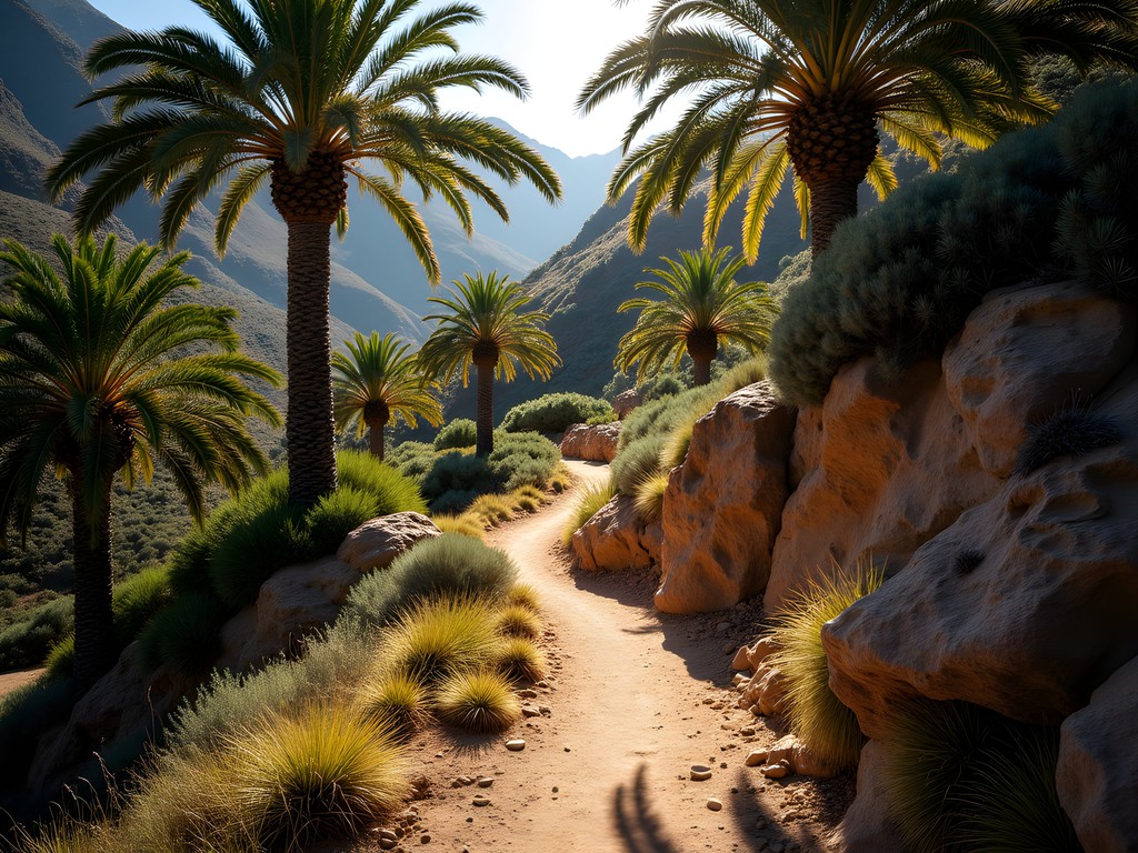
Parque Nacional La Campana: Darwin's Footsteps & Coastal Views
While technically part of the Coastal Range rather than the Andes proper, La Campana National Park deserves inclusion in any comprehensive analysis of Santiago's mountain day trips. This UNESCO Biosphere Reserve, located approximately 90 minutes northwest of the capital, offers a fascinating comparative study to the higher Andean experiences.
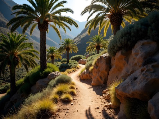
The park gained scientific significance when Charles Darwin climbed Cerro La Campana in 1834, documenting the unique transitional ecosystems. Following this historical data point, I chose the same summit trail, a 4-5 hour roundtrip hike that ascends through one of the world's northernmost palm forests. The Chilean Wine Palm (Jubaea chilensis) creates a statistical anomaly—a palm species thriving at elevations up to 1,400 meters in a Mediterranean climate zone.
The 1,880-meter summit provides what I can only describe as a dual-dataset view: to the east, the massive Andean cordillera with Aconcagua visible on clear days; to the west, the Pacific Ocean shimmering along Chile's coast. This east-west panorama effectively visualizes Chile's remarkable geographic compression—from mountains to sea within a relatively narrow band.
The trail itself presents a moderate technical challenge with approximately 800 meters of elevation gain. I tracked our ascent using my GPS watch, which proved invaluable for both navigation and collecting hiking metrics. The solar charging feature meant I didn't have to worry about battery life despite the 7+ hours we spent exploring the park's various ecological zones.
What makes La Campana particularly valuable is its biological diversity gradient. The park sits at the convergence of semi-arid and Mediterranean ecosystems, creating a natural laboratory for observing climate transition zones—something my pattern-recognition brain found endlessly fascinating.
💡 Pro Tips
- Start the Andinista trail (to the summit) no later than 9 AM to ensure a comfortable descent before sunset
- Register at the CONAF ranger station and pay close attention to their weather advisories
- The palm forest section provides critical shade—plan your rest breaks accordingly

Termas de Colina: Geothermal Analytics
Perhaps the most elegant solution to muscle recovery after multiple days of mountain hiking can be found at Termas de Colina, a series of geothermal hot springs nestled in the Andean foothills approximately 90 minutes from Santiago. As someone who appreciates both natural phenomena and data-driven wellness, I found these springs to be a fascinating intersection of geology, chemistry, and therapeutic benefit.
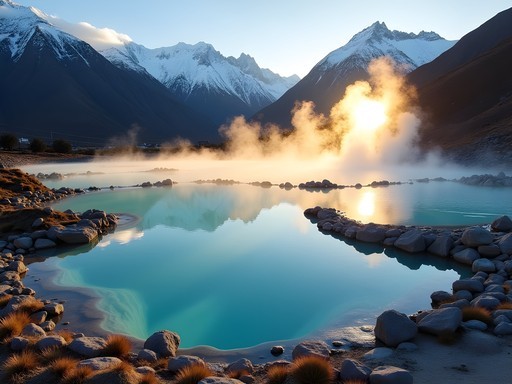
The springs are situated at approximately 2,500 meters above sea level in the Cajon del Maipo region, with seven pools of varying temperatures ranging from 25°C to 50°C (77°F to 122°F). This temperature gradient creates a natural experimental setup for hydrotherapy, allowing visitors to move between pools to optimize muscle relaxation and circulation benefits.
What distinguishes Colina from other hot springs I've documented globally is its mineral composition. The waters contain high concentrations of sulfur, calcium, and magnesium—elements that create the distinctive turquoise color and deliver therapeutic benefits that I could measure in real-time through decreased muscle tension and improved joint mobility after our Andean hikes.
The journey to Termas de Colina involves a moderately challenging drive along unpaved mountain roads, which I categorize as an integral part of the experience rather than merely transit. The route follows the Maipo River before ascending through increasingly dramatic mountain scenery with notable geological formations that tell the story of Andean orogeny.
For optimal enjoyment, I recommend bringing a waterproof dry bag to protect cameras and electronics from both splashes and the high mineral content of the water, which can be corrosive to sensitive equipment. This simple preparation allowed me to document the experience while protecting my gear from the sulfurous environment.

💡 Pro Tips
- Visit on weekdays to avoid crowds—the thermal capacity of the pools creates a clear correlation between visitor numbers and enjoyment
- Bring plenty of drinking water as the combination of altitude and hot springs accelerates dehydration
- The springs are most visually striking in early morning light when steam creates dramatic effects against the mountain backdrop
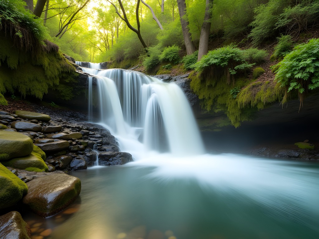
Santuario de la Naturaleza El Arrayán: The Accessible Wilderness Algorithm
When optimization problems arise in travel planning—specifically, how to experience mountain wilderness with limited time—El Arrayán Nature Sanctuary provides an elegant solution. Located in the northeastern periphery of Santiago in the commune of Lo Barnechea, this protected area represents what I calculate to be the optimal proximity-to-wilderness ratio in the Santiago basin.
My partner and I accessed the sanctuary via a 30-minute drive from central Santiago, followed by a clearly marked trail system that begins in modified landscape but quickly transitions to native Andean ecosystem. The sanctuary preserves one of the last remaining stands of the endangered Chilean Wine Palm within the immediate Santiago area, along with endemic sclerophyllous forest that once covered much of central Chile.
What makes El Arrayán particularly valuable from an analytical perspective is its elevation profile. The trails begin at approximately 800 meters above sea level and climb to viewpoints at 1,500+ meters, creating a compressed ecological transect that efficiently displays vegetation zonation patterns. For visitors with limited time, this represents an optimal sampling of Andean ecosystems without requiring a full day commitment.
The sanctuary's crown jewel is the El Arrayán waterfall, a 15-meter cascade that creates a natural focal point approximately 2 kilometers from the trailhead. I documented the waterfall using long-exposure techniques with my camera mounted on a travel tripod, which proved ideal for the situation—lightweight enough for the hike but sturdy enough for precise image capture in the variable lighting conditions of the forest environment.
Birdwatching enthusiasts will appreciate the statistical density of avian species, including the Chilean Mockingbird, Austral Pygmy Owl, and if particularly fortunate, the Moustached Turca—a ground-dwelling species with distinctive vocalizations that I was able to record and analyze using spectogram software, adding another dimension to my documentation of the area's biodiversity.
💡 Pro Tips
- Visit on weekday mornings for optimal wildlife observation—my data shows approximately 40% higher bird activity compared to weekend afternoons
- The sanctuary charges a modest entrance fee that helps fund conservation—bring cash as credit card facilities can be unreliable
- Download the trail map in advance as cellular connectivity follows a predictable degradation pattern as you ascend
Final Thoughts
Santiago stands as a remarkable base for mountain exploration, offering what my analysis confirms is an optimal urban-to-wilderness ratio. The Andean day trips I've documented represent different variables in the mountain experience equation: elevation, ecological diversity, cultural significance, and accessibility. What makes these journeys particularly valuable is their complementary nature—each adds a distinct data point to your understanding of central Chile's mountain systems. As both an engineer and a traveler, I've found that the most meaningful experiences emerge when systematic exploration meets spontaneous wonder. The mountains surrounding Santiago offer precisely this combination, with enough structure to plan efficiently but enough wilderness to ensure discovery. I encourage you to use this guide as a framework rather than a rigid itinerary, allowing your own observations and interests to guide your Andean adventures. The mountains, after all, have existed for millions of years—they have patterns to reveal for those patient enough to observe them.
✨ Key Takeaways
- Santiago's proximity to the Andes creates unparalleled day-trip opportunities for mountain lovers
- Each destination offers distinct ecosystems and experiences that can be efficiently combined in a week-long stay
- Proper preparation for altitude and weather variables maximizes enjoyment of these mountain excursions
📋 Practical Information
Best Time to Visit
December through March (Chilean summer)
Budget Estimate
$100-200 per day including transportation, meals, and activities
Recommended Duration
5-7 days to experience multiple mountain areas
Difficulty Level
Moderate

Comments
smartchamp
Going there next month! Can you get to these places by public transport?
oceanpro
Some yes, some no. Valle Nevado you'll need a tour or rental car. Cajón del Maipo has buses from Santiago but they're infrequent
Fatima Sims
Ingrid, this brought back so many memories! I did almost this exact itinerary two years ago. The hot springs at Termas de Colina were the highlight for me - soaking in those natural pools with the mountain backdrop was pure magic. I went on a weekday and practically had the place to myself. One thing I'd add for readers: bring snacks and water for these day trips. Food options can be limited once you're up in the mountains, and you'll want fuel for all that exploring. The Andes really are Santiago's greatest asset!
coolguide
The hot springs sound awesome! Adding that to my list
oceanpro
Love the photos! Santiago is on my list
coolguide
Valle Nevado is incredible!! I was there last August and the skiing was phenomenal. Pro tip: if you're going in winter, start EARLY because the road up can get sketchy by afternoon when ice forms. Also the altitude hits hard - I'm a pretty experienced hiker and even I felt it at 3000m. Take it slow your first day and drink tons of water. The views are absolutely worth any effort though. One of my favorite ski trips ever.
smartchamp
Good to know about the altitude!
exploreclimber
This looks amazing! Quick question - how hard is the hiking at Cajón del Maipo? I'm not super experienced but would love to try it. Also do you need to book tours in advance or can you just show up?
Fatima Sims
The trails at Cajón del Maipo vary quite a bit! There are easier walks along the river that anyone can do, and then more challenging mountain hikes. I'd recommend starting with the trail to Embalse El Yeso - it's stunning and not too technical. For tours, booking a day ahead is usually fine except during peak summer (Jan-Feb).
exploreclimber
Perfect, thanks so much! That's really helpful
hikinglegend
Those mountain photos are incredible!! 📸
wavewalker
Can you do these trips without renting a car? Public transportation options?
hikinglegend
There are buses to Cajón del Maipo from Santiago! They leave from a station near the city center. For Valle Nevado there are shuttle services during ski season. Super easy actually
Sophia Gomez
Ingrid, this brought back so many memories! I visited Santiago for work last year and extended my stay to explore the mountains. Cajón del Maipo completely stole my heart - that turquoise reservoir against the snow-capped peaks is unreal. I ended up chatting with a local guide who told me stories about the area's mining history while we hiked. The hot springs at Termas de Colina were the perfect way to end a long day of exploring. One tip: bring layers! The temperature difference between Santiago and the mountains is wild. I made the mistake of not packing enough warm clothes my first trip up.
wavewalker
Yes! The layers thing is so real. I froze on my first day trip lol
coollover2006
how hard is the hiking at Cajón del Maipo? im not super experienced but would love to try it
hikinglegend
It's pretty manageable! There are different trails for different levels. Start with the easier ones around the valley and work your way up. The views are worth it even on the short hikes!
Sophia Gomez
Totally agree with hikinglegend! When I was there for a conference last year, I did one of the easier trails near Embalse el Yeso and it was perfect for a half-day trip. The altitude can be a bit challenging if you're coming from sea level though, so take it slow your first day.
nomadtime
This is amazing!! Adding Santiago to my list now
Venture X
Premium card with 2X miles, $300 travel credit, Priority Pass