
Disclosure: This article contains affiliate links. We may earn a commission from purchases at no extra cost to you, which helps our travel content.
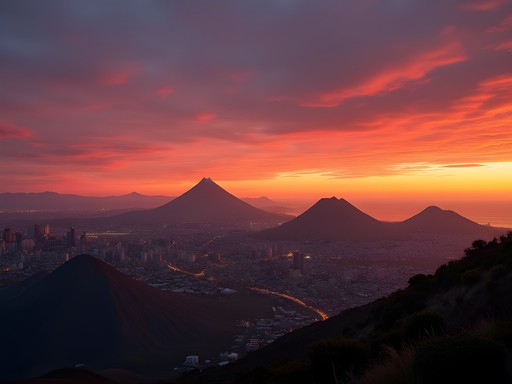
Standing atop Maungawhau/Mount Eden, I felt a peculiar scientific thrill—beneath my hiking boots lay the remnants of explosive geological forces that shaped Auckland's distinctive landscape. As both a research scientist and mindful traveler, I've found that New Zealand's largest city offers a rare urban phenomenon: 53 volcanic cones and craters scattered throughout its metropolitan area, each with its own geological story and cultural significance to Māori people. This summer, I dedicated a week to methodically exploring these ancient formations, combining physical adventure with scientific discovery in a way that's remarkably accessible for families.

Understanding Auckland's Volcanic Field: A Scientific Perspective
Before lacing up your hiking boots, it's worth understanding the remarkable geological system you're about to explore. Auckland's volcanic field spans approximately 360 square kilometers, with its oldest volcano dating back 250,000 years and the youngest—Rangitoto Island—emerging just 600 years ago. Unlike traditional volcanoes that erupt repeatedly from a single vent, Auckland's field features monogenetic volcanoes—each eruption occurs at a new location, creating the distinctive pattern of cones across the city.
As a scientist, I appreciate how this geological phenomenon creates a natural laboratory for understanding volcanic processes. Each cone represents a single eruptive event, allowing researchers (and curious travelers) to compare different eruption styles and outcomes across the field. I found my volcanic field guidebook indispensable for understanding these formations—it provides accessible scientific explanations alongside Māori cultural perspectives, which view these peaks as sacred ancestral mountains.
What fascinates me most is how these volcanoes continue to shape Auckland's development. The scoria (volcanic rock) from these eruptions has been used in construction throughout the city, while the fertile volcanic soils have supported agriculture since Māori settlement. It's a perfect example of how geological processes directly influence human habitation patterns—something I often discuss in my research on environmental adaptation.

💡 Pro Tips
- Download the Auckland Volcanic Field app for interactive maps and scientific information about each volcano
- Visit Auckland Museum's volcanic display before hiking for helpful context about formation processes
- Bring a geological compass if you have one—it's fascinating to track the magnetic variations around these volcanic sites
Maungawhau/Mount Eden: The Perfect Starting Point
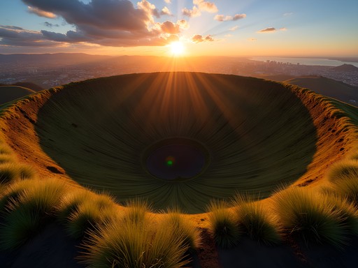
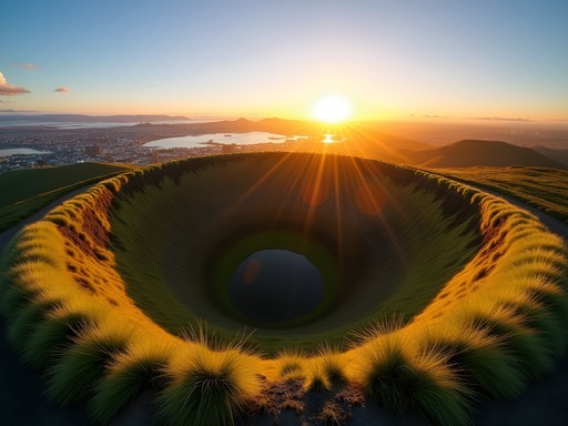
At 196 meters tall, Maungawhau (Mount Eden) offers the highest natural vantage point in Auckland and serves as an ideal introduction to the volcanic field. I began my explorations here, arriving early one morning when the crowds were thin and the light perfect for photography. The 50-meter deep crater—perfectly preserved and carpeted in grass—provides a textbook example of volcanic morphology that even my non-scientist friends found captivating.
The 1.5-kilometer loop around the summit is manageable for most fitness levels and ages, making it family-friendly despite its designation as an intermediate hike. What elevates the experience beyond mere exercise is understanding the dual significance of this place—geologically as Auckland's oldest intact volcanic cone, and culturally as a significant pā (fortified settlement) site for Māori.
I recommend packing a geological field loupe to examine the basaltic rock samples along the path. Even children become amateur geologists when they can see the crystalline structures up close! My research background had me spending nearly an hour examining different rock formations, but families might prefer the 30-minute interpretive trail that highlights both natural and cultural features.
From the summit, I used my compact monocular to identify other volcanic cones across the cityscape—the 360-degree panorama allows you to comprehend the scale of this volcanic field in a way that maps simply cannot convey.

💡 Pro Tips
- Visit at sunrise for the best photography opportunities and fewer crowds
- Look for the remains of food storage pits and terraced gardens that showcase how Māori utilized the volcanic landscape
- Bring water and sun protection as the exposed summit offers little shade
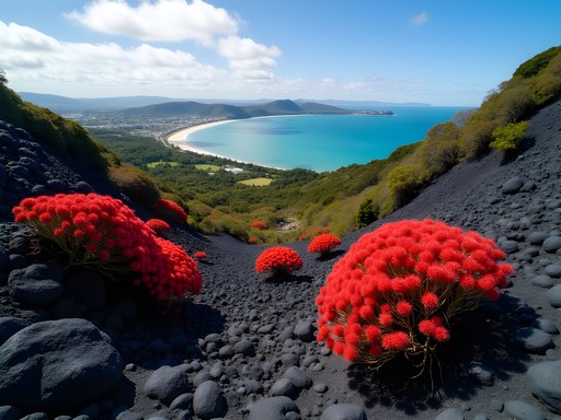
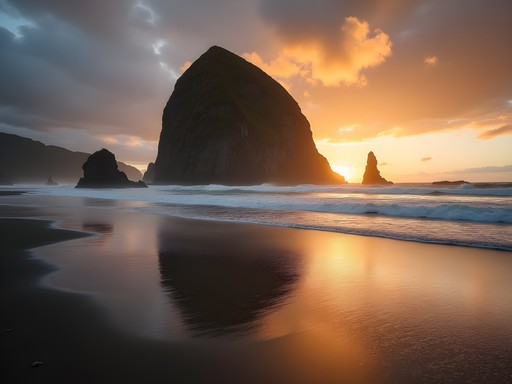
Rangitoto Island: Auckland's Youngest Volcano
No volcanic exploration of Auckland would be complete without visiting Rangitoto Island, the region's youngest and largest volcanic feature. Rising dramatically from the Hauraki Gulf just 5.5 km from downtown Auckland, this symmetrical shield volcano emerged from the sea approximately 600 years ago—recent enough that Māori oral traditions record its fiery birth.
Reaching Rangitoto requires a 25-minute ferry ride from downtown Auckland, which offers spectacular views of the city's skyline against its volcanic backdrop. I recommend booking tickets in advance during summer months when ferries can fill quickly with day-trippers.
The summit track (2.4 km each way) presents a moderate challenge, traversing fascinating lava fields before climbing through the world's largest pohutukawa forest—a remarkable example of ecological succession on new volcanic terrain. The black scoria path can be uneven and hot during summer afternoons, so proper footwear is essential. My hiking boots provided excellent traction on the sometimes loose volcanic surface.
From a scientific perspective, what makes Rangitoto exceptional is how clearly it demonstrates various volcanic features: lava tubes, scoria cones, aa and pahoehoe lava flows all within a compact area. I spent nearly 30 minutes exploring the lava caves along the summit track—a highlight for families with older children who don't mind ducking through narrow passages. Remember to bring a headlamp if you plan to explore these fascinating geological formations.
As a mindfulness practitioner, I found Rangitoto particularly conducive to contemplative hiking. The contrast between black volcanic rock and vibrant plant life creates a natural meditation on resilience and transformation—themes I often incorporate into my research on psychological responses to natural environments.

💡 Pro Tips
- Bring sufficient water (at least 2 liters per person) as there are no water sources on the island
- Pack lunch and snacks in a leak-proof container to avoid plastic waste on this pristine conservation area
- Allow 5-6 hours for the full island experience including summit hike and lava cave exploration

Family-Friendly Volcanic Adventures: Mindful Exploration with Children
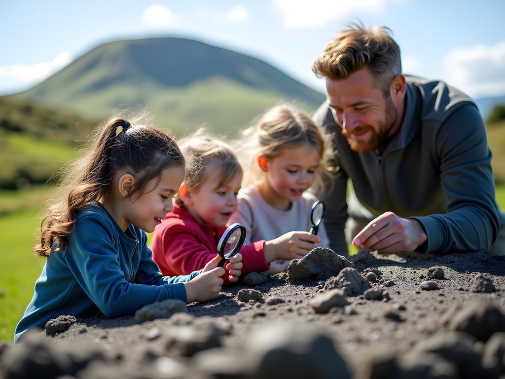
While my Auckland volcanic field exploration was primarily solo, I've designed similar scientific adventures for friends with children on previous trips. The key to engaging younger minds in geological discovery is balancing factual information with sensory experiences—something I've applied from my sports psychology research on maintaining focus and curiosity.
One-Tree Hill (Maungakiekie) offers an excellent family-friendly volcanic experience with its gentler slopes and adjacent Cornwall Park. The working farm within the park provides an opportunity to discuss how volcanic soil supports agriculture—a practical science lesson disguised as a day out. Children particularly enjoy the volcano experiment kit that I often gift to my friends' kids before such trips, creating a hands-on connection to what they're seeing in the landscape.
For families with younger children, I recommend the Otuataua Stonefields in South Auckland. This less-visited volcanic site combines geological features with archaeological remains of early Māori and European stone structures. The relatively flat terrain makes it accessible for all ages while still providing fascinating volcanic features to explore. The children's geology toolkit comes in handy here, allowing kids to collect and identify different volcanic specimens.
Incorporating mindfulness practices has proven especially effective when exploring with children. Simple exercises like a "volcanic senses scavenger hunt"—finding five things they can see, four they can touch, three they can hear, two they can smell, and one they can taste (a snack with local ingredients)—helps maintain engagement while developing observational skills essential to scientific thinking.
💡 Pro Tips
- Create a volcanic scavenger hunt list for children with items like 'pumice that floats' or 'lava rock with visible air bubbles'
- Pack a magnifying glass for each child to examine volcanic rocks up close
- Schedule hikes during cooler morning hours when children have more energy and volcanic viewpoints have better visibility
Capturing Auckland's Volcanic Beauty: Photography and Mindful Documentation
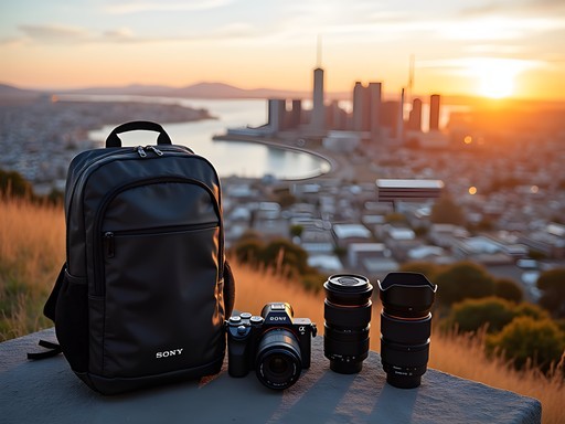
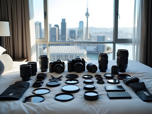
As someone who began travel blogging through scientific documentation, I've developed a methodical approach to capturing Auckland's volcanic landscapes that balances technical quality with emotional resonance. The unique lighting conditions created by Auckland's maritime climate—often featuring dramatic cloud formations against volcanic silhouettes—present both challenges and opportunities for compelling photography.
I found dawn and dusk particularly magical for photographing the volcanic cones. The low-angle light accentuates the textural details of crater rims and lava fields while adding emotional depth through color. My polarizing filter proved invaluable for managing the strong contrasts between sky and volcanic rock, especially when shooting Rangitoto from across the harbor.
For those interested in videography, Auckland's volcanic field offers excellent opportunities for time-lapse sequences showing cloud movements across the craters. I set up my portable tripod at various points around Mount Eden to capture the changing light conditions throughout the day—a technique that reveals the dynamic relationship between Auckland's weather systems and its volcanic topography.
Beyond technical considerations, I approach photography as a mindfulness practice—a way of seeing deeply into the landscape's geological and cultural layers. Before pressing the shutter, I often take a moment to consider what story each volcanic feature tells, from the violent eruptions that formed these landscapes to their sacred significance for Māori and their contemporary role in defining Auckland's urban character.
This mindful approach to documentation has enhanced my scientific observation skills while creating more meaningful visual narratives. I encourage fellow travelers to occasionally put down their cameras and simply observe—the mental images formed through full sensory engagement often inform more compelling photographs when you do pick up the camera again.

💡 Pro Tips
- Use the GeoTime Walk app to add accurate geological timestamps to your volcanic photography
- Experiment with panoramic formats to capture the relationship between multiple volcanic cones across the city
- Include human elements in some shots to convey scale—the massive craters can appear deceptively small in photographs
Final Thoughts
Auckland's volcanic field offers a rare convergence of scientific wonder, cultural significance, and accessible outdoor adventure. As both a research scientist and mindful traveler, I've found these ancient formations provide a perfect laboratory for exploring how geological processes shape human experience across generations. The methodical exploration of these volcanic sites—from the perfect crater of Maungawhau to the youthful lava fields of Rangitoto—has deepened my appreciation for the dynamic forces that continue to shape our planet.
What makes Auckland's volcanic landscape particularly special is its accessibility. Few cities worldwide offer such intimate contact with volcanic features within their urban boundaries. This proximity creates unique opportunities for families to engage with earth science concepts through direct experience rather than abstract learning.
As you plan your own volcanic adventures in Auckland, I encourage you to approach these landscapes with both scientific curiosity and cultural respect. The volcanic cones are not merely geological formations but wahi tapu (sacred places) for Māori, representing ancestral connections to the land. This dual perspective—understanding both the scientific processes and cultural significance—creates a richer, more meaningful travel experience.
I'd love to hear about your own explorations of Auckland's volcanic field. Which cones captured your imagination? What scientific discoveries surprised you? Share your experiences in the comments below, or tag me in your volcanic adventure photos on social media.
✨ Key Takeaways
- Auckland's volcanic field contains 53 distinct volcanoes that tell the geological story of the region over 250,000 years
- Combining scientific observation with cultural understanding creates more meaningful travel experiences
- Even within an urban environment, these volcanic sites offer opportunities for genuine wilderness connection and family education
- Mindful exploration techniques enhance both the educational value and personal enjoyment of geological sites
📋 Practical Information
Best Time to Visit
Summer (December-February) for optimal hiking conditions and clearest views
Budget Estimate
$1,500-$2,500 for a week-long trip including accommodations, transportation, and activities
Recommended Duration
5-7 days to explore the major volcanic sites thoroughly
Difficulty Level
Moderate - Most Hikes Require Reasonable Fitness But Are Accessible To Families With Children 8+
Comments
AdventureDad
Don't miss the Stardome Observatory on One Tree Hill/Maungakiekie if you're into astronomy! Great combo of volcanic views and stargazing.
happyway
Oh we missed that! Definitely adding it to our list for next time.
KiwiExplorer
Love this post! As an Auckland local, it's always great seeing visitors appreciate our volcanic landscape!
HikerMom44
Going to Auckland with my 6-year-old next month. Which volcano would you recommend for a child that age? Is Rangitoto too challenging?
Violet Perry
For a 6-year-old, I'd suggest starting with Maungawhau/Mount Eden - it's much shorter and still has that amazing crater view! Rangitoto is doable but it's a full day commitment with the ferry and 2+ hour return hike. North Head in Devonport is also great for kids - old military tunnels to explore plus volcanic history!
HikerMom44
Thanks so much! Mount Eden sounds perfect for us to start with.
Marco Flores
Your post brought back amazing memories, Violet! I spent a week exploring Auckland's volcanoes last year. One tip for anyone planning to visit - the Tupuna Maunga Authority has been increasing protection of these sacred sites, so some vehicle access has changed. I'd recommend checking their latest guidelines before visiting. For Maungawhau/Mount Eden, I actually found the sunrise hike to be magical - fewer people and the light hitting the crater creates this otherworldly glow. I used my hiking poles for the steeper sections of Rangitoto and they were lifesavers!
TravelBug92
Great tip about the sunrise hike! Is it safe to go up that early? And how did you get there - taxi?
Marco Flores
Totally safe! I used Uber to get there around 5:30am and there were already a few photographers setting up. The path is well-marked even in low light. Just bring a headlamp for the darker sections.
adventurevibes
Going to Auckland next month! How's the weather for hiking in November? Should I be worried about rain?
wildqueen
November is great! Spring weather, not too hot. Pack a light rain jacket just in case - Auckland weather can change quickly!
happyway
Just got back from Auckland last month and hiking Rangitoto was definitely the highlight! That view from the summit is absolutely worth the climb. We took the ferry from downtown like you suggested, Violet, but we didn't realize how exposed the trail would be - definitely bring more water than you think you need! The lava caves were such a cool surprise too. My kids (8 and 10) managed the hike just fine with plenty of breaks.
Violet Perry
So glad you enjoyed Rangitoto! Those lava caves are magical, aren't they? And great job to your kids for making it to the top!
happyway
They're still talking about it! The youngest one keeps saying he climbed a 'real volcano' haha
vacationexplorer
Just did Mount Eden yesterday based on your recommendation. Those views are incredible!
Marco Flores
If you're planning to visit multiple volcanic sites, don't miss North Head in Devonport! Not technically part of the same volcanic field, but the military tunnels combined with volcanic geography make for an incredible experience. We packed a picnic and watched the sunset over the Auckland skyline from there - absolute magic! Also, the ferry ride from downtown Auckland to Devonport is a cheap way to get amazing harbor views without splurging on a harbor cruise.
redtime
How difficult is the Rangitoto hike with kids? My daughter is 8 and loves volcanoes but I'm worried about the terrain.
Violet Perry
It's actually quite manageable for an 8-year-old volcano enthusiast! The main summit track is well-formed and gradually slopes upward. Just bring plenty of water, sun protection, and sturdy shoes as the volcanic rock can be uneven in places. The whole round trip is about 7km but you can take it slow with plenty of breaks.
Casey Andersson
As a Wellingtonian, I'm almost embarrassed to admit I only properly explored Auckland's volcanoes last month! The Māori cultural significance of these sites really adds another dimension to the experience. For anyone visiting with kids, I found the suggested family trail at Maungawhau/Mount Eden perfect - my 7-year-old nephew was engaged the whole time with the activity sheets from the visitor center. For serious hikers, I'd recommend getting the Auckland Volcanic Field Guide which has detailed maps and geological info beyond what you'll find online. Violet, your section on the pohutukawa forests on Rangitoto brought back wonderful memories!
Venture X
Premium card with 2X miles, $300 travel credit, Priority Pass