


Disclosure: This article contains affiliate links. We may earn a commission from purchases at no extra cost to you, which helps our travel content.
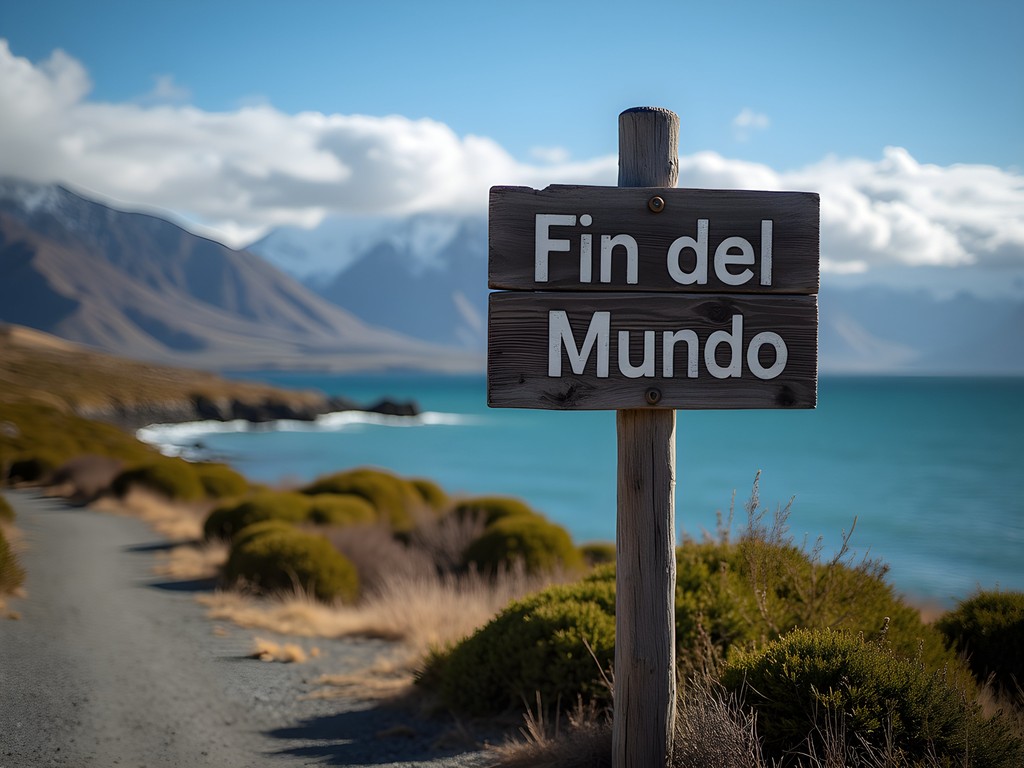
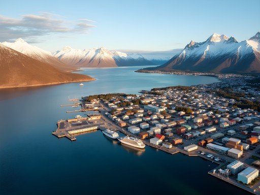
Standing at the edge of Ushuaia, with the Beagle Channel stretching before me and the rugged peaks of Tierra del Fuego rising behind, I couldn't help but feel I'd reached a profound frontier. They call this place 'El Fin del Mundo' – the End of the World – and the name resonates with a truth that settles deep in your bones. As someone who's hiked across deserts and traversed countless bridges connecting communities, I found something uniquely humbling about exploring the southernmost city on Earth. While my usual adventures involve my two children exploring alongside me, this solo journey to Argentina's edge became a reconnection with the parts of myself that exist beyond motherhood. Over seven unforgettable days, I discovered trails that challenged my body, expanded my mind, and reminded me why wilderness preservation matters so deeply to the future we're creating for our children.

Preparing for Patagonia: What You Really Need to Know
Let me start with something crucial that many guides overlook: Ushuaia's weather patterns defy expectations even in summer. During my January visit—peak summer in the Southern Hemisphere—I experienced four seasons in a single day, sometimes within a single hour. This isn't hyperbole; it's the reality of hiking at the end of the world.
The region's proximity to Antarctica creates weather systems that shift with startling speed. One moment you're peeling off layers under bright sunshine; the next, you're facing sideways rain and wind that nearly knocks you off your feet. This unpredictability demands serious preparation.
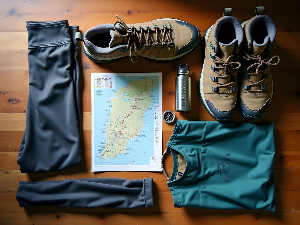
Before arriving, I spent considerable time researching appropriate gear. My waterproof hiking boots proved indispensable across every trail I tackled. The ankle support prevented injuries on rocky descents, while the waterproofing kept my feet dry through stream crossings and unexpected rain showers.
Equally important was my layering system. Rather than one heavy jacket, I relied on multiple adaptable layers. My base consisted of moisture-wicking merino wool, topped with a fleece mid-layer, and finished with a waterproof shell jacket that proved worth every penny when facing Patagonian winds.
For navigation, while many trails are well-marked, cell service is spotty at best. I downloaded offline maps through AllTrails Pro and carried a physical map as backup. The combination provided security without adding significant weight to my pack.
💡 Pro Tips
- Pack for all four seasons regardless of when you visit
- Invest in quality waterproof boots with ankle support
- Download offline maps before heading out on any trail
Trail #1: Glaciar Martial - The Perfect Acclimatization Hike
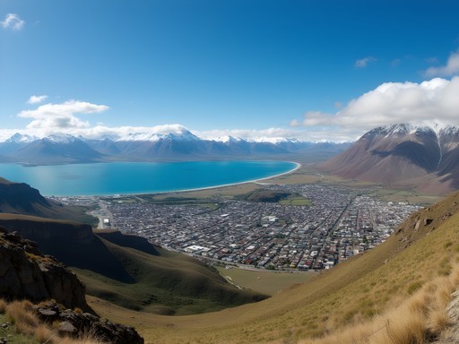
Just a short taxi ride from downtown Ushuaia sits Glaciar Martial, what I consider the ideal first hike for visitors. This trail offers the perfect introduction to Fuegian landscapes without requiring technical skills or exceptional fitness.
The trail begins at the base of an old ski lift (which operates during summer months for those wanting to shorten the ascent). Having arrived the previous day from sea level Philadelphia, I opted to hike the entire route to help my body adjust to the elevation change gradually.
The initial section winds through a lenga forest, where the twisted, wind-sculpted trees tell silent stories of survival in one of Earth's harshest environments. The forest eventually gives way to alpine meadows dotted with hardy wildflowers that somehow thrive in this unforgiving climate.
The final ascent becomes steeper as you approach the glacier, with some sections requiring careful footing on loose rock. While not technically difficult, the combination of elevation and unpredictable weather makes this more challenging than the distance might suggest.
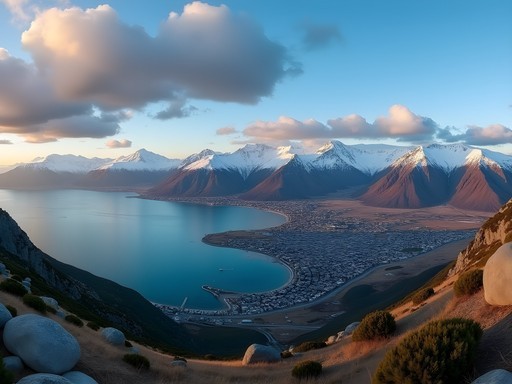
Reaching the glacier viewpoint rewards you with a panorama that literally took my breath away—Ushuaia spread below, the Beagle Channel stretching toward the horizon, and distant Chilean islands creating a layered landscape that photographs simply cannot capture.
What makes this trail particularly valuable is its accessibility. At just 7.5 km (4.7 miles) round trip with 650m (2,130ft) of elevation gain, it can be completed in 3-4 hours, leaving time to return to town for a hearty meal of Fuegian lamb and local craft beer—the perfect recovery after your first Patagonian adventure.

💡 Pro Tips
- Start early to avoid afternoon crowds and have better lighting for photos
- Pack microspikes if hiking in early summer when ice may still be present near the glacier
- Consider taking the chairlift down if your knees are sensitive to descents
Trail #2: Laguna Esmeralda - Turquoise Waters and Peat Bogs
Approximately 20km east of Ushuaia lies one of Tierra del Fuego's most photogenic hikes: the trail to Laguna Esmeralda. The name—Emerald Lagoon—perfectly captures the mineral-rich turquoise waters that await at the trail's end, but the journey itself offers ecological lessons I found fascinating as both a traveler and a mother who values environmental education.
The trailhead begins off Route 3, where several tour operators drop hikers throughout the day. As someone who values independence, I arranged a morning drop-off with a scheduled late afternoon pickup, giving me ample time to explore at my own pace—a luxury not afforded by guided tours.
What makes this trail unique is the terrain variety packed into its relatively modest 9km (5.6 miles) round-trip distance. The path crosses through dense southern beech forests before opening into vast peat bogs that require careful navigation. These bogs—called turbales locally—are ecologically significant carbon sinks that have developed over thousands of years.
Traversing the bogs requires stepping on strategically placed logs or finding the slightly firmer ground between soggy sections. My trekking poles proved invaluable here, providing stability and helping test ground firmness before committing my weight.
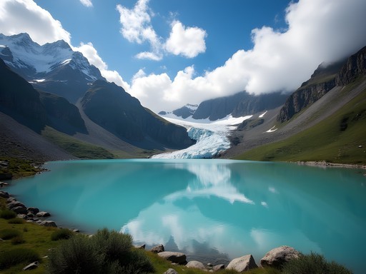
The final approach reveals the lagoon gradually, with each step bringing more of its stunning color into view. The emerald waters derive their color from minerals carried down from the surrounding mountains and glacier. Speaking of which, the Ojo del Albino Glacier feeds the lagoon from above, creating a perfect backdrop for photographs.
I spent nearly an hour at the lagoon's edge, watching light play across the water's surface while enjoying the lunch I'd packed. The silence was profound—interrupted only by occasional ice creaks from the distant glacier and the soft whisper of wind through lenga trees.

💡 Pro Tips
- Wear waterproof footwear as bog crossings are unavoidable
- Pack a change of socks in case your feet get wet in the peat bogs
- Allow extra time for photography—the changing light creates dramatically different views of the lagoon

Trail #3: Tierra del Fuego National Park - Coastal Path
If there's one trail that captures the essence of Tierra del Fuego's unique position at the convergence of mountains, forest, and sea, it's the Coastal Path (Senda Costera) within Tierra del Fuego National Park. This 8km (5 mile) trail connects Ensenada Bay to Lapataia Bay, following the shoreline of the Beagle Channel through landscapes that feel untouched by time.
Accessing the park requires either booking a shuttle from Ushuaia or taking the End of the World Train (Tren del Fin del Mundo)—a historic narrow-gauge railway once used by prisoners to harvest timber. While more expensive than the shuttle, the train offers historical context that enriched my understanding of the region's complex past.
The trail itself is relatively flat compared to others in the region, making it accessible to hikers of various fitness levels. What it lacks in elevation challenge, it more than compensates for in biological diversity. Walking this path is like traversing multiple ecosystems in miniature.
I began at Ensenada Bay, where the morning light illuminated the Chilean islands across the channel. The path initially winds through wind-stunted forests where trees grow in curious shapes—bent and twisted by centuries of relentless Patagonian winds. These forests harbor a surprising diversity of birdlife; I spotted Magellanic woodpeckers, austral parakeets, and even a Chilean hawk during my hike.
Approaching Lapataia Bay, the landscape opens to reveal beaver dams and the environmental impact these introduced species have had on the native ecosystem. As a public defender who often contemplates how systems impact individuals, I found myself reflecting on how human interventions—like introducing beavers in the 1940s—can create cascading consequences across generations.
The trail culminates at Lapataia Bay, where a simple sign marks the official end of the Pan-American Highway—quite literally the end of the road in the Americas. Standing there, looking south toward Antarctica with no more continental land masses between us, I experienced a profound sense of having reached a genuine frontier. I captured this moment with my compact camera, which proved perfect for documenting wildlife and landscapes without the bulk of a DSLR.
💡 Pro Tips
- Book the first morning train or shuttle to enjoy sections of the trail before other hikers arrive
- Pack binoculars for spotting marine wildlife along the Beagle Channel
- Visit the park office for a detailed map showing viewpoints and wildlife observation areas
Trail #4: Cerro Guanaco - The Challenging Summit
For those seeking a genuine physical challenge with proportionately spectacular rewards, Cerro Guanaco stands as Ushuaia's premier day hike. At 970 meters (3,182 feet), this peak within Tierra del Fuego National Park offers what many consider the most comprehensive views in the region—but reaching them requires determination and proper preparation.
The trail begins innocuously enough near Lake Roca, with a gentle forest path that lulls you into a false sense of security. This pleasant introduction quickly gives way to increasingly steep terrain that had me questioning my fitness level despite regular training hikes back home. The middle section traverses through lenga forests where the canopy occasionally opens to provide motivating glimpses of the view to come.
It's the final third of the ascent that truly tests your resolve. The trail emerges above the treeline into an alpine environment where exposure to Patagonian weather becomes a significant factor. During my climb, what began as a clear morning transformed into swirling mist and wind gusts strong enough to require a wide stance for stability.
The trail's steepness combines with loose scree in sections, making proper footwear essential. My trekking poles again proved invaluable, particularly during the descent when tired legs appreciate the additional support.
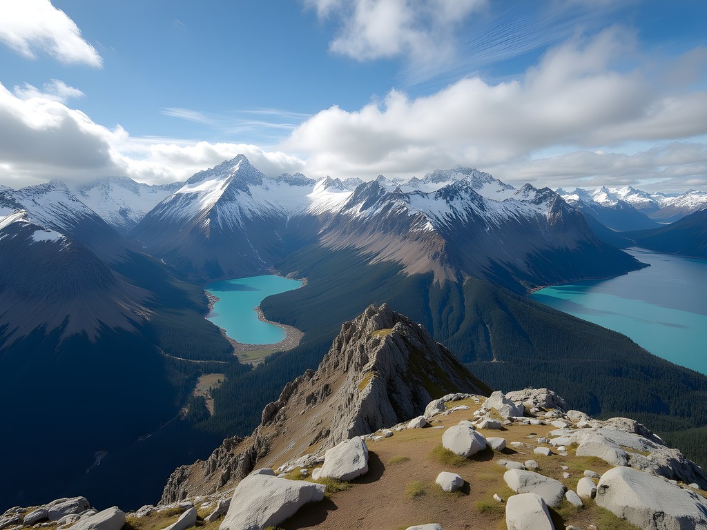
Reaching the summit plateau delivers an almost spiritual reward—a 360-degree panorama encompassing the Beagle Channel, Ushuaia, Lake Fagnano to the north, and on clear days, views extending into Chile. The perspective fundamentally changes how you understand the geography of Tierra del Fuego, revealing how this archipelago truly sits at the convergence of mountain and sea.
I spent nearly an hour at the summit despite the wind, finding shelter behind a rock formation to enjoy the packed lunch I'd prepared. My insulated water bottle kept my tea perfectly hot—a small luxury that felt enormous in that remote setting. The warmth spreading through my chest mirrored the sense of accomplishment I felt gazing out over landscapes few travelers ever witness.
💡 Pro Tips
- Start no later than 9am to ensure enough time for a safe descent
- Pack extra warm layers even in summer—the summit is significantly colder and windier than the trailhead
- Consider using a GPS app with the route downloaded, as fog can make trail finding difficult near the summit
Trail #5: Glacier Vinciguerra and Laguna de los Témpanos - The Hidden Gem
While the previous trails appear in most guidebooks, my final recommendation comes from a local park ranger I befriended over mate tea at a café in Ushuaia. When I asked about less-traveled paths that still offered spectacular scenery, he didn't hesitate: "Vinciguerra Glacier and Laguna de los Témpanos—it's where I take my family, not tourists."
Located just 7km from Ushuaia, this trail sees a fraction of the visitors that flock to more famous routes, yet offers an experience that rivals or exceeds them all. The trailhead begins at the end of a dirt road in the Andorra Valley, an area that feels distinctly more lived-in than other starting points, with small farms and local residences dotting the landscape.
The initial path crosses through a working forest where sustainable logging practices are demonstrated through interpretive signs—a fascinating glimpse into how communities here balance economic needs with environmental preservation. This educational component reminded me of the smart-city initiatives I've studied on tribal lands back home, where traditional knowledge informs modern sustainability practices.
Beyond the forest, the trail climbs steadily through high meadows carpeted with tiny alpine flowers that somehow survive in this harsh climate. Their resilience struck me as a powerful metaphor for the human communities that have made this remote corner of the world their home.
The final approach to the glacier involves some light scrambling over moraine fields—areas where rocks and debris have been deposited by the glacier's historical retreat. This section requires careful attention to footing but presents no technical challenges for experienced hikers.
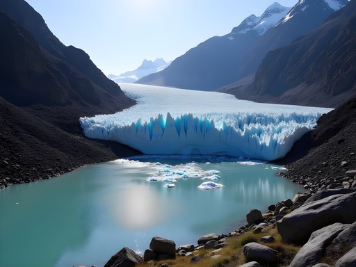
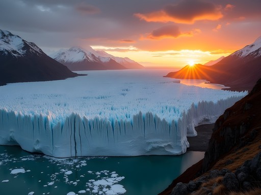
The payoff is extraordinary: Laguna de los Témpanos (Iceberg Lagoon) sits in a natural amphitheater with the Vinciguerra Glacier descending dramatically to the water's edge. During my visit, small icebergs that had calved from the glacier floated serenely in the intensely blue water.
What makes this experience special beyond the scenery is the solitude. While other popular trails might see hundreds of hikers daily in peak season, I encountered only two other small groups during my entire day on this trail. This allowed for moments of genuine connection with the landscape—sitting in silence, listening to the occasional crack and rumble of the glacier, and reflecting on the profound age of the ice before me.

💡 Pro Tips
- Register your hike with park authorities as this trail has less traffic if emergency assistance is needed
- Bring a water filter as streams along the route provide fresh drinking water
- Pack a lightweight sit pad for comfortable rest stops on rocky terrain near the glacier
Final Thoughts
As my week in Ushuaia drew to a close, I found myself standing at the harbor watching ships prepare for Antarctic expeditions, reflecting on what makes hiking at the end of the world so profoundly moving. It's not just the breathtaking landscapes or the physical challenge—it's the perspective that comes from exploring a place where human presence feels both recent and tenuous. These trails reveal the delicate relationship between civilization and wilderness at Earth's extremes. Whether you're an experienced solo hiker or someone seeking to push personal boundaries, Ushuaia's trails offer something rare in our increasingly connected world: genuine frontier experiences accessible without technical mountaineering skills. Pack thoughtfully, respect the unpredictable weather, and prepare to be transformed by landscapes that have remained largely unchanged since Magellan first navigated these waters. The end of the world, I discovered, can be the beginning of a new understanding of our place on this remarkable planet.
✨ Key Takeaways
- Ushuaia's trails offer world-class hiking accessible to intermediate hikers with proper preparation
- Weather preparedness is essential regardless of season—layers and waterproofing are non-negotiable
- Less-traveled trails like Vinciguerra Glacier often provide the most memorable experiences
- Allow extra days in your itinerary for weather delays or trail closures
📋 Practical Information
Best Time to Visit
December through February (Austral summer)
Budget Estimate
$100-150 USD per day including accommodations, food and transportation
Recommended Duration
Minimum 5-7 days
Difficulty Level
Intermediate
Comments
photomate
heading there in october! did you rent a car or use tours for the trails? trying to decide what makes more sense
Megan Martin
Not Savannah, but I rented a car and it was totally worth it for the flexibility. Some trails like Laguna Esmeralda are easier to reach with your own transport. Just watch out for the gravel roads!
photomate
awesome thanks! yeah think we'll go the rental route
summerguy
Love the photos! Adding this to my bucket list
Megan Martin
Great guide, Savannah! I did Laguna Esmeralda last year and completely agree about the peat bog sections - waterproof boots are absolutely essential. One tip I'd add: start early for that trail (like 8am) because the parking area fills up fast, especially in peak season. The turquoise color of the lake is even more stunning in morning light. Did you make it to Laguna del Caminante? It's a much harder trek but the views are incredible.
Savannah Torres
Yes! Great tip about the early start. I didn't do Laguna del Caminante this time but it's on my list for next visit. Heard it's a serious full-day commitment.
happymood
this looks amazing!! quick question - what time of year did you go? trying to figure out best months for weather
Savannah Torres
I went in late March (their fall) and weather was pretty mild! Summer (Dec-Feb) is most popular but can be crowded. I'd avoid June-August unless you're into serious winter hiking.
happymood
perfect thanks!!
bluenomad
Did you make it to any of the penguin colonies while you were there? We're trying to decide between the boat tour to Isla Martillo or the catamaran to the lighthouse with sea lions. Any recommendations?
Savannah Torres
I did both actually! If you have to choose just one, I'd go with Isla Martillo - walking among the Magellanic and Gentoo penguins was unforgettable. But book early, the walking tours sell out weeks in advance in peak season!
bluenomad
Thanks! Just booked Isla Martillo. So excited!
mountainqueen
Those turquoise waters at Laguna Esmeralda are UNREAL! Your photos don't even look real 😍
Savannah Torres
Right?! And the photos honestly don't do it justice. That mineral-rich water against the mountain backdrop is something else entirely in person.
Sophia Gomez
This brings back memories! I hiked all these trails last year while researching for a travel piece. The Coastal Path in Tierra del Fuego National Park was my absolute favorite - we spotted three different fox families and countless birds. One tip I'd add: the winds in Ushuaia are no joke! I was so glad I had my windbreaker which packs small but saved me multiple times. Also, for anyone visiting, leave extra time for the Martial Glacier hike - the views kept stopping me in my tracks for photos, and I ended up watching the sunset from up there (not planned but magical!).
luckylover
What's the weather like in December? Thinking of going for Christmas!
bluenomad
I went last December! It's their summer so days are LONG (like 17 hours of daylight). Temps were around 10-15°C (50-60°F) but wind can make it feel colder. Layers are your best friend there!
exploremate
This is perfect timing! I'm heading to Ushuaia in September. How difficult would you rate the Laguna Esmeralda trail for someone with moderate hiking experience? Those peat bogs sound tricky!
Savannah Torres
The Laguna Esmeralda trail is definitely manageable with moderate experience! The peat bogs can be muddy, so waterproof hiking boots are essential. There are wooden planks over the worst sections. The trail is well-marked and the elevation gain is gradual - about 3-4 hours round trip. You'll love it!
exploremate
Thanks so much! Definitely packing my waterproof boots then. Can't wait to see that turquoise water in person!
PatagoniaLover
Your photo of the sunset over the Beagle Channel is absolutely stunning! What camera did you use?
Savannah Torres
Thank you! That was actually just shot on my phone - Google Pixel 6 Pro. The light in Patagonia does all the heavy lifting!
Venture X
Premium card with 2X miles, $300 travel credit, Priority Pass