


Disclosure: This article contains affiliate links. We may earn a commission from purchases at no extra cost to you, which helps our travel content.
There's something utterly magical about hiking along the edge of a continent, where land meets the vast expanse of ocean. Wellington—New Zealand's compact, culture-rich capital—offers precisely this magic in abundance. As an urban planner, I'm typically drawn to clever city designs and innovative public spaces, but Wellington's coastal trails reveal something equally fascinating: the delicate balance between wild nature and human habitation. Having just returned from a week exploring the city's windswept peninsulas and dramatic headlands on foot, I can confirm that these trails deliver not just stunning vistas, but a unique perspective on how a city can coexist with its natural boundaries. Pack your hiking boots, prepare for Wellington's famous winds, and join me as we explore five trails that showcase the best of New Zealand's rugged coastal beauty—all accessible on a modest budget and perfect for the solo adventurer with an intermediate fitness level.

Red Rocks Reserve: Seals, Shipwrecks, and Maori History
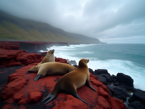
My Wellington coastal adventure began at Red Rocks Reserve (Te Kopahou), a windswept stretch of shoreline that feels worlds away from the city despite being just a 30-minute drive from the CBD. The trail starts at the Owhiro Bay car park, where I shouldered my trusty daypack and set off along the gravel road that hugs the coastline.
What makes this trail special isn't just the distinctive rust-colored rocks that give the reserve its name (formed from ancient pillow lava approximately 200 million years ago), but the remarkable wildlife encounters. Between May and October, you're likely to spot New Zealand fur seals lounging on the rocks—I counted seven during my spring visit, including a particularly large male who seemed thoroughly unimpressed by my photography attempts.
The 7km return journey takes you past the historic Sinclair Head/Te Rimurapa, where Māori once maintained a lookout point. Walking this trail, you experience the raw power of the Cook Strait, with its unpredictable weather and churning waters that have claimed numerous ships over the centuries. The remains of the SS Yung Pen shipwreck are still visible at low tide, a haunting reminder of the ocean's force.
What struck me as particularly interesting was how this coastal ecosystem has been managed. Conservation efforts have successfully balanced public access with habitat protection, a delicate dance that reminds me of similar challenges we face in urban planning. The trail itself is relatively flat and wide—perfect for intermediate hikers who want dramatic scenery without punishing elevation gains.

💡 Pro Tips
- Time your visit with low tide to see the shipwreck remains
- Bring binoculars for seal spotting and birdwatching
- Pack extra layers—Wellington's famous winds are particularly strong here
Escarpment Track: The 'Stairway to Heaven'
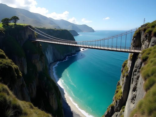
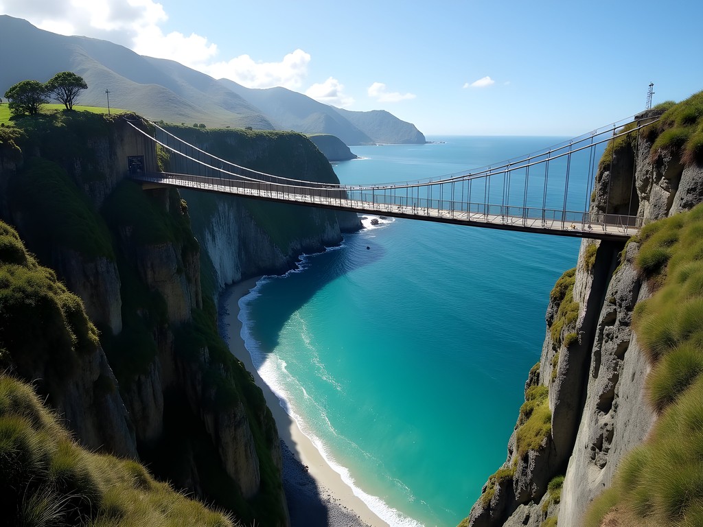
If you're seeking that perfect Instagram moment combined with a proper leg workout, the Escarpment Track between Paekakariki and Pukerua Bay is your answer. Located about 45 minutes north of Wellington by train, this 10km one-way trail has earned its nickname 'Stairway to Heaven' for good reason—you'll climb roughly 220 meters via numerous staircases cut into the hillside.
I set out early one misty spring morning, catching the first train from Wellington to Paekakariki (a wonderfully scenic journey in itself). The trail begins innocuously enough, winding through coastal scrubland before climbing steeply up the escarpment. What followed was a ridge-top adventure that had me alternating between gasping at the views and simply gasping for breath.
The trail features two swing bridges that sway disconcertingly in Wellington's ever-present winds. Crossing them with my moderate fear of heights was a personal triumph—though I confess to a white-knuckle grip on the railings. The payoff, however, is immense: panoramic views of Kapiti Island to the west and the Tasman Sea stretching endlessly toward Australia.
As an urban planner, I was fascinated by how the trail interacts with the main trunk railway line and State Highway 1 below—three transportation corridors stacked vertically in this narrow space between hills and sea. It's a brilliant example of making the most of limited coastal terrain.
My hiking poles proved invaluable on the steep sections, particularly during descent. Though I consider myself reasonably fit, my legs were certainly feeling the burn by the time I reached Pukerua Bay. From there, I caught the train back to Wellington, pleasantly exhausted and with a camera roll full of spectacular coastal vistas.
💡 Pro Tips
- Start from Paekakariki and end at Pukerua Bay for the best views
- Check train schedules in advance for your return journey
- Allow 3-4 hours for the one-way hike, depending on your photo stops
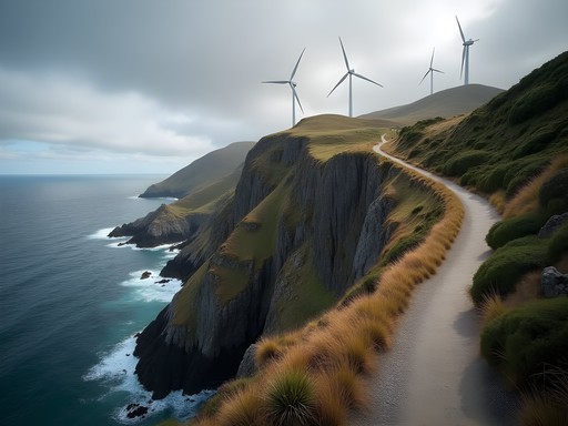
Makara Beach Walkway: Wild Western Exposure
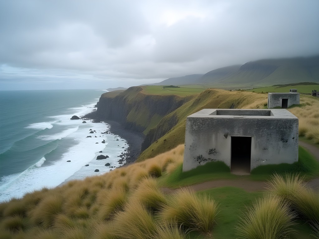
For those seeking solitude and raw, untamed coastline, the Makara Beach Walkway delivers in spades. Located on Wellington's remote western edge, this 6km loop track offers a perfect half-day adventure that showcases the region's military history alongside its natural splendor.
I arrived at Makara Beach after a winding 30-minute drive from Wellington's center. The small fishing village has a distinctly end-of-the-road feel—the perfect launching point for a wilderness experience. The trail begins with a steady climb up from the beach, quickly gaining elevation as it ascends the headland.
What makes this trail particularly fascinating is the juxtaposition of natural and historical elements. The path takes you past World War II gun emplacements that once guarded Wellington Harbor from potential invasion. Standing in these concrete remnants while gazing out at the wild Tasman Sea creates an eerie connection to the past—I couldn't help but imagine the soldiers stationed here, scanning these same horizons for enemy ships.
The exposed ridgeline section delivers the hike's signature experience: uninterrupted views across Cook Strait toward the South Island on clear days, with the wind typically blowing strong enough to nearly push you sideways. I found myself leaning into the gale at certain points, laughing at the sheer force of Wellington's famous winds.
Birdlife abounds here—I spotted several species including the distinctive white-fronted tern diving for fish. The descent back to Makara Beach offers a different perspective, winding through farmland where sheep graze seemingly oblivious to the spectacular ocean views.
After completing the loop, I treated myself to a packed lunch on the beach, watching local fishermen cast lines into the surf. My lightweight insulated jacket proved perfect for the rapidly changing conditions—warm enough when the wind picked up but not too hot during the uphill sections.
This trail perfectly embodies Wellington's character: historically significant, naturally dramatic, and always, always windy.
💡 Pro Tips
- Wear a hat with a chin strap—the wind is no joke here
- Visit on a weekday to have the trail almost entirely to yourself
- Bring your own water and snacks as there are no facilities on the trail

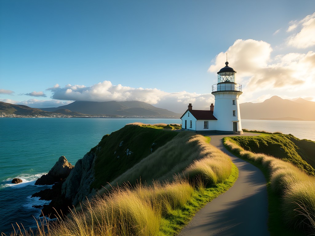
Pencarrow Coast Trail: Lighthouses and Lakes
The eastern harbor entrance of Wellington offers a completely different coastal experience from the wild west coast. The Pencarrow Coast Trail follows a relatively flat 8km service road from Eastbourne to New Zealand's first lighthouse at Pencarrow Head, making it one of the more accessible coastal walks in the region.
I began my journey by catching the East by West ferry from downtown Wellington to Days Bay, then rented a bike from the local shop to reach the trailhead at Burden's Gate. While you can walk the entire way, cycling the first portion saved valuable time (and energy).
What makes this trail special is its historical significance combined with unique ecological features. The path skirts two freshwater lakes—Kohangapiripiri and Kohangatera—that sit just meters from the saltwater harbor, separated only by a narrow gravel bar. As an urban planner, I found this natural feature fascinating—a perfect example of how coastal landscapes evolve and adapt.
The star attraction is undoubtedly the Pencarrow Lighthouse itself, New Zealand's first permanent lighthouse established in 1859. What makes its story particularly compelling is that the first lighthouse keeper was Mary Jane Bennett, a woman who took over the role after her husband drowned. Standing beside this historic structure, imagining Mary tending the light through wild Wellington storms while raising her children in isolation, I felt a profound connection to the resilience of those who came before us.
The return journey offers spectacular views across Wellington Harbor toward the city skyline—a reminder of how relatively small human settlements appear against the vastness of land and sea. I was fortunate to visit on a clear spring day when the famous Wellington winds were relatively calm, allowing for perfect photography conditions.
My polarized sunglasses proved essential here, cutting the glare from both sea and sky while enhancing the vivid colors of the landscape. The combination of historical significance, ecological diversity, and stunning harbor views makes this trail a must-do for any visitor to Wellington.
💡 Pro Tips
- Consider renting a bike to cover more ground (available in Eastbourne)
- Check ferry schedules in advance to plan your return to Wellington
- Visit the lower lighthouse first, then climb to the upper light for the best experience
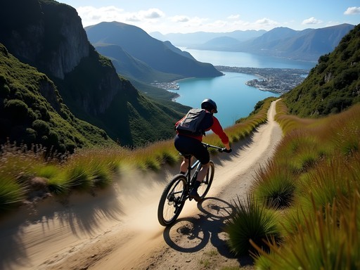
Southern Walkway: Urban to Wild in One Trail
What if you could experience both Wellington's urban charm and its wild coastline in a single hike? The Southern Walkway delivers precisely this compelling contrast, connecting the city center to the rugged south coast in a 10km point-to-point journey that showcases Wellington's remarkable geographic diversity.
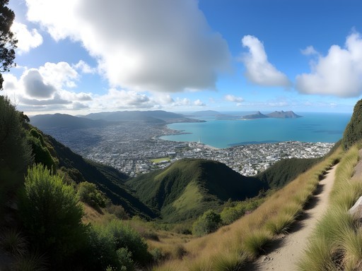
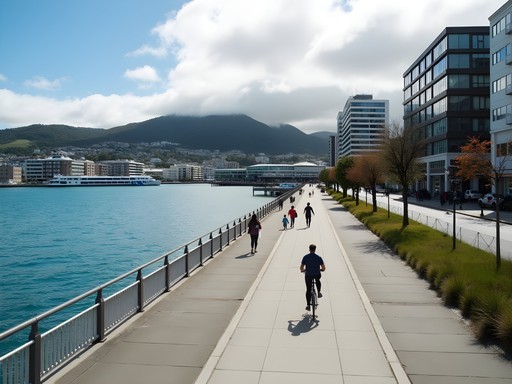
I began my adventure at Oriental Bay, Wellington's inner-city beach, where locals were enjoying their morning coffees along the promenade. The trail climbs steadily through the historic residential neighborhoods of Mt Victoria, where charming wooden villas cling to impossibly steep streets—a distinctly Wellington architectural adaptation.
Reaching the Mt Victoria Lookout provides the hike's first reward: a 360-degree panorama of the city, harbor, and surrounding mountains. As an urban planner, I was struck by how clearly you can read Wellington's development patterns from this vantage point—the city's growth constrained and shaped by its dramatic topography.
Continuing south, the trail traverses the Town Belt, a green corridor that has protected Wellington from urban sprawl since the city's founding. This forward-thinking 19th-century planning decision has given modern Wellington residents access to nature within minutes of the central business district—something many cities worldwide now strive to create.
The middle section of the walkway passes through regenerating native bush, where I spotted tui birds feeding on flax flowers and heard the distinctive call of the bellbird. The gradual transition from urban to natural environments is seamless and beautifully managed.
As the trail approaches Island Bay, coastal views begin to dominate. The final descent to the south coast offers spectacular vistas across Cook Strait toward the South Island, with Taputeranga Marine Reserve's protected waters directly offshore.
I finished my journey at Island Bay, where the local fish and chip shop provided a well-earned reward. From here, regular buses return to the city center, making this a logistically simple one-way hike.
My trail running shoes were the perfect footwear choice for this varied terrain—grippy enough for the occasional muddy section but comfortable on the paved portions as well. The Southern Walkway perfectly encapsulates Wellington's unique charm: a capital city where wilderness is never more than a short walk away.

💡 Pro Tips
- Start early to enjoy Mt Victoria lookout before the crowds arrive
- Download the Wellington City Council trail map before setting out
- Pack both urban and wilderness essentials—you'll experience both environments
Final Thoughts
Wellington's coastal trails offer something truly special: the rare opportunity to experience wild, dramatic shorelines within easy reach of a vibrant capital city. As someone who studies urban environments professionally, I'm endlessly fascinated by this juxtaposition—how the compact city gives way to untamed coastline in just a few kilometers. These five trails showcase the best of Wellington's coastal diversity, from the seal colonies of Red Rocks to the historic lighthouses of Pencarrow Head. What makes these hikes particularly appealing for solo travelers is their accessibility, safety, and the ease of using public transport to reach most trailheads. Whether you have just a day or a full week to explore, Wellington's coastal paths provide the perfect blend of physical challenge, natural beauty, and cultural connection. Pack your hiking boots, prepare for every type of weather (often in the same day), and discover why Wellington's wild edges might just be New Zealand's most underrated hiking destination.
✨ Key Takeaways
- Wellington offers accessible coastal hiking suitable for intermediate fitness levels
- Public transportation makes most trails logistically simple, even for one-way hikes
- Spring brings optimal hiking conditions with fewer crowds and moderate temperatures
📋 Practical Information
Best Time to Visit
Spring (September-November) or Autumn (March-May)
Budget Estimate
$500-700 NZD for a week (accommodation, food, transportation)
Recommended Duration
5-7 days
Difficulty Level
Intermediate


Comments
weather_watcher
Just a heads up for anyone planning these hikes - check the weather forecast carefully. Wellington can have four seasons in one day! We got caught in a sudden downpour on the Pencarrow trail and it was pretty miserable for a while.
Douglas Bradley
Great point about the weather! I always carry a packable rain jacket in Wellington, even on sunny days. The forecasts can be notoriously unreliable when it comes to those quick weather changes.
solo_wanderer
Those photos are stunning! Adding Wellington to my bucket list right now!
travel_with_kids
Great post! Would any of these trails be suitable for kids (ages 7 and 10)? They're good hikers but I'm worried about some of the steeper sections mentioned.
citybuddy4313
Red Rocks is perfect for kids! It's mostly flat and they'll love seeing the seals. Makara Beach walkway might work too, but I'd skip Escarpment with younger kids - those stairs and narrow sections can be a bit much.
travel_with_kids
Thanks so much! Red Rocks it is then. Can't wait to show the kids those seals!
Douglas Bradley
Jean, this is an excellent guide to Wellington's coastal trails! I visited last year and did both the Red Rocks Reserve and Pencarrow Coast trails. What struck me most was the incredible biodiversity - from the seal colony at Red Rocks to the various seabirds along Pencarrow. The historical elements of these trails add such rich context to the hikes. One tip for others: Wellington's famous winds are no joke - I'd recommend bringing a windproof jacket or similar, especially for the more exposed sections. The Pencarrow lighthouse history is fascinating - did you get a chance to learn about Mary Jane Bennett, New Zealand's first female lighthouse keeper?
hiking_enthusiast
Those Wellington winds are legendary! I got nearly blown off the trail at Makara Beach last month. Definitely second the windproof jacket recommendation.
kiwi_explorer
Red Rocks is amazing! We saw about 20 seals when we went in November. Best time to visit is definitely winter months for seal spotting.
citybuddy4313
Just got back from doing the Escarpment Track last week and WOW those stairs are no joke! The locals call it 'Stairway to Heaven' for good reason. My legs were burning but those ocean views were worth every step. We got lucky with clear weather but it got super windy at the top. If anyone's planning to do this one, start early in the morning before the wind picks up!
Douglas Bradley
How long did it take you to complete the track? I'm planning to include it in my Wellington itinerary but trying to figure out timing.
citybuddy4313
It took us about 3.5 hours including stops for photos and snacks. Definitely allow 4+ hours if you want to really enjoy it without rushing!
Douglas Bradley
Perfect, thanks for the info! Did you take public transport or drive there?
citybuddy4313
We did the train + short walk option. Super easy and you don't have to worry about parking or doing a car shuttle!
exploreadventurer
Bus from the city center works great for most of these. Way easier than dealing with parking.
wildgal
Your photos are gorgeous! Added to my bucket list 🌊
Marco Flores
Beautiful post! I spent a week exploring these trails last winter and fell in love with the raw, untamed feeling of Wellington's coast. Pencarrow was my favorite - cycling out to the lighthouse with the wind pushing you along, then that brutal ride back against it. The lakes are such a surprise in that landscape. I camped nearby and watched the sunrise over the water. One thing I'd add: check the tide times for Red Rocks. Some sections are much easier at low tide, and you get better seal viewing too.
winterbackpacker9328
Going to Wellington in March!! Is the weather okay for these hikes then?
exploreadventurer
March is good but bring layers. Wellington wind is real!
Nicole Russell
Jean, this post is SO good!! I did the Escarpment Track solo last month and wow, that 'Stairway to Heaven' name is no joke 😅 My legs were screaming but the views at the top were absolutely worth every step. The city on one side, the wild coast on the other - just stunning! I stayed at a hostel in Mount Victoria and caught the bus out there super early. The morning light on the ocean was magical. Can't wait to go back and tackle Makara Beach next time!
Marco Flores
The morning light makes all the difference! Did you see any of the WWII bunkers up there?
Nicole Russell
Yes! They were so cool to explore. A bit eerie but really fascinating.
Venture X
Premium card with 2X miles, $300 travel credit, Priority Pass