


Disclosure: This article contains affiliate links. We may earn a commission from purchases at no extra cost to you, which helps our travel content.
Standing at the Pike Place Market viewpoint, watching ferries glide across Puget Sound while the distant Olympic Mountains catch the last light of day, I'm reminded why Seattle holds such a special place in my heart. As someone who regularly shuttles between tech hubs in Chennai and the Pacific Northwest, I've perfected the art of experiencing this rain-kissed city without ever reaching for rental car keys. There's something profoundly liberating about navigating urban spaces using only your feet and public transportation—a mindfulness practice that connects you more intimately with a city's rhythm and soul. Whether you're visiting for business or pleasure, Seattle's comprehensive transit network offers an accessible, affordable, and surprisingly spiritual way to experience the Emerald City's many wonders. Join me as I share how to make the most of a car-free Seattle adventure, drawing from years of personal exploration and the quiet wisdom that comes from slowing down in one of America's most vibrant urban landscapes.

Understanding Seattle's Transit Network: Your Car-Free Foundation
Seattle's public transportation system initially appears modest compared to transit powerhouses like Singapore or Tokyo, but don't be fooled—it's remarkably comprehensive and continually expanding. The backbone of your car-free adventure will be the ORCA card (One Regional Card for All), a reloadable payment system that works across multiple transit agencies.
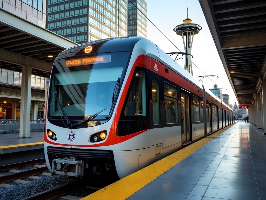
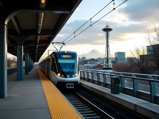
During my monthly visits to Microsoft's Redmond campus, I've watched Seattle's Link Light Rail grow from a limited line into an expanding network that now connects the airport to downtown and the University of Washington, with extensions to Bellevue and Redmond on the horizon. The light rail runs every 8-10 minutes during peak hours and offers breathtaking views of the city as it emerges from the Beacon Hill tunnel.
Buses complement the rail system, with Metro Transit operating extensive routes throughout the city and surrounding King County. The RapidRide lines (identified by letters A through F) offer frequent service on major corridors with fewer stops than regular routes.
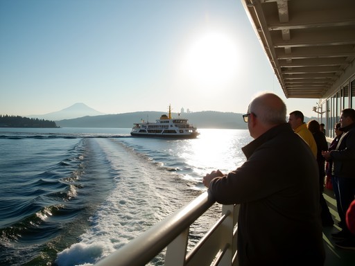
For water-bound explorations, the iconic Washington State Ferries and King County Water Taxi provide not just transportation but experiences in themselves—something I discovered during a soul-stirring sunrise crossing to Bainbridge Island last autumn.
Before arriving, I recommend downloading the Transit app which provides real-time arrivals and journey planning across all of Seattle's transit options. This app has saved me countless times when meetings ran late or when unexpected Seattle showers altered my plans.
💡 Pro Tips
- Purchase an ORCA card immediately upon arrival at the airport Link station ($5 for the card itself, then load value)
- Consider a day pass ($8) if you'll make more than 3-4 trips in a day
- For weekend visits, remember that Sunday schedules are significantly reduced on many routes
Airport to Downtown: Your Seattle Journey Begins
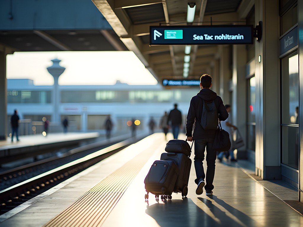
One of Seattle's greatest transit achievements is the direct Link Light Rail connection from Sea-Tac Airport to downtown. After clearing customs during my recent February visit, I followed the well-marked signs to the SeaTac/Airport Station, just a short covered walkway from the terminal.
The journey from airport to downtown takes approximately 40 minutes—slightly longer than a taxi in good traffic but significantly more reliable during rush hours. More importantly, at just $3.25 one-way, it's a fraction of the $45-55 you'd spend on rideshare or taxi services.
The train emerges from the airport area into Tukwila, offering glimpses of Mount Rainier on clear days before diving into the Rainier Valley. This diverse neighborhood showcases Seattle's multicultural fabric, with Ethiopian restaurants, Vietnamese markets, and community gardens sliding past your window.
As the train approaches downtown, prepare for the stunning moment when it emerges from the Beacon Hill Tunnel, presenting a postcard-perfect view of the city skyline, Elliott Bay, and the Olympic Mountains beyond. I often find myself pausing my audiobook or meditation at this precise moment, simply to absorb the natural grandeur that frames this tech-forward city.
For business travelers like myself who pack light but need organization, I've found the compact backpack perfect for navigating transit. It has dedicated laptop storage and expands enough for overnight essentials while remaining comfortable during standing-room-only rush hour rides.
💡 Pro Tips
- Trains run every 8-10 minutes during peak hours, 10-15 minutes otherwise
- Allow 15 extra minutes during your first journey to purchase an ORCA card
- If arriving late (after midnight), consider the A-Line RapidRide bus which runs 24 hours
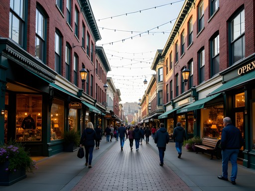
Downtown Core: Walking the Heart of Seattle
Seattle's downtown core is wonderfully compact and walkable—a blessing I've come to appreciate after spending time in sprawling metropolises. From Pioneer Square to Pike Place Market to the retail core, most attractions sit within a 20-30 minute walk of each other.
However, Seattle's topography presents a unique challenge: hills. The city was essentially built on a series of steep inclines that can test even the most dedicated walker. During my spiritual counseling work with tech employees, I often use Seattle's hills as a metaphor for life's challenges—sometimes the most direct path isn't the easiest, and there's wisdom in finding alternative routes.
Fortunately, Seattle offers several creative solutions for hill-avoidance. The Downtown Seattle Transit Tunnel provides underground passage for light rail and some bus routes. Above ground, look for public elevators, escalators, and the delightful Harbor Steps connecting the waterfront to First Avenue.
My favorite downtown walking hack is utilizing the city's indoor shortcuts. Columbia Center, Rainier Square, and Westlake Center all offer climate-controlled passages that can help you avoid both hills and rain. The Seattle Municipal Tower even connects to the Pioneer Square light rail station via an underground concourse.
When exploring downtown, comfortable footwear becomes your most valuable asset. After my mountaineering accident left me with occasional ankle pain, I've become particular about proper support. My walking shoes have proven ideal for Seattle's varied terrain and unpredictable weather, offering both the support needed for urban hiking and the waterproofing essential for those famous Seattle drizzles.

💡 Pro Tips
- Download the free Seattle Waterfront and Downtown map from the Visit Seattle website before your trip
- Use the Pike Place Market elevator to avoid the steep climb from the waterfront
- The Seattle Central Library offers free public restrooms, Wi-Fi, and a place to rest in architectural splendor

Beyond Downtown: Neighborhood Explorations by Bus
While downtown Seattle contains many must-see attractions, the city's soul resides in its diverse neighborhoods. Thanks to an extensive bus network, these distinct communities are easily accessible without a car.
Capitol Hill, just east of downtown, has been my go-to neighborhood for unwinding after intense business meetings. The 10, 11, and 49 bus routes will get you there in minutes. This vibrant area blends Seattle's LGBTQ+ culture, indie music scene, and innovative dining. I find particular solace in Volunteer Park, where the water tower offers panoramic views and the Conservatory provides a tropical respite during rainy days.
Fremont, self-proclaimed 'Center of the Universe,' embodies Seattle's quirky spirit. Catch the 40 bus and within 20 minutes you'll be face-to-face with the famous Fremont Troll, a massive sculpture lurking under the Aurora Bridge. During my last visit, I discovered a hidden speakeasy behind a bookshelf in a seemingly ordinary bar—these serendipitous finds are the rewards of car-free exploration.
Ballard, once a Scandinavian fishing village, now offers a perfect blend of maritime heritage and contemporary culture. The RapidRide D Line provides direct access to this northwestern neighborhood. Sunday mornings here are sacred to me—starting with the Ballard Farmers Market, followed by fresh-baked cardamom bread at Cafe Besalu, and concluding with quiet contemplation at the Hiram M. Chittenden Locks where salmon navigate the fish ladder in summer months.
For longer journeys between neighborhoods, I've found that a portable power source is essential. My power bank has saved countless journeys when Google Maps navigation drained my phone battery faster than expected.

💡 Pro Tips
- Use Google Maps' transit option for accurate bus routing between neighborhoods
- For evening adventures, check return bus schedules as some routes reduce frequency after 10pm
- Sit near the front of the bus for better views and easier communication with drivers, who are excellent sources of local information
Water Crossings: Ferries as Transportation and Experience
Seattle's relationship with water defines the city's character, and no car-free visit is complete without utilizing the extensive ferry network. Unlike many cities where water transit is merely functional, Seattle's ferries offer both transportation and transformative experiences.
The Washington State Ferry to Bainbridge Island is my personal meditation retreat. For just $9.25 round-trip (passengers only), you'll enjoy a 35-minute crossing with panoramic views of the Seattle skyline, Mount Rainier, and the Olympic Mountains. The island itself is walkable from the terminal, with Winslow's main street offering cafes, galleries, and the remarkable Bloedel Reserve gardens just a short bus ride away.
During a particularly challenging period after my accident, I established a ritual of taking the first morning ferry to Bainbridge, watching the sunrise illuminate the city behind me while practicing mindful breathing. The liminal space of being between destinations creates a perfect setting for reflection—something I now recommend to many of the tech professionals I counsel who struggle with work-life boundaries.
For a shorter but equally rewarding water journey, the King County Water Taxi to West Seattle departs from Pier 50 on the downtown waterfront. The 15-minute crossing costs just $5.75 one-way and delivers you to Alki Beach, where Seattle's founders first landed and where today's residents gather to play volleyball, build bonfires, and watch the sunset behind the Olympic Mountains.
When ferry-hopping, weather protection becomes essential as upper observation decks can be windy and wet. I never board without my compact waterproof jacket which packs into its own pocket when the sun emerges.

💡 Pro Tips
- Arrive at least 20 minutes before departure for passenger-only ferries
- Position yourself on the outdoor deck for the best photography opportunities
- The Bainbridge ferry terminal has luggage lockers if you're carrying bags
Tech Hub Connections: South Lake Union and Microsoft Country
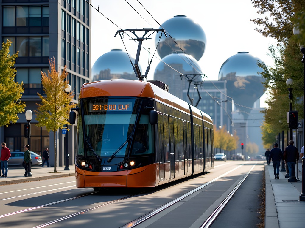
As someone who regularly travels between tech hubs, I've mastered the art of navigating Seattle's innovation corridors without a car. The South Lake Union neighborhood—home to Amazon's headquarters and countless startups—has transformed from an industrial afterthought into the beating heart of Seattle's tech ecosystem.
The South Lake Union Streetcar (affectionately nicknamed the S.L.U.T. by locals before official rebranding) connects this district to downtown. For just $2.25, this modern tram whisks you from Westlake Center to the shores of Lake Union in under 15 minutes. Along the way, you'll pass Amazon's spheres—remarkable glass biodomes housing thousands of plants alongside workspaces—and dozens of restaurants catering to the tech lunch crowd.
For those needing to reach Microsoft's campus in Redmond or other Eastside tech companies, Sound Transit's 545 Express bus provides direct service from downtown Seattle. While the Light Rail extension to Redmond is still under construction (expected completion in 2023), this express bus offers comfortable seating and Wi-Fi—perfect for last-minute presentation reviews.
During my monthly chaplaincy visits to various tech campuses, I've found that timing is everything. Eastside buses operate frequently during peak hours but can be sparse on weekends. The transit app's real-time tracking feature has proven invaluable for planning these cross-lake journeys.
For tech workers and visitors alike, I recommend exploring the Museum of History and Industry (MOHAI) in South Lake Union, which chronicles Seattle's evolution from logging town to tech powerhouse. The juxtaposition of historic wooden boats against the gleaming tech offices creates a powerful reminder of how quickly our world is changing—a theme I often explore in my counseling work with international business travelers experiencing culture shock.
💡 Pro Tips
- The 545 Express bus to Microsoft runs every 15 minutes during peak hours
- Visit the Amazon Spheres' public Understory exhibit on weekdays (reservations recommended)
- Use the pedestrian bridge at South Lake Union Park to reach the Museum of History and Industry
Final Thoughts
As my ferry glides back toward the Seattle skyline after a day on Bainbridge Island, I'm reminded that traveling without a car isn't just economically and environmentally sound—it's spiritually enriching. By surrendering control of the steering wheel, we open ourselves to the rhythm of a city, to chance encounters with locals, and to moments of reflection while waiting for the next bus or ferry. Seattle's comprehensive transit network transforms what could be mere transportation into experiences that connect us more deeply with place and self. Whether you're visiting for business meetings in South Lake Union or seeking personal renewal in the city's diverse neighborhoods, I hope this guide empowers you to discover Seattle's soul through its public transit arteries. The Emerald City awaits—no driver's license required. As we say in my interfaith chaplaincy work: the journey itself is the destination.
✨ Key Takeaways
- Seattle's ORCA card provides seamless access to buses, light rail, streetcars, and water taxis
- The Link Light Rail offers direct airport-to-downtown service for just $3.25
- Ferry crossings provide both transportation and some of the region's most spectacular views
- Neighborhood exploration via bus reveals Seattle's diverse character beyond downtown landmarks
📋 Practical Information
Best Time to Visit
year-round, though summer (June-September) offers driest weather and longest daylight hours
Budget Estimate
$50-75/day for transportation and activities
Recommended Duration
2-3 days minimum
Difficulty Level
Easy


Comments
Kimberly Murphy
Brilliant guide, Jason! I was in Seattle last summer and completely agree about the public transit. The water taxi to West Seattle was a hidden gem - incredible skyline views and Alki Beach was perfect for a sunset picnic. One tip for anyone heading there: download the Transit Go Ticket app before your trip. It made hopping on buses so much easier than fumbling for change. Also, don't miss the Ballard neighborhood - the Sunday farmers market is fantastic, and you can walk to the Ballard Locks afterward to watch boats and salmon (depending on season). Seattle's definitely one of the most transit-friendly US cities I've visited!
cityperson
Ooh, we missed the water taxi! Adding that to my list for next time. Is it covered by the ORCA card?
Kimberly Murphy
Yes! The water taxi does accept ORCA cards. Such good value for those views!
smartstar
This guide is perfect timing! Just booked flights to Seattle for March and was debating whether to rent a car. You've convinced me public transit is the way to go! Question though - how's the bus system for getting to Capitol Hill? I've heard that's where all the cool restaurants are. Also planning to bring my waterproof daypack since I heard Seattle rain is no joke. Any neighborhoods I absolutely shouldn't miss?
wanderlustway
Capitol Hill is super easy! You can take the light rail straight there from downtown (just a couple stops). Great food scene, especially along Pike/Pine corridor.
summerclimber
Going in December - is the ferry to Bainbridge worth it in winter?
Kimberly Murphy
Absolutely! The ferry ride is gorgeous in winter - moody skies, misty mountains. Just bring layers and grab a hot drink from the onboard cafe. The town is charming with fewer tourists too!
summerclimber
Thanks! Adding it to my itinerary then!
cityperson
Just got back from Seattle last month and did the whole trip car-free! The Link light rail from the airport was super easy - clean, frequent, and way cheaper than a rideshare. We stayed downtown and walked everywhere. The ORCA card was totally worth it since we hopped buses to Fremont and Ballard. Only thing I'd add is that some of the hills downtown are STEEP - my calves were burning by day 3! 😅
wanderlustway
Those hills are no joke! I counted 7 flights of stairs on one block near Pike Place.
cityperson
Right?! I was NOT prepared for that! But great views at the top, so worth it.
wanderlustway
Finally! A Seattle guide that doesn't assume everyone's renting a car. The ferry tips are gold.
journeyvibes
Great guide! Quick question - are the ferries running on a regular schedule these days or should I check ahead? Last time I was in the PNW some routes had reduced service. Also, is the water taxi to West Seattle worth it for the views?
backpackstar
i wanna know this too!
wavelegend
what about when it rains? does the bus system still work well or do things get delayed?
journeyvibes
The buses run fine in rain (which is good because it rains ALL the time there lol). Just bring a good rain jacket and comfortable waterproof shoes. The covered bus stops downtown are clutch.
nomadmood
Love this!! Seattle is SO underrated for public transit. Way better than LA lol
Nicole Russell
Jason, this guide is EXACTLY what I needed when I visited Seattle last fall! I did the exact same thing - no car rental - and honestly it was one of my favorite city experiences. The light rail from the airport was so easy and cheap compared to a rideshare. One tip I'd add: get the ORCA card right at the airport because you can use it on literally everything - buses, light rail, even the ferries. I loaded $40 on mine and it lasted my whole 4-day trip. The Fremont neighborhood was my absolute favorite - quirky, walkable, and the Sunday market is incredible. Did you make it up to the Ballard Locks? Such an underrated spot!
wavelegend
how long does it take from airport to downtown on the light rail?
Nicole Russell
About 35-40 minutes! Super smooth ride and you get great views coming into the city.
backpackstar
this is so helpful! going in august
Nicole Russell
August is perfect! The weather will be amazing for walking around. Definitely do the ferry ride to Bainbridge!
Venture X
Premium card with 2X miles, $300 travel credit, Priority Pass