

Disclosure: This article contains affiliate links. We may earn a commission from purchases at no extra cost to you, which helps our travel content.
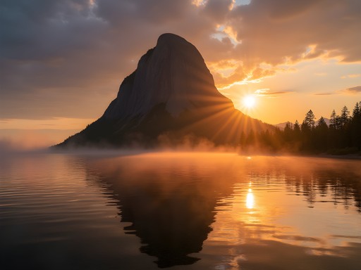
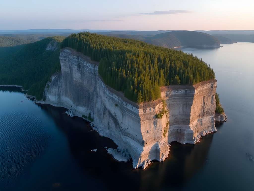
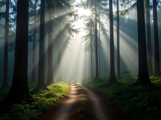
Standing at the edge of Lake Superior, watching the morning mist roll off what appears to be a massive stone giant in repose, I'm reminded why I abandoned my climate-controlled lab for these wilderness excursions. The Sibley Peninsula, or what locals call the Sleeping Giant, isn't just a geological anomaly—it's a masterclass in diabase sill formations that would make any materials engineer weak at the knees. And if you've played The Witcher 3, you'll recognize the uncanny resemblance to the Skellige coastline—minus the drowners, thankfully.

The Geological Marvel That Is The Sleeping Giant
Let me geek out for a moment: what you're seeing at Thunder Bay isn't just any mountain formation. The Sleeping Giant represents a textbook example of a Logan diabase sill—essentially an intrusion of magma that solidified between existing rock layers during the Mesoproterozoic era. The differential erosion over millennia has created this anthropomorphic silhouette that Indigenous Ojibwe legend identifies as Nanabijou, turned to stone for revealing the location of silver deposits to European settlers.
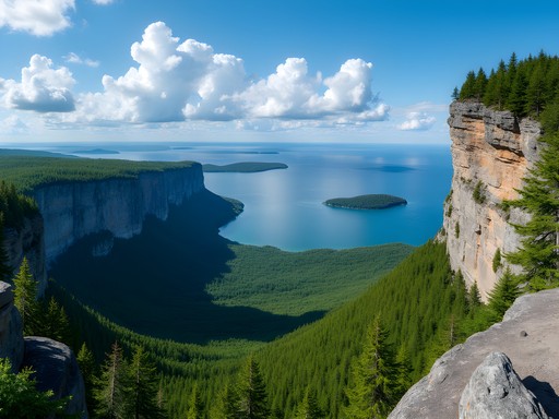
As I hiked the Top of the Giant trail with my trekking poles (essential for the 22km round trip with 290m elevation gain), I couldn't help but analyze each rock layer like pages in Earth's autobiography. The mesa-like structure of the Giant's 'chest' showcases classic columnar jointing—the same phenomenon you'll see in Minecraft's basalt columns, though the game developers took some creative liberties with the scale.
What makes this formation particularly fascinating is how the harder diabase cap has protected the softer shale beneath, creating the distinctive profile that has become iconic to the Thunder Bay region. Nature's erosion algorithm at its finest.

💡 Pro Tips
- The Top of the Giant trail is strenuous—bring at least 2L of water per person
- Start early (before 9am) to avoid afternoon thunderstorms common in summer months
- Download offline geological maps—cell service is spotty at best
Trail System Breakdown: Choose Your Difficulty Setting
The Sleeping Giant Provincial Park offers a progression system of trails that would make any game designer proud—each with increasing difficulty and correspondingly impressive reward views.
Beginner Level: The Sea Lion and Thunder Bay Lookout trails (1-2km) provide tutorial-mode experiences with minimal elevation gain but solid viewpoints. Perfect for testing your gear or acclimating before the more challenging routes.
Mid-Level Grind: The Kabeyun Trail (7km one-way) follows the shoreline to the Giant's feet, with side quests to Tee Harbour and Sea Lion. This trail is relatively flat but requires endurance.
Expert Mode: The Top of the Giant Trail (5.5km one-way plus the approach via Kabeyun) is the crown jewel, taking you literally onto the Giant's chest at 250m above Lake Superior. The final kilometer involves a steep climb that had me checking my fitness tracker to confirm that yes, my heart rate was indeed approaching redline territory. The panoramic view from the top renders in 360 degrees with draw distances that would crash a gaming PC.
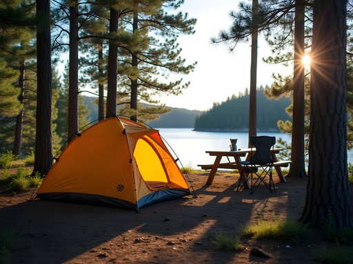
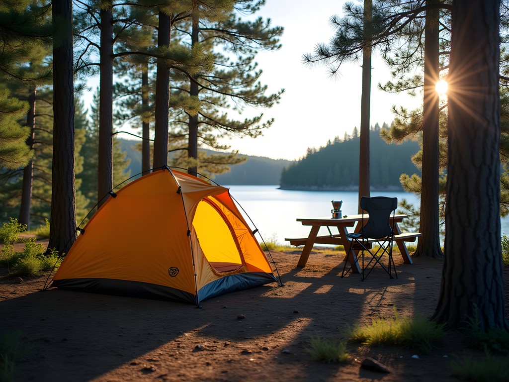
I spent two nights camping at Marie Louise Lake Campground, which served as my base camp for daily excursions. My ultralight tent was overkill for car camping, but I appreciated its quick setup after returning exhausted from the Top of the Giant trail.

💡 Pro Tips
- The Kabeyun-Talus Lake-Top of the Giant loop is the optimal route for experienced hikers
- Backcountry sites require reservations through Ontario Parks (book months ahead for summer weekends)
- Bring microspikes if hiking before June—north-facing slopes hold ice well into late spring
Budget-Friendly Base Camp Options
As someone who's analyzed material costs professionally, I appreciate efficiency in travel budgeting. Thunder Bay offers surprisingly economical options for the solo traveler willing to embrace a bit of roughing it.
Marie Louise Lake Campground within the park provides the optimal cost-to-convenience ratio at approximately $40-50 CAD per night. Sites are well-maintained with access to potable water and clean (if basic) facilities. I secured site #43, which offers a buffer of trees between neighbors and a short walk to the shower building—a luxury I deeply appreciated after accumulating multiple layers of hiking grime.
For the truly budget-conscious, backcountry sites along the Kabeyun Trail run about $10-15 CAD per person per night. I encountered several solo hikers at Tee Harbour who had established minimalist setups with nothing more than a hammock camping system slung between trees.
If you require climate control and indoor plumbing (no judgment—I've spent enough nights in tents to appreciate modern conveniences), Thunder Bay's motels start around $80-100 CAD, with the added benefit of being closer to restaurants. The 45-minute drive from city to park each morning would cut into hiking time, however.
To maximize value, I brought my backpacking stove and prepared simple meals at my campsite. The initial investment in camping gear pays dividends over hotel costs after just a few trips, with the added benefit of reducing your carbon footprint—a calculation any materials engineer can appreciate.
💡 Pro Tips
- Reserve campsites at least 3 months in advance for summer weekends
- Thunder Bay has several large grocery stores for stocking up on affordable provisions
- Provincial park fees are separate from camping fees—get the seasonal pass if visiting multiple Ontario parks

Digital Preservation: When Gaming Meets Geology
Part of my mission in visiting these geological formations is documenting them for both scientific record and digital preservation. The Sleeping Giant's distinctive profile has already inspired digital recreations in several games—though rarely with geological accuracy.
Using my drone, I captured comprehensive footage of the formation from multiple angles (after confirming drone usage was permitted in specific areas). These data points will contribute to a 3D model I'm developing that accurately represents not just the visual appearance but the actual geological composition of the formation.
What fascinates me is how game developers interpret these natural wonders. The basalt columns seen in the Giant's upper sections appear in numerous games from Minecraft to Skyrim, yet few accurately represent their hexagonal patterns or formation processes. As climate change accelerates erosion patterns, these digital twins become increasingly important records.
For fellow geology enthusiasts visiting Thunder Bay, I recommend bringing a rock hammer for examining (not removing!) samples along permitted areas. The varied mineral compositions you'll encounter provide excellent examples of Precambrian shield geology.
The intersection of digital preservation and geological documentation creates a fascinating record of these formations—one that may outlast the physical landmarks themselves as erosion continues its relentless work. There's something poetically circular about using technology to preserve the very geological processes that eventually enabled our technological civilization.
💡 Pro Tips
- Check drone regulations before flying—certain areas prohibit drone usage to protect wildlife
- The Thunder Bay Museum has an excellent geological exhibit worth visiting on rainy days
- Photograph interesting rock formations with a scale reference (coin or hiking pole) for better documentation
Final Thoughts
As I packed up my gear and took one final look at the Giant's silhouette against the evening sky, I couldn't help but calculate the improbability of it all—the precise geological conditions required to form this massive diabase sill, the specific erosion patterns needed to create the anthropomorphic profile, and the astronomical odds that humans would evolve in time to witness and appreciate it before it eventually erodes away. The Sleeping Giant may appear permanent on our human timescale, but geologically speaking, it's just a fleeting frame in Earth's continuing animation.
For solo travelers seeking that perfect balance of challenging trails, remarkable geology, and budget-friendly adventure, Thunder Bay's Sleeping Giant delivers exponentially more than its modest entrance fee suggests. Whether you're analyzing rock formations or simply seeking that perfect screenshot-worthy vista, this provincial park offers resolution and render distances that no gaming engine can yet match.
Next time you're debating between another gaming session or an outdoor adventure, remember that Thunder Bay offers both—a chance to witness the natural formations that inspire digital worlds while creating memories no GPU can render. Just watch your step on those cliff edges—unlike games, there's no respawn point in real life.
✨ Key Takeaways
- The Sleeping Giant formation is a 1.1 billion-year-old diabase sill with remarkable geological significance
- Trail difficulty ranges from beginner to expert, with the Top of the Giant trail offering the most spectacular views
- Budget-friendly camping options make this an accessible weekend adventure for solo travelers
- Summer months (June-August) provide optimal hiking conditions with minimal snow and moderate temperatures
📋 Practical Information
Best Time to Visit
June through September
Budget Estimate
$150-250 CAD for a weekend (including camping fees, park entrance, and food)
Recommended Duration
2-3 days minimum
Difficulty Level
Intermediate (With Options For Both Beginner And Advanced Hikers)


Comments
Jean Wells
Excellent breakdown of the trail system, Mark. I hiked the Giant back in 2019 during a solo trip through Ontario, and your description of the Sea Lion trail brought back vivid memories. What struck me most was the dramatic contrast between the forested approach and that sudden opening to the Lake Superior vista - almost jarring in its beauty. I'm curious about your mention of digital preservation techniques. Are you using photogrammetry for geological documentation? I've been experimenting with similar methods in volcanic regions around Hokkaido and would be interested to compare notes on how different rock formations respond to 3D scanning.
Mark Flores
Jean, yes! I've been using photogrammetry combined with LiDAR scanning when possible. The columnar basalt formations at the Giant are fascinating subjects - the texture detail you can capture is incredible. Would love to hear about your volcanic work. The weathering patterns must be completely different from what I'm seeing with the diabase here.
happyguide7171
This looks amazing! Going in March - do you know if the trails are still accessible then or too snowy?
Mark Flores
March can be tricky! Some trails will still have significant snow and ice. I'd recommend checking with the park office before you go - they're really helpful about current conditions. If you do go, bring microspikes for sure.
happyguide7171
Thanks! Will definitely call ahead
starnomad
OMG JUST BOOKED MY TRIP TO THUNDER BAY FOR APRIL!!! This post could not have come at a better time! So excited to see the Sleeping Giant in person after years of dreaming about it! Your trail breakdowns are EXACTLY what I needed for planning. THANK YOU!!!
mountainqueen
April might still have snow on some trails - check conditions before you go!
starnomad
Thanks for the heads up! I'll definitely call the park office closer to my trip date.
redlife
Did the Top of the Giant trail last summer and it was one of the best hikes I've done in Ontario. Tough climb but so worth it. Pro tip: start EARLY. We started at 7am and had the summit almost to ourselves. By the time we were heading down around noon it was getting crowded. Also the bugs in July were pretty intense, bring bug spray for sure.
redgal
Great writeup! As someone who photographs landscapes, what time of day would you recommend for the best lighting on the Giant? And are there any specific vantage points that work particularly well for sunrise/sunset shots?
Mark Flores
Morning light is magical - try Thunder Bay Lookout for sunrise. For sunset, the view from Tee Harbour is stunning. If you can time your hike to be at the Top of the Giant around golden hour, the light on Lake Superior is incredible!
sunnywanderer
Anyone done this in winter? Thinking about going in February but not sure if the trails are accessible.
redlife
I've done winter hiking there! Some trails close but the park has winter routes. You'll need microspikes for sure - ice can be brutal. The views are incredible with snow though, totally worth it if you're prepared for the cold.
sunnywanderer
Awesome, thanks! Yeah I've got gear, just wanted to make sure it was actually open.
Jean Wells
Fascinating geological analysis, Mark. I visited Sleeping Giant in late September and was struck by the same formations you describe. The Kabeyun Trail offers exceptional vantage points for photography, particularly in early morning light. One consideration for international visitors: the park is quite remote with limited cell service, so download offline maps beforehand. The trail markers are generally well-maintained, but having a backup navigation system is prudent.
redlife
Good tip about the offline maps! Learned that the hard way in Algonquin last year.
travelmood
This looks amazing but I'm not super experienced with hiking. Which trail would you recommend for someone who's just getting into it? Don't want to bite off more than I can chew lol
Mark Flores
Hey! I'd say start with the Sea Lion trail - it's about 6km return and pretty manageable. Great views without the intense elevation gain. Just bring plenty of water!
travelmood
Perfect, thanks so much!
luckylover
That view though! Adding this to my Ontario bucket list.
George Hayes
Mark, your post brought back so many memories! We took our kids (9 and 11) to Thunder Bay last summer, and the Sleeping Giant was the highlight of our trip. We stuck to the easier trails like Sea Lion and Middlebrun Bay, which were perfect for family hiking. The kids were absolutely fascinated by the legend of the giant - they kept looking at the formation from different angles to see if they could spot him 'breathing'! One tip for families: the visitor center has these amazing junior ranger activity booklets that kept our kids engaged with identifying plants and animal tracks. The picnic areas are also really well maintained. Definitely one of the most family-friendly wilderness experiences we've had in Canada.
Venture X
Premium card with 2X miles, $300 travel credit, Priority Pass