


Disclosure: This article contains affiliate links. We may earn a commission from purchases at no extra cost to you, which helps our travel content.
As someone who studies ecological systems for a living, I've come to appreciate how cities, like ecosystems, have their own intricate networks and flows. San Francisco's public transportation system is a perfect example—a complex, interconnected web that, once understood, opens up the city in ways a car never could. During my recent weeklong conference at the California Academy of Sciences, I challenged myself to explore this iconic city without contributing to its notorious traffic congestion. What I discovered was not just a practical way to travel, but a more intimate, sustainable way to experience San Francisco's diverse neighborhoods and microclimates.

Understanding San Francisco's Transit Ecosystem
San Francisco's public transportation network resembles the layered habitats I study in conservation work—each system serving different niches while creating a cohesive whole. MUNI (San Francisco Municipal Railway) forms the foundation with its buses, light rail vehicles, cable cars, and historic streetcars reaching virtually every corner of the 7x7 mile city. BART (Bay Area Rapid Transit) connects to broader Bay Area destinations including Oakland and Berkeley. Ferries provide aquatic routes across the bay, while rideshares fill gaps when needed.
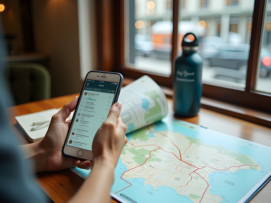
Before arriving, I downloaded the Clipper Card app to my phone, which functions as a universal transit pass for all Bay Area systems. This digital approach not only eliminated the need for a physical card but also allowed me to reload funds instantly whenever needed. The app tracks your transit history and calculates daily and monthly fare caps, ensuring you never pay more than necessary.
For longer-term visitors, consider purchasing a Muni Visitor Passport, which offers unlimited rides on Muni buses, light rail, cable cars, and historic streetcars for 1, 3, or 7 consecutive days. At $24 for a single day, it pays for itself after just two cable car rides (normally $8 each).
💡 Pro Tips
- Download transit apps before arriving: Clipper Card app for payments and Citymapper or Transit app for real-time schedules
- Consider a 7-day Muni Visitor Passport ($47) if staying a week—it pays for itself quickly
- BART and Muni are separate systems with different payment structures, though Clipper Card works for both
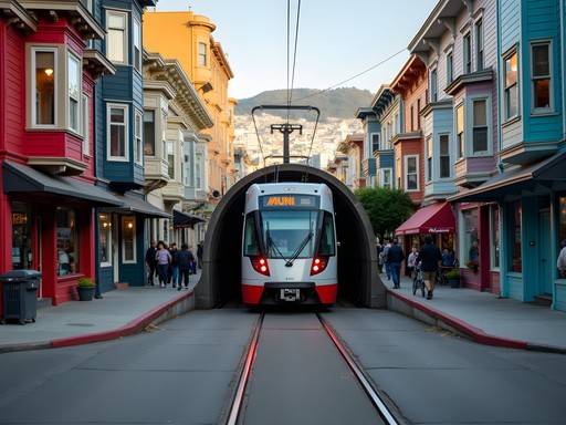
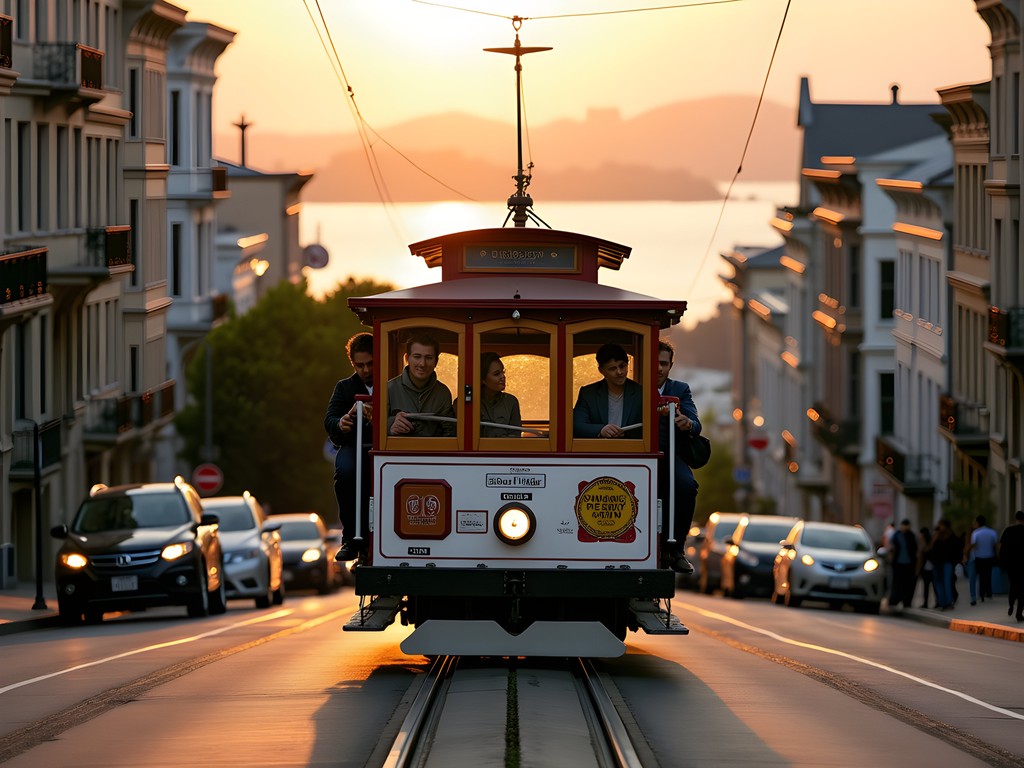
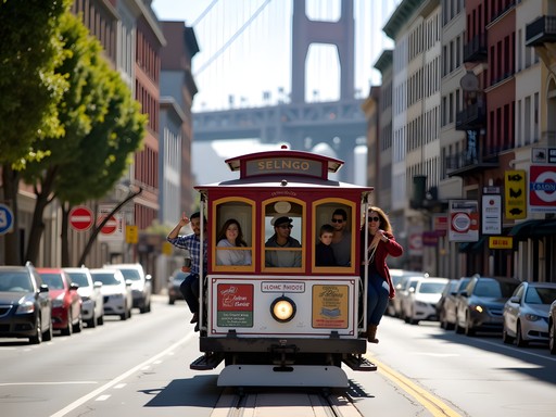
Cable Cars & Historic Streetcars: More Than Just Tourist Attractions
While many visitors view San Francisco's iconic cable cars purely as tourist attractions, I discovered they're legitimate transportation options that happen to double as mobile historical experiences. These 19th-century marvels still climb impossibly steep hills using the same underground cable system designed in 1873. The Powell-Hyde line offers the most dramatic views, cresting Russian Hill before descending toward stunning Bay vistas.
One evening, after a day exploring the California Academy of Sciences in Golden Gate Park, I hopped on the Powell-Mason line near Union Square. As we climbed Nob Hill, a friendly grip man (cable car operator) named Miguel explained how the mechanical brake system works while pointing out architectural landmarks I would have missed otherwise.
The F-Market & Wharves historic streetcar line serves as both practical transportation and a moving museum, operating a fleet of vintage streetcars from around the world. I rode a 1928 tram from Milan, Italy, while traveling from the Castro to Fisherman's Wharf, enjoying both the vintage experience and practical transport.
For these historic rides, comfortable footwear is essential. I relied on my walking shoes which provided the support needed for hopping on and off these moving historical artifacts and exploring the neighborhoods between stops.
💡 Pro Tips
- Ride cable cars early morning or evening to avoid tourist crowds
- Board at less popular stops (like Van Ness & California) rather than end terminals to skip long lines
- Cable car tickets can be purchased through the MuniMobile app to avoid fumbling for cash
Neighborhood Hopping: The MUNI Bus & Metro System
While the historic transit options charm visitors, San Francisco's comprehensive bus and light rail network (MUNI) forms the practical backbone of daily transportation. With over 80 routes covering every neighborhood, mastering this system transforms the city from a collection of tourist highlights into an interconnected community tapestry.
The MUNI Metro light rail system operates underground downtown (sharing some stations with BART) before emerging to street level in outer neighborhoods. Lines are color-coded and named by letter (J, K, L, M, N, T). I found the N-Judah particularly useful, connecting downtown to the Sunset District, Ocean Beach, and Golden Gate Park.
Buses reach areas the rail doesn't cover, including some of my favorite discoveries. The 22-Fillmore took me through diverse neighborhoods from the Marina to Dogpatch, while the 33-Ashbury connected me to the historic counterculture district and some exceptional bookshops.
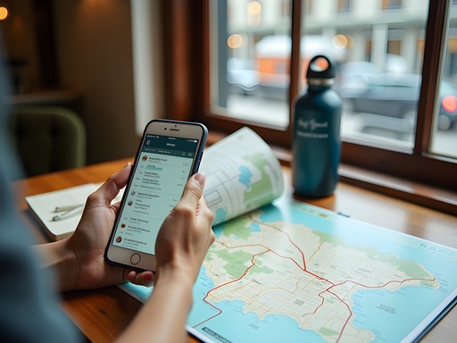
The best way to navigate this complex system is with a good transit app. I used transit planner which provides real-time arrivals, service disruptions, and optimal route planning. The app's offline functionality proved invaluable when cell service became spotty in some hilly areas.
One particularly foggy morning, I was grateful for my packable raincoat while waiting at outer neighborhood bus stops. San Francisco's microclimate shifts are notorious, and being prepared for sudden fog or wind made the transit experience much more pleasant.

💡 Pro Tips
- Use Citymapper or Transit app for real-time MUNI arrivals—official schedules aren't always reliable
- Board through any door on buses and streetcars, but tag your Clipper Card on the reader inside
- Buses display their number and destination on electronic signs—confirm before boarding

Beyond City Limits: BART, Ferries & Regional Connections
San Francisco's peninsular geography means some of the Bay Area's most fascinating destinations lie across water. Thankfully, regional transit connections make car-free exploration beyond city limits not just possible, but often preferable.
BART (Bay Area Rapid Transit) connects San Francisco to Oakland, Berkeley, and other East Bay communities via underwater tunnel. I took a day trip to Berkeley, visiting the university campus and ecological research facilities. The journey offered spectacular bay views as the train emerged from the Transbay Tube. BART also provides direct service to both San Francisco (SFO) and Oakland (OAK) airports, eliminating the need for expensive airport transfers.
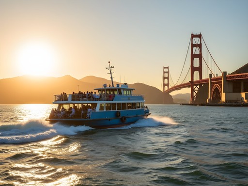
The ferry system offers another dimension of Bay Area exploration. I boarded at the historic Ferry Building (itself worth exploring for its food marketplace) for a scenic crossing to Sausalito. The ferry ride provided unparalleled views of the Golden Gate Bridge, Alcatraz, and the city skyline—essentially a bay cruise at transit prices. In Sausalito, I rented a electric bike to explore the waterfront community before returning via ferry.
For those venturing further, Caltrain connects San Francisco to Silicon Valley and San Jose, while Golden Gate Transit buses reach Marin County destinations not served by ferries. When planning these regional excursions, I packed my insulated water bottle to stay hydrated without generating plastic waste—a small but meaningful conservation choice while traveling.

💡 Pro Tips
- BART trains run every 15 minutes, with reduced frequency evenings and weekends
- Ferry schedules vary seasonally—check the Golden Gate Ferry or San Francisco Bay Ferry websites before planning trips
- Consider a day trip to Berkeley, Oakland, or Sausalito using regional transit for a broader Bay Area experience
Creating Your Own Transit Adventure: Practical Planning Tips
After a week of car-free exploration, I've developed a system for transit planning that balances efficiency with the serendipitous discoveries that make travel meaningful. Rather than organizing each day by specific attractions, I found it more effective to group destinations by transit corridors.
For example, I dedicated one day to the western corridor along the N-Judah line: morning at Ocean Beach watching shorebirds, midday exploring Golden Gate Park's California Academy of Sciences (where I chatted with fellow conservation researchers), and evening dining in the Inner Sunset neighborhood. This approach minimized transit time while allowing for spontaneous stops whenever something caught my interest.
For maximum flexibility, I kept a packable daypack that compressed into its own pocket when not needed. This allowed me to carry layers for San Francisco's microclimates, water, snacks, and any purchases without being burdened by a large bag all day.
I also recommend setting aside one day for a "transit adventure"—choose an unfamiliar line and see where it takes you. My adventure on the 43-Masonic bus led me through the Presidio's eucalyptus groves to a breathtaking overlook of the Golden Gate Bridge I might never have discovered otherwise.
For evening activities, I used personal safety light attached to my bag for additional visibility when walking to transit stops after dark. Small safety considerations like this helped me feel confident navigating the city at all hours.
💡 Pro Tips
- Group your sightseeing by transit corridors rather than trying to zigzag across the city in one day
- Build extra time into your schedule—transit delays happen, but they're opportunities to observe local life
- Consider accessibility needs when planning—not all MUNI stations have elevators, but all buses are equipped with ramps
Final Thoughts
As my week in San Francisco came to a close, I tallied the environmental impact of my car-free adventure: zero gallons of gas consumed, approximately 100 pounds of CO₂ emissions avoided, and countless moments of connection that would have been impossible from behind a windshield. From conversations with local commuters to unexpected wildlife sightings in urban parks accessible by MUNI, the city revealed itself in layers that car-dependent tourism often misses.
Navigating San Francisco without a car isn't just a practical choice—it's an immersive experience that connects you to the city's rhythm and reduces your environmental footprint. The initial learning curve of transit maps and schedules quickly gives way to confidence and freedom. You'll find yourself measuring the city not in miles but in experiences: the number of hills crested by cable car, neighborhoods explored by historic streetcar, or coastal vistas reached by bus.
Whether you're visiting for a weekend or a month, I encourage you to leave the rental car behind and embrace San Francisco's transit ecosystem. Your wallet, the environment, and your travel memories will all be richer for it. The next time you visit, perhaps our paths will cross on the N-Judah or a ferry to Sausalito—I'll be the one with binoculars, equally excited about urban transit efficiency and spotting pelagic birds from the deck.
✨ Key Takeaways
- The Clipper Card system works across all Bay Area transit systems, making payment seamless
- Historic cable cars and streetcars are functional transportation, not just tourist attractions
- Grouping activities by transit corridors maximizes efficiency and enjoyment
- Regional connections via BART and ferries enable car-free exploration beyond city limits
- Public transit offers environmental benefits while providing more authentic local experiences
📋 Practical Information
Best Time to Visit
May-October (summer fog patterns make July-August cooler than expected)
Budget Estimate
$30-50/day for transit (less with multi-day passes)
Recommended Duration
5-7 days to fully explore via public transit
Difficulty Level
Easy To Moderate (Some Hill Climbing Required)


Comments
Hayden Butler
Love this perspective, Emilia! I just spent a long weekend in SF and did the same car-free approach. One thing I'd add - the ferry to Sausalito is absolutely worth it, especially on a sunny afternoon. We grabbed lunch in Sausalito, walked around the waterfront, then took the ferry back at sunset. The views of the city skyline and Golden Gate Bridge from the water were stunning. It felt more like a mini cruise than just transportation. Also agreed on the cable cars - we rode them early morning around 7am and basically had the whole car to ourselves. Totally different experience than the midday tourist crush.
luckydiver
Early morning cable car is genius! Didn't think of that.
hikingking3024
Quick question - is the Clipper card worth it for just a 3 day visit? Or should we just do single tickets?
Emilia Tucker
Definitely get the Clipper card! Even for 3 days it's more convenient and saves a bit of money. Plus you can use it on BART, MUNI, and the ferries. You can load it with just what you need.
hikingking3024
Perfect, thanks!
luckydiver
This is super helpful! Going in May.
Emilia Tucker
Awesome! May is perfect weather for exploring the city on foot and transit. Have a great trip!
Casey Andersson
Emilia, I love how you framed this through an ecological lens! I spent three weeks in SF last year staying in Pacific Heights, and honestly the public transit completely exceeded my expectations. The MUNI pass was such good value. One tip I'd add: the ferries to Sausalito are absolutely stunning on a clear day, and you can bring wine and cheese aboard. I made a whole afternoon of it, wandering the waterfront town before catching the ferry back at golden hour. The views of the city skyline and Golden Gate Bridge from the water are just incomparable. Also discovered that the N-Judah line gets you right to Ocean Beach - perfect for sunset watching without dealing with parking nightmares.
tripwanderer
Wait you can bring wine on the ferry?? That's amazing, definitely doing this!
Casey Andersson
Yes! Just keep it low-key. Grab some good cheese from the Ferry Building before you board 😊
tripwanderer
Totally agree about the cable cars! Worth it even with the tourist crowds.
Casey Andersson
Right?! I rode them at sunset once and the views were absolutely magical. Bit pricey but such a San Francisco experience.
Hunter Thompson
Brilliant post, Emilia! As someone who's backpacked through 30+ cities, I can confirm SF has one of the most comprehensive public transit systems in the US. My top tip: don't miss taking the N-Judah line all the way to Ocean Beach for sunset - absolute magic and most tourists never make it out there! I found having a good transit map essential for spontaneous exploration. I used offline maps which worked brilliantly even in dead zones underground. Also worth noting that the cable cars get PACKED with tourists around midday - early morning is the time to enjoy them properly!
summerzone
That Ocean Beach sunset tip is gold! Adding it to my list for next time.
Hunter Thompson
Definitely do! And grab a coffee at Java Beach Cafe while you're there. Perfect way to end the day!
summerzone
Love this! Took the historic F-line streetcar along the Embarcadero last month and it was such a vibe.
citypro
This guide is exactly what I needed! I'm heading to SF next month and was stressing about renting a car with all those hills and parking horror stories. The breakdown of MUNI routes by neighborhood is super helpful. Quick question - how reliable did you find the NextMuni app? I've heard mixed things about real-time accuracy.
Hunter Thompson
Not the author but I was there last summer and NextMuni was pretty spot on for me! Occasionally off by a few minutes during rush hour, but way better than most cities I've visited. The BART predictions were nearly perfect.
citypro
Thanks Hunter! That's reassuring. Did you get a Clipper card or just pay as you go?
Hunter Thompson
Definitely get a Clipper card! You can load it on your phone now through Apple/Google Wallet. Saved me so much time and it's cheaper than individual tickets.
hikingking
Just got back from SF and used this guide - worked perfectly! Cable cars were definitely the highlight!
starlegend
If you're staying more than 3 days, the Muni Visitor Passport is totally worth it. We got the 7-day one and used it constantly. Just be prepared for some interesting characters on certain routes late at night!
Emilia Tucker
Great tip about the Visitor Passport! And yes, SF public transit definitely has its colorful moments, especially after dark. All part of the authentic experience though! 😊
Venture X
Premium card with 2X miles, $300 travel credit, Priority Pass