


Disclosure: This article contains affiliate links. We may earn a commission from purchases at no extra cost to you, which helps our travel content.
The first time I stood atop Twin Peaks, watching the famous San Francisco fog (affectionately called 'Karl' by locals) roll in like liquid mercury over the city grid below, I understood why this peninsula has captivated so many souls. Having traversed the Annapurna Circuit and scaled peaks in the Andes, I never expected an urban environment to stir the same reverence in me that remote mountains do. Yet San Francisco—with its iconic hills that ripple through neighborhoods like waves frozen in time—offers a unique convergence of natural splendor and human ingenuity that few cities can match. For the solo traveler with sturdy legs and a hunger for both wilderness and culture, this city provides an extraordinary playground where urban exploration and mountain adventure intertwine. Over one perfect spring week, with nothing but a daypack and my sketchbook, I discovered how San Francisco transforms the concept of 'city hiking' into something transcendent.

Urban Summits: The Quintessential City Trails
San Francisco possesses a geographical personality unlike any other major city I've encountered—47 named hills create a topographical playground that rewards the curious hiker with panoramic vistas around nearly every corner. The classic urban summit trilogy of Twin Peaks, Bernal Heights, and Tank Hill forms the backbone of any San Francisco hiking itinerary.
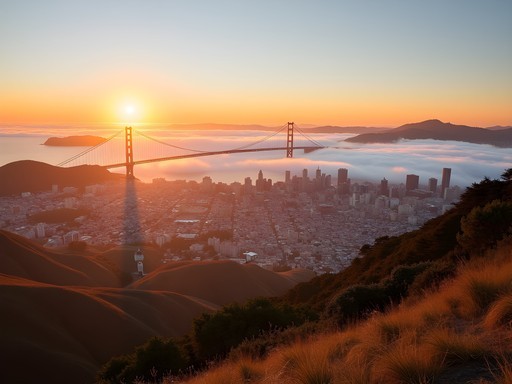
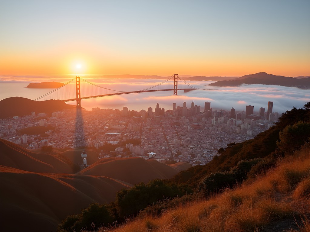
Twin Peaks remains the crown jewel, offering that postcard 360° view where the city's geometric precision meets the wild Pacific. I arrived just before sunset, when the fading light gilded the Financial District towers and the Bay Bridge began its nightly light show. The 0.7-mile loop trail at the summit provides different vantage points, though I recommend the eastern overlook for the most dramatic cityscape.
Bernal Heights Park offers a more neighborhood-centric experience. The dirt path circling the summit has a wonderfully communal feel—locals walking dogs, friends sharing sunset picnics, solo hikers like myself sketching the dramatic downtown skyline. The massive eucalyptus trees near the south slope release their distinctive medicinal scent when the afternoon breeze picks up, creating a multisensory experience I've tried to capture in my paintings.
Tank Hill remains my personal favorite—a hidden gem requiring a steep climb up a wooden staircase between residential buildings. What it lacks in size it makes up for in solitude and an uninterrupted western view where you can watch fog tendrils slide over Golden Gate Park toward downtown. I spent an entire afternoon here with my travel watercolor kit, attempting to capture the ephemeral quality of the city's famous fog as it transformed the landscape below.
💡 Pro Tips
- Visit Twin Peaks early morning (before 9am) or evening (after 5pm) to avoid tour buses and crowds
- Bernal Heights is best at sunset when the downtown buildings catch golden light
- Tank Hill requires good walking shoes as the approach is steep and can be slippery
The Coastal Trail: Where City Meets Sea
The Lands End Trail represents San Francisco's most perfect marriage of urban accessibility and wild coastal beauty. Beginning near the Cliff House restaurant, this relatively flat 3.4-mile path (round trip) hugs the rugged northwestern edge of the city, offering dramatic cliff-top views that reminded me of certain stretches along the Mediterranean coast near my hometown of Nice.
What distinguishes this trail is its historical layers. The path follows the route of a former rail line that once carried San Franciscans to the seaside Sutro Baths in the late 1800s. Today, the concrete ruins of these once-grand public baths create a hauntingly beautiful foreground to the endless Pacific horizon. I spent nearly an hour sketching these architectural remnants as waves crashed below—the perfect embodiment of nature reclaiming human ambition.
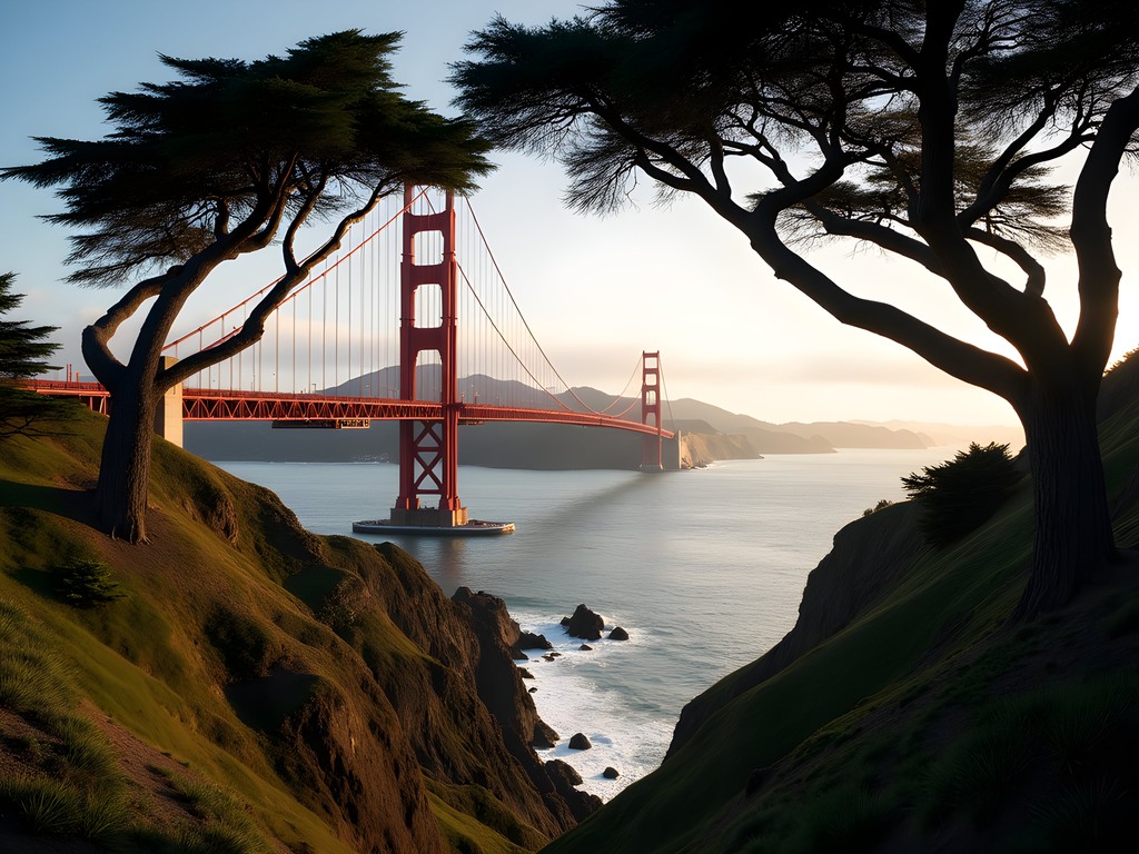
The trail's most magical moment comes at Eagles Point, where you round a bend and the Golden Gate Bridge appears, framed by cypress trees that bend dramatically from constant ocean winds. The perspective is entirely different from standard postcard images—more intimate, as if you've discovered the bridge from a secret vantage point.
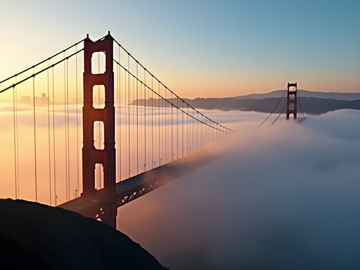
Microclimates dominate this hike. I experienced brilliant sunshine, pea-soup fog, and misty rain—all within a two-hour walk. This rapid weather transformation is quintessentially San Francisco, so layer appropriately. My packable down jacket proved invaluable, compressing small enough for my daypack when the sun emerged but providing essential warmth when the notorious afternoon winds picked up.
For those seeking solitude, take the Mile Rock Beach spur trail down wooden steps to a secluded stone labyrinth perched above crashing waves—a meditation spot that feels impossibly remote despite being within city limits.
💡 Pro Tips
- Start at Lands End Lookout for easier parking and access to maps/facilities
- Visit on weekday mornings for fewer crowds and better wildlife spotting opportunities
- Take the Mile Rock Beach spur trail for the hidden labyrinth meditation spot
The Mosaic Stairway Circuits: Art Meets Exercise
Perhaps no other hiking experience better represents San Francisco's creative spirit than the network of mosaic stairways connecting the city's hillside neighborhoods. These public art installations transform ordinary concrete steps into vibrant vertical galleries that provide both aesthetic pleasure and serious cardio workouts.
The 16th Avenue Tiled Steps in the Inner Sunset neighborhood was my first discovery—a 163-step masterpiece depicting a sea-to-stars theme in thousands of handmade ceramic tiles. What many visitors miss is that these steps are just one segment of a spectacular urban hiking circuit. Continue upward to Grandview Park (locals call it Turtle Hill) for a 360° panorama, then descend via the equally artistic Hidden Garden Steps a few blocks away.
In my sketchbook, I attempted to capture how these stairways function as both practical infrastructure and community gathering spaces. On my Tuesday morning visit, I encountered elderly tai chi practitioners at the summit, young parents showing toddlers the butterfly motifs in the tiles, and fellow solo travelers photographing the view back toward downtown.
The Lincoln Park Steps near the Legion of Honor offer a less-visited alternative with equally stunning tilework. What makes this location special is the contrast between the formal Beaux-Arts museum at the top and the wild coastal landscape visible beyond. The steps themselves feature an Art Deco-inspired pattern that feels like climbing through a vertical Klimt painting.
For photographers, these stairways present fascinating compositional challenges. My compact tripod proved essential for capturing long exposures during blue hour, when the tiles take on an almost luminous quality and the city lights begin to twinkle below. The compact design clipped easily to my daypack, making it practical for these urban adventures where carrying bulky equipment would be cumbersome.

💡 Pro Tips
- Visit mosaic stairs early morning for best light and fewest people in your photos
- Create a loop route connecting multiple stairways for a comprehensive urban hike
- Bring water and take breaks—climbing multiple staircases is more strenuous than many anticipate

Mount Tamalpais: The Ultimate Day Trip
When the urban grid begins to feel constraining, Mount Tamalpais State Park beckons from just across the Golden Gate Bridge. Rising 2,571 feet above Marin County, 'Mount Tam' (as locals affectionately call it) offers the most dramatic hiking within day-trip distance of San Francisco.
The East Peak Hike provides the quintessential introduction—a moderately challenging 3.7-mile loop with roughly 850 feet of elevation gain. What distinguishes this trail is how quickly it transports you from civilization to wilderness. Within 30 minutes of leaving the trailhead, I found myself in quiet redwood groves where the only sounds were bird calls and the soft crunch of my boots on the path.
The summit rewards with a panorama that contextualizes San Francisco in its broader geographical setting. On clear days, you can trace the entire bay system, from the city skyline to the distant Sierra Nevada mountains. I spent nearly an hour at the historic fire lookout tower, sketching the layered ridgelines and trying to capture how the afternoon light created distinct bands of color across the landscape.
The Dipsea Trail offers a more challenging alternative, following the route of America's second-oldest trail race. This 7.4-mile path (one way) connects Mill Valley to Stinson Beach, crossing diverse ecosystems including redwood forests, chaparral-covered ridges, and windswept coastal bluffs. The constantly changing terrain reminded me of certain Himalayan foothills, where a single day's hike traverses multiple distinct environments.
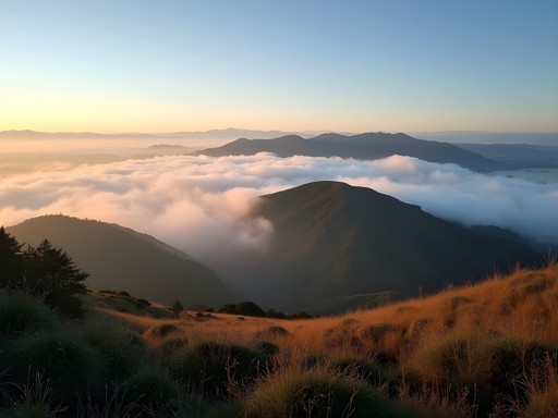
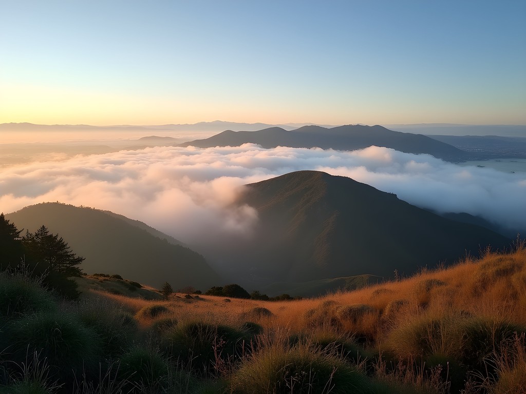
Perhaps Mount Tam's greatest gift is its fog performance. From these heights, you witness the famous marine layer as a living entity—sometimes a gentle white blanket below you, other times dramatic tendrils reaching through valleys like ghostly fingers. For photographers, the interplay of fog, mountains and light creates endless compositional possibilities.
Reaching Mount Tam requires transportation planning. While rental cars offer the most flexibility, budget travelers can use a combination of ferry (to Sausalito) and the seasonal Marin Transit Shuttle. I opted to join a local hiking meetup group, sharing fuel costs and gaining valuable local knowledge about the mountain's hidden viewpoints.
💡 Pro Tips
- Start early to maximize your hiking time and avoid afternoon fog that can obscure views
- The East-West fire road offers the best ridge walking with panoramic views in both directions
- Check shuttle schedules in advance as service is limited and seasonal
Angel Island: History and Hiking in the Bay
Angel Island represents San Francisco's most perfect fusion of historical significance and natural beauty—a place where hiking trails double as journeys through California's complex past. As someone fascinated by how landscapes hold cultural memory, this former immigration station and military outpost offered me a uniquely layered experience.
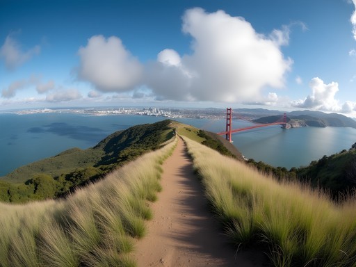
The 5-mile Perimeter Road provides the island's signature hike—a relatively flat, well-maintained path circling the entire island with constant bay views. What makes this trail exceptional is how the vista transforms with each quarter-mile. The eastern side frames the Berkeley and Oakland hills, while the western stretch offers unobstructed views of the Golden Gate Bridge and San Francisco skyline. The northern section reveals the less-visited Marin Headlands coastline.
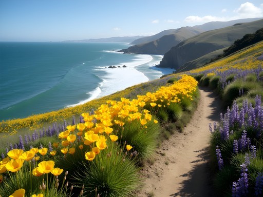
For a more challenging experience, the North Ridge Trail climbs to the 781-foot summit of Mount Livermore. The ascent through native oak woodland and restored grassland habitat reminded me of Mediterranean coastal mountains, particularly when spring wildflowers carpet the hillsides. From the summit, I experienced what might be the Bay Area's most complete panorama—a 360° view encompassing all major landmarks, from Alcatraz to the distant Farallon Islands.
What distinguishes Angel Island from other Bay Area hikes is the profound historical context. The Immigration Station museum documents the island's role as the 'Ellis Island of the West,' where thousands of Asian immigrants were detained under harsh conditions. Abandoned military buildings from various eras dot the landscape, creating poignant juxtapositions between natural beauty and complex human history. As I sketched these weathered structures against the backdrop of modern San Francisco, I contemplated how landscapes absorb and reflect our collective stories.
Reaching Angel Island requires a ferry from either San Francisco's Ferry Building or Tiburon in Marin County. I recommend the Tiburon route for budget travelers—it's typically less expensive and less crowded. Pack sufficient water and lunch supplies, as the island's small café has limited offerings and high prices. My collapsible water bottle proved invaluable, starting the day flat in my pack and expanding as needed for refills from water stations near the ferry landing.

💡 Pro Tips
- Purchase ferry tickets in advance during peak season (weekends/summer) as they often sell out
- Bring binoculars for wildlife spotting—harbor seals and sea lions frequently appear along the shoreline
- Download the Angel Island Association's audio tour app for historical context during your hike
Final Thoughts
As I boarded my flight back to Sydney, my sketchbook filled with San Francisco's undulating landscapes, I reflected on how this city redefines the relationship between urban environment and natural wonder. Unlike traditional mountain destinations that require complete separation from civilization, San Francisco offers a rare interweaving of cultural richness and topographical drama. For the solo traveler with limited time and budget, this convergence creates an ideal playground—where morning might find you summiting an urban peak with coffee in hand, while afternoon sees you traversing coastal wilderness just miles from downtown. The city's compact geography means that even a week allows for comprehensive exploration of both its famous hills and the surrounding mountain escapes. As an artist who has documented mountains across continents, I found San Francisco's vertical landscape uniquely compelling—not despite its urban character but because of how humanity and geography have shaped each other here across generations. The trails await, the vistas promise inspiration, and the hills, as always, invite discovery.
✨ Key Takeaways
- San Francisco offers an exceptional blend of accessible urban hiking and nearby wilderness experiences ideal for solo travelers
- Spring provides the optimal balance of wildflowers, moderate temperatures and pre-tourist season tranquility
- The city's extensive public transportation system makes car-free exploration feasible, even for reaching trailheads
- Pack layers for San Francisco's famous microclimates—conditions can change dramatically within hours or even minutes
📋 Practical Information
Best Time to Visit
March through May (spring)
Budget Estimate
$75-150/day including modest accommodations, public transportation, and simple meals
Recommended Duration
5-7 days
Difficulty Level
Moderate (Urban Trails Easy To Moderate, Nearby Mountain Trails Moderate To Challenging)


Comments
greenninja
how hard is mt tamalpais?
mountainone
Oh man this brings back memories!! I did the mosaic stairs last spring and my legs were SCREAMING by the end haha. But totally worth it - those tile designs are incredible and you get such cool views at the top. Did you do both the 16th Avenue and Moraga stairs? I only had time for one and chose 16th Avenue. Also that Karl the fog reference made me laugh, locals really do call it that!
Amit Sanchez
Yes! Did both in one circuit - it's a great workout. The Moraga stairs have a different vibe, more whimsical. Glad you enjoyed it!
skymaster
Twin Peaks is amazing! went last year
tripexplorer
Going in March - will it be too cold/foggy for the coastal trails? First time in SF and want to make sure I pack the right stuff
roamadventurer
March is actually pretty nice! Just bring layers. It can be sunny one minute and foggy the next. A light windbreaker is your best friend
beachvibes
Love this! Twin Peaks at sunset is magical
Douglas Bradley
Excellent write-up, Amit. I particularly appreciated your breakdown of the Mount Tam trails by difficulty level. When I visited last fall, I made the mistake of underestimating the Steep Ravine Trail - that elevation gain is no joke! The microclimates you mentioned are fascinating from a geographical perspective. I'd add that anyone doing the Dipsea Trail should factor in at least 30-45 minutes more than they think for all those stairs. The fog patterns really do create entirely different hiking experiences depending on timing.
tripexplorer
How hard is Mount Tam for someone who doesn't hike much? Thinking about trying it
Douglas Bradley
Start with the East Peak loop - it's moderate and gives you amazing views without being too demanding. Build up from there!
roamadventurer
The Lands End trail is absolutely my favorite! Did it last spring and the views of the Golden Gate Bridge are insane. Pro tip: go in the late afternoon when the light is perfect for photos. Also parking at Lands End can be brutal on weekends so get there early or just take the bus.
beachvibes
Yes! That parking situation is no joke. We circled for like 30 minutes lol
roamadventurer
Haha yeah it's the worst! The bus is honestly the move
tripmaster
Just got back from SF and did the Lands End trail! Those views of the Golden Gate Bridge are INCREDIBLE. Thanks for the inspiration!
roamone661
Has anyone done these trails using public transportation? I'll be staying downtown without a car next month.
Jean Wells
Absolutely! MUNI gets you to most urban trails. The 37 bus takes you near Twin Peaks, while the N-Judah train gets you close to Golden Gate Park. For Mount Tam, there's a weekend shuttle from Sausalito (take the ferry from SF). Download the MuniMobile app - incredibly useful.
Jean Wells
Amit's analysis of San Francisco's topographical diversity is spot-on. Having hiked extensively across Asia, I found SF's urban trails uniquely accessible via public transportation—a rarity in American cities. The 76X Marin Headlands bus on Sundays made reaching those coastal trails remarkably straightforward. One observation: the post doesn't mention seasonal variations. Winter brings dramatic wave action along the Coastal Trail, while spring transforms Mount Tamalpais with wildflowers. Each season offers distinctly different hiking experiences worth planning around.
tripmaster
That public transportation tip is gold! I always assumed you needed a car to reach the good trails.
Venture X
Premium card with 2X miles, $300 travel credit, Priority Pass